Description of the Map Sheet Onsala
Ragnar Sandegren and Per-Henrik Lundegårdh
Original title: Beskrivning till kartbladet Onsala
Series: Sveriges geologiska undersökning, Series Aa, No. 192
Original publication: Sveriges geologiska undersökning (Geological Survey of Sweden)
Language: English translation from Swedish
Source records: Description PDF · Related geological map sheet
SWEDEN’S GEOLOGICAL SURVEY
Ser. Aa. Map sheets at the scale 1:50000 with descriptions. No. 192.
   DESCRIPTION

                OF
MAP SHEET ONSALA
                       BY

      R. SANDEGREN and P. H. LUNDEGÅRDH

              WITH ONE PLATE

                 Price 10 kronor

                STOCKHOLM 1952

            ROYAL PRINTING OFFICE. P. A. NORSTEDT & SÖNER
                               520155
SWEDEN’S GEOLOGICAL SURVEY
Ser. Aa. Map sheets at the scale 1:50000 with descriptions. No. 192.
   DESCRIPTION

               OF
MAP SHEET ONSALA
                       BY

     R. SANDEGREN and P. H. LUNDEGÅRDH

             WITH ONE PLATE

               STOCKHOLM 1952

           ROYAL PRINTING OFFICE. P. A. NORSTEDT & SÖNER

                              520155
CONTENTS
Introduction by R. Sandegren. Extent of the map sheet. Topographic conditions. Watercourses and lakes. Vegetation. Settlement and livelihoods. Communications. Main features of the geological development of the area — 5
Bedrock by P. H. Lundegårdh — 12
- Introduction — 12
- Supracrustal formation — 13
- Greenstones — 13
- Gneisses — 16
- Intrusive formation — 19
- Greenstones — 20
- Granites, gneiss granites — 23
- Pegmatite, aplite, vein gneisses — 33
- Post-Archean diabase — 39
- Geological development — 40
Quaternary deposits (Quaternary formations) by R. Sandegren — 47
- Glacial deposits — 47
- Roches moutonnées — 48
- Glacial striae — 48
- Till deposits — 50
- Block distribution — 62
- Shore-level changes — 65
- Late-glacial marine deposits — 66
- Post-glacial deposits — 70
- Marine sediments — 74
- Peatlands — 82
- Development of climate, vegetation, and animal life in relation to shore-level changes — 92
Ancient monuments — 97
Introduction.
By R. Sandegren.
The geological map sheet Onsala at the scale 1:50,000 (661 sq km), corresponding to the southeastern quarter of the topographic sheet Särö at the scale 1:100,000, falls entirely within Halland county and encompasses: of Fjäre härad: all of Onsala, the southern half of Vallda, and insignificant parts of Tölö, Fjärås, Hanhals and Ölmevalla parishes; of Viske härad: an insignificant part of Värö parish.
The land area of the Onsala sheet thus consists of the entire Onsala peninsula together with surrounding islands, islets and skerries, as well as a quite insignificant strip of the Halland mainland on the eastern side of Kungsbackafjorden at Örmanäs. The Onsala peninsula is surrounded to the E by Kungsbackafjorden, to the S and W by the open sea, which occupies more than 3/4 of the sheet’s area. The eastern coast of the peninsula is relatively high. It has a largely rectilinear course and lacks major headlands and bays. The southern and western coasts, by contrast, are rich in long projecting headlands, between which bays penetrate inland. Larger and smaller islands lie closest to land and are replaced toward the sea by low islets and skerries. The bays are continued inland by pronounced valley troughs and small plain areas, which are occupied by unconsolidated deposits, primarily clays and sands, fig. 1. The terrain is gently undulating and exhibits a rich variation between protruding bedrock hills and low-lying valleys and plains.
The largest headland on the south coast is Hållsunds udde, which forms the southern tip of the Onsala land. About 7 km SW of this lies the solitary island Nidingen, surrounded by dangerous reefs and equipped with lighthouses. W of Hållsunds udde follow the headlands formed by Skallanäs—Vessingsö and Mönster—Sönnerbergen. Between these, Skallahamn and Malö hamn penetrate deep into the land. Outside these good harbours lies the large Malön like a powerful breakwater. On the west coast, the large headland Fjärhals is noteworthy. Between this and Sönnerbergen lies Öckerö, which is separated from Sönnerbergen by Kyrkefjällssund and from Fjärhals by Öckerösund. Inside Öckerö and the surrounding archipelago, the aforementioned sounds merge into a broad, shallow fjord, from whose innermost part the largest clay plain of the Onsala peninsula extends toward NE to Mariedal and toward N to Stänkelås. N of Fjärhals lies Onsala Sandö in a broad bay, thereby occupying a position reminiscent of Öckerö’s. Furthest north on the west coast, Lerkilen penetrates toward SE and provides a good fishing harbour.
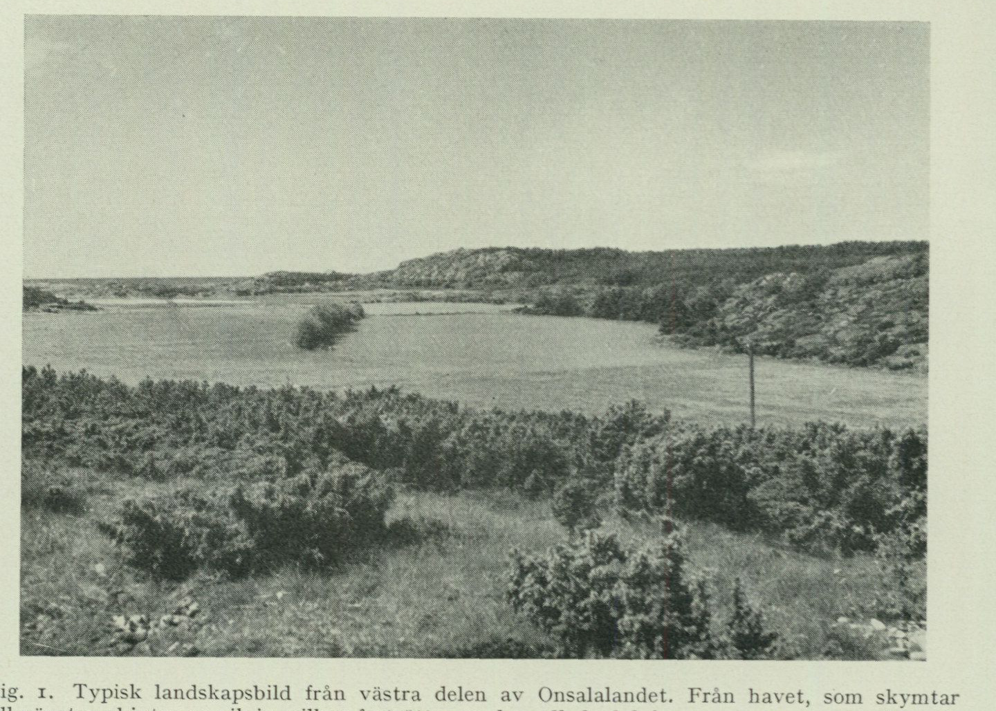
Fig. 1. Typical landscape view from the western part of the Onsala land. From the sea, glimpsed to the left, a bay projects inland, which is continued by the cultivated valley, surrounded by plateau-like rock areas. The photograph taken from Råö toward W with Fjärhals in the background. G. Lundqvist photo 1951.
The highest point of the Onsala peninsula, Hylteråsen, 84.72 m a.s.l., lies furthest to the NE in Vallda parish between Kungsbackafjorden and Lunnadalen, whose bottom lies only 12 m a.s.l. In the area around Hylteråsen, several other points reach considerable height, e.g. one barely a km SE of Hylteråsen and immediately NW of Lindås, both 73 m, S of Bolgen 71 m and NE of Skällared 68 m. The smaller valley depressions in this area lie between 20 and 30 m a.s.l. Both W and S from here, the land descends, as the bedrock tops successively become ever lower and the valley bottoms gradually reach sea level.
The eastern, straight boundary of the Onsala peninsula is of ancient tectonic origin. Kungsbackafjorden constitutes a southern, considerably broadened part of the pronounced, mainly NNE-to-SSW-trending rift valley, which from Vänern to Göteborg is followed by Göta älv. From Göteborg the valley continues in a south-southeasterly direction past Mölndal, Kållered and Lindome to Kungsbacka, and along this stretch is followed by the Västkustbanan railway. Along Göta älv, the rocks in the steep sides of the valley show clear crushing and slickenside phenomena, caused by movements in the earth’s crust. Judging from the different elevations of the bedrock plateaus on either side of the valley, the movements appear to have been of the nature of faults, at least in part. For example, at Trollhättan the bedrock plateau on the western side of the river is about 50 m higher than on its eastern side. Immediately north of Göteborg the relationship is the opposite. The Onsala peninsula appears to constitute a bedrock ridge that has been tilted in such a way that its eastern edge has been uplifted, while its western side has been downthrown. The movements between different bedrock blocks must thus have been quite complicated. In the broad Kungsbackafjorden
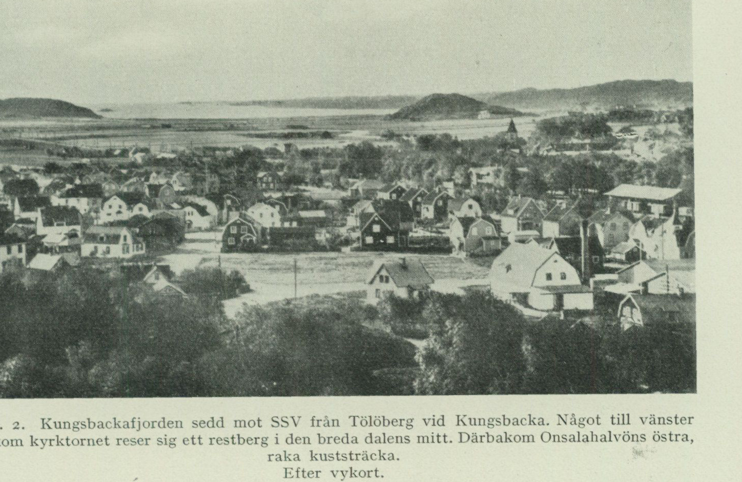
Fig. 2. Kungsbackafjorden seen towards SSW from Tölöberg at Kungsbacka. Somewhat to the left behind the church tower rises a residual hill in the middle of the broad valley. Beyond it, the eastern, straight coastline of the Onsala peninsula. After postcard.
At least a couple, perhaps several, reasonably parallel fracture zones ought to extend, of which one runs along the eastern side of the Onsala peninsula, the other or others farther east. In the middle of the valley, a whole series of prominently protruding residual hills remain, one of which is visible in fig. 2. The islands Kalvö, Brokö, Hällesö, Ramnö, Vindö, etc., situated within the Onsala map sheet in Kungsbackafjorden, are other such examples. The residual hills consist of rock masses situated between the various fracture zones, which have had greater resistance to erosion than the strongly crushed and disintegrated bedrock of the fracture zones themselves.
Parallel to Kungsbackafjorden, several marked north–south valleys appear within the Onsala peninsula, which are also likely to be rift valleys. Mention may be made of Lunnadalen in Vallda parish, the valley from Rösan to Skallahamn, and from Malö hamn towards north immediately E of Häcklehagen in Onsala parish. The depth figures on the sea chart finally give an indication that the row of small rocky islets and dangerous shoals situated W of the Onsala peninsula (Hallands Svartskär, Rön, Kungen, Tranebräkorna) belong to the eastern, raised edge of a Precambrian rock ridge tilted in the same manner as the Onsala peninsula.
Watercourses The watercourses of the area are very insignificant. They consist of small streams, and lakes. mostly with the character of ditches, which flow through the valleys and carry the precipitation water to the sea. No reservoirs of importance exist. The few lakes are quite small and shallow. They occupy small depressions in or between the mountains and have in most cases once been peat bogs, from which the peat has been dug out for use as fuel. Names such as Iglamossen and Stormossen in Onsala, Gärdamossen and Store mosse in Vallda parish indicate this.
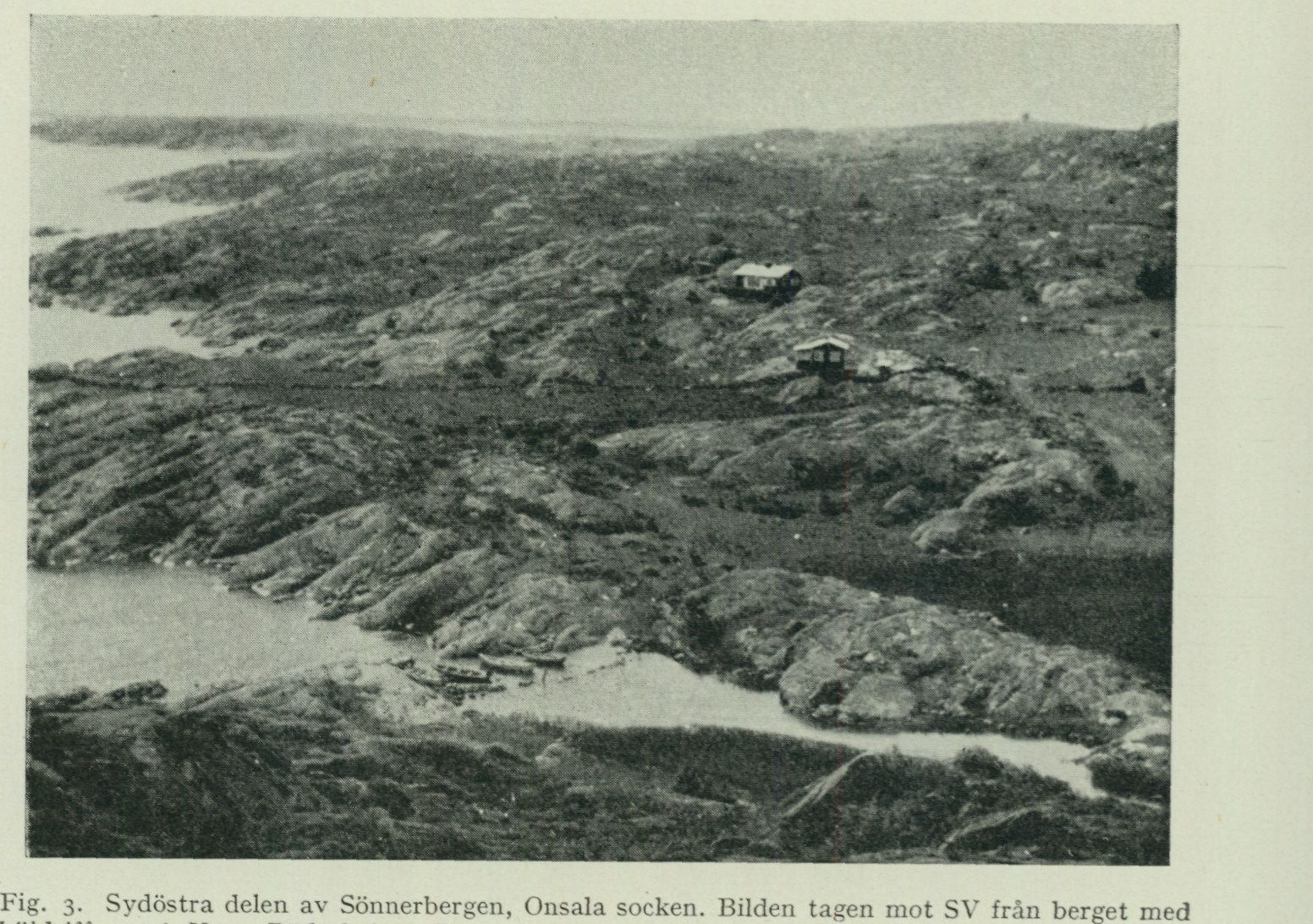
Fig. 3. Southeastern part of Sönnerbergen, Onsala parish. The photograph taken towards SW from the hill with the elevation figure 46, W of Röda holme. The straight, horizontal line extending to the nearest cottage is a stone fence. The house protruding at the horizon line to the right is the pilot lookout on Mönster. P. H. Lundegårdh photo. 1948.
Vegetation. The area, which was previously extremely poor in forest, still shows over large areas, especially in the west and south as well as on all islands and islets, almost exclusively bare rock, fig. 3. In ancient times the area was certainly largely covered by mixed oak forest. But ravages of war and imprudent felling brought about an almost complete devastation of the original forest. During recent decades, however, successful planting of mainly coniferous trees has taken place. One such area is, for example, Fjärskogen, situated along Kungsbackafjorden, between Vickan and Björkgläntan. In several places one can see how the oak, in the shelter of the growing cultivated forest, once again gains a foothold on land where it once previously held sway. The still bare mountains give large parts of the area a barren character, but in crevices and depressions between the mountains and below the east-facing cliff slopes, which offer shelter from the biting westerly wind, one encounters a luxuriant, southerly vegetation with all manner of deciduous trees and shrubs such as hawthorn, ivy, dog roses, blackthorn, and wild honeysuckle. On uncultivated parts of the moraine ridges, pasque flower (Pulsatilla) blooms in spring. Shores and islands harbour, especially in the west, a multitude of more or less rare species characteristic of the seashore.
The Onsala peninsula is an ancient settled area with roots dating back to the Stone Age. Stone Age Settlement habitation sites with flint debitage, pottery, and primitive tool types bear witness and livelihoods. to the fact that a population of fishers and hunters immigrated shortly after the ice had freed the land. From both the Bronze Age and the Iron Age there are both stray finds and graves. The large Iron Age cemeteries in particular indicate that the area then hosted a numerous population. The modern settlement of the Onsala area is, if one disregards the barren rocky headlands of the south and west coasts and a few elevated areas in the NE, including around Hylteråsen, which lack settlement, scattered but fairly dense. The old farms, several of which date back to the beginning of the eighteenth century, are built in a distinctive style that testifies to highly cultivated taste. The only place that has the character of a community is Gottskär. A large number of villas and small cottages have been built in recent years, mainly along the shores. They are inhabited only during the summer and have therefore not been included on the map. Agriculture has constituted a main livelihood ever since ancient times. The low-lying clay lands, which now form the principal basis of agriculture, were during the Stone Age largely covered by the sea, cf. fig. 32, but have during the land uplift that has continued since then been successively taken into use. The oldest settlement and cultivation were therefore probably tied to the till land, which is to a great extent cultivated. In the area around Onsala church one can see in many places how the most boulder-rich parts of the end moraine ridges appear as islands in the gently undulating field areas. Through human activity over more than five millennia, the Onsala area has been transformed from a natural landscape into a cultural landscape. A single example is sufficient to illustrate the great change in the appearance of the area that has taken place in this process. The innumerable boulders of all sizes, which originally lay scattered on the ground surface, have now been gathered into stone fences. These surround not only the cultivated land but also delimit, kilometre after kilometre, the various property parcels within the extensive barren rock terrains, which especially in earlier times were used as grazing land, cf. fig. 3. An important branch of industry has long been seafaring. Thus, a very large part of the male population is likely to have spent at least some part of their life at sea, and in the old sea-captain families’ farms all kinds of treasures are preserved, brought back from long voyages across foreign seas. In recent times the Onsala peninsula has become a popular resort for summer visitors, through which the spa and boarding house trade have come to provide an important contribution to the prosperity of the population.
The area lacks a railway but is provided with a network of good, though fairly Communications narrow roads. The main roads Kungsbacka—Gottskär, Rösan—Mariedal and . Onsala church—Mariedal are permanently paved. Bus routes departing from Kungsbacka serve with frequent services the routes Kungsbacka—Onsala church— Gottskär—Mariedal and Kungsbacka—Lerkil—Västra Hagen. Individual services are extended to Draget, Vessingsö, Orrviken and Råö.
Main features The bedrock of the area belongs, apart from some younger diabase dykes, to the Precambrian, of the geological which in itself encompasses the oldest geological formations occurring on our Earth. development. The rocks are mostly characterised as folded and more or less strongly schistose gneisses, which form part of the extensive area that has been called »the Southwest Swedish Gneiss Region». Several different attempts to interpret the geological mode of formation and development of this very complexly built gneiss area have previously seen the light of day. During the mapping in recent years of the geological map sheets Onsala and Särö, P. H. Lundegårdh has, through detailed study of the structural relationships of the rocks, sought to distinguish rock units of different origin and age, whereby he has been able to present an account of the development of the area that shows agreement with that obtained in other Swedish Precambrian areas.
Thus, among the rocks of the Onsala district, there has been distinguished an oldest formation formed at the Earth’s surface, consisting of volcanic eruptive products (lavas and tuffs) together with sediments. As a consequence of pressure and various types of movements in the Earth’s crust, the rocks of this formation have been compressed into folds reaching considerable depth and have partly undergone remelting. The molten masses intruded into the layers of the older formation and there solidified in the form of granite masses or, at a later stage, as dykes of pegmatite and aplite. Both the original surface rocks and the granites have, through the pressure to which they were subjected during the crustal movements, to a large extent acquired the character of gneiss that is, at a glance, the most distinctive feature of the Precambrian of these districts. But here and there one may find such structures preserved as reveal the origin of the various rocks. Younger than the granites are certain dykes of pegmatite, molten masses of granite magma that have risen from depth into fractures in the bedrock and which, after solidification, have suffered little influence from the aforementioned movements and compression. The youngest unit in the district’s bedrock is represented by a small dyke of post-Archaean diabase, probably of Palaeozoic age.
The landforms that prevailed on the Earth’s surface during Precambrian time were subsequently obliterated through a prolonged and profound denudation, whereby a largely flat surface, within western Sweden gently sloping towards the W, was created, a so-called peneplain. Owing to the fact that considerable masses of the upper layers of the Earth’s crust were removed during peneplain formation, this surface now displays the folded and uplifted various rock units of the Precambrian more or less obliquely truncated side by side with one another.
In Cambrian time, approximately 500 million years ago, the sea transgressed over the area, and upon the peneplain were deposited the sandstones, shales, and limestones of the Cambro-Silurian stratigraphic sequence, which rocks are still preserved in the table mountains of Västergötland. The peneplain is therefore designated as sub-Cambrian. After Silurian time the sea retreated, and during the immense spans of time between this period and the youngest geological period, the Quaternary, the area has probably constituted land. During this time the greater part of the Cambro-Silurian layers was removed and the sub-Cambrian peneplain was again exposed. Of the Cambro-Silurian layers that once covered large parts of our Precambrian, remnants are found mainly in such places where they have been downfaulted, as on the Närkesslätten, or are covered by hard and resistant diabase beds, as in Västergötland.
Ever since the Earth acquired a rigid crust, this has, as indicated above, been subjected to many different kinds of movements that have generated stresses, which have been released through the formation of numerous fractures running in various directions. The fracture direction most prominent in the topography within the Onsala sheet runs, as mentioned above, approximately N—S, but other directions such as WSW—ENE and NW—SE may also be observed in many places.
When the sub-Cambrian peneplain was again exposed and subjected to the eroding forces, the crushed bedrock of the fracture zones offered far weaker resistance to these than such rock bodies, situated between the fracture zones, that were relatively intact and fracture-free. Thus began the sculpting-out of valleys and depressions, which in position and direction are in the most intimate dependence on the fracture zones.
The relief that arose solely through this pre-Quaternary landscape sculpture was, however, probably nowhere near as sharp as the present one. For the latter we have to thank the eroding activity of the land ice during the Ice Age, which occurred during the first part of the Quaternary period. At that time a general climatic deterioration set in, which had the consequence, among other things, that the greater part of northern Europe was covered by vast masses of inland ice. The North European glaciation in all probability began within the highest parts of the Scandinavian Peninsula, whence the ice masses gradually spread ever farther in various directions. During the glacial maximum the ice moved, by and large, from the centre of the glaciated area, where it had accumulated to considerable thickness, outward towards the periphery, where milder air currents forced it to melt.
The unconsolidated soil layers that to some extent cover the solid bedrock were formed during the Quaternary. They consist partly of crushed rock material that the inland ice left behind upon its retreat, partly of such sediments as were deposited in seas and lakes after the ice had left the area, and partly finally of formations originating on land. These unconsolidated soil layers bear witness, as we shall see in the following, to the varied and interesting developmental history of the district during the Quaternary right up to our own day.
After this general overview we may proceed to a more detailed description of the rocks and soils occurring within the sheet and to a more detailed account of the geology of the district.
The Bedrock.1
By P. H. Lundegårdh.
Introduction.
The bedrock in southwestern Sweden consists essentially of gneisses and gneissic granites, in the company of which especially greenstones of various types but also sedi ments and pegmatites appear. The gneisses and gneissic granites have been grouped together under the designation »the iron gneiss formation», this on account of a mostly insignificant magnetite content in certain varieties. Powerful foldings, block faulting and dismemberment of the formation have together with recrystallization and mineral alteration of varying intensity enveloped the origin in obscurity and left room for widely divergent conceptions regarding the mode of formation. One researcher¹² has thus perceived the southwestern Swedish gneiss formation as tectonically winnowed, folded and indeed often crumpled differentiation products from a single gigantic silicate melt. Particularly in recent years, however, other perspectives on the gneiss formation of southwestern Sweden have found expression, perspectives which take into account also the supracrustal deposits (lavas, tuffs, weathering sediments), which in several places could be traced within the formation. It is now generally assumed that the bedrock of southwestern Sweden originated through an interplay between weathering, sedi mentation and surface volcanism, folding, block faulting and magma intrusions beneath the Earth’s surface. An overview of the bedrock of southwestern Sweden, with starting point from the knowledge we currently possess, has been provided by N. H. Magnusson in the textbook »Sveriges geologi» (Second ed., Svenska bokförlaget, Stockholm 1949). A clear and detailed age scheme for the gneiss bedrock in N Dalsland and SW Värmland has been given by W. Larsson (Geol. föreningens i Stockholm förhandi. Bd 69, 1947, p. 322). The manner in which this scheme is to be applied to more southerly districts — to the bedrock of the West Coast — will be taken up for treatment in the chapter on the geological development. The Onsala peninsula may at first glance appear to consist of an intractable tangle of gneisses, granites and partly metabasitic, partly dioritic-gabbroidic green stones (see the bedrock map inside the back cover of this description). The greatest
1 The rocks occurring within map sheet Onsala have nowhere come into prac
tical use and appear throughout to lack economic significance. 2 H. E. Johansson, for example in Description of map sheet Göteborg: The Bedrock. S. G. U. Ser Aa, no. 173, Stockholm 1931.
interest is undoubtedly attracted by the two newly discovered occurrences of basalt tuff and the leptitic portions in the gneisses of the peninsula. These rocks have given support for the differentiation of a supracrustal formation, shown on the map in green and yellow colours. The degree of alteration of the supracrustal formation is, however, as a rule quite high. Gneisses and amphibolites consequently dominate. Younger than the supracrustal formation are the coarser greenstones — the quartz diorites, the diorites and, to a certain extent1, the gabbros — as well as the most common rocks of the peninsula, the gneissic granites. At the contacts between supracrustal rocks and granite, beautiful eruptive breccias occur in several places (fig. 9—11). Both the coarser greenstones and the granites formed deep beneath the then-existing Earth’s surface and can, on that account, suitably be brought together under the designation »the plutonic formation». The circumstance that the rocks of the supracrustal formation now appear side by side with those of the plutonic formation is explained by the fact that the former, at an early stage through folding, came to be displaced downward in the Earth’s crust. The youngest rocks of the Onsala peninsula — apart from a single small diabase dyke — are the pegmatite which, accompanied by aplite, has come to vein and permeate parts of the aforementioned rock units and especially the supracrustal formation. In the vicinity of Gottskär and Vessingsö the pegmatite accumulates into considerable, if not eco nomically workable, masses. A powerful schistosity has affected large parts of the Onsala peninsula. The schistosity has proved to be younger than the intrusion of the granites and appears most likely to have been imprinted on the bedrock in connection with the pegmatite and aplite formation. The schistosity manifests itself partly as fissility, partly as linear fabric (fig. 8, 13, 14, 21 and 22).
The Supracrustal Formation.
As the supracrustal formation, within sheet Onsala, have been distinguished both the proper gneisses, and the main mass of the greenstones. Evidence for the existence of a supracrustal formation has been obtained through the discovery of more or less distinctly agglomeratic12 tuffs (fig. 4) among the amphibolitic greenstones of the sheet. These latter, which for that matter not infrequently contain streak grains, have on this account been interpreted in their entirety as basic tuffs and lavas. The gneisses are interbedded with the amphibolites and must therefore also be referred to the supracrustal formation. In addition, a find of gneiss with unequivocally agglomeratic features should be reported (fig. 6).
Greenstones.
Tuff, agglomerate, lava.
Basic tuffs with preserved primary structure appear, as the bedrock map shows, partly a couple of km WSW of Forsbäck, partly near Gottskärsvägen NW of Meryt. In the latter occurrence the tuff is brecciated by granite. Chemical analysis (tab. I) shows that the Meryt tuff is basaltic. Partial trace element analysis
1 In the chapter »The geological development» (p. 40 ff.) the reasons for a division of the supracrastal
formation into two divisions will be given. The gabbros of the Onsala peninsula are older than the presumed younger division of the supracrustal formation. 2 Agglomerate is a volcanic ash with fragments of shattered lava (or other older rock).
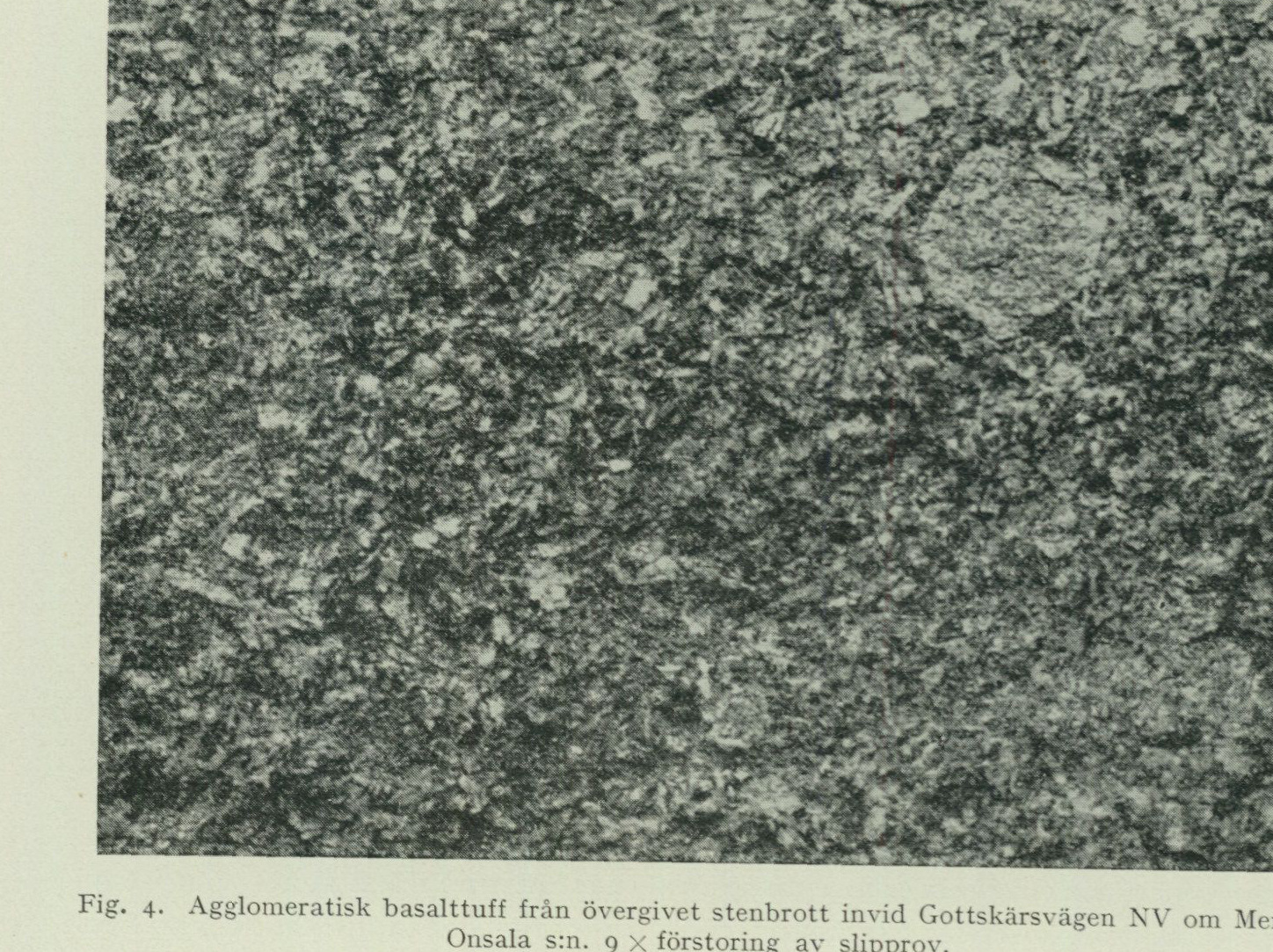
Fig. 4. Agglomeratic basalt tuff from an abandoned quarry next to Gottskärsvägen NW of Meryt. Onsala parish. 9× enlargement of specimen. C. Larsson photo 1950.
have also been carried out (tab. II, p. 21). According to this, the constituents of the Meryt tuff are considered magmatic first differentiates (see further p. 20 and the publications cited there in the footnote). The tuff contains numerous agglomeratic fragments, including slowly cooled basalt lava (diabase) with a fine-grained groundmass and well-developed lath-shaped (ophitic) plagioclase. This provides evidence that not only tuffs but also lavas are included in the surface formations of the Onsala peninsula. Sills of altered basalt have also been discernible at several localities in the amphibolite exposures of the map sheet, owing to the discordant contacts they display against their surroundings (tuffs or older lavas). A suitable subject for study is provided by the outcrops midway between Grunsen and Lerkil. The intrusive basalt occurs here as a slightly uralitized porphyrite, not altogether fine-grained amphibolite, whereas the older basic lava or tuff has been converted into an even and genuinely fine-grained amphibolite. Microscopic analysis of a diabase inclusion in the agglomeratic tuff NW of Meryt shows that a rather pronounced alteration has affected the rock after its original consolidation. Dark main minerals are thus serpentine (antigorite, chrysotile) and chlorite with relicts of anthophyllite and uralitic hornblende, as well as biotite and titanium-rich magnetite. The light main mineral, plagioclase, has on the whole retained its primary lath-shaped habit, but numerous newly formed, irregularly bounded (xenomorphic) individuals also occur. The latter are considerably more acidic, more albitic, than the old lath-shaped individuals. In this way the composition of the plagioclase as a whole will vary
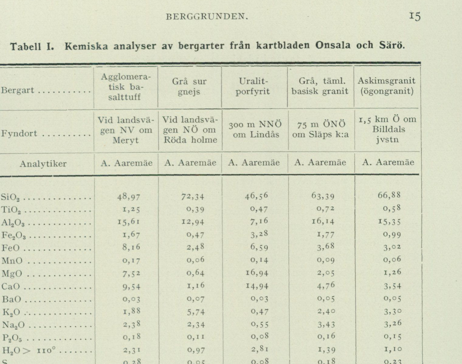
Table I. Chemical analyses of rocks from map sheets Onsala and Särö
| Constituent | Agglomeratic basalt tuff | Gray acidic gneiss | Uralite porphyrite | Gray, fairly basic granite | Askim granite (augen granite) |
|---|---|---|---|---|---|
| Locality | By the public road NW of Meryt | By the public road NE of Röda holme | 300 m NNE of Lindås | 75 m ENE of Släp Church | 1.5 km E of Billdal railway station |
| Analyst | A. Aaremäe | A. Aaremäe | A. Aaremäe | A. Aaremäe | A. Aaremäe |
| SiO₂ | 48.97 | 72.34 | 46.56 | 63.39 | 66.88 |
| TiO₂ | 1.25 | 0.39 | 0.47 | 0.72 | 0.58 |
| Al₂O₃ | 15.61 | 12.94 | 7.16 | 16.14 | 15.35 |
| Fe₂O₃ | 1.67 | 0.47 | 3.28 | 1.77 | 0.99 |
| FeO | 8.16 | 2.48 | 6.59 | 3.68 | 3.02 |
| MnO | 0.17 | 0.06 | 0.14 | 0.09 | 0.06 |
| MgO | 7.52 | 0.64 | 16.94 | 2.05 | 1.26 |
| CaO | 9.54 | 1.16 | 14.94 | 4.76 | 3.54 |
| BaO | 0.03 | 0.07 | 0.03 | 0.05 | 0.05 |
| K₂O | 1.88 | 5.74 | 0.47 | 2.40 | 3.30 |
| Na₂O | 2.38 | 2.34 | 0.55 | 3.43 | 3.26 |
| P₂O₅ | 0.18 | 0.11 | 0.08 | 0.16 | 0.15 |
| H₂O > 110° | 2.31 | 0.97 | 2.81 | 1.39 | 1.10 |
| S | 0.28 | 0.05 | 0.08 | 0.18 | 0.23 |
| F | 0.09 | 0.19 | 0.01 | 0.02 | 0.20 |
| H₂O < 110° | 0.18 | 0.08 | 0.11 | 0.14 | 0.14 |
| Sum | 100.22 | 100.03 | 100.22 | 100.37 | 100.11 |
| Less oxygen for S and F | 0.15 | 0.10 | 0.00 | 0.08 | 0.17 |
| Total | 100.07 | 99.93 | 100.22 | 100.29 | 99.94 |
from that of an andesine to that of an oligoclase-albite. Accessory minerals in the diabase are pyrite (secondary) as well as apatite and zoisite (small rods in the plagioclase, the latter newly formed). Phenocrysts of plagioclase occur here and there. The larger among these are tabular, the smaller more corroded and thus more irregular in outline. The tuff WSW of Forsbäck is also basaltic. It consists of alternating greyish-black and greyish-green, fine-grained layers containing agglomeratic rock fragments, probably basalt lava. Thin, unevenly distributed and often broken-up layers as well as more irregular portions, all consisting of labradorite with abundant admixture of epidote, have also been observed. The tuff and its inclusions show throughout a saccharoidal recrystallization texture (granoblastic texture). The greyish-green layers consist essentially of small grains of plagioclase (acidic labradorite) and augitic diallage (extinction c : y = 40–42°, optic axial angle 2Vγ about 60°) or of plagioclase (acidic labradorite), hornblende (common, green) and epidote, depending on the degree of alteration that has secondarily affected the rock. In addition, altered sphene grains occur abundantly. These are now filled with an amorphous, extremely finely dispersed ore-mineral dusted throughout
mass, which in isolated cases encloses larger ore grains. Apatite and zoisite (secondary) occur as small rods in the plagioclase.
Amphibolite. As already pointed out in the introduction, the greenstones separated out as surface rocks are generally amphibolitic. In the field they constitute fine-grained, grey-black or green-black metabasites composed of hornblende and plagioclase (oligoclase or andesine) together with subordinate amounts of quartz, biotite, sphene, ore (magnetite, titanomagnetite), and apatite. In microscopically examined thin sections, the hornblende shows a pale to moderate pleochroism in blue-green or brownish green, olive green or brownish green, and yellow to colourless, depending on which of the refractive-index axes the eye follows. The optic axial angle (2Vy) is usually 100—110°, the extinction (c : γ) 15—20°. In some places a cummingtonitic, in thin section almost colourless hornblende has also been observed. Locally the hornblende so dominates over the plagioclase that an ultrabasic, hornblenditic rock results. This is the case, for example, E and S of the tuff described above WSW of Forsbäck. Through secondary alteration at low temperature, hornblende and plagioclase have in many places been converted to epidote. Among other observed low-temperature minerals may be mentioned chlorite (penninite) and sericite. On the mainland immediately E of Onsala Sandö, occurrences of entirely epidotized, yellowish grass-green amphibolite have been observed.
Diorite. In other places the metabasites have been coarsened — made dioritic — through secondary heating (see further p. 22). Diorite formation appears to have required a relatively high temperature. Widely different fates have thus befallen different parts of the Onsala peninsula’s supracrustal formation, a truth that will become even more apparent when the gneisses are studied (see below). So great are the differences between certain parts of the supracrustal formation, in fact, that a subdivision of it into two groups appears justified. In the concluding chapter the reasons for such a subdivision will be discussed in greater detail. In many places the metabasites of the Onsala peninsula are bordered, veined, or split apart by acidic silicate material (fig. 5). Mostly this involves thin sheets of gneiss that have been secondarily remelted and mobilized to a greater or lesser extent, but veining produced by injection of pegmatite and aplite is also a common phenomenon. In the latter case the rock may be designated a basic veined gneiss (see further p. 35).
Gneisses.
The gneisses belonging to the supracrustal formation constitute a showcase of metamorphic, sugary rocks of varying acidity. Sedimentary fine layering can be observed in several places, and alternation with metabasites is the rule, if not on a small scale then at any rate on a large scale. Or expressed in other words: if gneiss and metabasite do not alternate within the same outcrop, they do so in the cross-sections through every larger, continuous part of the supracrustal formation.
Tuff, tuffite, Although lava components may occur also in the acidic members of the supracrustal lava. formation, the main part of these would rather be interpreted as tuffs and tuffites.¹ Pure ¹ Tuffs contaminated by weathered sedimentary material.
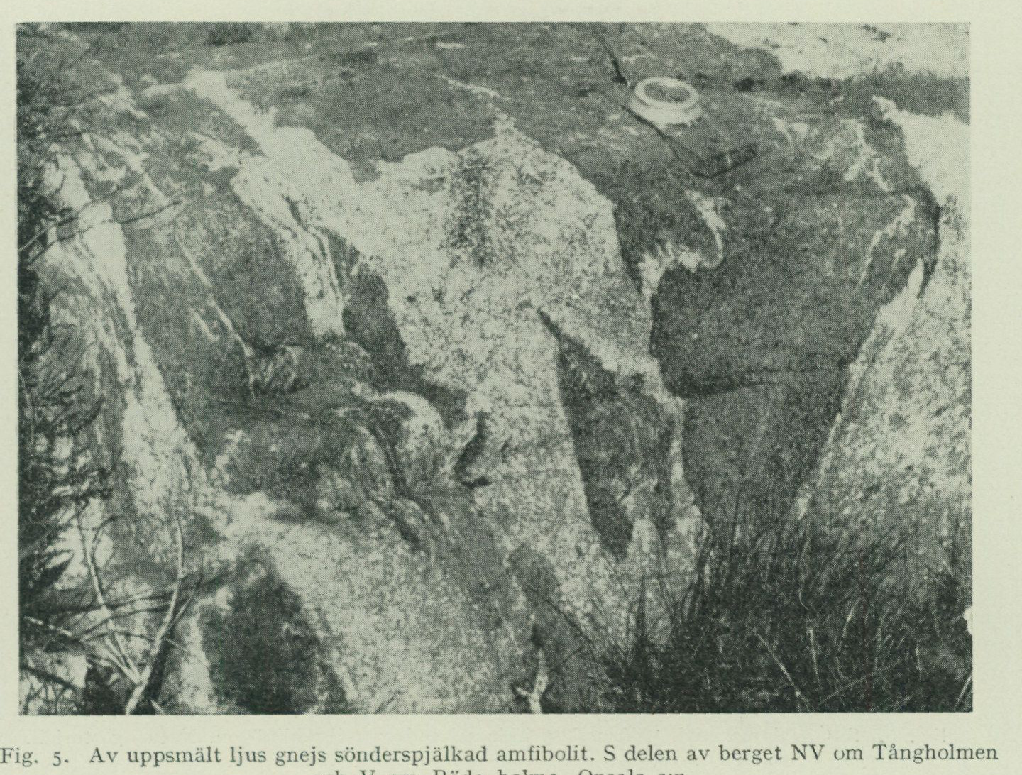
Fig. 5. Amphibolite split apart by remelted light gneiss. S part of the rock NW of Tångholmen and W of Röda holme, Onsala parish. P. H. Lundegårdh photo 1948.
weathering sediments appear to be less common. As lavas the author wishes to interpret certain of the hornblende-rich transitional forms to the proper metabasites. Preserved lava structures have not been observed in any of the peninsula’s gneisses. On the other hand, a tuff has been found enclosed in gneiss 1.5 to 2 km W of Forsbäck (fig. 6). The tuff is agglomeratic. It consists of a large number of now angular, Agglomerate. now rounded metabasite fragments (< 1 cm in cross-section) in an acidic, sporadically microcline-porphyritic and completely recrystallized, sugary groundmass. The microcline eyes have proven to be secondary. Quartzitic gneiss and quartzite, in all likelihood consisting of weathering Quartzite. products of older Precambrian basement, have been observed near the harbour at Gottskär. Minor intercalations also occur in several other places. The quartzitic gneisses of the Onsala peninsula show great petrographic similarities with the corresponding rocks in the leptite formation of Bergslagen. Other varieties of the peninsula’s gneisses may also sometimes assume a leptitic appearance. The grain of the gneisses is generally fine. Secondary microcline eyes or Proper veins of microcline and quartz occur, however, in many places. True veined gneiss — gneiss. gneiss veined by pegmatite (and aplite) — is abundant in the E and SE parts of the Onsala peninsula (see further p. 35). In many places the gneisses have been coarsened or even melted (fig. 5 and 10) through heating caused by the foldings and subsidences that affected the supracrustal formation after its formation. In such cases it is often not possible to distinguish the gneisses from intrusive granites and gneiss granites (see p. 31). Main-
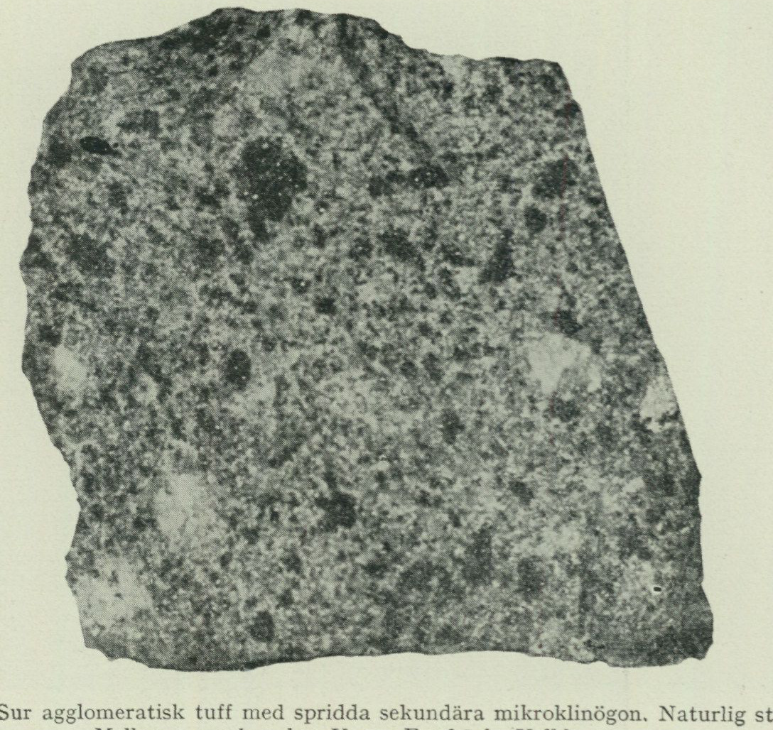
 Fig. 6.  Acid agglomeratic tuff with scattered secondary microcline eyes. Natural size.
                 Between 1.5 and 2 km W of Forsbäck, Vallda parish.
                                      C. Larsson photo 1949.
Most of these latter rocks probably also originate from gneisses remelted at depth. Even the pegmatite and aplite of the peninsula appear to a large extent to derive their origin from gneisses. The mineral composition of the gneisses reflects their degree of acidity. Thus, the basic varieties consist mainly of plagioclase, hornblende, and biotite. In addition, quartz occurs in essential quantities and titanite, ore (mostly magnetite), and apatite in smaller amounts. The acid types are characterized by progressively increasing contents of especially microcline but also quartz, while hornblende disappears and biotite together with plagioclase decrease in quantity, the latter often more than the former. However, microcline-rich basic gneisses have also been found, though more rarely acid and microcline-poor ones. In the former, one can observe how the microcline fingers out among and, as it were, displaces the other constituents. It arrived late, like an uninvited guest, and endeavoured to transform a metabasic rock into a granitic one. At the same time, in all probability, the quartz content also increased, while corresponding amounts of the original minerals were removed (metasomatism). A chemical analysis of a typical acid gneiss is found in Table I. The main minerals in this rock are quartz, microcline, and biotite; the subordinate mineral is plagioclase (oligoclase); the accessory minerals are ore (magnetite), titanite, epidote, muscovite + sericite, apatite, zircon, orthite, and garnet. A certain vein-gneiss formation can be discerned in the hand specimen (thin pegmatite layers).
A special position among the more acid gneisses of the peninsula is occupied by the muscovite-rich variety Two-mica- (the “two-mica gneiss”). As a whole, however, it is by no means as common as the gneiss. gneisses carrying only, or almost only, biotite. Nor has it been separated out on the maps accompanying this description, due to the difficulty of precisely determining its distribution. A good representative of two-mica gneiss, with equal amounts of biotite and muscovite, is found just over 1/3 km N—NNE of Skällared (NW of Meryt). The main minerals here are quartz, plagioclase (oligoclase), microcline, biotite, and muscovite, while titanite, ore, calcite, epidote, and zircon occur accessorily. The rock shows a division into lighter and darker layers. The former are salic and sometimes nearly quartzitic, whereas the latter are enriched in mica and titanite. The two-mica gneiss on the Onsala peninsula is petrographically and probably also genetically linked to the grey and often streaky two-mica gneisses in the Gothenburg archipelago.1 Quartzitic and mica-schist-like portions are included among the latter, while clay-derived minerals such as sillimanite and cordierite are absent. Nevertheless, the two-mica gneisses of the Gothenburg area must as a whole be interpreted as metamorphic derivatives of weathering sediments. ENE and E of Marstrand, as at Rörtången and Tjuvkil, they make room for pure sedimentary schists.
As already mentioned, the rocks of the surface formation are generally sugary- granular. Primary stratification has proven to be a general feature, whereas special characteristics of lavas and tuffs are found only locally. Secondary phenomena are, besides the recrystallization itself, the tectonic deformation (cf. the bedrock map), the partial remelting (see fig. 5 and 10 as well as p. 17), and the vein-gneiss formation (see p. 35). Already before the formation of the granite rocks described below, the surface Deformation of \ formation was affected by a powerful folding, which distorted the original, the surface series. evenly horizontal bedding of effusive rock and sediment. Not only were the layers uplifted or flexed downward, they were also in many cases crumpled. Deforma- tion of the latter type can, among other things, be studied in the hills W of Björkgläntan and SE of Hylte. After the formation of the deep-seated formation, the bedrock was affected by yet another de- formation, which created the schistosity and lineation so characteristic of parts of the Onsala peninsula (see fig. 7–8, 13–14, and 21–22). This deformation, which led to the formation of the vein gneisses and pegmatite rocks, followed mainly pre-existing structural planes in the bedrock.
Deep-seated formation.
The coarser greenstones and the more or less strongly gneissified granites, which together build up the greater part of the Onsala peninsula, generally show in their present state all the characteristics of a plutonic rock and should therefore be classified
1 H. E. Johansson: Berggrunden i Beskrivning till kartbladet Göteborg. S. G. U. Ser. Aa no.
173, Stockholm 1931. P. 25.
with the term deep formation. Strong bonds, however, link this deep formation with the above-described surface formation. The quartz diorites and diorites of the peninsula thus appear, in the majority of studied cases, to originate from the metabasites of the surface formation, and the main mass of granites reflect in their composition the gneisses of the surface formation with their amphibolite layers. What is more: precisely because amphibolite layers are so common in the gneisses, the granites appear to have become basic to such a large extent as is now actually the case (see the bedrock map as well as the chapter on the geological evolution).
Greenstones.
Oldest among the rocks of the deep formation are the uralite gabbro and its relatives. It is a rule in deep rock suites that basic greenstones initiate the eruptive activity. It is also a rule that the earliest greenstones are ultrabasic.
Ultrabasic greenstone. On the Onsala peninsula, ultrabasic greenstone occurs 300 m NNE of Lindås (small occurrence), 900 m NE of Mariedal (small occurrence), 600 m E–ESE of Mariedal (fairly small occurrence), between Hultet and Ledet WSW of Gottskär (somewhat larger massif) and on the mainland E adjacent to Onsala Sandö (very small occurrence). Chemical analysis has been performed on hand specimen material from the first-mentioned locality (tab. I). The analysis shows a remarkably high content of calcium. This condition, as well as the relatively high silica concentration for an ultrabasic rock, is probably due to the parent magma assimilating foreign rocks on its way upward in the earth’s crust.
The Lindås greenstone has also been subjected to partial trace element analysis (tab. II). The figures show the concentration relationship Cr > Ni > Co, which is typical for ultrabasic deep greenstones that have been intruded in connection with or shortly before foldings and have the character of magmatic first differentiates.^1 However, in such rocks one usually has to reckon with very considerably much larger contents of chromium than that found in the Lindås greenstone (150 g/ton).
Mineralogically, the Lindås greenstone consists of a pale pleochroic uralitic^2 hornblende, which has mainly formed from augite, further of preserved augite (usually as remnants in the hornblende), and of chlorite and biotite. Not insignificant amounts of sericite (likely plagioclase pseudomorphs) are also present. Accessory minerals are magnetite, pyrite, and titanite (rare). Upon microscopic examination of thin sections of the rock, the hornblende appears to be pale pleochroic in green to blue-green, olive-green, and greenish-yellow to colorless, depending on which of the axes of light refraction the eye follows. The optic axial angle is 90°. In the microscope, the augite shows an axial angle (2Vy) of approx. 65° and an extinction (c : y) of approx. 40°.
In hand specimens, the Lindås greenstone constitutes a uralite porphyrite, i.e., a greenish-black, massive rock with coarse to medium-sized, interpenetrating, secondary
^1 See P. H. Lundegårdh: Aspects to the Geochemistry and Petrology of Plutonic Ultra-Basites in Sweden, Geol. fören. i Stockholm forhandl, bd 72, 1950, as well as Geochemistry of Chromium, Cobalt, Nickel and Zinc, S. G. U., ser. C, n:o 513, Stockholm 1949. ^2 Uralite is hornblende that has formed through the alteration of pyroxene.
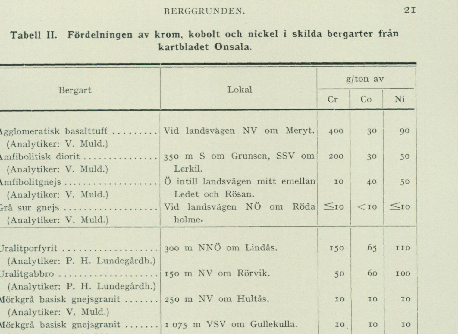
Table II. The distribution of chromium, cobalt, and nickel in various rock types from map sheet Onsala.
| Rock type | Locality | Cr | Co | Ni |
|---|---|---|---|---|
| g/tonne | ||||
| Agglomeratic basalt tuff (Analyst: V. Muld.) | At the main road NW of Meryt. | 400 | 30 | 90 |
| Amphibolitic diorite (Analyst: V. Muld.) | 350 m S of Grunsen, SSW of Lerkil. | 200 | 30 | 50 |
| Amphibolite gneiss (Analyst: V. Muld.) | E adjacent to the main road midway between Ledet and Rösan. | 10 | 40 | 50 |
| Gray acid gneiss (Analyst: V. Muld.) | At the main road NE of Röda holme. | ≤10 | <10 | ≤10 |
| Uralite porphyrite (Analyst: P. H. Lundegårdh.) | 300 m NNE of Lindås. | 150 | 65 | 110 |
| Uralite gabbro (Analyst: P. H. Lundegårdh.) | 150 m NW of Rörvik. | 50 | 60 | 100 |
| Dark-gray basic gneiss granite (Analyst: V. Muld.) | 250 m NW of Hultås. | 10 | 10 | 10 |
| Dark-gray basic gneiss granite (Analyst: V. Muld.) | 1 075 m WSW of Gullekulla. | 10 | 10 | 10 |
hornblende eyes in a fine medium- to fine-grained groundmass. The greenstone 600 m E-ESE of Mariedal is of similar character. However, it may be questioned whether olivine was not also originally present there, at least to some extent. The same can be suspected to be the case with the two remaining small occurrences, the one N of Mariedal and the one E adjacent to Onsala Sandö. At these two localities, the greenstone is an uneven-grained but not eye-structured hornblende rock. In the occurrences E adjacent to Onsala Sandö and E—ESE of Mariedal, the ultrabasic greenstone is veined by acidic, light silicate material.
In the massif between Hultet and Ledet, ultrabasic greenstone constitutes a more subordinate component. Uralite gabbro. Here, hornblende rock occurs together with uralite gabbro and diorite in the W part of the massif. To the E, uralite gabbro crops out, and to the N, uralite gabbro and diorite (cf. the bedrock map). The hornblende rock is usually green-black and uneven-grained, but can sometimes transition into small-grained amphibolitic forms. The uralite gabbro, the most important greenstone of the massif, is a gray-green-black to dark green-gray, fine- to medium-grained, massive rock, consisting essentially of uralite hornblende with rare remnants of clinopyroxene and of plagioclase (labradorite to bytownite). The latter mineral often forms slightly coarser, eye-like individuals. A common mineral in the uralite gabbro is also biotite. Accessory minerals occurring are epidote, pyrite, apatite, and magnetite. The plagioclase is often surprisingly fresh and clear, but on the other hand, can locally be strongly altered to sericite, saussurite, or clinozoisite. The diorite is similar to the uralite gabbro but more acidic, both as a whole and regarding the plagioclase. In the marginal parts of the gabbro massif, the diorite often assumes an amphibolitic character.
         Alterations of acidic silicate material occur rather abundantly in the northern part of the massif, out toward Ledet.
         Lralite gabbro is also found in the mountains \—N\ adjacent to Rörvik. The rock appears here as irregular and partly rather coarse patches in a diorite that often becomes amphibolitic (cf. the bedrock map). The Rörvik gabbro has been subjected to partial trace element analysis (tab. II). The values obtained classify the rock as a not excessively early magmatic differentiate, intermediate between early-magmatic and mean-magmatic greenstone.¹ Mineralogically, the Rörvik gabbro is characterized by a hornblende showing evidence of having originated from pyroxene and by a recrystallized, largely decalcified plagioclase (andesine secondary after labrador). In addition, non-insignificant amounts of epidote (cf. p. 24) and biotite occur. Accessory minerals include titanite (abundant) and ore.
Metagabbro. An interesting small occurrence of strongly altered gabbro, so-called metagabbro, has finally been discovered 400 m W of Rydet. We are dealing here with a fine- to medium-grained, originally almost wholly medium-grained rock, which is handsomely mottled in grey-green-black and in white with a tendency toward pinkish or green. The two types of fields are partly bounded by idiomorphic contours.² Judging from their shape and present mineral content, the dark fields were once constituted by pyroxene, while the light ones consisted of plagioclase. One now finds a mass of sericite and saussurite with numerous somewhat larger epidote individuals in the places of the plagioclase grains, and a mixture of common green hornblende, green-pleochroic chlorite (main constituents) together with epidote, magnetite and pyrite in the places of the presumed pyroxene grains. Not inconsiderable amounts of quartz have entered the rock during the alteration. The quartz forms partly veins, partly patterns of granoblastic small grains in the hornblende. Of primary minor minerals, titanite and apatite have been observed. In addition, some biotite occurs in the rock.
The metagabbro W of Rydet passes gradationally into dioritic-amphibolitic rocks, which to the E and W border against gneissic augite granite. On the bedrock map, owing to the scale, the extent of the metagabbro has been exaggerated, though naturally with the starting point from the locality where the gabbro was encountered.
Diorite, quartz- The diorites and quartz diorites of the Onsala peninsula appear to consist essentially of diorite. altered basic members of the supracrustal formation. This assumption is based partly on their positions relative to undoubted supracrustal greenstones (see the bedrock map), partly on the numerous transitions that exist between supracrustal greenstones and diorites, and partly, finally, on the abundant content of elongated and mutually parallel supracrustal greenstone fragments that often characterize especially the quartz-dioritic varieties (see further below).
    If what has now been stated is correct, the diorites and quartz diorites of the Onsala peninsula should reflect specific characteristic features of the supracrustal rocks from which they originated. Where the original supracrustal rock constituted an early magmatic differentiate (see p. 20), the resulting plutonic rock should accordingly possess a composition corresponding to this. One should consequently be able to find

                   ¹ See the publications cited in the footnote on p. 20.
                     ² Contours determined by the crystal forms of the original minerals.
secondary diorites with the same relationship between the trace elements chromium, cobalt and nickel as that which characterizes, for example, the basalt tuff NW of Meryt (Cr > Ni > Co; see tab. II). This has also proven to be the case (see the diorite analysis reproduced in tab. II).
Primary diorites appear to occur only in association with the gabbro types described above. This kind of diorites are grey-black, green-black-grey or dark grey, fine- to medium-grained rocks, which for the most part consist of hornblende (partly distinctly uralitic: secondary after pyroxene) and strongly corroded plagioclase (andesine). Epidote is often abundant. Accessory minerals are titanite, titanomagnetite and apatite. In addition, pyrite occurs in several places. Regarding the origin of the epidote, reference is made to p. 24.
The diorites and quartz diorites (of which the latter predominate) linked to the basic member of the supracrustal formation are, as the bedrock map shows, concentrated at Råö and the surrounding area. They constitute dark grey to black-grey, usually massive, fine- to medium-grained plagioclase-hornblende rocks with greater or lesser contents of quartz, biotite and epidote. Accessory minerals include apatite, pyrite, ore (magnetite, partly titanium-bearing), often titanite and sometimes also orthite. The plagioclase is an andesine. The hornblende shows, in microscopically examined thin sections, a medium-strong pleochroism in blue-green, olive-green, and weakly green-yellow to yellow, depending on which of the refractive index axes is in question. The optic axial angle (2Vy) lies around or slightly above 100°.
The quartz diorite not infrequently grades into a dark, basic, mostly gneissic granite, which sometimes contains pink microcline eyes (see p. 24). Conversely, one also finds in several places bodies of quartz diorite within the basic gneiss granite of the Onsala peninsula. On the headland S of the triangulation point Fjärhals (W of Råö), a rock oscillating between basic gneiss granite and quartz diorite grades, under increasing primary schistosity, in places into mafic gneiss with numerous partly dismembered amphibolite sheets. Similar phenomena can be studied NE of the aforementioned triangulation point. There is thus reason to assume that the quartz diorite and the basic gneiss granite in the vicinity of Råö originated through strong heating and the ensuing recrystallization of a mafic to amphibolitic gneiss. The most basic, formerly basaltic layers in the gneiss have evidently been torn apart through displacements along the schistosity planes during the folding that preceded the transformation of the gneiss into quartz dioritic rocks. The basalt subsequently withstood the heating, which aimed at transformations, better than the surrounding gneiss, but appears, on the other hand, to have been fragmented at this time into even more and even smaller pieces. Although it has preserved its basic character and its fine grain, the basalt is throughout amphibolitized and saccharoidal. Primary features similar to those previously described from another part of the Onsala peninsula (p. 14) are entirely absent.
Granites, gneiss granites.
The granitic rocks belonging to the plutonic formation of the Onsala peninsula can be divided into four main types: 1. black-grey to dark grey, basic, hornblende-rich,
often quartz-dioritic, usually slightly gneissic granite, 2. red-grey to grey, intermediate, usually slightly gneissic granite, 3. red-grey to red, intermediate to acidic, gneissic gra nite, and 4. grey-red to dark red-grey, usually intermediate, coarsely microcline-por phyritic, most often strongly gneissic granite. The aforementioned gneissic character is tectonically controlled and manifests itself both as planar schistosity and as streakiness. The intensity of the gneissification is highly variable. The streakiness in particular can suddenly and entirely locally become intense (cf. fig. 8 and 13).
The most common among the granites and gneiss granites (= gneissified granites) of the Onsala peninsula are the coarsely microcline-porphyritic ones. Next follow the basic varieties, and in third place the intermediate ones (see the bedrock map).
Basic rocks. The basic granites and gneiss granites are concentrated in the central part of the Onsala peninsula. There they have been developed as black-grey to dark grey, fine- to medium-grained, in places massive but more often deformation-gneissic rocks, which essentially consist of plagioclase, quartz, biotite (with some chlorite), hornblende, and epidote. The latter mineral has formed secondarily, principally through reaction between plagioclase and hornblende. In some places epidote has strongly displaced the hornblende. The plagioclase is an andesine or an oligoclase (the latter in all probability formed from the former through decalcification and epidote formation). A certain primary tabular habit characterizes the larger plagioclase individuals. The plagioclase is usually present in greater quantity than the other main minerals of the rock. A quantitative relationship observed in several collected samples is: plagioclase > quartz > biotite > hornblende > epidote.
The biotite shows, in microscopically examined thin sections, a greenish-brown pleo chroism. The hornblende is moderately or rather strongly pleochroic in blue-green, olive-green, and green-yellow, depending on which of the three principal refractive-index directions the eye follows.
Among the accessory minerals have been observed sphene, ore (magnetite and titanomagnetite), and apatite. More sporadically occurring are microcline, pyrite, zircon, and orthite. The microcline as a rule forms augen. The mineral has, in all examined cases, been found to displace the other constituents of the rock. It is, as one is accustomed to say, interstitial, and has certainly not been present from the beginning.
The microscopic overall picture of the basic gneiss granites of the Onsala peninsula, as they usually appear, is characterized by larger but often fractured mineral individuals, especially plagioclase, in a crushed mass formed during gneissification, consisting of secondarily recrystallized, saccharoidal quartz and plagioclase together with more irregularly shaped individuals or groups of individuals of the femic minerals. The epidote partly forms beautifully idiomorphic, rod-shaped small individuals, which not only occur between the other minerals or together with the biotite, but also readily as swarms inside the decalcified plagioclase.
The basic granites are distinguished from the gneiss granites by their massive primary structure. They are encountered here and there in protected positions within the mass of granite rocks. Under increasing gneissification they pass gradually into surrounding gneiss granites.
A chemical analysis (table I) has been carried out on a rather basic plagioclase granite from Släp church in the area N of the Onsala peninsula, within the geological map sheet
Särö. The analysed rock is characterised by a plagioclase that has been deprived of part of its lime. During the epidote formation that took place in connection with the decalcification of the plagioclase, all hornblende has been consumed. The mineral relationship is now: plagioclase (20 % An) > quartz > biotite > epidote > titanite 3> apatite > pyrite (the three latter constituting accessory minerals).
The more acidic, weakly or non-porphyritic granite rocks show the same crush structure as the basic ones, but are lighter. The colour varies between grey and red, with Acidic granite predominance of reddish-grey tones. Hornblende is generally absent. In its place, rocks, microcline has appeared among the main minerals. Otherwise, the more acidic, weakly or non-porphyritic granite rocks consist essentially of quartz, plagioclase and biotite. The latter mineral is quantitatively usually in fourth place. It has sometimes undergone partial chloritisation. Not insignificant amounts of epidote generally occur as well. As accessories appear titanite, muscovite, apatite, ore (magnetite, partly titaniferous), zircon and orthite, of which the two latter must be considered rare. The microcline readily forms large intergrown individuals in the otherwise fine- to medium-grained rocks, and in this way mediates transitions to the coarsely microcline-porphyritic varieties that will be described in the following. The plagioclase, an oligoclase, is often strongly sericitised and, in addition, often lightly impregnated with microscopic grains of hematite. These grains give the mineral a reddish colour tone. Clusters of small epidote prisms are not uncommon. They indicate that a certain decalcification of the plagioclase has taken place after the formation of the rock. The biotite shows, in microscopically studied thin sections, pleochroism from brownish-green to greenish-brown. Epidote occurs partly within the plagioclase (see above), partly together with the biotite, and partly separately among the salic mineral individuals. As a rule, the more acidic, weakly or non-porphyritic granite rocks are gneissified. One finds either the same type of crush texture already described for the basic gneiss granites (p. 24) or else a more pronounced zonal deformation: layers of largely primary but often fractured mineral individuals alternating with layers essentially composed of crushed grains (now generally rounded as a result of recrystallisation). This latter type of gneissification is characteristic of rocks where gliding has taken place along schistosity planes. Accordingly, one finds the type best developed adjacent to fracture surfaces along which displacements of one bedrock block relative to another have taken place. Phenomena connected with the gneissification further include subdivision of originally uniform quartz individuals into differently oriented sub-individuals, as well as bending of individual tabular plagioclase crystals.
As has already been indicated, the most common among the gneissic granite Coarsely rocks of the Onsala peninsula are the coarsely microcline-porphyritic porphyritic varieties. These types share the greyish-white or red microcline eyes, but granite rocks can otherwise vary quite considerably from one locality to another. There are eye granites with an acidic groundmass,
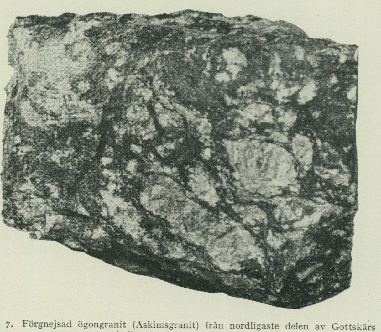
  Fig. 7. Gneissic eye granite (Askim granite) from the northernmost part of Gottskär settlement, Onsala parish. Scale 1 : 1.5.
                                      C. Larsson photo 1950.
and there are such with an intermediate or even fairly basic groundmass. There are easily gneissified eye granites, and there are such that have been pressed so strongly that the feldspar eyes have been crushed. The effect of gneissification on the texture of the eye granites is partly the same as in the non-porphyritic, more acidic granite varieties (see above). A more detailed textural analysis of the strongly schistose eye granite along the east coast of the Onsala peninsula will be given in the following. After the, to some extent, genuinely massive but otherwise similar eye granite that occurs in Askims parish just S of Göteborg, the eye gneiss granites of the Onsala peninsula have been summarised under the designation gneissic Askim granite. A chemical analysis of massive Askim granite from the area E of Billdal (on the map sheet Särö) has been reproduced in tab. I. The main minerals in the analysed sample are plagioclase, microcline,¹ quartz and biotite (together with some chlorite). Not insignificant amounts of epidote (with clinozoisite) and titanite also occur. As accessory minerals one may count apatite and ore, while zircon and muscovite occur more sporadically. The main minerals in the gneissic eye granites of the Onsala peninsula are the same: microcline,¹ quartz, plagioclase and biotite with chlorite. The alteration mineral epidote is also abundantly represented. Where the schistosity is intense, serpentine may also be found. As accessory minerals appear titanite, apatite and, sometimes, ore (magnetite, titanomagnetite). Orthite is more rare.
1 Generally perthitic. See the footnote on p. 29.
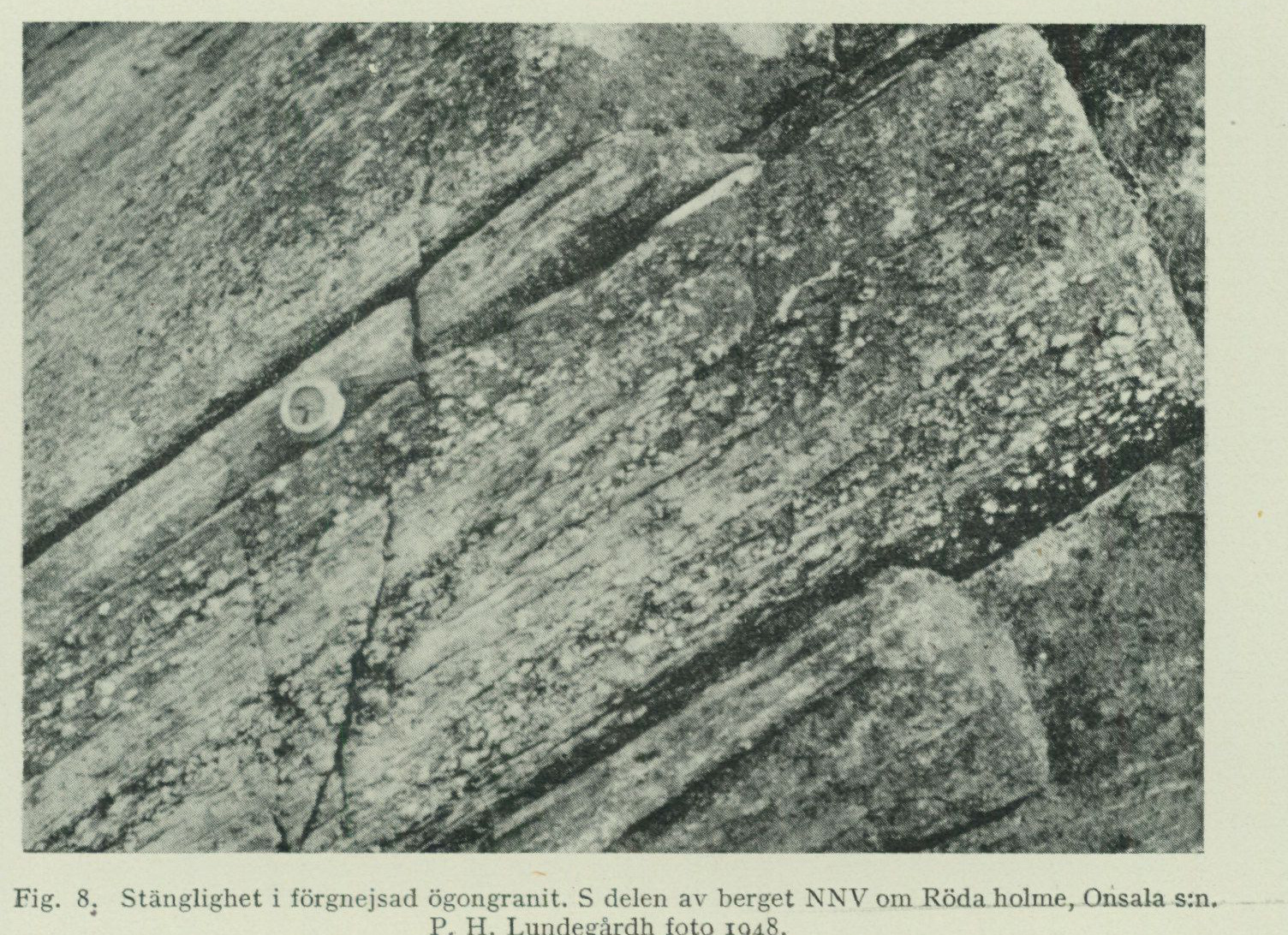
Fig. 8. Banding in gneissified augen granite. S part of the hill NNW of Röda holme, Onsala parish. P. H. Lundegårdh photo 1948.
The augen granites of the Onsala peninsula reach their greatest extent in and immediately W of Kungsbackafjorden. Here, too, the gneissification is on the whole most intense. The fjord area itself has been particularly affected, as a study of the bedrock of the islands provides ample evidence. On Hällesö, for example, most of the microcline augen have been crushed and drawn out. The entire former augen granite makes a distorted impression. Along the schistosity run both bands and veins of quartz and, above all, microcline. The gneiss granite occurring along and off the eastern side of the Onsala peninsula is a grey-red to dark red-grey rock with partly rectangular mi- crocline augen, whose length varies between 1/2 and 8 cm (fig. 7). The largest augen have been observed N of Krokudden and in the northernmost part of Gottskär. Besides microcline, there are also augen of yellowish, more or less strongly altered plagioclase. These augen, however, nowhere reach up to 1 cm in cross-section and thus cannot at all match the main portion of the microcline augen in size. The various augen lie in a groundmass that is for the most part fine-grained, which is now partly saccharoidal as a result of recrystallization (es- pecially as regards the quartz). Zones with very intense crushing, indicating former displacement planes, occur in many places and especially abundantly on the islands in Kungsbackafjorden (cf. above). The crushed mass is often conspicuously dark due to an originally rich biotite content in the rock and because the biotite along with its alteration minerals has been squeezed out into numerous, black, thinly winding layers during gneissification (fig. 7).
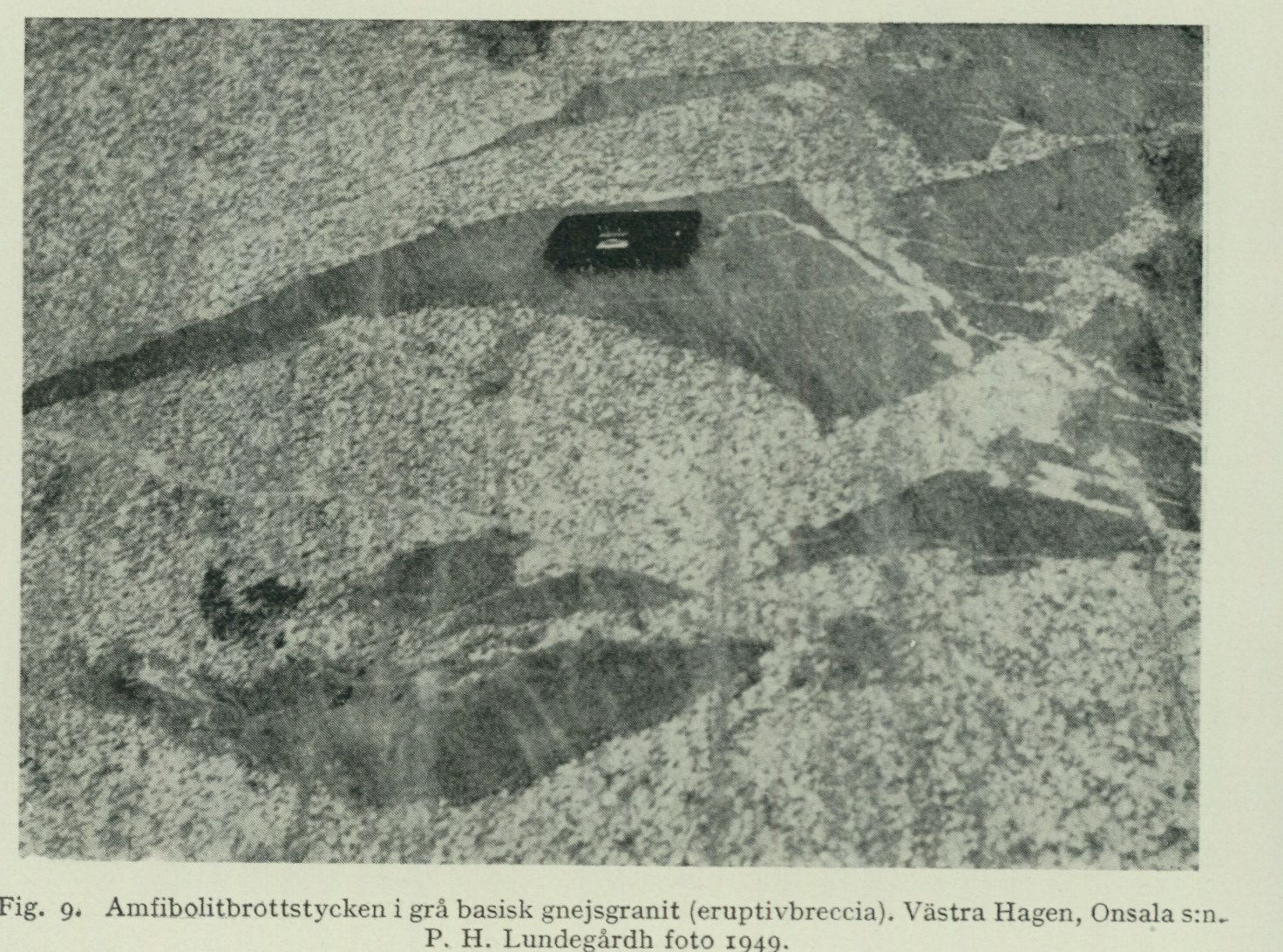
Fig. 9. Amphibolite fragments in grey basic gneiss granite (eruptive breccia). Västra Hagen, Onsala parish. P. H. Lundegårdh photo 1949.
The manner in which the various minerals occur in the strongly schistose augen granite of Kungsbackafjorden is best illustrated by the following description, which refers to thin sections of the very coarsely porphyritic gneiss granite in the northernmost part of Gottskär (see also fig. 7). Here one is perhaps first struck by the subdivision of the groundmass into long glide-crush zones, which, with local deviations (around the feldspar augen), run in the plane of schistosity. The dark layers of the crush zones consist of a confused mixture of, firstly, dirty-green, pleochroic biotite with secondary, dirty-green chlorite and serpentine (all mixed with ore dust), and, secondly, secondary epidote together with more sparsely scattered, mostly granoblastic quartz grains. The light layers of the crush zones are built up of saccharoidal quartz along with sparsely occurring, irregularly bounded albite individuals. The ore dust mentioned above in parentheses has completely obscured the densest of the femic crush-zone layers and rendered these pitch-black in the hand specimens. Between and within the crush zones lie the augen, around which the crush zones, as indicated above, as a rule bend around. However, there are also augen whose appearance shows that they must have grown after the schistosity planes were developed. These augen have replaced parts of the gneiss granite and thus interrupt the schistosity. They are of the greatest petrological significance, since they must have formed at a remarkably low temperature. Any more significant heating after the conclusion of the gneissification would indeed inevitably have led to a complete recrystallization of the rock. In such a case, the crush structures described above would have been entirely absent from the rock.
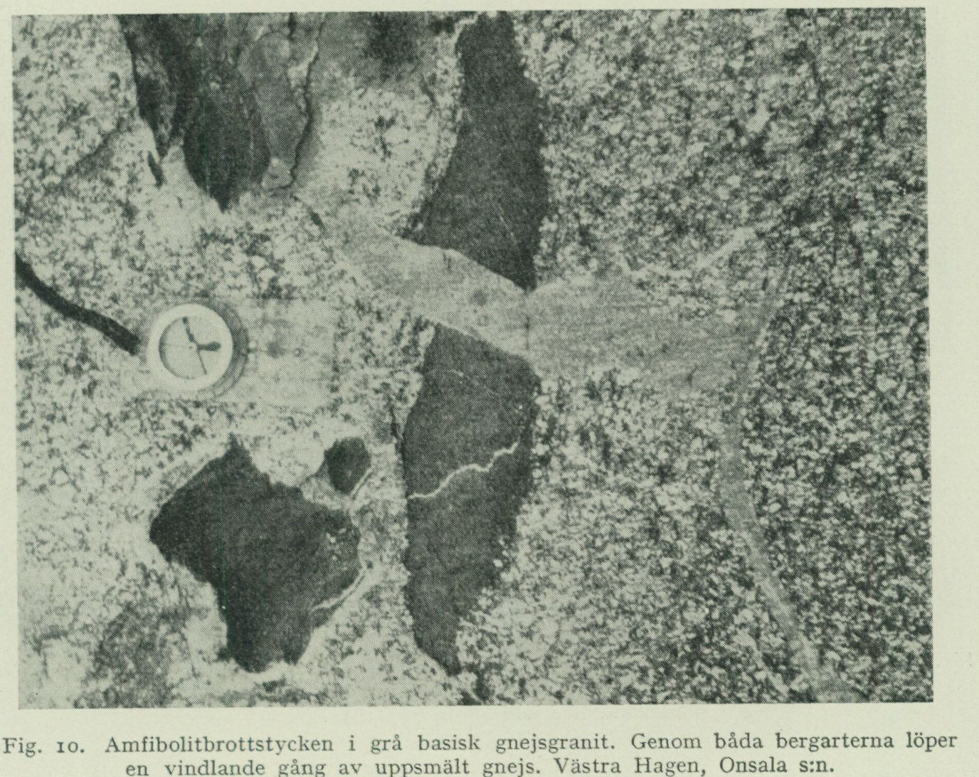
Fig. 10. Amphibolite fragments in grey basic gneiss granite. Through both rocks runs a winding vein of remelted gneiss. Västra Hagen, Onsala parish. P. H. Lundegårdh photo 1951.
Many of the feldspar augen were fractured during the gneissification and are now traversed by veins of biotite, chlorite, sericite, etc. The largest augen consist, as already mentioned, of microcline (perthitic¹). They not infrequently contain albite fragments, which suggests a later time of formation in relation to the other minerals of the rock. The medium-sized and smaller augen consist partly of microcline, partly of albite. The microcline is sparsely impregnated with hematite. The red colour is due to this. The albite is usually speckled with small, differently oriented, partly idiomorphic (rod- shaped) epidote individuals. This applies especially to the augen, which as a rule contain quantities of epidote grains. The epidote has formed through decalcification of the original plagioclase mineral, probably an oligoclase-andesine. In the albite, sericite flakes are also abundantly encountered. A specimen of augen gneiss granite taken at the base of Hållsundsudde, 1½ km NW of Krokudden, contains remnants of the original plagioclase, which has proved to be either an oligoclase-andesine or an acid andesine. Otherwise, the rock NW of Krokudden is similar to that described above, although the schistosity has not progressed as far as to the development of glide-crush zones. The crushed mass between the augen therefore does not show any complete layer subdivision. However, the individual bio- tite grains have been aligned in the plane of schistosity. Another sign of lower re-
1 Perthitization means a secondary separation of plagioclase dissolved in the microcline in such a
way that the plagioclase can be observed as a system of mutually crossing streaks in the microcline. Perthitization occurs generally in the microcline individuals of the Onsala peninsula, especially in the larger ones — those that form augen.
                                                    *    i.                           W ^

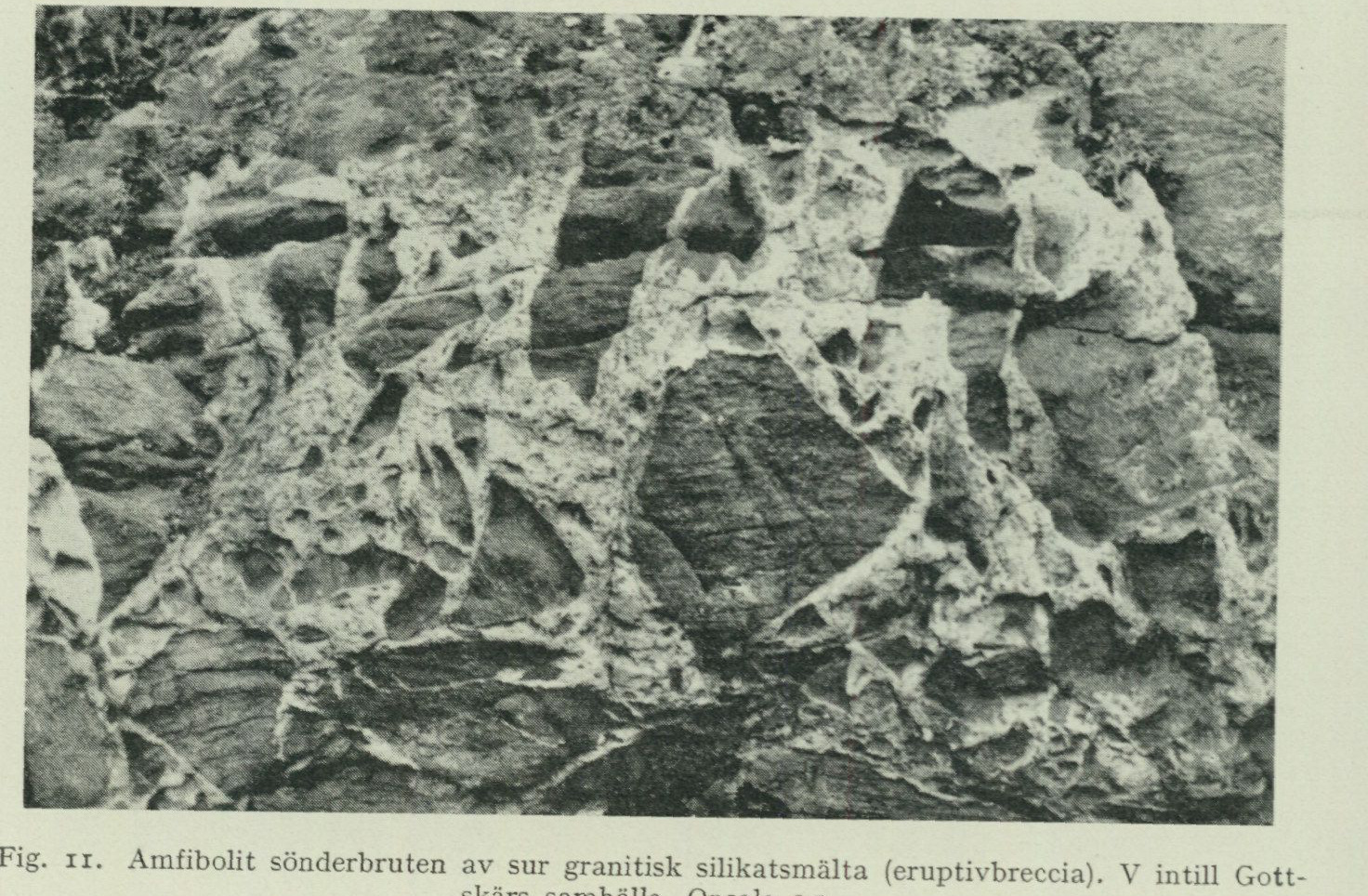
            Fig. 11.  Amphibolite broken up by acidic granitic silicate melt (eruptive breccia). W adjacent to Gott-
                                             skär settlement, Onsala parish.
                                                 P. H. Lundegårdh photo 1948.

       A measure of the degree of alteration is the colour of the biotite. While the mineral in the Gottskär rock
       shows dirty-green pleochroism, in the specimen from the rocks NW of Krokudden it is pleochroic
         in brown to green-brown.
         The eye-granites farther west on the Onsala peninsula differ from the variety now
       described in that the microcline eyes are on average smaller and that the gneissification is not always as strong. Striking, however, is
         the exceedingly strong augen structure that has been imposed on
        the more westerly eye-granites in tectonically exposed settings (fig. 8 and 13).
Granite rocks As has already been mentioned (p. 23), the basic granites and and their origin. the gneiss-granites in many places connect via transitions to purely quartz-dioritic rocks. In contrast to what is usually the case with the quartz-diorites, however, both the basic and the more acidic granites and gneiss-granites brecciate the rocks of the surface formation in several places in such a manner that no doubt can remain about their intrusive character. Such irregular, puzzle-piece breccias as those depicted in fig. 9—11 could presumably not have been produced by any natural force other than an advancing sili- cate melt. As the bedrock map shows, there occur not only small but also larger, indeed sometimes very large fragments of surface-formation rock within the granites and gneiss-granites of the Onsala peninsula. Moreover, it is evident from the map that the granite rocks in many places have cut through the more coherent portions of the surface formation that are still preserved. Locally they have also intruded into the greenstones of the deep formation. The impregnations constitute veins, bands, and streaks. The veins are fairly straight and most often follow the planes of schistosity, while the bands tend to wind
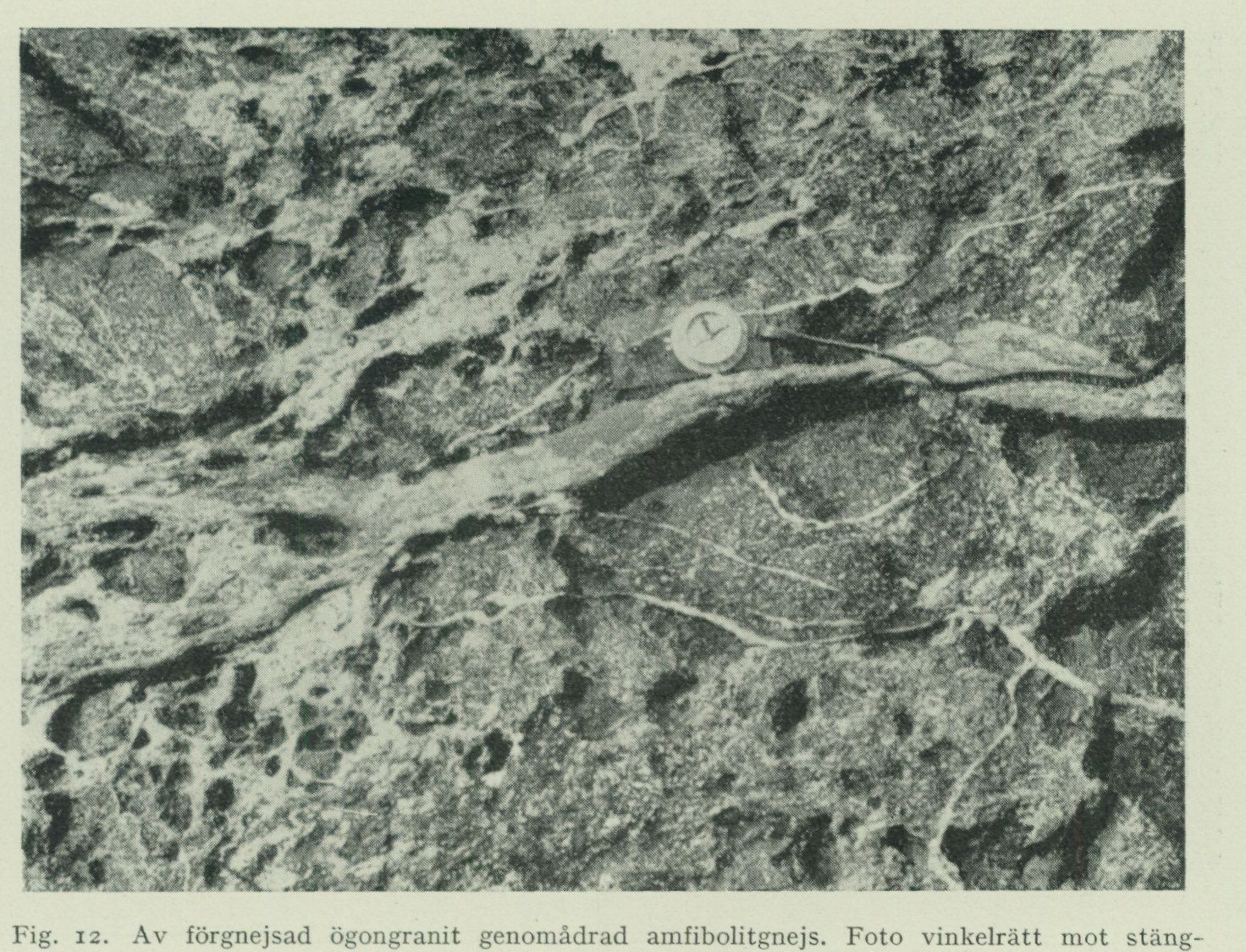
Fig. 12. Amphibolite gneiss veined by gneissified eye-granite. Photo perpendicular to the augen structure (cf. fig. 13). S part of the rock NNW of Röda holme. P. H. Lundegårdh photo 1948.
and the streaks run more or less irregularly. For this reason two kinds of symbols have been used on the bedrock map, one for veins, another for bands and streaks. The latter often permeate the rocks like a network (fig. 12). The relationship between the intruded rock and the intruding rock is in many places intimate. Particularly at the base of the peninsula, west of Lunnaled and in the vicinity of Ängås, one can, through a careful study of the field conditions, obtain evidence that much of the granites and gneiss-granites is nothing other than remelted gneiss that has moved and then solidified anew. Elsewhere, as at and NNW of Bassås not far from Råö, further evidence is provided for a close affinity between gneiss and gneiss-granite. Thus the rock NW—NNW adjacent to Bassås consists of an inhomogeneous, usually streaky, on average intermediate gneiss, which in many places passes gradually into a mobilised, granitised gneiss, the latter sometimes developed as coarsely microcline-porphyritic gneiss-granite of the type of gneissified Askimsgranite (cf. p. 26). SSE of the rock at Bassås, among acidic rocks only eye-gneiss-granite is exposed. NNW of the rock, the gneiss passes, with increasing coarsening, gradually into eye-gneiss-granite. What has just been said not only provides proof of secondary granite formation, it also leads the geologist into the question of how the eyes of the microcline-porphyritic granite rocks originated. It has already been pointed out (p. 24 and 28) that
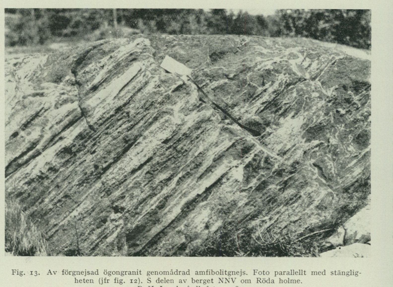
Fig. 13. Amphibolite gneiss veined by gneissified eye-granite. Photo parallel to the augen structure (cf. fig. 12). S part of the rock NNW of Röda holme. P. H. Lundegårdh photo 1948.
the granites and gneiss-granites locally contain intergrown, secondary microcline eyes. These eyes appear to have formed through material transport along weakness surfaces, either in connection with a secondary reheating of the bed- rock or, if the granite is intrusive, before the granite body had cooled after its original solidification. The material transport appears to have taken place by means of solutions. Primary constituents in the rocks subjected to secondary eye formation have in places been dissolved out, and newly supplied potash feldspar has crystallised in return. Sparse finds of small veins of acidic, pink aplite in partially eye-structured basic granite rocks (inter alia in the vicinity of Släp church on the Särö sheet) bear witness that mobile solutions rich in potassium-aluminium silicate did indeed exist. In contrast to the rocks they intrude, these small veins are massive. The gneissification of the granite rocks would thus, at least in part, precede the eye formation in time. It has also already been pointed out (p. 28) that certain of the eyes in the microcline-porphyritic gneiss-granite in the vicinity of Kungsbackafjorden are post-tectonic. On the other hand, however, it has been emphasised that the greater part of the microcline eyes in the fjord area have been affected by the schistosity. One may thus not reckon with any more extensive eye formation of post-tectonic age, either around or within the Onsala land area. Starting from a line of reasoning such as the one just pursued, to seek to prove that the microcline-porphyritic rocks of the Onsala peninsula in general would
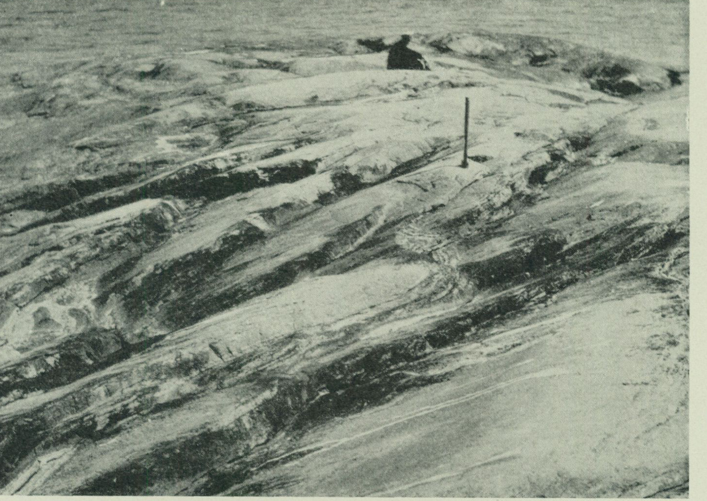
Fig. 14. Aplite granite-streaked gneiss interbedded with schistose augen gneiss granite along the schistosity plane characterized by a beautiful flaggy structure. Norra Ledskär, Värö parish.
                                 P. H. Lundegårdh photo 1950.
have acquired their augen secondarily, cannot, however, be done. The field evidence for a more general assessment of the issue of the origin of the microcline augen is still too scarce and vague.
Pegmatite, aplite, vein gneisses.
While the various rocks described in the foregoing have, as a rule, been more or less intensely deformed or mineralogically altered after their formation, the pegmatite and aplite of the Onsala peninsula show no or only insignificant signs of tectonic changes. They also constitute — with the exception of a single diabase dyke — the final link in the chain of processes that created the distinctive bedrock of the Onsala peninsula.
 The pegmatite and the aplite most often occur as dykes and as veins or Pegmatite,
streaks. But in some places, they accumulate into elongated bodies of considerable aplite
extent. By far the most important of the two rocks is the coarse pegmatite, while the saccharoidal aplite generally has the character of a subordinate associate rock. The colour of the pegmatite varies from purely greyish-white to reddish-greyish-white. More distinctly red tones occur on Öckerö, Hållsundsudde, and the islands in Kungsbackafjorden, as well as to some extent also on Örmanäs. The main minerals are white
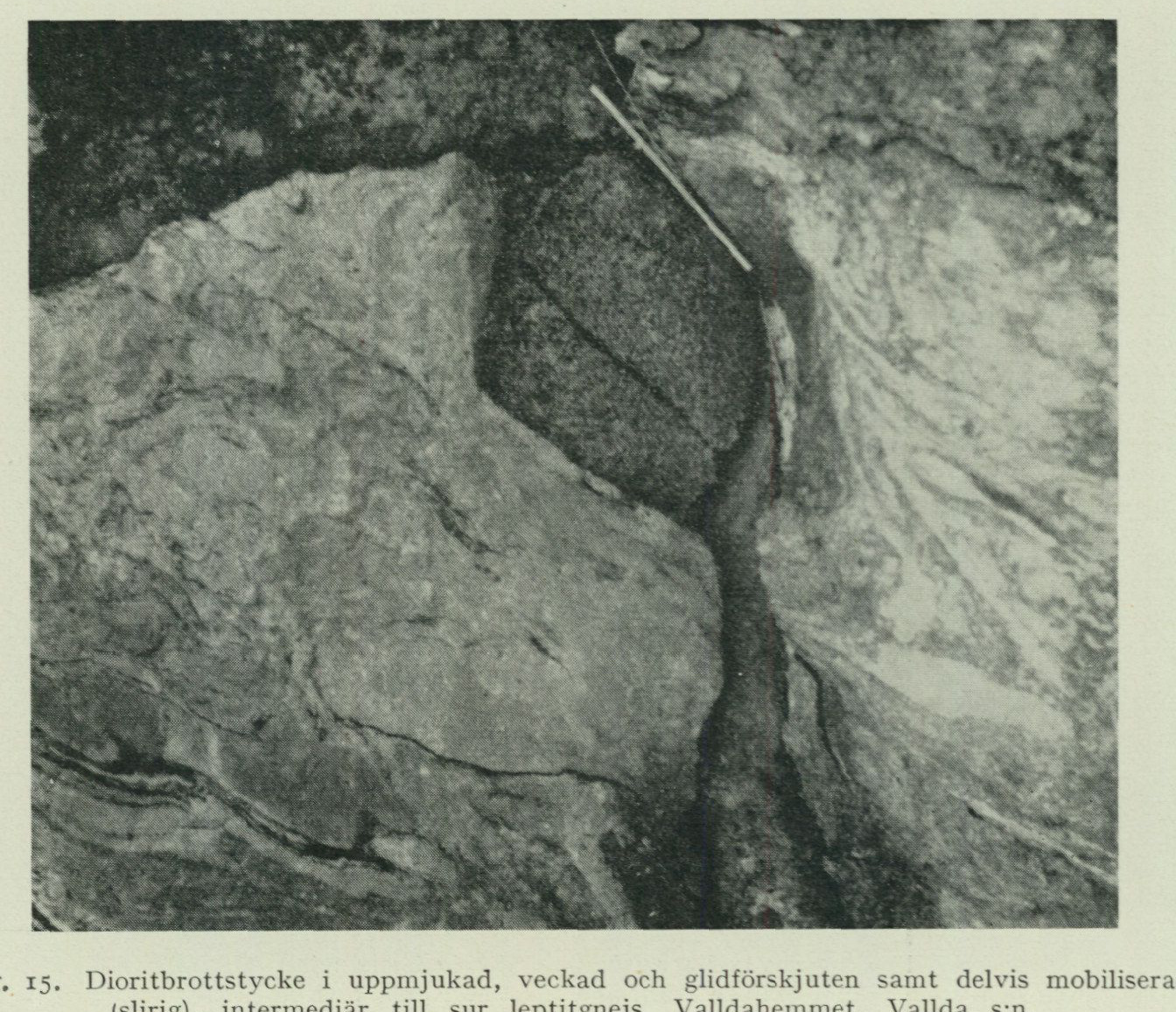
Fig. 15. Diorite fragment in softened, folded and glidingly displaced and partly mobilized (streaked), intermediate to acid leptite gneiss. Valldahemmet, Vallda parish. P. H. Lundegårdh photo 1949.
oligoclase, white to pink or red microcline, and grey quartz. In addition, minor amounts of mica are usually present. Red-violet garnet occurs accessorily. The aplite is pink, white, or greyish-white. It usually shows a fine-grained texture, but in places it becomes coarser and granitic. The aplite consists of the same minerals as the pegmatite. Both rocks are considered to have crystallized from hot, water-rich silicate solutions, the pegmatite slowly, the aplite rapidly. The aplite formation marks the end of the crystallization process, i. e. the point in time when the existence of the parent solutions was no longer permitted by the prevailing concentration, pressure, and temperature conditions. As shown by the bedrock map, the pegmatite and aplite are not evenly distributed over the Onsala peninsula but are concentrated to the coastal areas and the islands off them, while they are generally absent inland. Pegmatite occurs particularly abundantly W—SSW of Gottskär. Between Rösan and Vessingsö runs a zone, within which pegmatite dominates. Otherwise, the rock here consists of gneiss traversed by pegmatite veins (vein gneiss; see below). Aplite (medium- to fine medium-grained, granitic) outcrops in larger quantities E—ENE adjacent to Lerkil. The pegmatite is nowhere worth quarrying. Where it accumulates into larger, continuous zones, it is mostly contaminated with gneiss residues. The feldspar individuals do not reach the size and purity required for industrial purposes either.
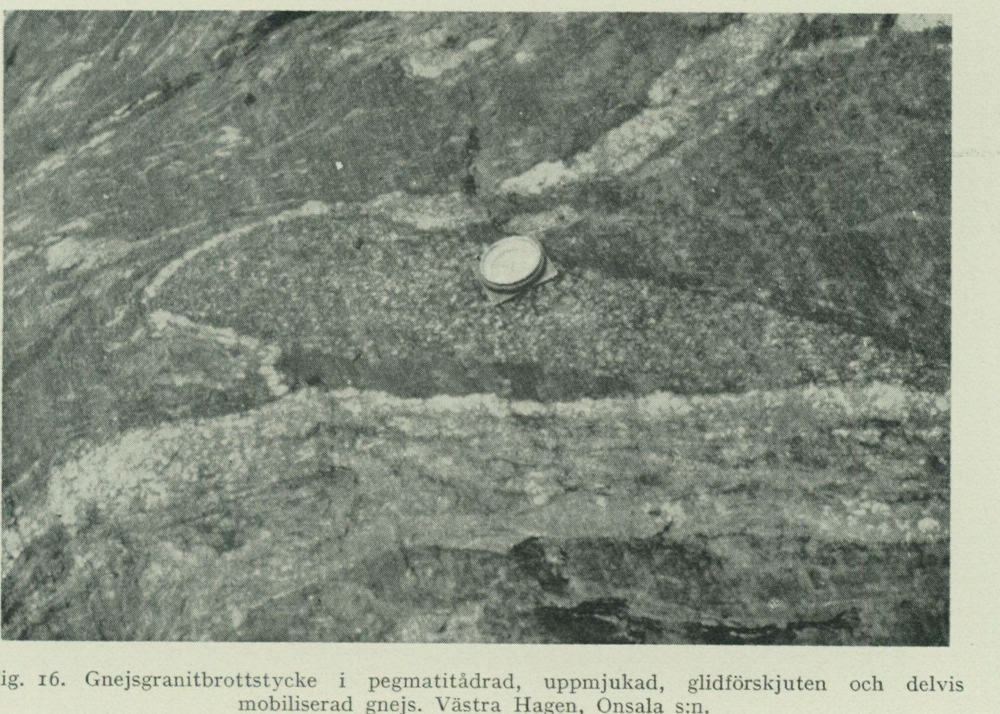
Fig. 16. Gneiss granite fragment in pegmatite-veined, softened, glidingly displaced and partly mobilized gneiss. Västra Hagen, Onsala parish. P. H. Lundegårdh photo 1949.
Closely associated with the pegmatite and aplite is the main part of the vein Vein gneisses, gneisses that occur on the Onsala peninsula and E of Kungsbackafjorden. The streaks and veins, which are generally oriented along the schistosity planes and characterize the vein gneisses, mostly consist precisely of pegmatite with aplite. In the rocks of the supracrustal formation, there are additionally streaks of gneissified granite (see the bedrock map) and, sometimes, also of aplite granite (fig. 14). The pegmatite-aplite vein gneisses are concentrated to the E and NW parts of the Onsala peninsula (see the bedrock map). In addition, the part of Örmanäs falling within the map sheet consists entirely of vein gneiss. Considering the occurrences of pegmatite, aplite, and vein gneiss as a whole, it is found that they gather into two zones parallel to the fault line of Kungsbackafjorden. The vein gneisses of the Onsala sheet vary in composition and appearance depending on the type of rock from which they originated. On the Onsala peninsula itself, there are both amphibolite vein gneisses and pegmatite-aplite-veined basic, intermediate, and acid gneisses (fig. 15—20). The latter are the most common. However, veined gneiss granite does not occur on the Onsala peninsula, but it does E of Kungsbackafjorden, inter alia on Örmanäs. On the Onsala peninsula, both the gneiss granites and their basic precursors have resisted the vein gneiss formation, as shown by fig. 15—17. This also applies to some extent to the basic member of the supracrustal formation (fig. 18).
Formation of vein gneisses and pegmatite.
The vein gneiss formation and the pegmatite-aplite intrusions in Nordhalland seem to have originated in the same east—west extension, which in the already previously compressed and gneissified bedrock caused the gliding that
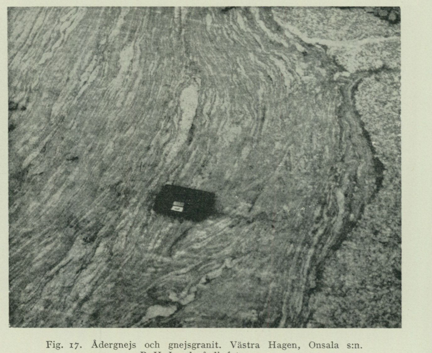
Fig. 17. Vein gneiss and gneiss granite. Västra Hagen, Onsala parish. P. H. Lundegårdh photo 1949.
is topographically marked by Kungsbackafjorden and the rift valley northwards towards Mölndal (see further the concluding chapter). On the Onsala peninsula’s most important surface-rock zone, the one that generally runs parallel to the V-shaped coastline, the extension has acted in such a way that it opened fractures along the layers in the rock portions oriented perpendicular to the extension. Due to the irregular course of the surface-rock zone and the strong cohesion along the folded layers, however, no displacements with accompanying sealing of the fractures have taken place. The space created could instead be freely utilized by upward-striving fluid. This fluid need not originally have consisted of more than water and any gases dissolved therein. For pegmatite-aplite formation, fully sufficient quantities of silicic acid and metals could namely have been obtained through partial dissolution of the permeated surface rocks.
The idea that the upward-striving fluid was originally silicate-free is supported by field conditions. Within zones such as that between Rösan and Vessingsö, gneiss rocks were once exclusively predominant. The very large and moreover irregularly distributed quantities of pegmatite that occur here must, for spatial reasons, contain within themselves the constituents of the former gneiss (see the bedrock map). Admittedly, an upward transport, in fragment form, of the now vanished gneiss may be proposed as an alternative explanation for the present distribution of the pegmatite. But such an explanation does not accord well with the observation that the gneiss remnants occurring in the pegmatite masses strike and dip
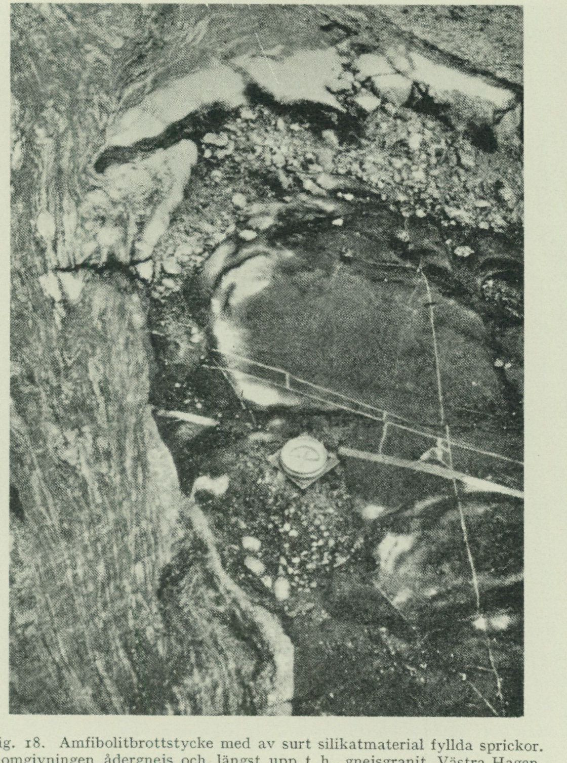
Fig. 18. Amphibolite fragment with fractures filled by acid silicate material. In the surroundings, vein gneiss and, at the top right, gneiss granite. Västra Hagen, Onsala parish. P. H. Lundegårdh photo 1949.
in the same directions as the surrounding, continuous older rock (the wall rock).
As has already been mentioned, Kungsbackafjorden represents part of a displacement zone, and the Precambrian east of the fjord has thus once lain lower than the bedrock of the Onsala peninsula. This is the explanation for why Örmanäs consists of granite transformed by vein gneiss. Certainly, granites also exist deep beneath the Onsala peninsula, which have been affected by pegmatite-aplite-forming solutions. And on the islands of Kungsbackafjorden, narrow dikes of massive red or flesh-coloured aplite run along the schistosity planes of the augen gneiss granite, dikes that are probably late-crystallized offshoots from deeper-lying granite vein gneisses. The degree of vein gneiss transformation in a section through a block of a particular rock thus appears to depend primarily on the section’s distance from the original source of the vein gneiss-forming fluid
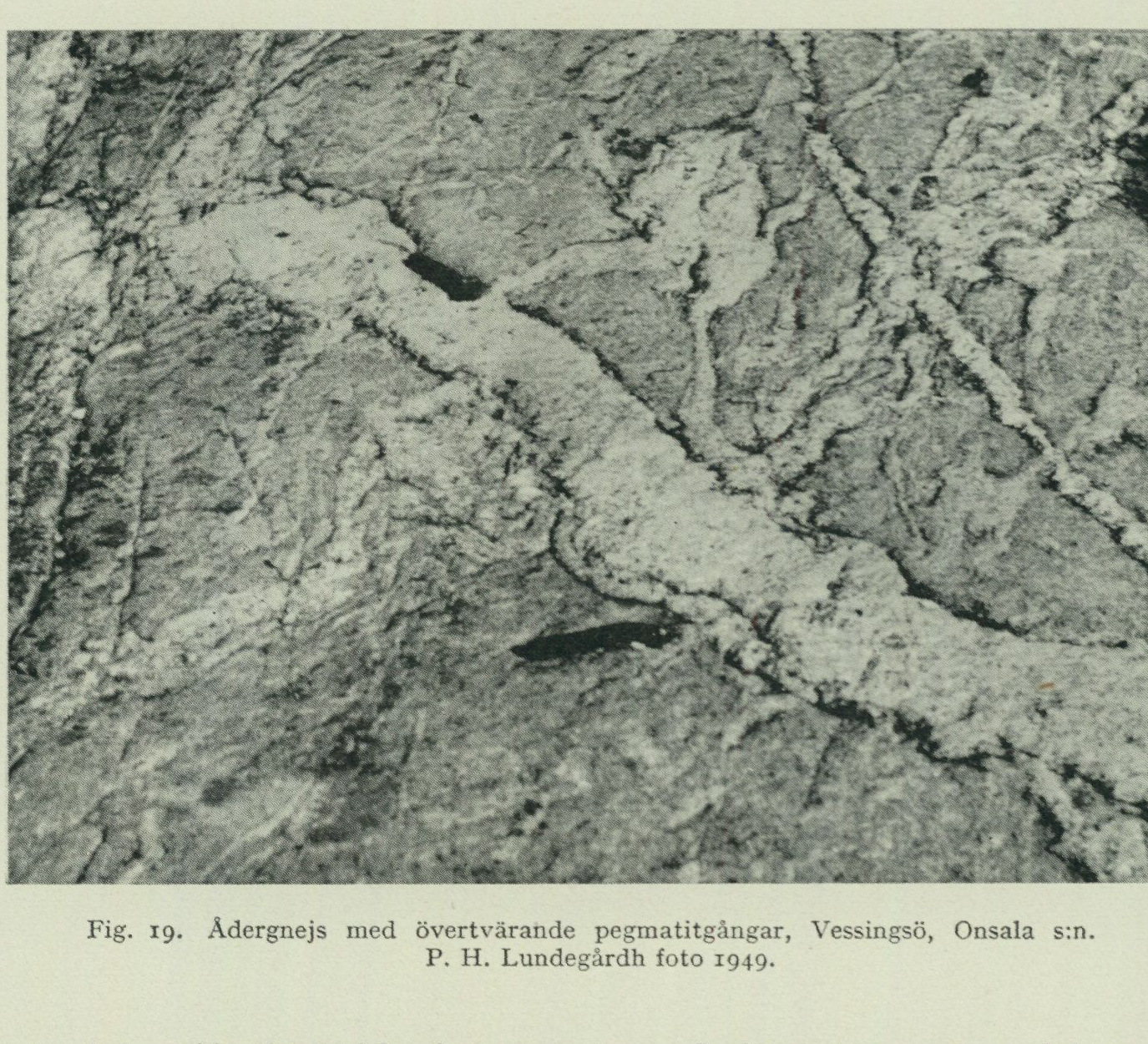
Fig. 19. Vein gneiss with transsecting pegmatite dikes, Vessingsö, Onsala parish. P. H. Lundegårdh photo 1949.
and on the temperature prevailing at the section. The higher the temperature and the shorter the distance from the fluid’s original source, the stronger the transformation.
The vein gneisses now described constitute the result of the first phase of pegmatite-aplite formation. During the vein gneiss stage, movements took place along several of the already existing bedding and schistosity planes, as shown in fig. 15, 16, 18, and 20. Already when the larger pegmatite bodies connected to the vein gneisses began to crystallize, however, these movements had probably diminished in extent. And they appear to have largely ceased before the final phase of pegmatite-aplite formation. This final phase is namely characterized by acid silicate solutions penetrating into the wall rocks of the vein gneiss–pegmatite zones and there giving rise to tectonically still completely undisturbed dikes. Similar dikes are also found within the vein gneisses (fig. 19), but there they have sometimes been distorted by late-triggered displacements along the schistosity planes of the vein gneisses (fig. 20).
Even in the crushed augen granite on the islands of Kungsbackafjorden, numerous undeformed dikes of pegmatite are found. On Brokö, moreover, a small massif of undisturbed pegmatite has been discovered. Although pegmatites in general have shown considerable resistance to deformation, there can thus be no doubt that the formation of Kungsbackafjorden was essentially completed during the initial stage of the vein gneiss period. However, displacements along the north–south-trending fracture planes in northern Halland’s bedrock have also taken place at much later occasions. Near Hällesås on map sheet Särö, a
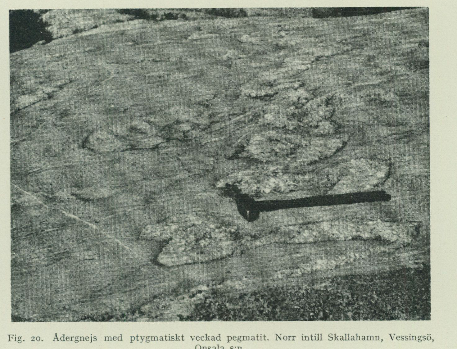
Fig. 20. Vein gneiss with ptygmatically folded pegmatite. North of Skallahamn, Vessingsö, Onsala parish. P. H. Lundegårdh photo 1949.
post-Archean, east—west diabase dyke has been cut off and displaced a distance of 300 m. In the section on granites and gneiss granites, p. 28, the occurrence of post-tectonic eyes in the gneissified Askim granite at Gottskär was pointed out. Similar to the aplitic dykes described above, these eyes are likely to have originated during the later part of the vein gneiss period.
Post-Archean diabase.
300 m SSE of Rörvik farm, inside Onsala Sandö, in the there outcropping, basic but partly microcline porphyritic gneiss granite, there is a 6 dm wide dyke of black, very fine-grained, massive diabase with sparse amygdales. The diabase dyke is curved but strikes on average towards NNE. Its length is insignificant, however, which is why the strike direction in and of itself must not be attributed greater importance. A closer examination of the diabase shows that it contains sparsely scattered plagioclase phenocrysts in an ophitic groundmass of primarily secondary hornblende (uralite) and plagioclase, but also significant amounts of magnetite (presumably titanium-bearing). As an accessory mineral, quartz appears in several places. The hornblende shows, in microscopically investigated thin sections, pleochroism in blue-green, olive-green, and green-yellow to colourless, depending on which of the three principal refractive index-
directions the eye follows. The axial angle approaches 90°. The mineral forms intergrowths of unoriented small individuals, some of which constitute unequivocal pyroxene pseudomorphs. In places, chlorite occurs together with the hornblende. The plagioclase, an andesine partially altered to oligoclase during decalcification, forms both corroded laths and more irregularly shaped (xenomorphic) individuals. Often, the mineral is completely sericitized. In its entirety, the rock gives the impression of a diabase altered under the influence of the magma’s acidic residual solutions. The potassium of the sericite, as well as the quartz, are obviously gifts from the acidic residual solutions. The partial decalcification of the plagioclases and the alteration of the pyroxenes to common green hornblende could not have taken place either without the cooperation of acidic silicate solutions. Genetically, the Rörvik diabase is associated with the east—west oriented eruptive dykes that occur further north, e.g., between Kullavik and Billdal on map sheet Särö. Much suggests that the dykes are Early Paleozoic. One only needs to recall the diabase beds of Västergötland and the volcanic activity in Great Britain, which is presumed to have given rise to the ash layers in the Ordovician of Central Sweden described by P. Thorslund.1 On the other hand, the young diabase dykes of Nordhalland (and the Göteborg area) have such an orientation that they, as S. Hjelmqvist has shown,12 can be linked to the Scanian WNW—ESE dykes. The latter are presumably Lower Permian, thus younger than, e.g., the limestones of Gotland and Öland. The fractures, which the dykes fill, would then have originated in connection with the Variscan folding in Central Europe.2
The geological development.
The West Swedish Precambrian bedrock is in its entirety younger than the bedrock of Central Sweden. While radioactive age determinations performed on pegmatite belonging to the younger intruding granites in Mälarlandskapen and Bergslagen point to the figure of 1 billion years, the age of the Bohus granite’s pegmatite lies between 825 and 865 million years, likewise according to radioactivity determinations. The younger intruding granites of Central Sweden characterize the final phase of the Sveonic cycle in the developmental history of the Swedish Precambrian bedrock, whereas the Bohus granite concludes the Gothian cycle.3 In 1947, W. Larsson laid, through his already briefly mentioned age scheme for the bedrock in northern Dalsland and southeastern Värmland (p. 12), the foundation for the subdivision of the Gothian cycle. He distinguishes the following stages in the cycle (from youngest to oldest): 16. Pegmatite and aplite (dykes). 15. (Bohus granite)4.
 1 P. Thorslund: On bentonite beds in the Cambro-Silurian of Sweden. Geol. Föreningens i Stockholm Förhandlingar. Bd 67, 1945, sid. 286—88.
3 S. Hjelmqvist: Some Post-Silurian Dykes and Problems suggested by them. S. G. U. Ser. C, n:o 430, Stockholm 1939.
3 See N. H. Magnusson in the textbook »Sveriges geologi', second ed., Stockholm 1949.
4 Rocks and formations within brackets are not represented within Larsson's investigation area but are, on the other hand, found in its vicinity.
- Quartz breccias.
- Quartz veins.
- Feldspar-bearing quartz veins.
- Pegmatite (veins, massive).
- Streak gneiss formation, gneissification, mylonite schistosity. 9. The Dal formation (sedimentary series containing basic lavas). --------- Unconformity----------- 8. (Kappebo formation: sediments and acid lavas). ---------- Major unconformity----------- 7. Åmål-Kroppefjäll granite series (diorite, granites and pegmatite veins). 6. The Åmål formation (quartzitic sediments, conglomerates, lavas and tuffs). --------- Major unconformity----------- 5. Pegmatite (veins). 4. Vein gneiss and soapstone formation. 3. (Gneiss granites). 2. Ultrabasic intrusive rocks. 1. Oldest supracrustal formation (weathering sediments, acid and basic tuffs and lavas).
Repeated foldings, fracture formation and block displacements have during the cycle’s development affected its various rocks (see Larsson’s original scheme). In the continued bedrock investigations in western Sweden, carried out by W. Larsson and the author, the basic outlines for a more general application of Larsson’s age scheme have begun to emerge. Overview excursions have since enabled a classification and a linking together of the experiences gained. It would now seem as if, farthest to the south, within the area of the geological 1:50,000 map sheets Halmstad and Laholm, we would essentially be dealing among representatives of the oldest rocks of the age scheme (1—5), while the map sheets Onsala and Särö would at least to a large extent be occupied by somewhat younger rocks. The red thread, which from these map sheets can be followed northward to north-northeast (Dalsland, Vänern), is — both literally and figuratively speaking — the Askim granite. No objection can be raised against the affiliation of the Askim granite to the Åmål-Kroppefjäll granite series. Along the entire Göta älv valley this coarsely microcline-porphyritic, usually strongly compressed granite occurs, if not in every rock then at least in some part of the river’s vicinity along its entire course. One may be more hesitant in assessing the age of the other Onsala granites. The close field relationship that prevails between these on the one hand and the Askim granite on the other, however, justifies an affiliation of all granites and gneiss granites of the Onsala land area to the Åmål-Kroppefjäll series. In terms of habit alone — that is, with respect to appearance — there are also great similarities between the granites and gneiss granites of northern Halland and Dalsland. The grey granites and gneiss granites of the Onsala land area correspond in this respect to the various varieties of the Åmål granite, while the red and red-grey granites and gneiss granites, including the Askim granite, have their counterpart in the Kroppefjäll granites and the intermediate granites belonging to the Åmål-Kroppefjäll series.
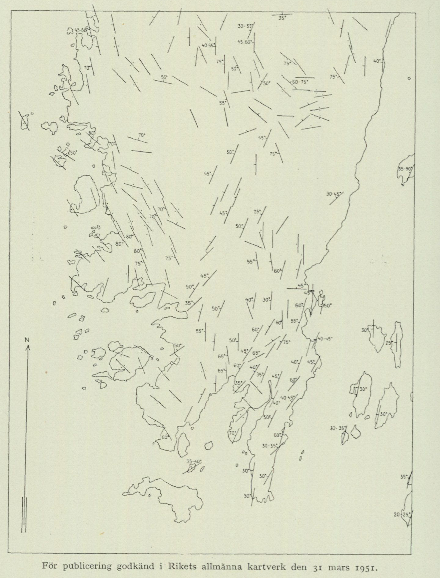
Approved for publication in the National General Map Series on 31 March 1951.
Fig. 21. Planar schistosity of the bedrock within the Onsala land area and its immediate surroundings. Scale 1:100,000.
W. Larsson already emphasizes in his age scheme that within the Åmål-Kroppefjäll series one has to reckon with local granite formation in situ from pre-existing rocks. The relationship between granite and older country rocks is thus established in Dalsland. On the Onsala peninsula the situation is the same. One can here assume that the main part of the magma, from which the granites crystallized, was formed by
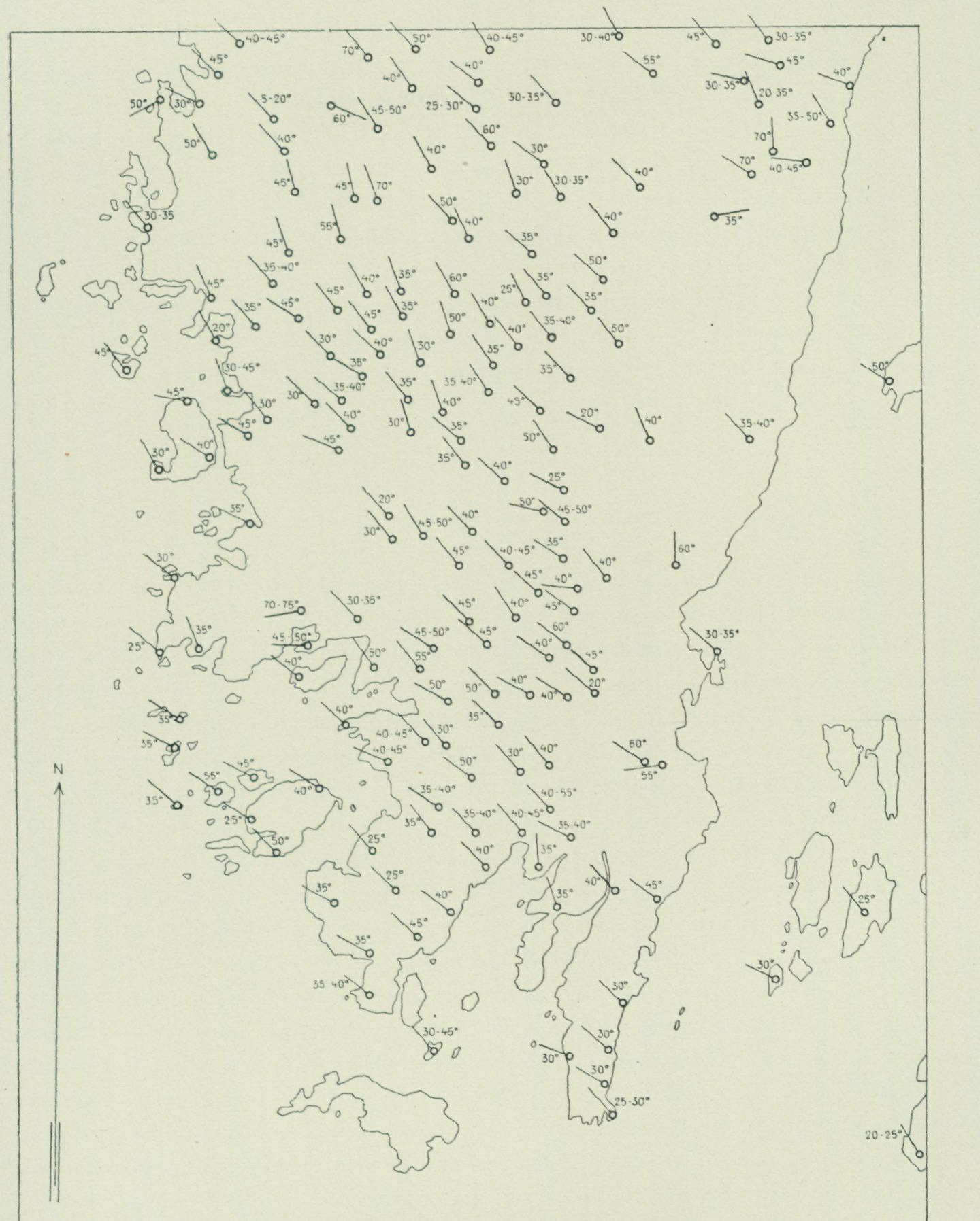
Approved for publication in the National General Map Series on 31 March 1951.
Fig. 22. Linear schistosity (lineation) of the bedrock within the Onsala land area and its immediate surroundings. Scale 1:100,000.
remelting of rocks from the supracrustal formation. The abundance of basic granite then also receives its natural explanation. It simply reflects the strong element of basic lavas and tuffs in the supracrustal formation (cf. the bedrock map). The oldest rocks in the Åmål-Kroppefjäll series are greenstones of diorite type. Such rock types also have great distribution within the Onsala sheet, but at least
partly one may here trace back from diorites and quartz diorites to basic members of the supracrustal formation. No general classification in terms of age can consequently be made regarding the dioritic greenstones of the Onsala map sheet. Regarding the gabbro rocks, the situation is in a way clearer. On the Onsala peninsula these are to a large extent ultrabasic and appear most closely to belong to group 2 in W. Larsson’s age scheme reproduced above. The gabbros would thus have formed from a basic to ultrabasic magma, which from great depth intruded into the supracrustal formation of the peninsula in connection with its folding. From what has now been stated, it follows that the supracrustal formation itself should predominantly correspond to W. Larsson’s oldest Gothic supracrustal formation (group 1 in the scheme above). Larsson distinguishes within it the following four members (from youngest to oldest):
                   IV.  Clay shale.
                      III. Quartzite.
                         II. Acidic lava and tuff rocks.
                             I. Basic lava and tuff rocks.

Schist is sparsely represented on the Onsala peninsula in the highly
metamorphic habit of the two-mica gneiss. The two-mica gneiss of the Onsala land and the Göteborg archipelago connects northwards to the low-metamorphic sedimentary schist of the Marstrand area, which can without hesitation be designated as early Gothic. Quartzite also occurs on the Onsala peninsula, although only at a few localities and there in small quantities. All the more widespread, instead, are acidic and basic lavas and tuffs. On the other hand, it is precisely with regard to these mostly strongly metamorphosed rocks (amphibolites, gneisses) that some hesitation concerning the stratigraphic-age position may arise. Even if the main part of the lavas and tuffs of the Onsala map sheet appear to belong to the oldest Gothic supracrustal formation, one cannot, even in a cursory investigation, free oneself from the suspicion that rocks of the Åmål formation do nevertheless occur in places. It is the, in certain places, strongly and abruptly varying degree of metamorphism within the supracrustal formation of the Onsala map sheet that, above all, fuels the suspicion. When one then finds, NW of Meryt, a well-preserved agglomeratic tuff with fragments of beautifully ophitic basalt lava (p. 14) but only 1 km NW thereof a streaky, contorted, highly metamorphic amphibolite gneiss, one does not appear to be able to avoid a division of the supracrustal formation. The subdivision of the supracrustal formation into two members gains increased support if one studies the bedrock map. It turns out, namely, that the zones of preserved tuff lie on the inner side of the syncline,¹ broken up by granite intrusions, distorted and marginal, which the Onsala peninsula in all probability constitutes. As is well known, the structure of synclines is characterized by the fact that the innermost layers are at the same time the youngest. Particularly significant in the present context is the field position of the acidic agglomerate tuff depicted in fig. 6 (see also p. 17). This lies out in the relatively thick gneiss granite mass of Hälteråsen, dominated by Askim granite, which in turn is enclosed by the syncline. We have here two supports for
¹ By syncline is meant an originally downward-facing fold of layered rocks in the Earth’s crust.
separating a younger member in the supracrustal formation of the Onsala map sheet: partly the position of the tuff in the centre of the syncline, partly its low degree of metamorphism. A rock which, due to its position (granite on all sides), has been so exposed to metamorphosing forces and is, moreover, acidic in composition, can scarcely be imagined to have existed from the very beginning of the Gothic cycle with its primary structure preserved. The views already presented on the geological evolution of the Onsala land require no supplementation as regards pegmatite, aplite, and vein gneiss. Here the special description should be fully exhaustive (see p. 33 ff.). On the other hand, the tectonics of the peninsula appear to warrant further discussion. It has already been pointed out (p. 19) that more than one deformation has affected the part of the Earth’s crust in which the Onsala land is included. A glance at the bedrock map and fig. 21 also clearly shows that the main part of the supracrustal formation was folded prior to the intrusion of the granites. In fact, this folding created the precondition for the formation of the deep-seated rocks. It has also been emphasized (p. 37) that Kungsbackafjorden represents part of a fracture zone and that the now exposed basement rock E of the fjord once lay lower than the present rock surface of the Onsala peninsula. This circumstance has necessitated the assumption of a downslip of the Onsala land and the bedrock lying to the north thereof relative to the bedrock east of the rift valley between Mölndal and the mouth of Kungsbackafjorden. The said slipping has, however, not taken place along a single immense slip surface but is rather the result of individually small displacements along a series of closely spaced, mutually parallel surfaces. A more general overview of the bedrock structure of Nordhalland and western Västergötland indicates that the slip movements in Kungsbackafjorden followed an older displacement zone, which at Kungsbacka turns toward ENE and continues up toward Mjörn. This displacement zone can be followed all the way to Vänern and from there onwards up into Värmland, where it has been studied in detail by N. H. Magnusson. This researcher (1949,¹ p. 84, and earlier works²) emphasizes that the Värmland gneisses west of the displacement zone show considerably stronger metamorphism than the gneisses to the east thereof. Magnusson draws from this the conclusion that the block west of the zone was pressed eastward and that an overthrust has thus been brought about. The bedrock of the Onsala land, and especially its more acidic gneiss granites, shows that a compression has also taken place here. The schistosity, which is reflected in fig. 21 and described in the chapter on granitic rocks, cannot reasonably have been caused by the stretching during the vein-gneiss episode but must have already been developed earlier. As emphasized above, the movements in the bedrock caused by the stretching have also taken place along pre-existing planes of schistosity. As regards the often quite pronounced ribbon structure (fig. 8, 13 and 22), one is inclined to think that it developed during an epoch when a pronounced pressure minimum prevailed in a certain direction. It is here implied that the ribbons follow this direction. Since the ribbon structure largely coincides with the vein
¹ The bedrock in »Sveriges geologi» [The bedrock in "Sweden's geology"]. Second ed.,
Svenska Bokförlaget, Stockholm. ² E.g. Den centralvärmländska mylonitzonen och dess fortsättning i Norge [The central Värmland mylonite zone and its continuation in Norway]. Geol. fören. förhandl. Bd. 59, 1937.
the extension direction of the vein-gneiss epoch, it might seem self-evident that the structure in question developed precisely at this time.
This is, however, with all probability not the case. The extension in northern Halland has caused both gliding and volume increases through vein-gneiss and pegmatite-aplite formation, and should therefore not to any significant extent have required reorientation of the long axes of mineral grains in already fully formed rocks. Important in this regard is the circumstance that the rocks most severely affected by the vein-gneiss transformation, as well as the new formations of the vein-gneiss epoch, generally lack lineation. Since it has been demonstrated in the Caledonian mountain chain that lineation, contrary to what one would expect, marks the directions of overthrusting and arose simultaneously with the overthrustings,*1 there are reasons to assume that the linear structure of the Onsala land has the same age as its planar schistosity. It is also intimately associated with the latter in the field.
With this we have arrived at a reasonably clear picture not only of the rock formation of the Onsala land but also of the mode of deformation of the rocks. The time scale for the geological sequence of events is, however, not fully established. We still remain in ignorance regarding the position of the vein-gneiss epoch in the age scheme of Walter Larsson cited above. It is not inconceivable that the vein gneisses, pegmatites, and aplites of northern Halland represent more than one geological epoch, though within the framework of the Gothic cycle.
1 See E. M. Anderson: On lineation and petrofabric structure and the shearing movement by which they have been produced. Quarterly Journal of the Geol. Soc. London, vol. CIV, 1948. In this summarizing work are cited, among others, fundamental investigations by the Norwegians T. Strand and A. Kvale.
The Quaternary Deposits (Quaternary System).
By R. SANDEGREN.
The unconsolidated deposits belong to the youngest geological system, the Quaternary system, and have been formed partly during the Ice Age, partly during the subsequent postglacial period, which extends right up to the present day. Accordingly, the deposits can be classified as follows:
Glacial deposits. Till deposits, consisting of unsorted mixtures of stone, gravel, sand, and clay, directly deposited by the inland ice. Glaciofluvial deposits (deposited by meltwater from the ice) have not been observed within the Onsala map sheet. Late-glacial marine deposits, consisting of gravel, sand, clay, and shell gravel, deposited in the sea beyond the ice margin.
Postglacial deposits. Postglacial marine deposits, consisting of gravel, sand, clay, salt-water gyttja, and shell gravel, deposited in the sea during postglacial time. Postglacial supramarine deposits, which were deposited on land or in watercourses with fresh water, as the area was uplifted above sea level by land uplift. These deposits consist partly of mechanical sediments (flood deposits), partly of biogenic deposits (fresh-water gyttja and peat).
Glacial deposits.
As already mentioned in the introduction, the details of the map area’s topography originate from the Ice Age, in that the advancing ice masses then excavated valleys along pre-existing zones of weakness in the bedrock, rounded and polished the rock surfaces, and to a certain extent filled irregularities and depressions in the bedrock with till material. Topographically significant are the ridges built up of till gravel, end moraines, which accumulated at the ice margin during various stages of the melting-away of the ice cover from the area. The greater part of the clay sediments, which in valleys and lowland areas constitute the substrate for arable land, were
deposited in the sea during late-glacial time. Before proceeding to the description of the deposits belonging to the glacial formations, an account shall be given of such phenomena as roches moutonnées and striations that originated during the Ice Age. The absence of glacial potholes, which has been established within the Onsala map sheet, is probably due to the fact that glaciofluvial deposits are also absent. In many places, however, the wave-washed clean rocks along the shores display those softly rounded, gentle scourings that are produced when breaking surf sets gravel and shingle in motion. Long, channel-shaped scourings have also formed in fissure clefts, where stones have been rolled back and forth by wave action. Fine examples of these have been observed, for instance, on Ö. Rön in Vallda parish.
Roches moutonnées.
Within the Onsala map sheet the shape of the rock surfaces is strongly influenced by glacial erosion, in that exceptionally beautiful roches moutonnées have developed. The roches moutonnées display, on the side from which the ice came (the stoss side), a gently arched, smoothly polished surface. On this surface one can often see the striations and grooves that precisely indicate the direction of ice movement. The opposite side of the rock (the lee side) is, in contrast to the stoss side, steep and uneven. The origin of the roches moutonnées is primarily governed by fractures and zones of weakness present in the bedrock. Where the rock is fracture-free and tough, the effect of the ice on its substrate has essentially consisted merely of abrasion, whereby the entrained material (the till) served as an abrasive. Where the rock, by contrast, is traversed by fractures, water penetrates into these, and when the water freezes, new rock fragments are constantly broken loose, removed during the advance of the ice, and incorporated into the till. The larger rock exposures are therefore often composed of several smaller roches moutonnées, each with its own pronounced stoss and lee side, fig. 23.
Striations.
The striations indicate the direction in which the inland ice moved forward at each individual point before glacial abrasion ceased there. From the Onsala map sheet there are altogether approx. 300 striation observations distributed between the directions N 10° E and S 86° E. On the map and in fig. 24, in addition to the striations measured during the geological investigation, some striation observations made by M. Thormark1 have been plotted. The striations show that the ice, in general, moved from NE towards SW. However, clear differences in the direction of ice movement appear within different parts of the map area. Along the eastern side of the Onsala peninsula and on Kalvö all measured striations show directions between N 25° E and N 45° E. Such direction also occurs on Hällesö in Kungsbackafjorden, while the majority of striations there, as well as on Brokö, Ramnö, and Vindön, come from NE and ENE. From this it appears that an ice stream was forced to follow the trough of Kungsbackafjorden. Towards the west the striations swing to increasingly ENE directions, finally, within the area between V. Hagen
1 Thormark, Marianne, Om landisens rörelser och avsmältning över Onsalalandet. G. F. F., Bd 71, 1949.
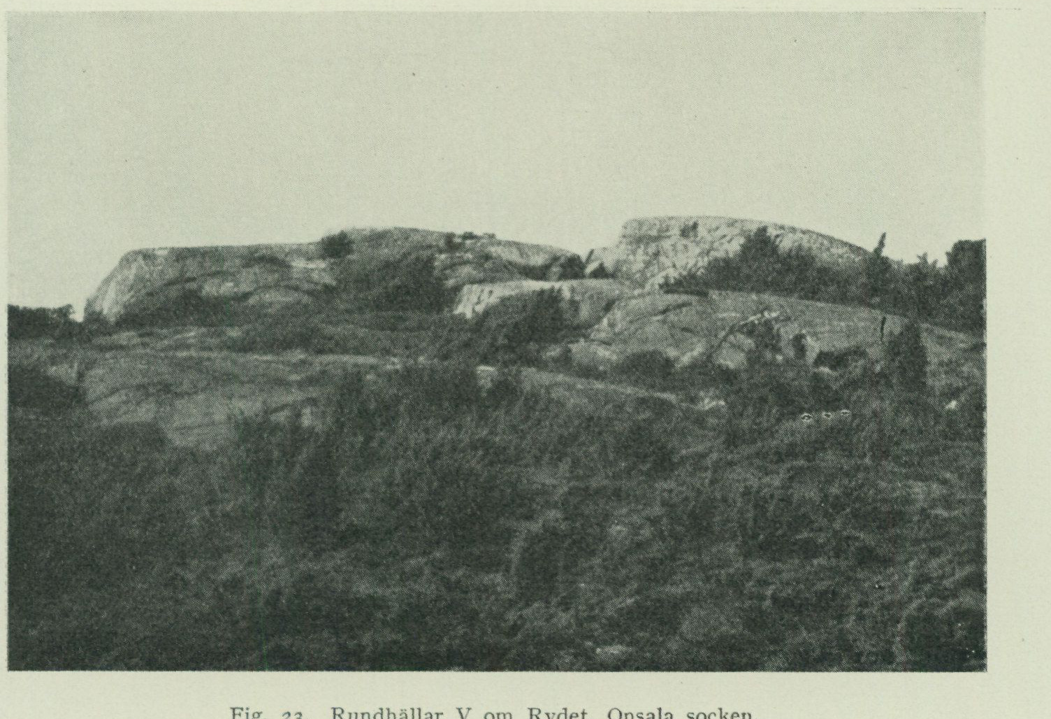
Fig. 23. Roches moutonnées W of Rydet, Onsala parish. P. H. Lundegårdh photo 1951.
and Lerkil assume an almost due east–west direction. Several striae within this area even run from S 86°–S 89° E. Finally, an observation made by P. H. Lundegårdh at Hallands Svartskär may be mentioned, where the striae run in N 10° E. On the islands E. of Rön and Snäckan, by contrast, they come from ENE. These conditions may be interpreted in several different ways. If, however, the striae are compared with the end moraines occurring within the area, fig. 24, the development during the deglaciation period appears likely to have been as follows. The striae at Hallands Svartskär probably originate from the stage when Kattegatt was still entirely filled by ice and when boulders from the Oslo field could be transported directly to Jylland. After Kattegatt became ice-free, the ice initially moved, independently of the detailed topography, from the Swedish interior in a more or less westerly direction out toward the open sea. The ice then reached as far as Rön, but not to Hallands Svartskär. As the ice sheet became thinner due to ablation, its outer parts were lifted from the sea floor. This caused detachment of ice slabs from the margin through so-called calving. The ice margin then rapidly retreated eastward within the northern part of Onsalalandet without leaving any end moraines. Finally, the mobile ice was no longer able to cross the Onsala peninsula but was forced to largely follow the Kungsbackafjorden trough, whereby the striae present here, coming from NNE, were inscribed. The recession of the ice margin within this area is handsomely recorded by the end moraines on the eastern side of Onsalalandet, which run perpendicular to the striae and clearly indicate that the recession here proceeded rhythmically, being interrupted by repeated small readvances.
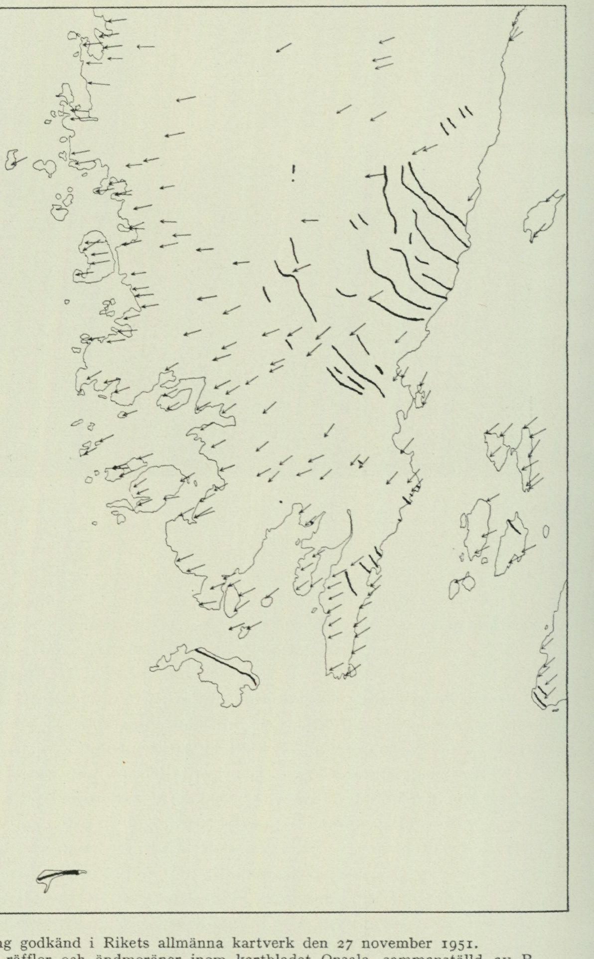
              Approved for publication at the National Land Survey of Sweden on 27 November 1951.
         Fig. 24.  Overview of striae and end moraines within the map sheet Onsala, compiled by R.
                                          Sandegren 1950.
Moraine formations.
Till gravel. Till is the term for the material that the land ice broke off, dragged along, and deposited during its advance. The greater part of the till material was transported beneath the ice mass itself and in its lowermost parts and is therefore called basal
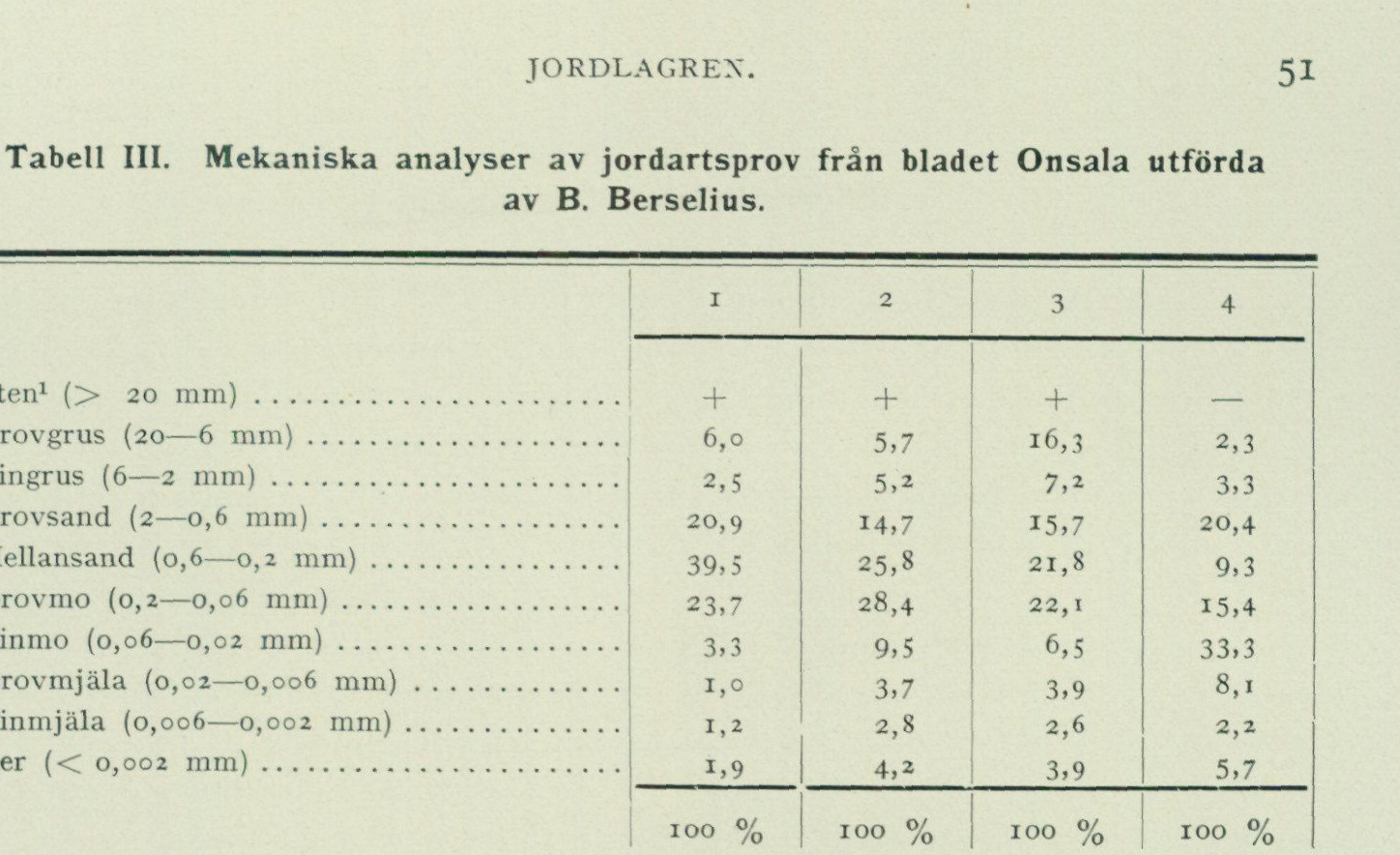
Table III. Mechanical analyses of Quaternary deposit samples from the Onsala sheet, carried out by B. Berselius
| Grain-size fraction | Sample 1 | Sample 2 | Sample 3 | Sample 4 |
|---|---|---|---|---|
| Stones¹ (> 20 mm) | + | + | + | — |
| Coarse gravel (20–6 mm) | 6.0 | 5.7 | 16.3 | 2.3 |
| Fine gravel (6–2 mm) | 2.5 | 5.2 | 7.2 | 3.3 |
| Coarse sand (2–0.6 mm) | 20.9 | 14.7 | 15.7 | 20.4 |
| Medium sand (0.6–0.2 mm) | 39.5 | 25.8 | 21.8 | 9.3 |
| Coarse fine sand (0.2–0.06 mm) | 23.7 | 28.4 | 22.1 | 15.4 |
| Fine sand (0.06–0.02 mm) | 3.3 | 9.5 | 6.5 | 33.3 |
| Coarse silt (0.02–0.006 mm) | 1.0 | 3.7 | 3.9 | 8.1 |
| Fine silt (0.006–0.002 mm) | 1.2 | 2.8 | 2.6 | 2.2 |
| Clay (< 0.002 mm) | 1.9 | 4.2 | 3.9 | 5.7 |
| Total | 100% | 100% | 100% | 100% |
- Till from 2 m depth in the end moraine S of Gatan, Onsala parish, approximately 20 m a.s.l.
- Till from 3 m depth in the end moraine at Iserås, Onsala parish, approximately 35 m a.s.l.
- Till from 3 m depth in the drumlin NE of Lunna, Vallda parish.
- Till from 0.6 m depth in a depression on Hylteråsen, Vallda parish, approximately 74 m a.s.l.
till (bottom moraine). It consists of a hard-packed mixture of worn and striated irregular and angular stones embedded in a groundmass of gravel, sand, mo, and clay that exhibits no stratification or sorting by different grain sizes. Within the Onsala sheet, the till is generally of a sandy to moa type, as shown by the analyses presented in tab. III. For further information on different till types, their characterization and occurrence, reference is made to the detailed account given by G. Lundqvist in “Bergslagens minerogena jordarter”, S. G. U. Ser. C. N:o 433. Sthlm 1940. The composition of the till with respect to the rock types contained therein is treated below in the chapter “Boulder dispersal”. As appears from the map, till occupies a relatively insignificant area on the Onsala sheet, in that within the greater part of the sheet it mainly occurs in narrow zones along the bedrock slopes or occupies small depressions in the bedrock heights. A larger area with a more continuous till cover does, however, extend on the eastern side of the Onsala peninsula, around Onsala church, where the bedrock is exposed to a very limited extent. The till-rich area extends from Rösan in the south up to the northern boundary of Onsala parish, W of the rocky islet Passberg. To the west, a smaller but comparatively till-rich area around Hästared adjoins this. The entire western part of the Onsala peninsula is, with the exception of a small area at Råö, very poor in till. On the other hand, the islands Nidingen and Malön consist entirely of till. On the older geological map sheet¹ ³
¹ The above elutriation analyses were carried out on the material remaining after stones
have been removed. According to sieve analyses carried out at the National Road Institute, the stone content in sample 1 amounts to 24 and in sample 3 to 4 per cent by weight. For comparison it may be mentioned that the stone content in the end moraine at the bus garage W of Onsala church amounts to 27 % and in wave-washed gravel at Hållsundsudde 55—68 % according to the Road Institute’s analyses, see below p. 56.
   Särö at the scale of 1 : 200,000 (S. G. U. Ser. Ab. No. 9) printed 1883, as well as on the
    geological Quaternary deposit map of Halland län at the scale 1 : 100,000 (S. G. U. Ser.
     C. No. 131), these islands are designated as glaciofluvial gravel.1
      Apart from the insignificant quantities of till material that occur in crevices and depressions in the bedrock or as narrow stripes along the sides of the bedrock heights, the till within the Onsala sheet appears in two distinct forms, namely partly as drumlins and partly as end moraines. A drumlin is a special depositional form of basal till. They consist of softly vaulted, rounded, elliptical or narrowly elongated hills and ridges with the long axis in the direction of ice movement. They are assumed to have formed through accumulation of till material around something that acted as an obstruction to forward transport. In many cases it has been established that this obstruction consists of steeply protruding solid rock. The till has been deposited partly on the stoss side, partly on the lee side, and where material was abundantly available also on top of the rock so that it was concealed, and the final result has been the drumlin's softly vaulted whale-back form, which offers the least possible resistance to the advancing gliding ice.
    End moraines are ridges or embankments extended perpendicular to the direction of ice movement. They have formed through accumulation and shoving of till material along the ice margin, when this during the deglaciation phase remained stationary for some time or advanced a short distance over an area previously freed from ice. The Onsala area exhibits numerous end moraines of all dimensions, from small ridges of a few metres' height and one or another 10-odd metres' width to imposing ridges that rise up to 15 m above the surroundings and reach a width of one or a couple of 100 m. The end moraines generally have a boulder-rich and large-block surface. In sections one can often see how layers of stratified sediments (gravel, sand, and clay) were incorporated and folded between banks of typical basal till during the construction of the end moraine.
Wave-washed Since practically the entire sheet area was covered by the sea at the time of the final till. melting away of the land ice, the till has successively, during the various phases of the shoreline displacement, been subjected to the action of waves and breakers that takes place within the shore zone. During this process, fine-grained material has been washed away from the surface layer, which therefore in many places consists solely of larger stones and boulders. Here and there, boulders of such a size lying on the bare rock that the breakers have not been able to displace them give an indication that these bedrock-exposed areas were, at least partly, originally covered by till. The till material has thus been subjected to extensive reworking and redeposition, whereby the originally angular till stones have become more or less rounded. This can be observed both within the higher-elevated shingle fields and at the present-day shore. It is really only on some of the end moraine ridges described below that
1 The same error attaches to both the aforementioned Quaternary deposit map and the map sheet Kungsbacka (S. G. U. Ser. Ab. No. 10), where a larger till elevation (drumlin) at Örmanäs, just outside the eastern border of the Onsala sheet, has been designated as glaciofluvial gravel. Unfortunately, the erroneous designation remains on Malön, Nidingen, and the Örmanäs drumlin on the new Quaternary deposit map of southern and central Sweden (S. G. U. Ser. Ba. No. 14). The southern sheet of this map was indeed printed shortly before the said error was discovered during the reconnaissance of the Onsala sheet.
crest where unwashed, true ground moraine crops out at the surface. Otherwise, the ground surface consists of washed moraine or of boulder fields, where it is not covered by a more or less thick mantle of wave-washed gravel or beach gravel. The thickness of the wave-washed gravel mantle can be measured only at such localities where sections are available. In most cases, however, it has been found to be only a few decimetres, which is probably due to the fact that the ground moraine of the area is exceedingly hard-packed and well compacted. On the map, therefore, the greater part of the moraine land has been indicated with the conventional light blue moraine colour provided with red dots, which are intended to indicate the presence of a more or less washed and redeposited surface layer. The fields consisting solely of coarse boulders have likewise been given the moraine colour together with red rings, even though the material here has been subjected to a certain redeposition. The reason for this is that, from a practical point of view, the coarse boulder field should be equated with the rich- and large-block moraine as non-cultivable land, whereas occurrences of thicker, redeposited material, beach gravel, which closely resembles the cultivable sandy land, have been given the yellow ground colour of the marine sediments together with coarse red dots interspersed in the fine red dotting that denotes sand. The end moraine ridges are indicated by rows of large dark blue dots.
Drumlins. The drumlins present in NW Halland, both within the Onsala map sheet and in the adjoining sheet Särö to the north, are as a rule developed only as softly vaulted accumulations, which rise up on the stoss side of larger bedrock heights. Such is the case, among others, with the particularly fine drumlins at Vallda church and S of Sandsjöbacka in Tölö parish on the Särö sheet. It appears as if the generally scarce supply of moraine material has been insufficient for the development of larger accumulations also on the lee side. Such accumulations do of course exist and have been described by Björsjö in S. G. U. Ser. C. No. 504 under the designation lee-side moraines or west-side moraines. Within the Onsala sheet, however, these rarely attain larger dimensions and appear on the map merely as narrow fringes of moraine situated below the steep lee sides of the bedrock heights.
Among the drumlins occurring within the Onsala sheet, mention should first be made of the large stoss-side drumlin, which from the shore of Kungsbackafjorden E of Björkgläntan rises up along the main road up to the turnoff to Meryt, where it rises to more than 30 m a.s.l. Here it is supported to the SW by bedrock, which appears in several small exposures between Meryt and the road bend S of Iglamossen. NW of and parallel to this runs another, narrower drumlin ridge, which begins at Kungsbackafjorden at the boundary between Vallda and Onsala parishes and extends towards SW up to the bedrock height situated NE of Skällared. It rises about 10 m above the clay fields situated to the NW and SE. W of Björkgläntan it carries on its crest four small end moraines trending NW—SE.
Between Högen and Lunna in Vallda parish lies a drumlin height extending from NE to SW, which is supported to the SW by bedrock. From its crest, which bears several burial mounds, one has a magnificent view over the surrounding area. A gravel pit reveals typical, hard-packed ground moraine, which reaches practically all the way up to the ground surface and displays distinct compression structures, fig. 25. A mechanical analysis of a sample from 3 m depth below the surface is given in tab. III.
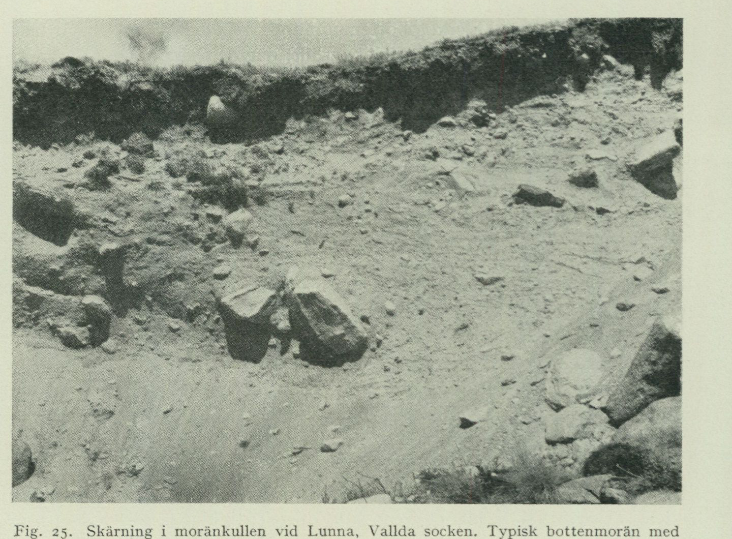
               Fig.  25.  Section in the moraine knoll at Lunna, Vallda parish. Typical ground moraine
                                                 with compression structures.
                                              G. Lundqvist photo 1951.

           Finally, mention may be made of a small drumlin knoll by the road between Köpstaden
       and Stänkelås in Onsala parish. Here no bedrock crops out at the surface.
End moraines. Within the Onsala sheet, end moraines occur on Nidingen, Malön and örmanäs, as well as in the eastern part of the peninsula, where they, particularly within the moraine-rich area around Onsala church, attain impressive forms and dimensions. When travelling along the main road Kungsbacka—Gottskär, one gains, on the stretch between Vickan and Rösan, a vivid impression of riding a roller coaster. Here the road runs nearly at right angles across the end moraine ridges and the depressions lying between them, which are partly occupied by sand and clay. The end moraines can be combined into a number of ice-marginal lines, which provide a general impression of the course of events during the melting away of the ice from the area. In fig. 24 a compilation of end moraines and striae within the Onsala sheet is provided, intended to illustrate this.¹ A brief account shall now be given of the various ice-marginal lines that have been distinguished.
Nidingen. As already mentioned, Nidingen does not consist of glaciofluvial gravel; its core is undoubtedly an end moraine with a predominantly W—E orientation; the island’s charac-
                   ¹ In M. Thormark's aforementioned work, a number of »marginal eskers» have been plotted on a map
          of the Onsala land area based on unpublished investigations by G. Lindekrantz. The map does not, however,
           include all of the area's end moraines. On the other hand, it unfortunately indicates some which, during a revision
       undertaken after the publication of the aforementioned map, were found not to exist in nature. See Sandegren,
           R.: Onsalahalvöns israndslinjer. G. F. F. Bd 72, 1950 p. 472.
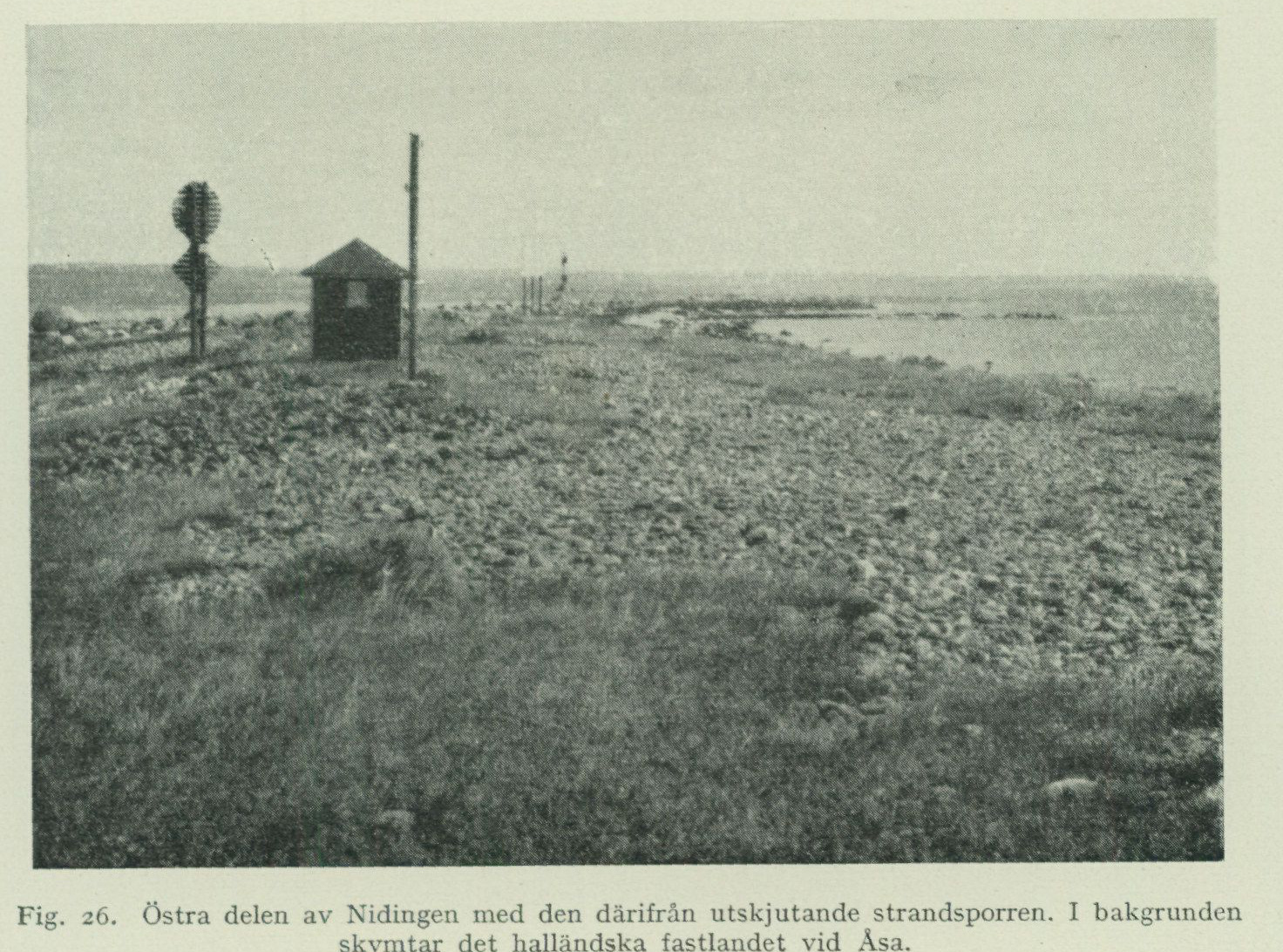
Fig. 26. The eastern part of Nidingen with the beach spur projecting from it. In the background the Halland mainland near Asa is glimpsed. P. H. Lundegårdh photo 1949.
This is evident partly from the form, partly from the large protruding boulders, which could not be moved by the breakers. The remaining material has naturally been subjected to strong reworking. The surface consists mostly of rounded shingle. Sand is absent. The point projecting toward S as well as the eastern tip of the island constitute beach spurs of coarse shingle, fig. 26. They change their shape to some extent during storms. In the middle of the island’s highest part, a stone count has been carried out, see tab. IV, p. 63.
Malön has also been incorrectly designated as glaciofluvial gravel on the older maps. The backbone of the island is, however, a pronounced, WNW—ESE-trending, large-bouldered end moraine ridge, fig. 27 and 28. A boulder occurring in the eastern part of the ridge measures 2×3×4 m above ground. The highest crest of the ridge, on which a splendid cairn is situated, reaches 14 m a.s.l. The southern part of the island, which likewise consists of till, is relatively low. Just N of the lighthouse lies a gently vaulted hill of shingle, which may possibly constitute a remnant of yet another end moraine. In that case, a large boulder of red rapakivi granite (Hållsundsudde type), which lies NW of the lighthouse, ought to have been incorporated in it. The western point of the island forms a single large field of coarse shingle, fig. 29.
On the point of Örmanäs, projecting westward near the eastern map boundary, there are two parallel, NW—SE-trending end moraine ridges, whose large-bouldered crest portions protrude from the masses of coarse shingle that otherwise cover the ground. The largest boulder on the northern moraine ridge lies right at the eastern map boundary and measures 5×5×3 m above ground.
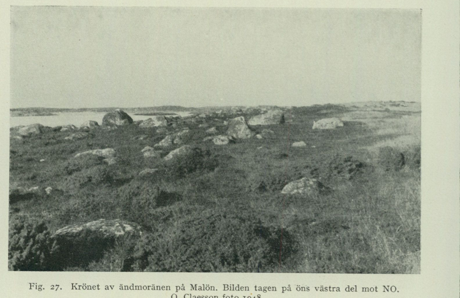
Fig. 27. The crest of the end moraine on Malön. The photograph taken on the western part of the island toward NE. O. Claesson photo 1948.
On the Onsala peninsula, one finds the continuation of this belt around Krokudden. Here, four short but distinct ridges can be distinguished. The southernmost of them is the longest. It reaches considerable dimensions and bears on its crest a stone fence of coarse shingle. This forms the highest part of Hållsundsudde, approximately 30 m a.s.l., and rises above the surrounding bedrock outcrops. According to a gravel investigation carried out by R. Gandahl for the National Road Institute, the wave-washed gravel at the crest of the hill reaches a thickness of 4 m, while on the northern slope it is approximately 1 m thick and rests on till. The stone content of the wave-washed gravel amounts at the former locality to 55, at the latter to 68 %. The quantity of gravel present here is estimated at 30,000 cu m, suitable for crushing into road gravel.
The following ridges are situated at a lower level. The second of them runs between two rock-outcrop areas, the third northwestward from the rock outcrop that forms Krokudden itself. The fourth, which is quite short, runs out into a small point at the shore N of Krokudden.
Further toward NW, the continuation of the belt can be traced only in a small till point projecting southeastward from the eastern shore of Röda holme and in a small hill with a gravel pit, which abuts the western side of the narrow, north—south-trending valley at Knastås. The continuation of this marginal belt toward SE should presumably be sought in the long-known end moraine series that occur at Värö Backa and between Hunnestad and Grimeton, E of Varberg. Through this, an approximate conception is obtained of the probable chronological position of the ice-marginal formations occurring on the Onsala peninsula in relation to the beautiful end moraine belts on the central Halland coastal plain.
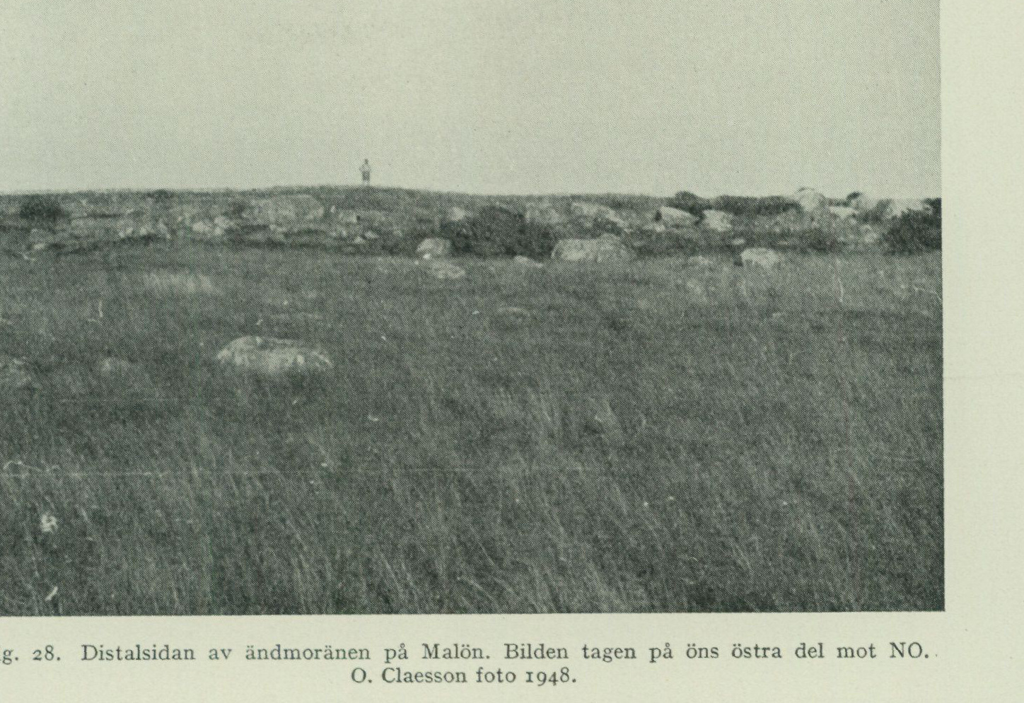
Fig. 28. The distal side of the end moraine on Malön. The photograph taken on the eastern part of the island toward NE. O. Claesson photo 1948.
On the northern part of Vindö in Kungsbackafjorden there is an end moraine that runs out into a point toward NW. From the eastern shore of the Onsala peninsula at Dunkelihög and Draget, four small short till points run out toward SE. A continuation toward NW of the southernmost of these can possibly be traced at Dunkelihög. Here, the valley fill consisting of beach gravel and sand forms a sill, which is composed of somewhat coarser material than that occupying the valley in general and from which the ground slopes both toward N and S. All material is, however, so strongly reworked that on the map only beach gravel could be marked. As a continuation toward NW of the moraine ridges at Draget, a pronounced till hill, which protrudes from the clay field just SE of Prästäng, should be regarded. Further toward NW, no traces of this belt have been observed.
Just E of Mårtagården, two approximately parallel end moraine ridges run in an ESE—WNW direction. They have gently vaulted forms and contain so much fine material that they are to some extent cultivated in connection with adjacent clay fields. Uncultivated crest portions show, however, that the surface of the ridges was originally both large-bouldered and rich in boulders, before the systematic gathering of boulders into stone fences in connection with cultivation imparted to the landscape the strong cultural character it possesses today. In the continuation of these ridges toward NW, there is at Liden a small, beautiful, well-defined end moraine ridge, and at Köpstaden another such ridge, which has, however, been partly levelled by cultivation.
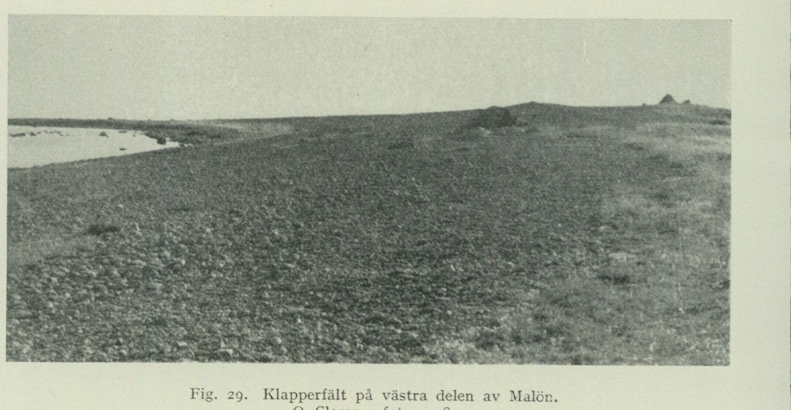
Fig. 29. Shingle field on the western part of Malön. O. Claesson photo 1948.
Rösan mor- The Rösan moraine begins up on the bedrock NW of Gottskär and extends in a north- aine westerly direction past the road junction with the elevation figure 20 and the Rösan farm up to the high hill at Rydet. The new main road Gottskär—Mariedal runs, on the stretch from the said road junction to Rydet, on the distal slope of the moraine. An older road, not shown on the map, runs along the crest of the ridge. S of Gatan there is a gravel pit, which shows that hard-packed, typical basal moraine at the crest extends practically all the way up to the ground surface. There it is covered only by a quite thin mantle of wave-washed gravel, through which the larger boulders protrude, fig. 30. In the gravel pit one can see how the ridge is built up of several slabs of till gravel with distinct pressure structures. These slabs have been thrust up over one another toward the SW and are inter- bedded by thin lenses of stratified gravel, in which beautiful flow-cast phenomena appear. Mechanical analysis of the till from 2 m depth below the surface is found in tab. III, p. 51. On the other side of the hill at Rydet the moraine continues NW of Vrån as a small, narrow and low but distinct ridge, which extends toward the NW up to the Marie- dal schoolhouse, where it is damaged by gravel extraction and grading. Along the road to Hästared it is broader, but very low and flat, although fully discernible in this cultivated terrain. W immediately next to the road junction at Hästared the moraine is destroyed by a large gravel pit at the place where the road out to Västra Hagen passes between a couple of bedrock knolls. From here the moraine, although on this stretch it is very low and flat, can be followed further toward the NW through the cultivated land up to the hill at Lindfjäll.
Lyngås mor- About 300 m NE of Rösan the main road Gottskär—Kungsbacka crosses over a aine prominent moraine hillock with a NW—SE-trending long axis. Not far beyond this hillock, to the NW, follows a narrower moraine ridge, which just N of St. Lyngås abuts against the bedrock.
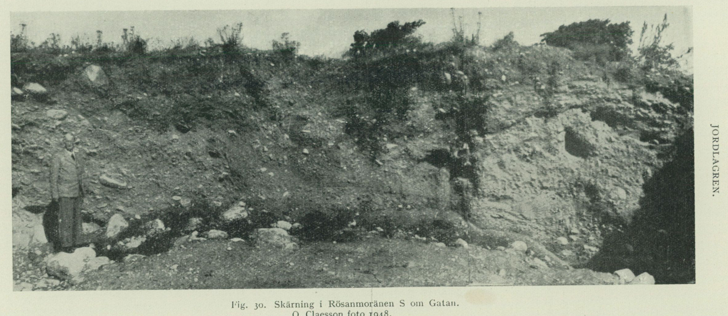
                                          Fig. 30. Section in the Rösan moraine S of Gatan.
                                                  O. Claesson photo 1948.
The Iserås moraine. The Iserås moraine begins at Enen and extends toward WNW. It is crossed by the main road 200 m SW of the elevation figure 29. W of the main road it becomes broader, and its central part is occupied by a large, shallow gravel pit. In the NW it creeps close to the bedrock E of Iserås. On the western side of the bedrock, at Iserås farm, the moraine continues toward W. Although badly damaged by several gravel pits, it here possesses a beautiful ridge form. The gravel pits show typical, hard-packed basal moraine right up to the ground surface. Mechanical analysis of a sample taken 3 m below the surface is found in tab. III, p. 51. W of this, the moraine bends toward NW, is crossed by the main road, and abuts against the bedrock at Hästliden. The continuation of the zone is found in the considerable moraine masses accumulated between the hills NW of the road bend at Hästared, and from which a high, pronounced ridge projects toward NNW into the clay land S of Håkulla. From the striae, running in almost straight east–west direction E of Håkulla, it also appears that the ice margin here swung round, so that it came to occupy an approximately north–south direction. The continuation of the Iserås moraine should therefore be sought in a low, ridge-shaped moraine accumulation with a gravel pit at the northern end of the large hill SE of N. Hagen, and in an approximately 100 m long, large-blocky and well-marked moraine ridge with north–south direction, on the crest of the height W of Bolgen. The moraine ridge is thus higher than the bedrock surface situated immediately E thereof, and is separated from it by a small depression.
The Karsegård moraine. The Karsegård moraine begins N of Enen a short distance from the shore. It is remarkably imposing and initially runs parallel to the Iserås moraine. Karsegården lies on its proximal slope. At Gottskärsvägen it has been damaged by gravel extraction and leveling. Karsegården’s grocery store is, however, probably situated on the original crest. The distal slope is here very fine, especially immediately E of the main road. Between Gottskärsvägen and Mariedalsvägen the ridge has been lowered and flattened by extensive gravel extraction and development. Here was presumably located its broadest and highest section. N of Mariedalsvägen the moraine runs in an arc toward NW and NNW, extends as a promontory into the clay land V of Staregården, and terminates abruptly there. In the continuation of the zone lie two ridges that run in a northwesterly direction across the moraine hill at Mossen.
The Onsala church moraine. The Onsala church moraine begins with a small, large-blocky promontory projecting into Kungsbackafjorden and initially runs essentially parallel to the Karsegård moraine. It rises rapidly to considerable height. The section S of the parsonage is without doubt the most imposing of all on the entire Onsalahalvön, although it is difficult to survey due to growing forest. Its surface still bears numerous large boulders, although many such have been cleared away, fig. 31. Around the church the crest has been leveled, but immediately V of the main road the moraine rises steeply to the mighty hill on which the old windmill stands. It displays an imposing distal escarpment at the omnibus depot. In its continuation the ridge runs in an arc toward NNW and NW up to the road S of Staregården. Here the ridge form is lost for a short stretch, but the moraine strip along the road northward past Staregården appears to indicate that the church moraine has its continuation in the high and sharp moraine ridge that runs from Staregården in nearly northerly direction past Norrelund and Apelröd
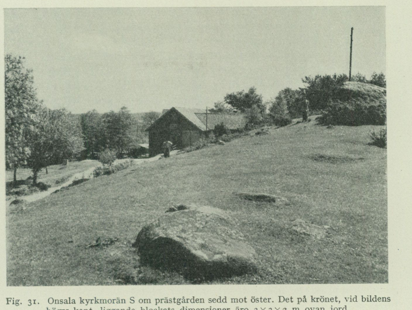
and which is followed by a small cart road. N of Apelröd the ridge becomes lower, but continues between two peat-filled depressions, until it loses itself in the moraine accumulation on the southwest slope of the height extending N of here.
Between the Onsala church moraine and the Finnagård moraine situated NE thereof, there are three shorter ridges with unequivocal end-moraine form. One of them begins, like the church moraine, with a small promontory at the shore of Kungsbackafjorden and extends toward WNW to a point N of the parsonage. This ridge is probably one of the least affected by cultivation in this area, and its surface in the forest NE of the parsonage is richly strewn with large boulders. A second runs E of the main road, N of the church, where its most large-blocky parts appear as uncultivated islands in the field. The third is an almost north–south-trending, sharply marked ridge with a road and dense villa development on the western side of the main road. It drops very steeply down toward the peatland with the elevation figure 24 directly E of Staregården. Together they form a zone parallel to the other end moraines present here.
The Finnagård moraine. The Finnagård moraine begins at the shore of Kungsbackafjorden and extends toward NW. It is remarkably imposing. Finnagården lies on its crest, and from here one has a particularly fine view. The distal escarpment SE of the farm is very large-blocky. At the far NW the ridge is high and narrow and extends as a promontory into the present peatland.
Fig. 31. The Onsala church moraine S of the parsonage seen toward the east. The dimensions of the boulder lying on the crest, at the right edge of the image, are 3×3×2 m above ground. G. Lundqvist photo 1951.
The Vickan moraines.
At Vickan two imposing end-moraine ridges extend in a northwesterly direction, parallel to and at only about 250 m distance from each other. The southern one begins on the promontory NE of Finnagården, is crossed by the main road at Vickan, and continues from there first toward the NW before curving toward N on the western side of the peatland marked with the elevation 29. The northern one begins at the shore S of Meryt, is crossed by the main road NE of Vickan, and then continues on the eastern side of the aforementioned peatland. Both fade out into the moraine terrain on the southern slope of the upland area N of Skällared.
End moraines N of Björkgläntan.
Across the drumlin ridge N of Björkgläntan mentioned on p. 53, four small end moraines run in a northwest—southeast direction. They project into small points in the clay fields situated on either side. The southernmost end moraine is 4 m high; the others are somewhat lower.
Boulder dispersal.
The boulders incorporated in the morainic gravel and its reworked products (wash gravel, beach gravel) consist, for the most part, of rock types belonging to the district’s own bedrock. Gneisses, gneiss granites, and greenstones thus constitute the main mass of the stones in these soil types; see Table IV. In addition, however, a considerable number of boulders of rock types from sometimes quite distant areas are encountered. These exotics can be assigned to three different categories with regard to the manner in which they arrived at their present location. The first group comprises so-called indicator rocks, which are embedded in the till and derive from more or less distant areas that the land ice passed over before reaching the map-sheet area. They can thus serve as a guide in assessing the ice movement directions, hence the name. The striations indicate, as mentioned above, that the ice generally came from the N and NE. Among the far-travelled boulders transported from these directions, mention may be made of red, Jotnian sandstone from Dalarna, individual stones of which have been observed as far out as on Malön and Nidingen. Cambrian sandstone and red Orthoceras limestone of types that crop out in Västergötland and Närke have been observed, among other places, on Öckerö. There, a boulder of a black-grey limestone with oolitic phosphorite nodules has also been found; according to F. Brotzen, these contain fossil remains such as ostracods or bryozoan fragments. The rock probably belongs to the Lower Ordovician, but its provenance is uncertain.
Ice-rafted boulders.
The second group comprises so-called ice-rafted boulders, which arrived at their present location by means of floating icebergs, calved from marine-terminating parts of the inland ice and carried onward by wind and currents until they melted, whereupon the till material frozen into the ice was deposited on the then-existing sea floor. The ice-rafted boulders are therefore found either lying loose on the ground surface or embedded in wash gravel, beach gravel, or glaciomarine clay. When walking on the washed shingle deposits within the Onsala map sheet—both at the present shoreline and at higher levels—one is struck by the great abundance of sedimentary rocks foreign to the district’s own bedrock, which occur
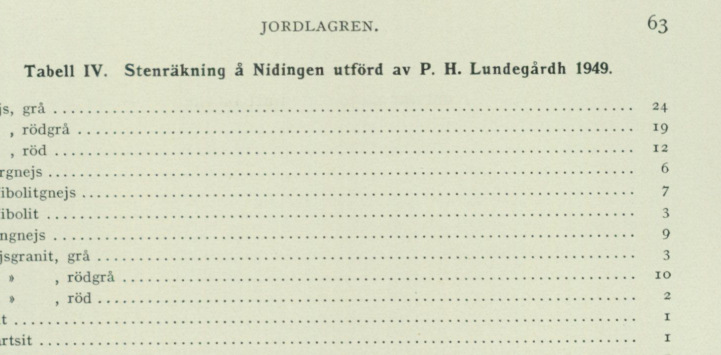
Table IV. Stone count at Nidingen, carried out by P. H. Lundegårdh in 1949
| Rock type | Count |
|---|---|
| Gray gneiss | 24 |
| Red-gray gneiss | 19 |
| Red gneiss | 12 |
| Vein gneiss | 6 |
| Amphibolite gneiss | 7 |
| Amphibolite | 3 |
| Augen gneiss | 9 |
| Gray gneiss granite | 3 |
| Red-gray gneiss granite | 10 |
| Red gneiss granite | 2 |
| Aplite | 1 |
| Quartzite | 1 |
| Quartzite sandstone | 1 |
| Chalk limestone | 1 |
| Flint | 1 |
| Total | 100 |
In addition, a block of red Dala sandstone was observed. Flint and chalk limestone do not occur in the moraine of these parts but have been transported here as drift-ice blocks.
there. Foremost among these is flint belonging to the Cretaceous formation. One need not take many steps on a shingle beach to find flint stones of varying size rounded by the surf, but white or light-gray limestones belonging to the same formation are also very common. These rock types have, however, never been encountered in the moraine on the Onsala peninsula. Since it is known that the rocks in question crop out in Skåne and Denmark and in all probability also on the floor of the Kattegatt, it is evident that these drift-ice blocks originate from the said areas. They must have arrived in the Onsala area during a phase of late-glacial time, when large parts of Sweden’s present west coast were ice-free, but the outermost tongue of the youngest Baltic ice still reached out into the southern Kattegatt. The assumption that the ice which delivered the Cretaceous rocks was of Baltic origin is supported by the find of a block of red Baltic Sea quartz porphyry among the beach shingle on Malön. Within the Onsala map sheet, drift-ice blocks of exotic sedimentary rocks have been collected from a number of localities such as Nidingen, Malön, örmanäs, Öckerö, Råö, Orrviken, Knaperyd, Knastås and Röda holme. The material has been examined by Dr F. Brotzen, who has reported the following on the matter.
Gray sandstones with a typical rusty weathering surface, found at Råö, Knastås Jurassic rocks. and Röda holme, can with the greatest certainty be referred to the Rhaetic-Liassic. This assumption is confirmed by the coal fragments that here and there occur in the sandstone. Such sandstones are quite common in the Scanian Rhaetic-Liassic deposits and would indicate transport from the south. But the most recent investigations in Denmark show that Rhaetic-Liassic occurs in northern Jylland beneath not very thick chalk (lecture by Gregersen and Sorgenfrei, Nordic geological meeting in Copenhagen 1951). This indicates that pre-Cretaceous layers can reach the Earth’s surface
     beneath the Quaternary, both N and E of northern Jylland, i.e. in southern Skagerack
        or northern Kattegatt. The possibility remains that the blocks were transported from
      the north, respectively northwest, to the find site.
    A sandstone slab, about 25 cm long, 16 cm wide and about 1.5 cm thick, found
    on Röda holme, shows on one side a typical packing of musselstone nuclei,
    among which one may distinguish _Protocardium_. The others are so incompletely
     preserved that a determination requires more extensive preparation. The rock
     closely resembles certain fossiliferous Liassic rocks in Skåne, but the fossil
      content cannot be compared with these (statement by Prof. G. Troedsson).
     _Protocardium_ is known only from Trias–Cretaceous and no longer occurs
       in the Tertiary. The occurring _Protocardium_ species do not belong to any
   Cretaceous species but show the same features that characterize those from
   the Jurassic. It is therefore reasonable to classify the block as Jurassic,
      possibly belonging to Upper Jurassic
      formations. These have long been known as blocks
     in northern Jylland and have now been encountered _in situ_ in fissures during
     borings there.
Chalk rock All chalk rocks belong to the Danian, and one may distinguish three types: lime- types. stones of calcarenite type, belonging to the Upper Danian, limestones with abundant bryozoans (bryozoan limestone), which mostly belong to the Middle or Lower Danian, grey flint or siliceous limestone, mainly from the upper part of the Danian. The Danian rocks most probably belong to the Danian province of Själland and Skåne. Large parts of the Kattegatt bedrock must also be assigned to this province, and nothing contradicts the occurrence of these rocks in outcrop also off the coast of Halland. It is surprising that these Danian rocks are relatively common on the Onsala map sheet, while blocks from the southern Halland chalk deposits (the Båstad district chalk) are absent. This would suggest that transport took place solely from Denmark or from the Kattegatt floor. The latter seems more likely, since black Senonian flint blocks from northern Jylland are also absent.
Tertiary A clay ironstone nodule, resembling septaria from the Oligocene clays of Denmark, rock? has been found at Råö. It is free of fossils and therefore cannot be determined with certainty. Another possibility is that the block may be referred to certain clays from the Lias with clay ironstone geodes, but this is less likely.
     The third group of exotic blocks comprises those brought from other areas by
     human activity. Foremost among these are blocks used
    as ballast, discharged from vessels at harbours and loading places, or deposited
    near the shore upon vessel strandings and subsequently taken up
    by the surf. Ballast blocks can easily, unless their true character
      is revealed, give rise to misleading geological conclusions.1

                 1 See on this matter e.g. Wallerius, I. D., Ett par bohuslänska blocknotiser. G.F.F. Bd 51, 1929, pp.
     100–104, and Wiman, C., Om förekomster av fossilförande block. G. F. F. Bd 52, 1930, pp.
     134–135.
Changes of sea level.
As a result of the considerable pressure exerted by the massive continental ice sheet on the earth’s crust, the latter was depressed, so that large parts of our country came to lie below sea level. When the ice began to melt away and the pressure gradually diminished, the land within the glaciated area began to rise again. Since the depression was greatest in the central parts of Scandinavia, where the ice cover attained its greatest thickness, the postglacial land uplift has reached greater amounts there than in the peripheral parts of the glaciated area. The highest marine limit (MG) therefore shows, in southern Sweden, progressively higher values towards the north and inland, thus demonstrating the non-uniformity of land uplift. This land uplift continues to the present day because the earth’s crust has not yet regained its original equilibrium position. In northern Halland, land uplift is now insignificant (about 1 cm per 100 years), but in Ångermanland it amounts to nearly 1 m per century.1 At the same time as land uplift proceeded, however, the volume of water in the world ocean increased through the melting of the continental ice sheets, causing sea level to rise. In those regions where land uplift proceeded faster than sea-level rise, regression prevailed (i.e. a downward displacement of the shoreline). In those regions, on the other hand, where no land uplift occurred, or where land uplift proceeded more slowly than sea-level rise, transgression prevailed (i.e. an upward displacement of the shoreline). Through earlier observations along the Swedish west coast, including in northern Halland,2 and in the Göteborg area,3 it is known that after the deglaciation of the latter regions a rapid regression took place in late-glacial time. Thereafter, already during the Ancylus stage, a marine transgression began, reaching its maximum during the Stone Age at the so-called Tapes-Litorina limit or postglacial limit (PG). Then followed the regression through which the shoreline was displaced down to its present position. Important details in this sequence of events have been obtained through observations within the Onsala map sheet, partly already in the 1890s (Lunna mosse) and on several later occasions, and partly during the reconnaissance for the map sheet now presented. Among other things, it has been established that the postglacial regression in the Onsala area was interrupted by a minor transgression during the passage-grave period, GG in Table VIII, cf. also Fig. 46. In the following, an account of the investigations carried out within the map sheet will be given. The reader particularly interested in sea-level change problems is further referred to the publications mentioned below.4
1 Bergsten, Folke: Den nutida landhöjningen vid Sveriges kuster. — Ymer, Årg. 59, Sthlm
1939. 2 Halden, B. E.: Tvänne intramarina torvbildningar i norra Halland. S. G. U. Ser. C. No. 310, 1922. 3 Beskrivning till kartbladet Göteborg, S. G. U. Ser. Aa. No. 173, 1931, pp. 92–97. 4 Sandegren, R.: Om den postglaciala havstransgressionen vid Sydsveriges kuster. G. F. F. Bd 56, 1934. — De senkvartära nivåförändringarnas problem. Ibid. Bd 68, 1946. — Svenska nivåförändringsproblem. Medd. fr. Dansk. Geol. Foren. Bd 11 (1946). København. 1947.
Late-glacial marine deposits.
      Those parts of our country, including the Onsala peninsula, that lay below
      sea level at the end of the ice age, became covered by the sea after the
      melting of the inland ice. Here, deposition of clay, sand, or shore gravel took
      place depending on the level and location of each particular place. Within the
      shore zone, i. e. the band worked by wave action that lies closest above and
      below the actual water surface, fine material was washed out of the till
      gravel left by the ice and deposited as sand and clay in deeper and calmer
      water. As regression progressed, wave action came to operate at progressively
      lower levels. Protruding bedrock areas were to a large extent completely
      washed clean, partly of such clay as had been deposited on the till when the
      latter still lay under water, and partly of the till gravel itself. Only those
      large boulders that the waves were unable to move remained lying on the bare
      rock. Surface layers of till remaining in more sheltered locations were
      reworked to a greater or lesser extent into wave-washed gravel and shore
      gravel. During subsequently occurring transgressions and regressions, the
      process was repeated. In this way, a very large proportion of the
      unconsolidated deposits has been subjected to extensive reworking processes,
      of which the stratigraphy in accessible sections bears witness.
Marine The highest marine limit (MG) could not be exactly determined within limit. the Onsala map sheet. Guided by the fact that this limit lies 77 m above the present sea level just N of the western end of Lake Lygnern (9 km ESE of Kungsbacka) and 95 m at Göteborg, it may nevertheless be calculated that the only part of the Onsala sheet that was never covered by the sea in late Quaternary time is a small area on Hylteråsen in Vallda parish, the highest part of which reaches 84.72 m a. s. l. Reconnaissance of Hylteråsen and its surroundings yielded the result that the bedrock, both on the summit and at lower levels, lacks a till cover, with the exception of a small depression SW adjacent to the now-removed aviation beacon. Here, a deposit approximately 1 m thick is found, which is likely till. The ground surface lies at approximately 74 m a. s. l. Mechanical analysis of a sample taken 0.6 m below the surface at that locality is reported in Table III. The calculated MG on Hylteråsen would lie at approximately 79 m a. s. l. Just S of Sandsjön on the Särö sheet, MG has been observed at approximately 83 m a. s. l., a value that agrees well with calculations based on the determinations at Lygnern and at Göteborg. In Fig. 32, the calculated MG on Hylteråsen has been plotted.
Glaciomarine The finest suspended material, carried by meltwater from the land ice out clay. into the sea located beyond the ice margin, was deposited there as clay on the sea floor. The glaciomarine clay rests on till — or, where such is absent, directly on bedrock. In the deeper layers it is usually blue or grey-blue and often shows black, irregular spots and streaks of iron sulphide. The clay possesses, mainly due to embedded calcareous shells, often a more or less prominent calcium carbonate content. The varves, caused by the annual periodicity in the melting of the ice, which characterize the late-glacial clays over large parts of our country, are found in the coastal tracts of western Sweden only in the bottom layers of the glaciomarine clay. This circumstance has
its cause in the salinity of the seawater. In salt water, a coagulation of the clay particles takes place, with the result that the deposited sediment lacks varvation. It was therefore only in the immediate vicinity of the ice margin, where the salinity was strongly diluted as a consequence of the outflowing meltwater masses, that annual varves could form. The clay that was deposited farther from the ice margin, by contrast, became homogeneous. Varvation has nevertheless been observed at some localities, e.g. during a borehole E of Lunnaled in Vallda parish, where the clay at a depth of 8 m below the ground surface displays weakly pronounced varvation.
The uppermost layers of the clay form a solid dry crust of varying thickness. As a result of weathering and aeration, the dry crust acquires a lighter colour in various brown and greyish-yellow shades. It also frequently shows irregular rust mottles. The calcareous shells have been dissolved, so that the uppermost layer is poor in lime. The clay of the dry crust forms a very stiff and tenacious soil type, which during severe drought can become cement-like hard, while in a waterlogged state it becomes sticky and adhesive. As a result, it constitutes a rather difficult soil to work.
Below the dry crust, the clay has a high water content and a plastic consistency. Sometimes it is so loose that it may rather be described as clay-laden water than water-bearing clay. For heavier construction works, this entails the disadvantage that slides and slumps readily occur, especially in places where thick clay layers in sloping terrain occupy a position of unstable equilibrium.
As can be seen from the map, glacial marine clay has considerable distribution within the Onsala map sheet, where it occupies the greater part of the valleys and plains situated between the bedrock heights. Even in places where the surface layers consist of sand, postglacial clay, or peat, glacial marine clay is generally encountered at greater or lesser depth beneath these deposits. Regarding the map designations for glacial marine clay and postglacial clay respectively, it must be pointed out that the uppermost layers within some of the lowest-lying areas designated on the map as glacial marine clay have in fact been deposited in postglacial time, as is evident from the microfossil content of the clay. This clay, which constitutes a direct reworking product of glacial marine clay washed down from higher-lying areas during the older phases of the postglacial period, nevertheless possesses the character of stiff clay typical of glacial marine clay and has therefore, for practical reasons, been grouped together with it. The map designation “postglacial clay” has in turn been reserved for the youngest, strongly silt- and gyttja-bearing light clays, which possess entirely different properties and which will be described further on (pp. 74—76).
As mentioned, the glacial marine clay is rich in shells of organisms characteristic | Shell finds in of the Arctic seas (bivalves, gastropods, barnacles, etc.). On the map, special | glacial marine clay symbols have been placed where shell finds were made during the geological reconnaissance of the area. A closer investigation of the fauna, which is reported in tab. V, has been carried out on samples from the following localities.
Approx. 250 m SSW of Onsala church, E of the main road in the depression between the Karsegård moraine and the Onsala church moraine, approx. 30 m a.s.l., shell-bearing clay was reached during well-digging beneath the surface layer consisting of sand and gravel.
Approx. 600 m NE of the schoolhouse at Mariedal, NW of the main road, approx. 25 m a.s.l., shell-bearing clay was reached during well-digging beneath the surface layer consisting of shore gravel.
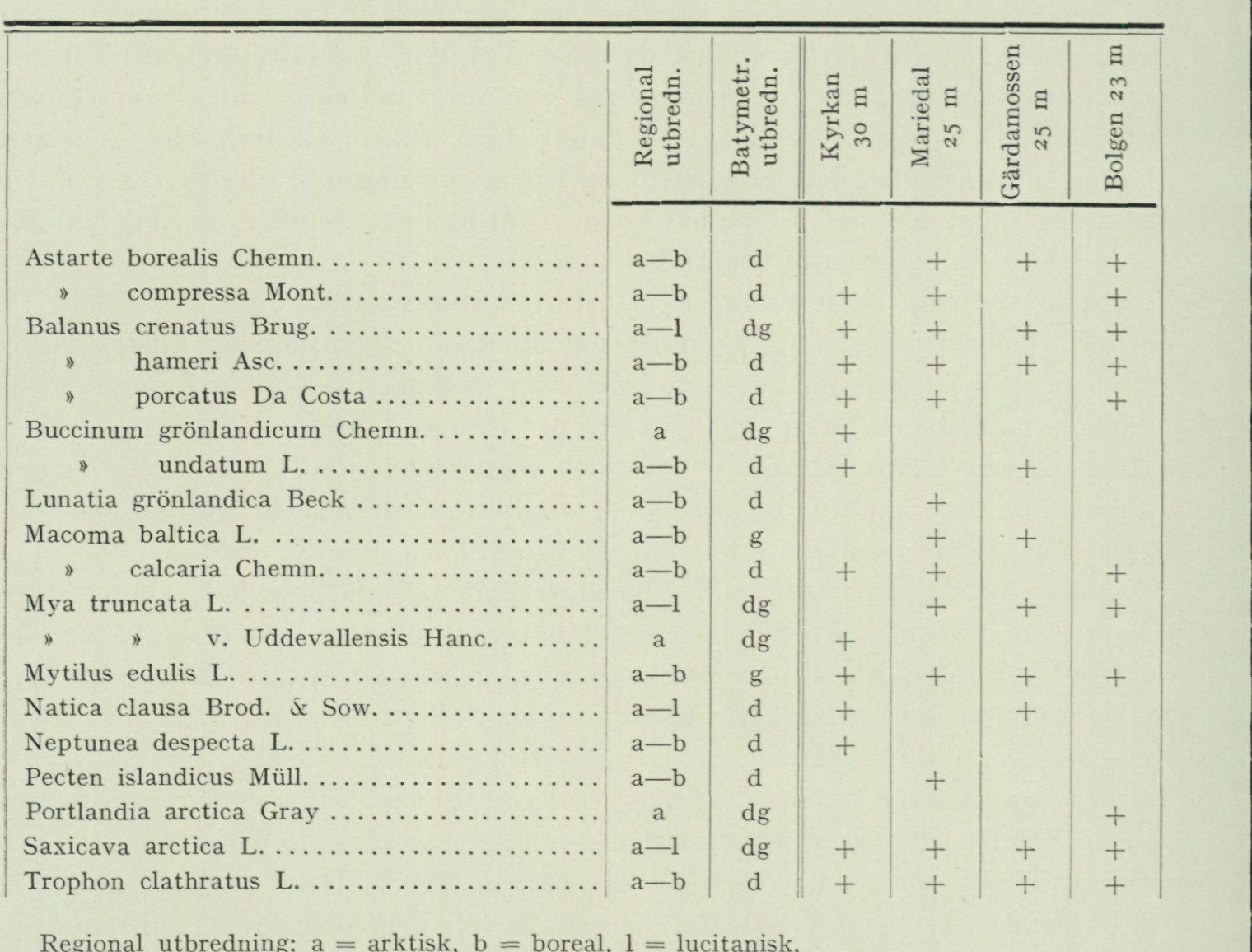
Table V. Lower marine fauna in glaciomarine clay within the Onsala map sheet
| Species | Regional distribution | Bathymetric distribution | Kyrkan, 30 m | Mariedal, 25 m | Gärdamossen, 25 m | Bolgen, 23 m |
|---|---|---|---|---|---|---|
| Astarte borealis Chemn. | a–b | d | + | + | + | |
| Astarte compressa Mont. | a–b | d | + | + | + | |
| Balanus crenatus Brug. | a–l | dg | + | + | + | + |
| Balanus hameri Asc. | a–b | d | + | + | + | + |
| Balanus porcatus Da Costa | a–b | d | + | + | + | |
| Buccinum grönlandicum Chemn. | a | dg | + | |||
| Buccinum undatum L. | a–b | d | + | + | ||
| Lunatia grönlandica Beck | a–b | d | + | |||
| Macoma baltica L. | a–b | g | + | + | ||
| Macoma calcaria Chemn. | a–b | d | + | + | + | |
| Mya truncata L. | a–l | dg | + | + | + | |
| Mya truncata var. Uddevallensis Hanc. | a | dg | + | |||
| Mytilus edulis L. | a–b | g | + | + | + | + |
| Natica clausa Brod. & Sow. | a–l | d | + | + | ||
| Neptunea despecta L. | a–b | d | + | |||
| Pecten islandicus Müll. | a–b | d | + | |||
| Portlandia arctica Gray | a | dg | + | |||
| Saxicava arctica L. | a–l | dg | + | + | + | + |
| Trophon clathratus L. | a–b | d | + | + | + | + |
Regional distribution: a = arctic, b = boreal, l = lusitanian. Bathymetric distribution: d = deep-water, g = shallow-water, dg = species living in both deep and shallow water, according to Antevs, G.F.F., vol. 50, 1928.
    N near Gärdamossen, Vallda parish, approximately 25 m a.s.l., shell-bearing clay
       has been exposed during ditch digging.
     SE of Bolgen, approximately 23 m a.s.l., the drainage ditch cuts through shell-bearing clay over a distance of a
     couple of hundred metres.
      Other localities where shells have been observed in glaciomarine clay during mapping are in Onsala
      parish: S of Häcklehagen, the eastern shore of Öckerö, NE and NW of Råö,
   SW of Rörvik, at N. Hagen, N of Skällared; in Vallda parish: SE of Gräppås,
  NW of Lunnaled (see the map).
Beach gravel When the area had been freed from the ice, the sea covered as mentioned above all present and sand. land within the Onsala sheet except the highest peak of Hylteråsen. During the ongoing land uplift, whereby the shoreline gradually shifted downward, the waves attacked the unconsolidated soil layers. The rocky heights were to a large extent washed bare. Only boulders of such size and weight that they could not be moved by the waves were left behind there, and of finer-grained soils remnants are encountered only in crevices and sheltered depressions. The material washed down from the heights was deposited on the lower parts of the slopes in the form of beach gravel, farther out as sand, which thereby to a large extent
came to cover the previously deposited glacial marine clay. The finest suspended material, finally, was bottom-deposited first in deeper and calmer water farther away from the then-existing shoreline and is now found as postglacial clay within the lowest parts of present-day valleys and plains.
Beach gravel has a wide distribution within the Onsala map sheet. However, only a few of these occurrences reach such an area that they could be specially marked on the map. The situation is, in fact, that practically all areas designated as sand at the boundary against rising till and bedrock are surrounded by quite narrow, often only some 10 m wide zones of beach gravel. Such zones also occur in many places where the map shows clay right up to the till or bedrock. Furthermore, as mentioned above, the areas designated as till on the map are in many places covered by a thin layer of beach gravel. In some places where the beach gravel layer is not too thin, it has been exploited for gravel extraction, e.g. on the Iserås till W of the road Kungsbacka—Gottskär. Such old gravel pits are always quite shallow. The great demand for gravel caused by the extensive road improvements of our days has led to the use of till material for road construction. The gravel pits are then made deeper, which provides the opportunity to study, in larger sections, both the internal structure of the till and the mantle of wave-washed gravel and beach gravel resting on the till.
The main mass of the Onsala sheet’s beach gravel and sand was deposited in postglacial time and will therefore be described in the chapter on the postglacial formations. However, there is a considerable amount of beach gravel that was formed during the rapid regression in late-glacial time and that contains fossils of arctic marine organisms characteristic of this period. Such beach gravel occurs mainly within the areas situated above the postglacial transgression limit, where the material has not been subject to redeposition in postglacial time.
The fossil content of the beach gravel consists of shells of molluscs and other marine Shell gravel organisms. In places, such shells composed of lime constitute the main mass of the banks. gravel, in which case it is termed shell gravel. Shell gravel accumulations of greater thickness are called shell gravel banks.
Shell gravel banks are always found immediately below steep slopes, never out in the middle of the plains. They have originated through mechanical enrichment of shells, when shell-bearing clays are lifted by land uplift to levels reached by the erosion of breakers, which is effective even at considerable depth. The clay has been washed away to be redeposited in calm water at greater distance from the erosion-exposed shore. The shells have, together with gravel and sand, been successively moved down during the regression, until they came to rest in places in the terrain from which they could not be transported to still lower levels. During the downslope transport, shells have accumulated from animals that lived at different times and at different depths. In this process, shells that had been embedded in destroyed, older deposits have been mixed with shells belonging to the fauna living at the time of the bank’s deposition. In a shell gravel bank, therefore, a part of the material always consists of redeposited shells, which may have undergone a perhaps repeatedly recurring transport. This is evidenced by their worn and fragmentary condition. The occurrence of arctic species
               in postglacial shell gravel, which moreover hosts a rich, warmth-demanding fauna, is
       thus due to the shells of the arctic species having been eroded out from previously deposited late-glacial clays or shell gravel banks and redeposited in postglacial time.
        No larger shell gravel banks occur within the Onsala sheet, and the shell gravel deposits present here are quite insignificant. The largest known occurrence, at Råö in Onsala parish, is now completely excavated. The following occurrences of late-glacial shell gravel have been investigated.
    Dammet, Vallda parish, strongly sand-mixed shell gravel, 36 m a.s.l., below a till slope SE adjacent to a small peatland.
     Staregården, Onsala parish. S of the farm, below the northeast slope of the church till, c. 30 m a.s.l., in 1948 a small gravel pit showed at the top 30—50 cm shell-free beach gravel and below that shell gravel with thin layers of clay.
    N of Store mosse, Vallda parish, near the northern map sheet boundary, E adjacent to the bedrock with the elevation figure 56, and c. 25 m a.s.l., a small section showed 60 cm shell-free sand and below that strongly disintegrated shell gravel.
     G r u n s e n, Vallda parish, c. 15 m a.s.l. below a bedrock slope SE of the farm.
       Also in the beach gravel occurring in a narrow crevice between the bedrock hills W of Rörvik, late-glacial shell gravel is present.
        Tab. VI provides a list of the marine fauna found in both late-glacial and postglacial shell gravel within the Onsala sheet. The occurrences of postglacial shell gravel are treated in the chapter on the postglacial formations.
         Regarding the immigration of the various species and the changes in faunal composition during late-glacial and postglacial time, reference is made partly to p. 92—96, and partly to the account given in Description of the Map Sheet Göteborg, S. G. U. Ser. Aa. No. 173, p. 126—133, which is based on a much richer material than that offered by the Onsala sheet.
Postglacial formations.
During the rapid land uplift that took place in late-glacial time, after the area was freed from ice, an arctic climate still prevailed, as evidenced by the fauna in the late-glacial sediments. The climate, however, gradually became milder and milder, and the sediments deposited when the transgression set in testify, through their fossil content, that the postglacial period had then begun. The following is an account of the area's postglacial deposits and of the development that took place during postglacial time.
Postglacial After the considerable regression that occurred in late-glacial time, the rise of the limit. sea level took place, which shifted the shoreline upward, until the continental ice sheets, under the influence of the mild climate prevailing during the Stone Age, had melted away to an extent substantially greater than in our days. At the level to which the sea reached at the transgression maximum, the postglacial limit was formed. This shoreline has been determined in the field and levelled at several locations
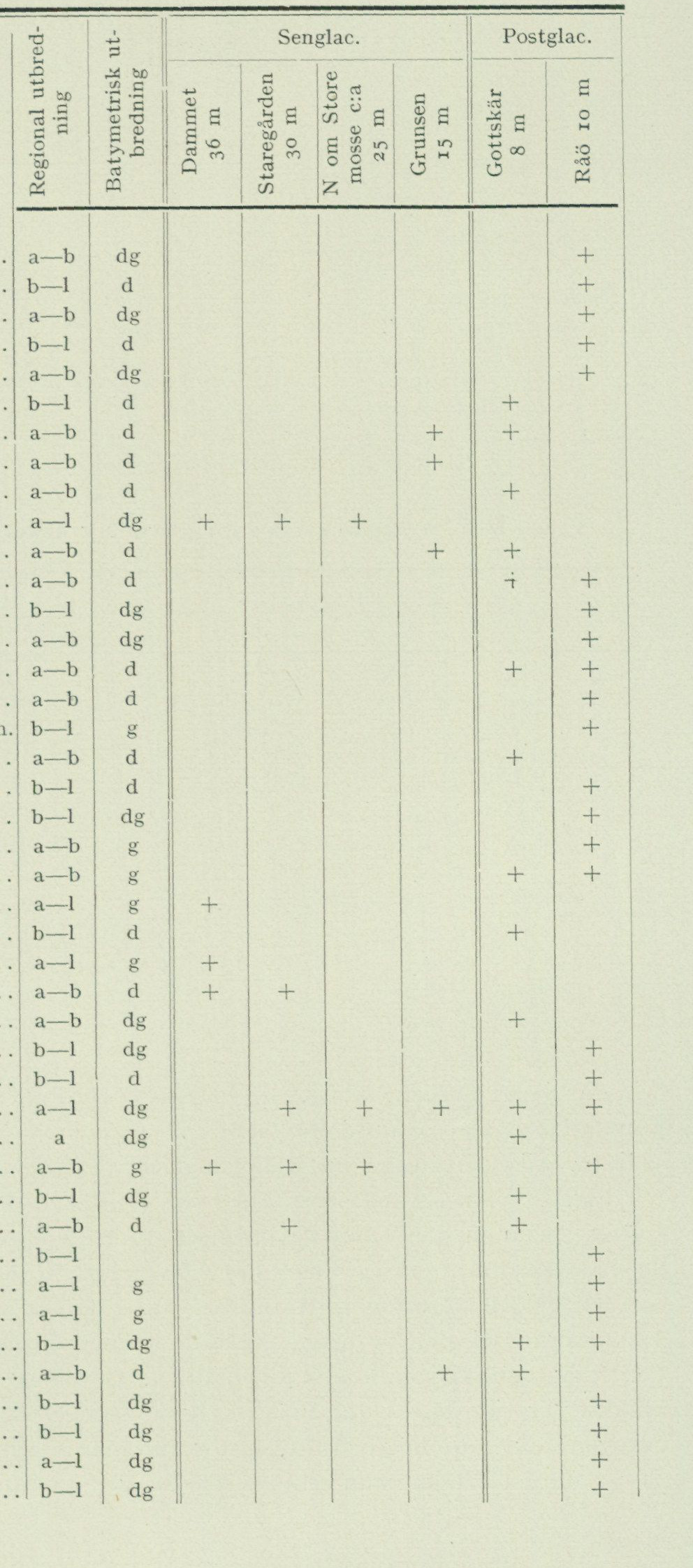
Table VI. Lower marine fauna in shell-gravel deposits within the Onsala map sheet
| Species | Regional distribution | Bathymetric distribution | Late-glacial: Dammet, 36 m | Late-glacial: Staregården, 30 m | Late-glacial: N of Store mosse, ca. 25 m | Late-glacial: Grunsen, 15 m | Postglacial: Gottskär, 8 m | Postglacial: Råö, 10 m |
|---|---|---|---|---|---|---|---|---|
| Acmaea virginea Müll. | a–b | dg | + | |||||
| Alvania punctura Mont. | b–l | d | + | |||||
| Anomia aculeata L. | a–b | dg | + | |||||
| Anomia patelliformis L. | b–l | d | + | |||||
| Anomia squamula L. | a–b | dg | + | |||||
| Aporrhais pes pelecani L. | b–l | d | + | |||||
| Astarte borealis Chemn. | a–b | d | + | + | ||||
| Astarte compressa Mont. | a–b | d | + | |||||
| Astarte elliptica Brown | a–b | d | + | |||||
| Balanus crenatus Brug. | a–l | dg | + | + | + | |||
| Balanus hameri Asc. | a–b | d | + | + | ||||
| Balanus porcatus Da Costa | a–b | d | + | + | ||||
| Bittium reticulatum Da Costa | b–l | dg | + | |||||
| Boreochiton marmoreus Fabr. | a–b | dg | + | |||||
| Buccinum undatum L. | a–b | d | + | + | ||||
| Cardium fasciatum Mont. | a–b | d | + | |||||
| Craspedochilus marginatus Penn. | b–l | g | + | |||||
| Cyprina islandica L. | a–b | d | + | |||||
| Emarginula fissura L. | b–l | d | + | |||||
| Gibbula cineraria L. | b–l | dg | + | |||||
| Lacuna divaricata Fabr. | a–b | g | + | + | ||||
| Litorina litorea L. | a–b | g | + | + | ||||
| Litorina rudis Maton | a–l | g | + | |||||
| Lucina borealis L. | b–l | d | + | |||||
| Macoma baltica L. | a–l | g | + | |||||
| Macoma calcaria Chemn. | a–b | d | + | + | ||||
| Modiola modiolus L. | a–b | dg | + | |||||
| Modiolaria discors L. | b–l | dg | + | |||||
| Montacuta bidentata Mont. | b–l | d | + | |||||
| Mya truncata L. | a–l | dg | + | + | + | + | + | + |
| Mya truncata var. Uddevallensis | a | dg | + | |||||
| Mytilus edulis L. | a–b | g | + | + | + | + | + | |
| Nassa reticulata L. | b–l | dg | + | |||||
| Neptunea despecta L. | a–b | d | + | + | ||||
| Nucula nitida Sow. | b–l | [illegible] | + | |||||
| Onoba proxima Alder | a–l | g | + | |||||
| Onoba striata Mont. | a–l | g | + | |||||
| Ostrea edulis L. | b–l | dg | + | + | ||||
| Pecten islandicus Müll. | a–b | d | + | + | ||||
| Retusa truncatula Brug. | b–l | dg | + | |||||
| Rissoa inconspicua Ald. | b–l | dg | + | |||||
| Rissoa interrupta Ad. | a–l | dg | + | |||||
| Rissoa violacea Desm. | b–l | dg | + |
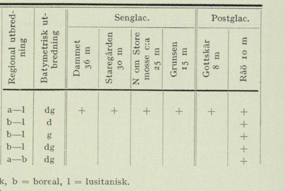
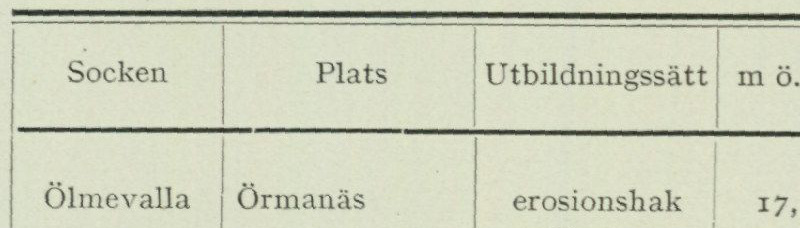
Table VI (continued)
| Species | Regional distribution | Bathymetric distribution | Late-glacial: Dammet, 36 m | Late-glacial: Staregården, 30 m | Late-glacial: N of Store mosse, ca. 25 m | Late-glacial: Grunsen, 15 m | Postglacial: Gottskär, 8 m | Postglacial: Råö, 10 m |
|---|---|---|---|---|---|---|---|---|
| Saxicava arctica L. | a–l | dg | + | + | + | + | + | + |
| Syndosmya alba Wood | b–l | d | + | |||||
| Tapes pullastra Mont. | b–l | g | + | |||||
| Triphoris perversa L. | b–l | dg | + | |||||
| Verruca strömia Müll. | a–b | dg | + |
Regional distribution: a = arctic, b = boreal, l = lusitanian. Bathymetric distribution: d = deep-water, g = shallow-water, dg = species living in both deep and shallow water, according to Antevs, G.F.F., 1928.
Table VII. Leveling of the postglacial limit within the Onsala map sheet
| Parish | Place | Formation | Metres above sea level | Observer | Leveling instrument |
|---|---|---|---|---|---|
| Ölmevalla | Örmanäs | Erosion notch | 17.1 | H. Thomasson, 1931 | Tube level |
| Ölmevalla | Örmanäs | Beach-ridge crest | 19.4 | H. Thomasson, 1931 | Tube level |
| Onsala | Hållsunds udde, eastern side | Beach-ridge crest | 19.5 | H. Thomasson, 1933 | Tube level |
| Onsala | Hållsunds udde, western side | Beach-ridge crest | 19.75 | H. Thomasson, 1933 | Tube level |
| Onsala | Gottskär | Erosion notch | 19.5 | J. Alin, 1917 | Tube level |
| Onsala | Onsala Parsonage | Beach-ridge crest | 19.7 | J. Alin, 1917 | Tube level |
| Onsala | Onsala Parsonage | Beach-ridge crest | 19.5 | R. Sandegren, 1948 | Mirror level |
| Onsala | Meryt | Beach-ridge crest | 19.5 | R. Sandegren, 1948 | Mirror level |
| Onsala | V. Hagen | Beach-ridge crest | 20.0 | H. Thomasson, 1935 | Mirror level |
| Onsala | Prässe | Erosion notch | 20.6 | J. Alin, 1917 | Tube level |
within the map sheet Onsala, see fig. 32 and tab. VII. Fig. 32 shows how the Onsala peninsula during the Stone Age was divided into a number of larger and smaller islands and how deep bays penetrated into the valleys. Fig. 33 shows the beach ridge at Onsala parsonage. The ridge dams off the valley basin, which between the Onsala church moraine and the nearest moraine ridge N of it runs from the parsonage towards ESE down to Kungsbackafjorden. The beach ridge at Meryt occupies an analogous position in the basin between the northern of the Vickan- moraines and the bedrock-controlled drumlin height to the NE. Alin in Sarauw and Alin: Götaälvsområdets fornminnen, Göteborg 1923, p. 66, provided a depiction of the erosion notch at Prässe, taken in 1917. Since then, however, the fir forest has grown up tall and dense, so that one can no longer obtain the overview of the shoreline in question that was afforded before the forest was planted.
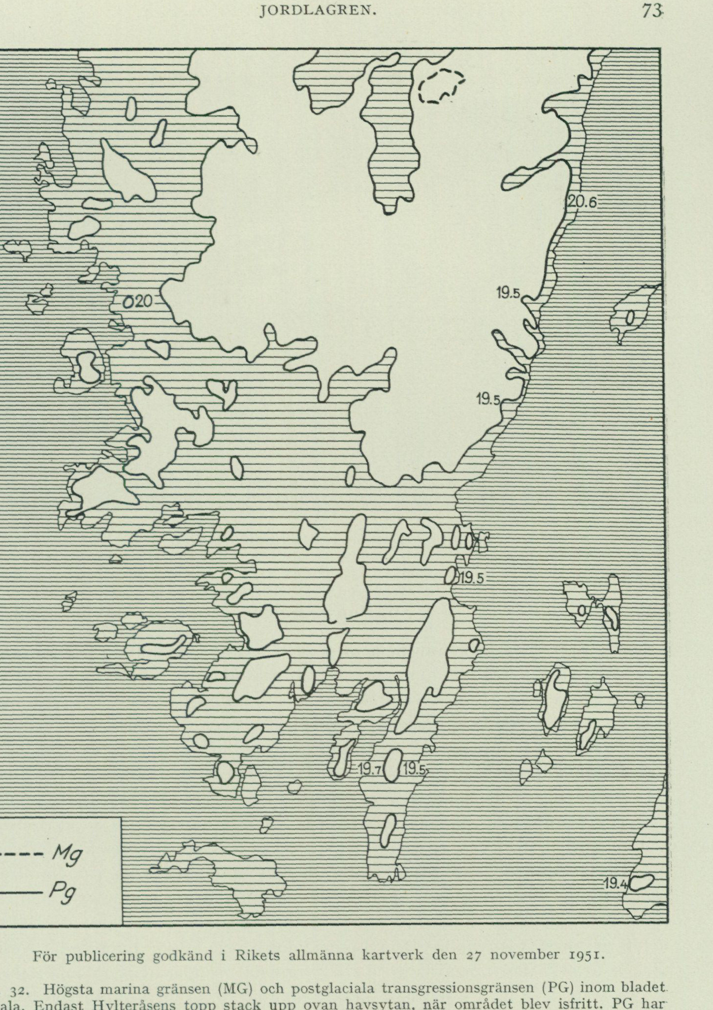
Approved for publication by the National Land Survey of Sweden on 27 November 1951.
Fig. 32. The highest marine limit (MG) and the postglacial transgression limit (PG) within the map sheet Onsala. Only the summit of Hylteråsen protruded above sea level when the area became ice-free. PG has been plotted, with the support of the leveled points, which are marked at the respective localities, according to the elevation figures on the topographic map. Land areas situated below PG have been marked with sparse hatching; the present-day sea is shown with denser hatching. R. Sandegren 1951.
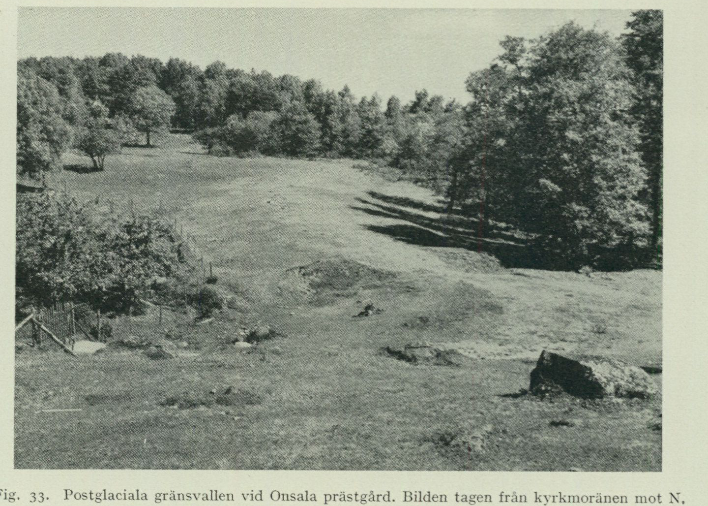
Fig. 33. Postglacial raised beach ridge at Onsala parsonage. The photograph was taken from the church toward the N. G. Lundqvist photo 1951.
Marine sediments.
Postglacial The postglacial clay, which has been distinguished on the map with a clay. special designation, constitutes the area’s youngest marine deposit and is therefore encountered only within the lowest parts of the valley floors, from the present sea level and up to 12 m a.s.l. (in the Lunna area in Vallda parish). All occurrences thus lie considerably below the postglacial transgression limit (c. 19 m a.s.l.). In contrast to the stiff clays described above and designated on the map as Baltic Sea clay, the postglacial clays are soft clays. They are rich in organic material, above all gyttja material, and therefore often have the character of gyttja clays. Furthermore, the grain size is coarser, in that the main mass consists of silt and fine sand. This is the reason why they appear as soft clays in relation to the older, stiff clays. In the deeper layers the colour is sometimes almost black, but in most cases they are characterised by light grey-brown or yellow-brown colour tones. The thickness is highly variable. The boreholes carried out in Lunna mosse and east of Lunnaled in Vallda parish yielded thicknesses of 2.8 and 1.13 m, respectively, for the postglacial clay present there. A closer description of these interesting stratigraphic sequences is given in the chapter “Peatlands”, pp. 84—92. Since the postglacial clay is a shore-erosion sediment, where the main mass consists of material washed down from the shores during the postglacial regression, the layers attain their greatest thickness near the former shore, but become thinner farther out from it. Surprisingly great thickness can be reached by the postglacial clay in narrow valleys that during postglacial time constituted fjords,
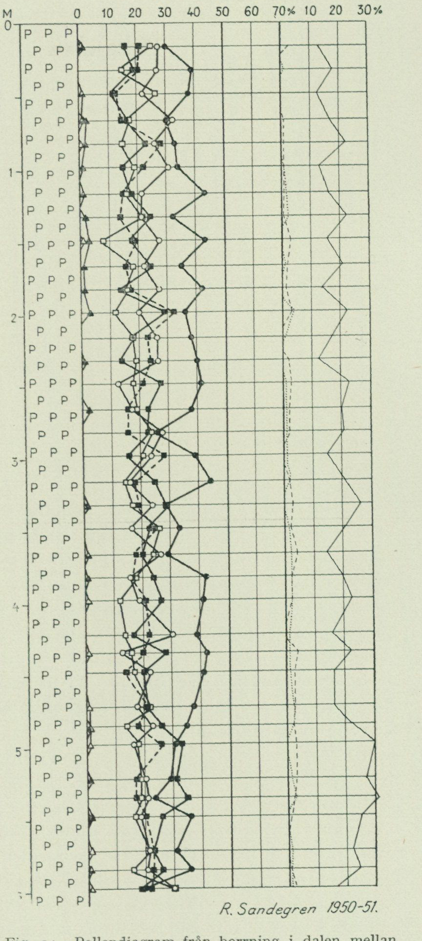
where material in abundant quantity was washed out from the shores of both sides of the fjord. An example of this is provided by a borehole carried out in 1948 in the middle of the valley between Hult and Häcklehagen in Onsala parish. The drilling site is located next to the main ditch running through the valley, where the ground surface is situated at c. 2 m a.s.l. The borehole, which was driven down to a depth of 6 metres, passed all the way through postglacial, light grey soft clay without reaching its substratum. Fig. 34 is a pollen diagram based on samples collected during this borehole. From the diagram it is apparent that this entire 6 m thick clay belongs to the latest part of postglacial time, which is characterised by the presence of spruce, beech, and hornbeam, and by the strong dominance of oak over the other noble broadleaf trees, lime and elm (see below p. 95). Barely 2 km N of here, at the ditch junction 800 m SW of Heden, where the ground surface lies at c. 1 m a.s.l., another borehole was carried out. Here, as is apparent from the pollen diagram fig. 35, the entire thickness of the postglacial clay is little more than 3 m and its uppermost, spruce-pollen-bearing zone barely 0.5 m. The great difference in thickness of the youngest, spruce-pollen-bearing zone at these R. Sandegren 1950—51. fairly closely Fig. 34. Pollen diagram from a borehole in the valley between situated localities is probably Hult and Häcklehagen, Onsala parish. Symbols as explained by the fact that the in fig. 35. former, as mentioned above, lies in a narrow valley that, at the time of deposition of the sediment in question, constituted a fjord with relatively high shores, while the latter lies in the middle of the map sheet’s largest plain area, at a distance of just over 1 km from the nearest contemporary shore.
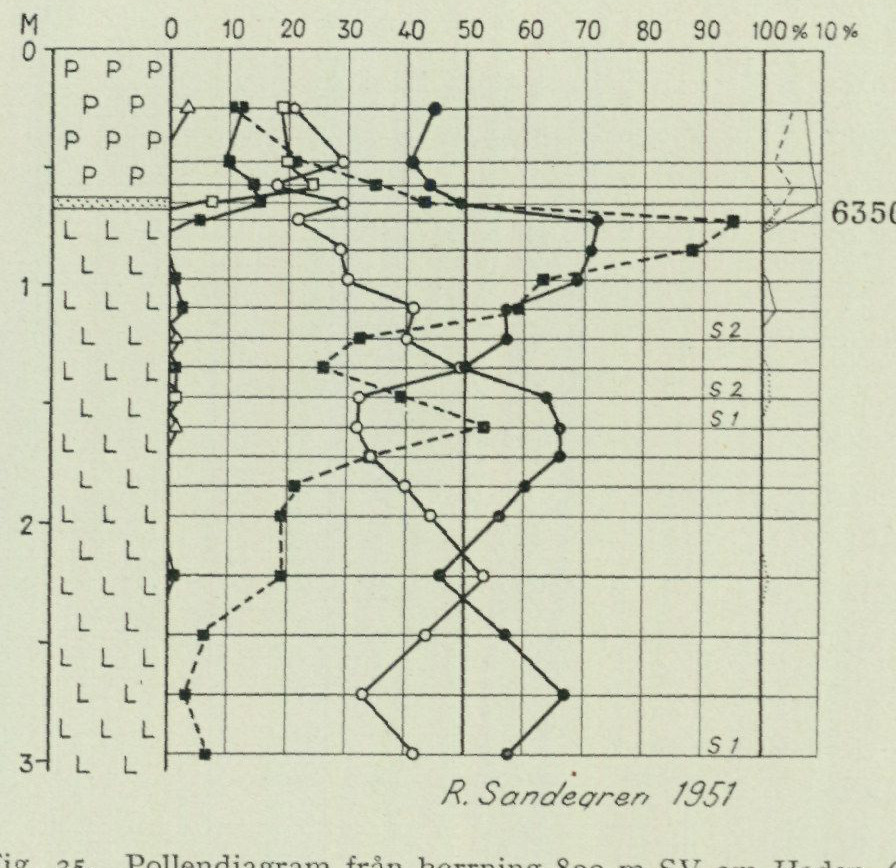
Pollen-frequency scale: 0–100%; auxiliary scale: 10%.
                                                                                  Picea

                                                                            fagus

                                                                                  Carpinus
                                                     6350 B.C.            Pinus
                                    —o— Betula
                                   —□— Alnus

                                                               —  ■ «>    Salix
                                    —*—  Oak-pine forest
                                                                                                                         --------- Quercus
                                                                                   ------ Tilia

                                                                        Ulmus

                                                                         C    Carpinus

                                                                     F   fagus

                                                                     S   Salix
                                                                                                             --- ■----Corylus
R. Sandegren 1951
          Fig. 35. Pollen diagram from boring 800 m SW of Heden, Onsala parish. P = postglacial marine clay. Dots = sand. L = stiff clay, the uppermost part of which belongs to Boreal time, but which downward passes into glacial-marine clay.

      Because only quite small samples, obtained through borings, have been available for closer examination, the marine mollusc fauna observed in the postglacial clays within the Onsala sheet comprises only a few species. Thus, in the borings in Lunna mosse and E of Lunnaled, Cardium edule and Mytilus edulis were observed, and in the boring NE of Häcklehagen, Cardium edule. The postglacial shell-gravel banks, on the other hand, give a fuller picture of the rich mollusc fauna of postglacial time; see Table VI. In a sample of postglacial clay from a ditch within the Kungsbacka town area, Aporrhais pes pelecani, Cardium edule, and Nassa reticulata were found. Within the Särö sheet, samples of postglacial clay with very rich fauna have been collected from a number of localities.
Beach gravel The greater part of the beach gravel and sand occurring within the Onsala and sand. sheet has, as mentioned above, been deposited during postglacial time. In the central parts of the larger sand areas, the sand reaches a thickness of one or a few metres and rests on glacial-marine clay, which is often shell-bearing. This is the case, for example, at Knaperyd, NW of Råö, SW and N of Rörvik in Onsala, and around Hornarp in Vallda parish. Toward the slopes, sand or beach gravel lies directly on till. Thus, W of Rydet, in 1948, a section immediately E of the main road showed 1 m sand on till, while excavation for a new house SW of the same road revealed 2 m sand, which downward passed into stratified gravel with the strata dipping away from the height situated to the NE. Beach gravel occurs in many places in association with the sand, most commonly as narrow zones at its boundary against the heights composed of till and bare rock. In most cases this beach gravel has such a small area that it could not be separately delineated
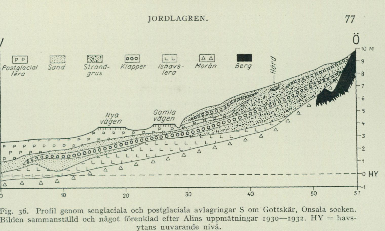
Fig. 36. Profile through late-glacial and postglacial deposits S of Gottskär, Onsala parish. The figure compiled and somewhat simplified after Alin’s surveys 1930—1932. HY = the present level of the sea surface.
on the map. Among the occurrences marked there, one may be mentioned N of Lerkil, where the material consists of fist-sized, rounded stones and coarse sand. Another, immediately NW of V. Hagen, forms a beach spur extending NE from the height situated in W, which consists of bedrock and till. The gravel resources here, which together with the till are exploited for gravel extraction, will however probably be exhausted within a not too distant future. The glacially polished bedrock surface exposed by the gravel extraction, however, offers particularly interesting details for the interpretation of the bedrock, see fig. 9—10 and 16—18. In terms of Quaternary geology, two occurrences of beach gravel, one S of Gottskär, the other at Råö, are of great interest and therefore deserve a closer description.
Gottskär
On the western slope of the ridge that runs along Kungsbackafjorden approximately 500 m SW of Gottskär, beach gravel occurs as a narrow border between the bedrock and the clay field situated in W. Due to its insignificant area, the gravel could not be separately marked on the map. J. Alin¹ has in detail surveyed two profiles through the deposits here. In fig. 36 the main features of the facts obtained from Alin’s surveys are reproduced schematically. The gravel occurrence has been utilized for road construction. Alin observed already in 1917 that the gravel contained Stone Age implements, which must originate from a settlement. This gave rise to his investigation. The profile shows a number of different layers, which occur as beds dipping away from the bedrock (fig. 36). The glacial marine clay resting on the till contains shells of exclusively late-glacial species such as Astarte borealis, A. elliptica, Balanus hameri, Mya truncata and Saxicava arctica. The sand resting directly on the lower shingle layer, which can be followed throughout the entire profile, by contrast contains a fauna characterized by Ostrea edulis and other postglacial species, but also some late-glacial species. The entire fauna found here
¹ Alin, Johan: Strandlinjens läge i Göteborgstrakten vid slutet av den senglaciala landhöjningen. Gbg:s K. Vet.- o. Vitt. Samh. Handl. 5. F. Ser. B. Bd 4. N:o 2. Göteborg 1934.
is reported in tab. VI. On these lower gravel layers rests a layer of postglacial marine clay pinching out towards E, which towards W, in the centre of the valley, grades upward into clay gyttja. In E the postglacial clay is overlain by beach gravel and shingle. Diatom analyses and pollen analyses, carried out on samples from different parts of the clay and gyttja layers for their dating, have been published in Alin’s work. Worked flint flakes and artefacts have been found in all layers within the eastern half of the profile, right from the contact between glacial marine clay and gravel up to the ground surface. In the layers underlying the postglacial clay, however, there are exclusively objects from the Older Stone Age, such as flake axes and core axes. In the gravel overlying the same clay, on the other hand, along with flake axes, also arrowheads belonging to the passage-grave period and fragments of a polished, probably thick-butted flint axe have been found. In addition, hearths were found in the upper shingle layer, which were covered by sand and gravel.
The stratigraphic sequence bears witness to the following development. When the ice melted away, the entire area lay below sea level and glacial marine clay was deposited as a covering blanket on the then sea floor. When, due to land uplift, the regression of the sea level had progressed so far that the height situated immediately E of the illustrated profile, which now reaches 30 m a.s.l., was lifted up within the zone of wave action, the washing away of the clay and till lying on the crest began. The material was deposited on the slope and at its foot as beach gravel and shingle. Towards W the beach gravel and shingle layer pinch out and are finally replaced by sand alone. The occurrence of artefacts already in the lowermost part of the beach gravel demonstrates that humans had arrived in the area already during the later part of late-glacial time and settled on the island here emerging from the sea. The regression should, by all appearances, have progressed so far that the shore during the former part of the Ancylus period at Gottskär was situated approximately 7 m above the present sea level. Down to this level the settlement of the Older Stone Age could take place. Alin reckons that the shore lay even somewhat lower, but secure evidence for this appears to be lacking. When the postglacial transgression commenced, the ground at the settlement sites was successively undermined by shore erosion. Sand and gravel along with artefacts were washed down the slope and gave rise to the sand layer resting on the lower shingle. In this were also embedded shells of the then immigrated postglacial, warmth-demanding marine fauna together with shells that had been washed out from the eroded glacial marine clay during the regression. As the sea level rose, the Stone Age people were forced to move higher up and finally had to take refuge at the levels immediately above the postglacial transgression limit. In the increasingly deeper water, deposition of postglacial clay commenced. Its upward pinch-out lies in the profile approximately 6 m above the present sea level. At least this high up on the slope, clay was deposited at the maximum of the transgression, when the shore here stood approximately 19 m higher than it does today.
When regression again occurred, sand and finally shingle were washed down onto the clay deposited in the slope. The Stone Age people moved back down onto the drained shingle shore, which is evident from the hearths established there. During the passage-grave period a renewed, minor transgression occurred, which here should have reached up to approximately 10 m above the present sea level, and thereby the relevant
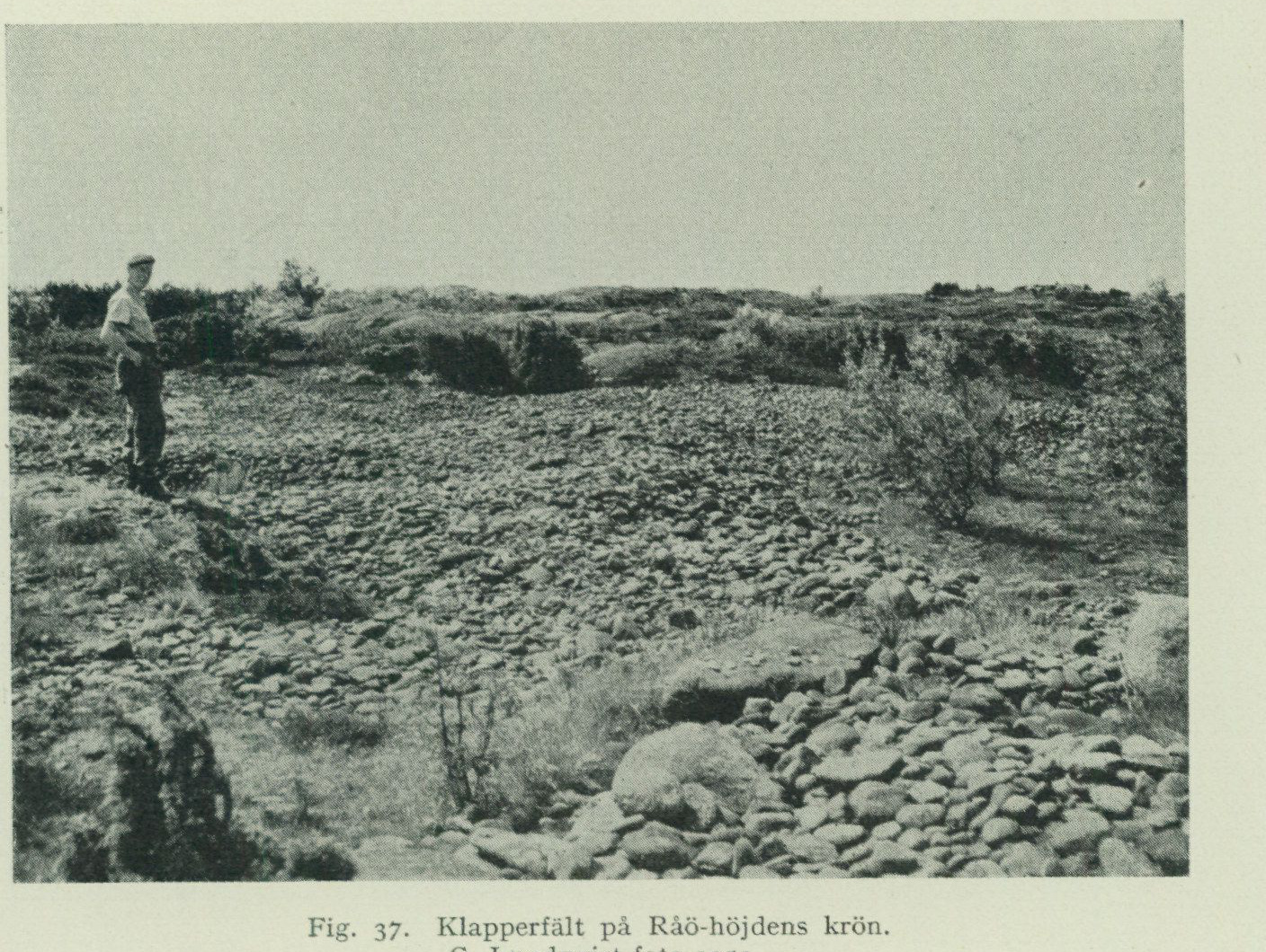
Fig. 37. Shingle field on the crest of the Råö height. G. Lundqvist photo 1951.
the hearths were covered with sand. Finally, the last regression commenced, during which the shoreline gradually moved down to its present position (see fig. 46). During this stage, the marine bay, which was becoming progressively smaller in area, occupied such a sheltered position that only fine mud could be washed down. This now forms part of the uppermost layer of the postglacial clay gyttja occurring in the middle of the valley.
Råö is no longer an island, but the name lives on from the not-too-distant time when the height SW of the present farm was separated from Fjärhals, located to the N, by a strait, now occupied by low-lying, cultivated sandy land. The Råö height, whose crest reaches 17 m a.s.l., has a core of bedrock, which appears in 3 larger exposures. Otherwise, it consists of till, which to a great extent has been reworked into shingle and beach gravel. The surface of the height plateau itself constitutes a field of coarse shingle and boulders up to 1 metre in diameter (fig. 37). At the NE end of the height, immediately adjacent to the farm, there was in the summer of 1948 a gravel pit whose approx. 5 m high wall, beneath a wash-gravel cover consisting of sand, gravel, and coarse cobblestones, exposed a postglacial shell-gravel bank. The shell gravel had a thickness of approx. 1.5 m in the section then available and was mixed with gravel and cobblestones ranging from tennis-ball to football size. The upward pinch-out of the shell-bearing layer was found to lie at approx. 10 m a.s.l. The shells were to a very large extent finely crushed. Collected samples contained the fauna reported in tab. VI. Upon a renewed visit to the site in the summer of 1949, the gravel pit was found to have advanced and the shell-gravel layer had been completely removed. The wall of the gravel pit then showed only coarse gravel and cobblestones of an appearance that
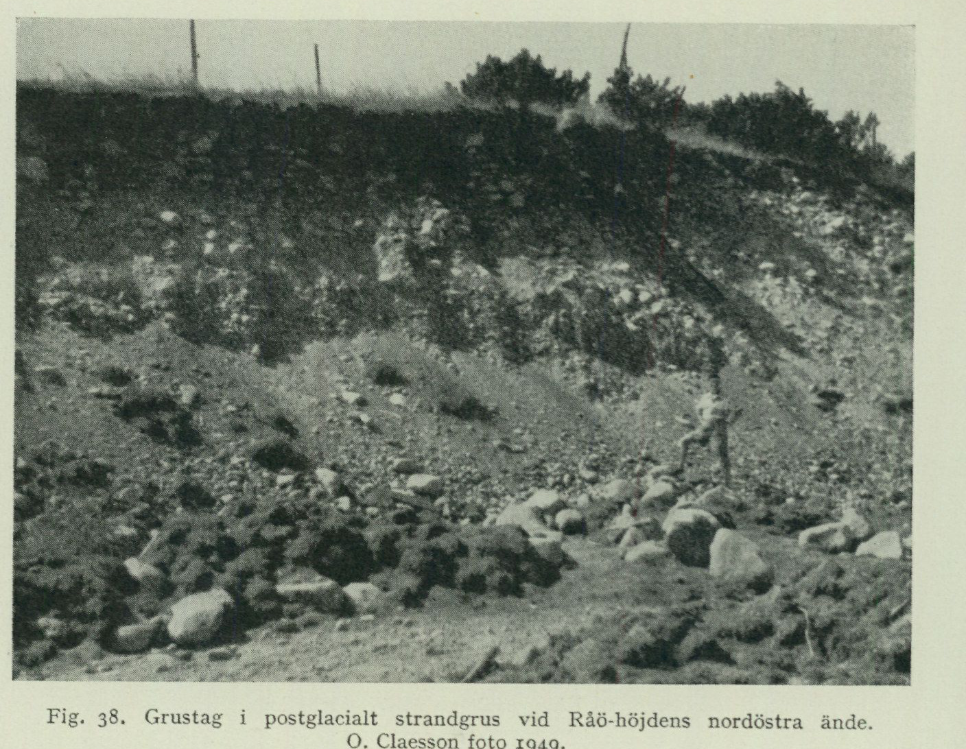
    Fig. 38.  Gravel pit in postglacial beach gravel at the northeastern end of the Råö height.
                               O. Claesson photo 1949.
aroused suspicion that the material could possibly consist of glaciofluvial gravel (fig. 38). A closer investigation demonstrated, however, that no discordant bedding was present in the gravel, but only the usual beach-gravel bedding dipping away from the height. Furthermore, beneath boulders of the size that in fig. 38 lie loose on the ground in the foreground and which were dug up in situ from the bottom of the gravel pit, crushed shells of postglacial species were found, inter alia Cardium edule. The entire gravel mass, at least 5 m thick, thus consists of postglacial beach gravel. These observations bear eloquent witness to the extensive effect of marine abrasion at an open coast. After the crest of the Råö height was lifted by land uplift into the zone of wave action, vast quantities of material were removed from there and, under the influence of the prevailing southwesterly winds, cast down the slope at the NE side of the height. When land uplift had progressed so far that the crest of the height formed a shoal approaching the water surface, this provided some degree of lee, so that even the lighter material composing the shell-gravel bank remained in place. The larger stones incorporated in the shell gravel, which were presumably brought there during stronger storms, provide an explanation for the strikingly strong crushing exhibited by the shell material. The wash-gravel cover resting on the shell gravel was finally deposited when Råö became an island and the shoreline gradually shifted down the slopes.
Traces of early Stone Age settlement have also been recorded at Råö. Archaeological investigations, carried out here on the initiative of Råö’s then-owner, the late Major Herbert Jacobsson, have yielded some facts also of geological
interest.1 An excavation carried out at a site on the northwestern slope of the Råö height, where the ground surface lies at 13.3 m a. s. l., passed through 5 m of shell-free beach gravel of the same type as that at Råö farm. The gravel rests on glaciomarine clay containing shells belonging to the common late-glacial fauna. At major Jacobsson’s villa on the southern side of Råö, another excavation was made. From the ground surface, which lies at 7.08 m a. s. l., the following layers were measured: A. 1.07 m beach gravel with occasional fist-sized and larger boulder stones; sharp contact against: B. 0.2 m clay, grey, shell-free, with rust mottling and occasional boulder stones. C. 0.19 m boulders, sandy, grey-brown. D. 0.59 m sand, grey, stone-free, somewhat clayey. E. 0.4 m clay, richly shell-bearing, in places grey-green with occasional stones and flint. F. 0.55 m sand, grey, shell-free, clayey, bearing stones and flint. G. 0.25 m clay, grey-blue, shell-bearing, rich in stone and flint. H. layer of coarse stones (till?)
The fauna occurring in the clay layers E and G is reported to consist of late-glacial species, among which Saxicava arctica dominates. Flint flakes, which Niklasson considers to have been intentionally struck and which would represent very primitive tool types belonging to the earliest Stone Age (scrapers and hand axes), have been found both in the same two clay layers and in the intervening sand layer, F. He further states: “That the place where the flints were now found is not their original place of deposition must be readily apparent. They have been washed out together with other beach material from a nearby shore, on which the settlement site was located.” Furthermore, within minor, well-defined areas on the surface of the Råö height, flint is abundant, partly as blocks and partly as flakes. Of tools, only a core axe and a larger scraper of a form common at low-lying settlement sites along the coast of northern Halland have been found here; this is attributed to the later phases of the Younger Stone Age, the passage-grave period and the gallery-grave period. In the pit mentioned above at the northwest slope of the Råö height, “struck” flint was encountered in the gravel from the surface down to a depth of about 1 m. This material is likely waste from the Younger Stone Age settlement site on the height. H. Thomasson, who collaborated with Niklasson, provides the following interpretation based on the sequence of layers described above at Gottskär. The layers G–D were deposited during the late-glacial regression. The upper part of layer D and the boulder layer C correspond to the Ancylus period (maximum of the regression), the clay layer B belongs to the transgression maximum of the Litorina period (unfortunately, no pollen analysis of the clay has been carried out). Layer A, finally, was deposited during the postglacial regression phase. Should this interpretation be correct, and the “struck” flints found in layers G–E have indeed been worked by human hand and not produced by breakage of flint nodules caused by wave abrasion.
¹ Niklasson, Nils: Råö och Varberg. Ett bidrag till kännedomen om bosättningen i Sverige under senglacial tid. — Arkeologiska studier tillägnade H. K. H. Kronprins Gustaf Adolf. Utg. av Sv. Fornminnesfören. Sthlm 1932.
If so, this would indicate a settlement at Råö at approximately the same time as the earliest at Gottskär. That people lived at Råö during the latest phases of the Stone Age, as at Gottskär and at many other sites on the Onsala landmass, is in any case certain.
Peatlands.
As is apparent from the map, peatlands occupy a rather insignificant area within the Onsala map sheet. However, before the effects of recent decades’ afforestation had made themselves felt, peat played an important role in the fuel supply of the district. The peatlands have therefore been so heavily exploited that the original reserves of extractable peat are now practically exhausted. In many places, for example at Bolgen and at Store mosse between Ledet and Lunnaled in Vallda parish, lake-like bodies of water now occupy the place of the excavated peat. At the elevation figure 20, W of Forsbäck, an impassable quaking bog covers old peat pits. At Lunna mosse and in the valley between Hultet and Häcklehagen in Onsala parish, previously existing peat layers have disappeared, and the underlying postglacial clay now provides an excellent arable soil. Even in places where peat still remains, the uppermost, youngest layers have been dug away, for which reason it has not been possible to obtain any sample series for pollen analysis from the area of the map sheet, by which the postglacial development of the district in its entirety could be illuminated with material from one and the same site. By combining diagrams prepared from sample series taken from peat layers and sediments at several different sites, and by comparing these with a diagram spanning the entire postglacial period, obtained from Kro mosse on the map sheet Särö, however, a reasonably complete picture of the development has been achieved (see pp. 92–96). Peat is formed through the accumulation of dead plant remains at sites where the soil moisture is so great that the plant remains are protected by the water, to a greater or lesser degree, from free access of air and the consequent decomposition processes. Since peat is a product of the plant community living at the site, and this in turn varies according to nutrient availability and climatic conditions such as precipitation and temperature, a peatland will be built up of different peat types formed by different plant communities, which during the growth of the peat succeeded one another at the site and thus bear witness to the development the peatland has undergone. Since the area’s clay and sand soils are rich in lime shells of marine molluscs, the groundwater generally has a comparatively high lime content. The peat therefore consists predominantly of fen peat types (sedge peat, formed from the root felt of various sedge species, and leaf-fen peat, which is rich in woody remains, primarily of alder and birch), whereas the generally lime-avoiding peat mosses (Sphagnum) have contributed little to peat formation. Most of the peatlands in the area have originated through the infilling of former lakes or shallow marine bays, which is evident from the fact that the peat is frequently underlain by gyttjas. Gyttja is formed from bottom-deposited remains of various organisms, such as algae, fruits, seeds, and finely fragmented remains of higher aquatic plants, remains of lower aquatic animals and their excrement, as well as from a more or less prominent
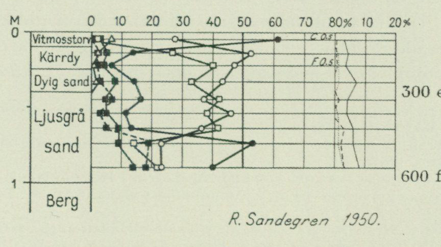
admixture of clay and sand particles. An intermediate between gyttja and clay (clay gyttja) plays a major role among the postglacial sediments. Calcareous gyttja, rich in mollusc shells, occurs in many places. Gyttjas are deposited both in salt and fresh water. Through examination of the fossil organisms contained in gyttjas and clays, primarily molluscs and diatoms, information is obtained as to whether the sediment was deposited in the sea or in lakes.
Further information about the appearance and character of different types of peat and gyttja is provided in the following description of some peatland stratigraphies. These moreover furnish essential facts for elucidating the development of the area with regard to shoreline displacement and vegetation history.
The only peatland within the Onsala map sheet that appears to have escaped exploitation Peatland on is an extremely insignificant one, situated in a depression on Öckerö, which lies off the southwest coast of the Onsala peninsula. Due to the peat’s low thickness it lacks economic significance, but it is of interest in that the youngest layers, removed from all other peatlands, are represented here. The spillway threshold of the basin lies at about 16 m a.s.l. A boring carried out at the eastern end of the small lake showed the following layers:
A. 10 cm yellowish-brown, almost unhumified Sphagnum peat. B. 15 cm dark brown fen peat. C. 15 cm of dark-coloured, dyey sand. D. 60 cm light grey sand consisting of angular mineral grains, derived from little-weathered weathering material. E. bedrock.
Fig. 39 is a pollen diagram from this stratigraphy. A comparison with the pollen diagram from Kro mosse on the Särö map sheet indicates that the RY II level (c. 300 AD) lies in the dyey sand and the RY III level (c. 600 BC) at the base of the grey sand. The diagram is very compressed due to the low thickness of the layers (cf. the diagram fig. 34, where 6 m of postglacial clay represents roughly the same time interval as the uppermost 40 centimetres in the Öckerö diagram). Both the grey and the dyey sand contain exclusively freshwater diatoms of the genera Cymbella, Pinnularia, Stauroneis and Tabellaria. Marine deposits
                     Dyey sand
                                                  300 AD

                                                    600 BC

            Fig.  39.  Pollen diagram from the peatland on Öckerö, Onsala parish.
                           Symbols as in fig.  35.
are thus absent at the boring point. This means that the bedrock lay washed clean by the breakers when the basin's spillway threshold (16 m a.s.l.) was lifted above sea level by land uplift. This occurred during an early stage of the regression from PG (19 m a.s.l.). The sand undoubtedly derives from weathering material that formed during the millennia when the rock surface lay bare and was washed down into the small lake only when the precipitation-rich climate of the sub-Atlantic period set in. Thereafter peat gradually began to form at the shore of the small lake.
Lunna mosse. Lunna mosse formerly occupied a large area within the lowest part of the north–south valley that extends south of Lunna in Vallda parish from Bunn in the south to Hallen in the north. The peat has long since been almost entirely dug away, so that, with the exception of a small area in the centre, postglacial marine clay is exposed at the surface. Despite this, a more detailed account of the stratigraphy must nevertheless be given here, because, as Sernander once wrote: “Lunna mosse is without doubt one of the most interesting mires in western Sweden.” It has namely provided one of the earliest known and, due to the carefully executed investigations, most reliable pieces of evidence for the postglacial marine transgression that affected the southern parts of our country.
Lunna mosse was first described by Gunnar Andersson in 1893 and by Sernander in 1902. Later it was studied by Halden in 1922 and by H. Thomasson in 1934 using more modern methods. No renewed investigation in connection with the reconnaissance of the Onsala sheet was therefore considered justified; instead, the account given here has been compiled mainly on the basis of the existing literature.¹ The interpretation of facts is, however, in certain respects based on the author’s own observations² within the map sheets Göteborg, Särö and Onsala, which explains the deviation regarding certain dating questions that appears in my presentation compared with that given by Thomasson.
The threshold of the Lunna mosse basin lies at 12 m and the surface of the peat layer still remaining in 1934 in its central part at 12.5 m a.s.l. Fig. 40 shows a profile running west to east, intersecting the main north–south ditch about 340 m south of the point where the road running from southwest to northeast crosses the same ditch. The character of the various layers is given here in brief summary, from bottom to top, together with information on the most important fossils found therein.
Marine clay. This is grey in colour and has, at the main ditch, 140 m north of the profile shown in fig. 40, a thickness of 3 m. It rests on a stony deposit, probably till. The clay contains shell fragments of Mytilus edulis and
¹ Andersson, Gunnar, Växtpaleontologiska undersökningar af svenska torfmossar. 2. Bih.
K. V. A. H. Bd 18. Afd. III. 1893.
Sernander, R., Bidrag till den västskandinaviska vegetationens historia i relation till nivå
förändringarna. G. F. F. Bd 24, 1902.
Halden, Bertil E., Tvänne intramarina torvbildningar i norra Halland jämte äldre och nyare
kvartärgeologiska synpunkter på saltvattensdiatomacéerna. S. G. U. Ser. C. No. 310.
1922.
Alin, Johan, Niklasson, Nils and Thomasson, H., Stenåldersboplatsen på Sandarna vid Göte
borg. Gbgs K. V.- o. V.-Samh. Handl. 5. F. Ser. A. Bd 3. No. 6. 1934.
² Sandegren, R., Om den postglaciala havstransgressionen vid Sydsveriges kuster. G. F. F.
Bd 56, 1934.
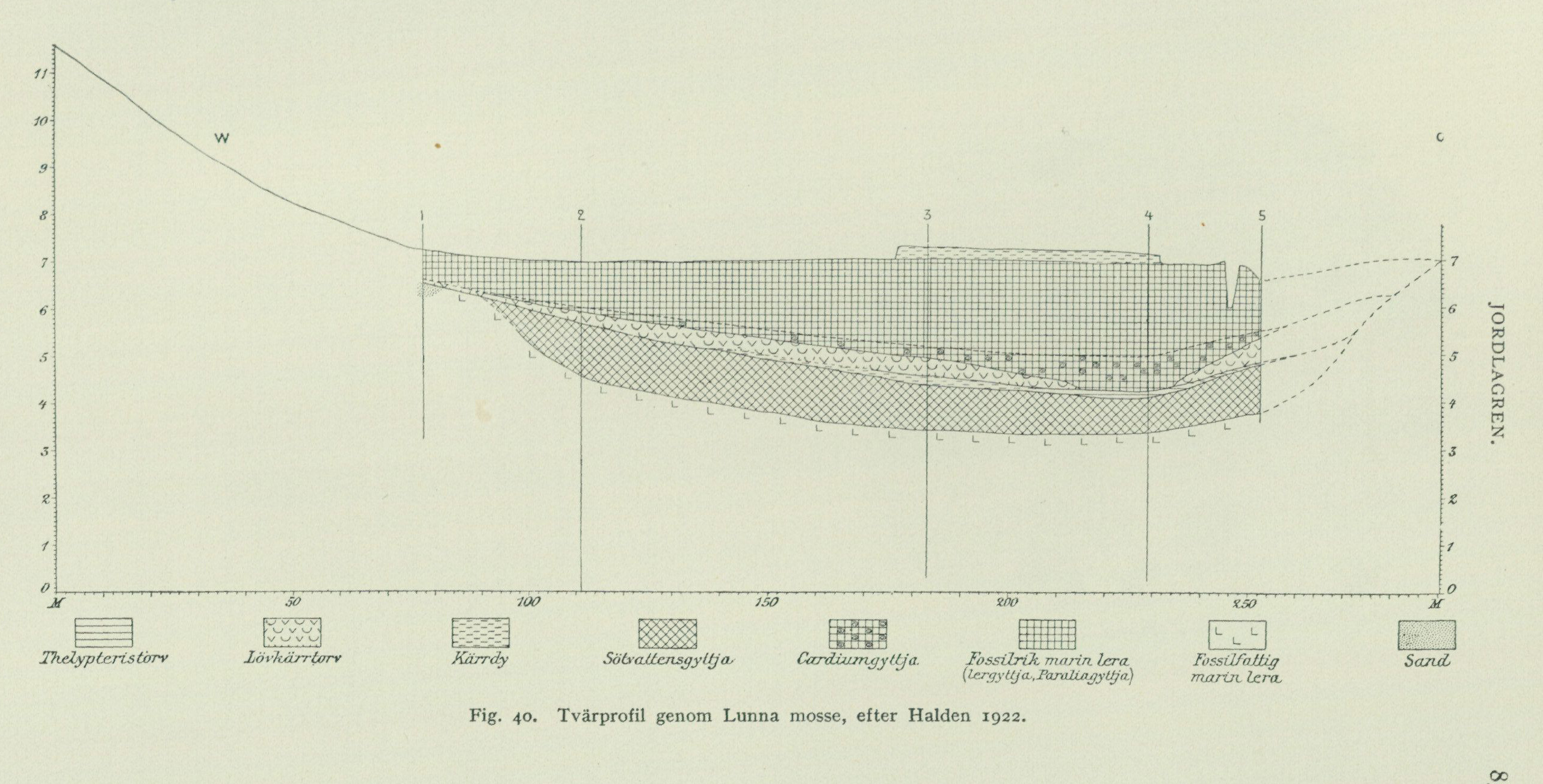
Figure 40 legend, left to right: Thelypteris peat; deciduous fen peat; fen mud; freshwater gyttja; Cardium gyttja; fossil-rich marine clay (clay gyttja, Paralia gyttja); fossil-poor marine clay; sand.
Fig. 40. Cross-section through Lunna mosse, after Halden 1922.
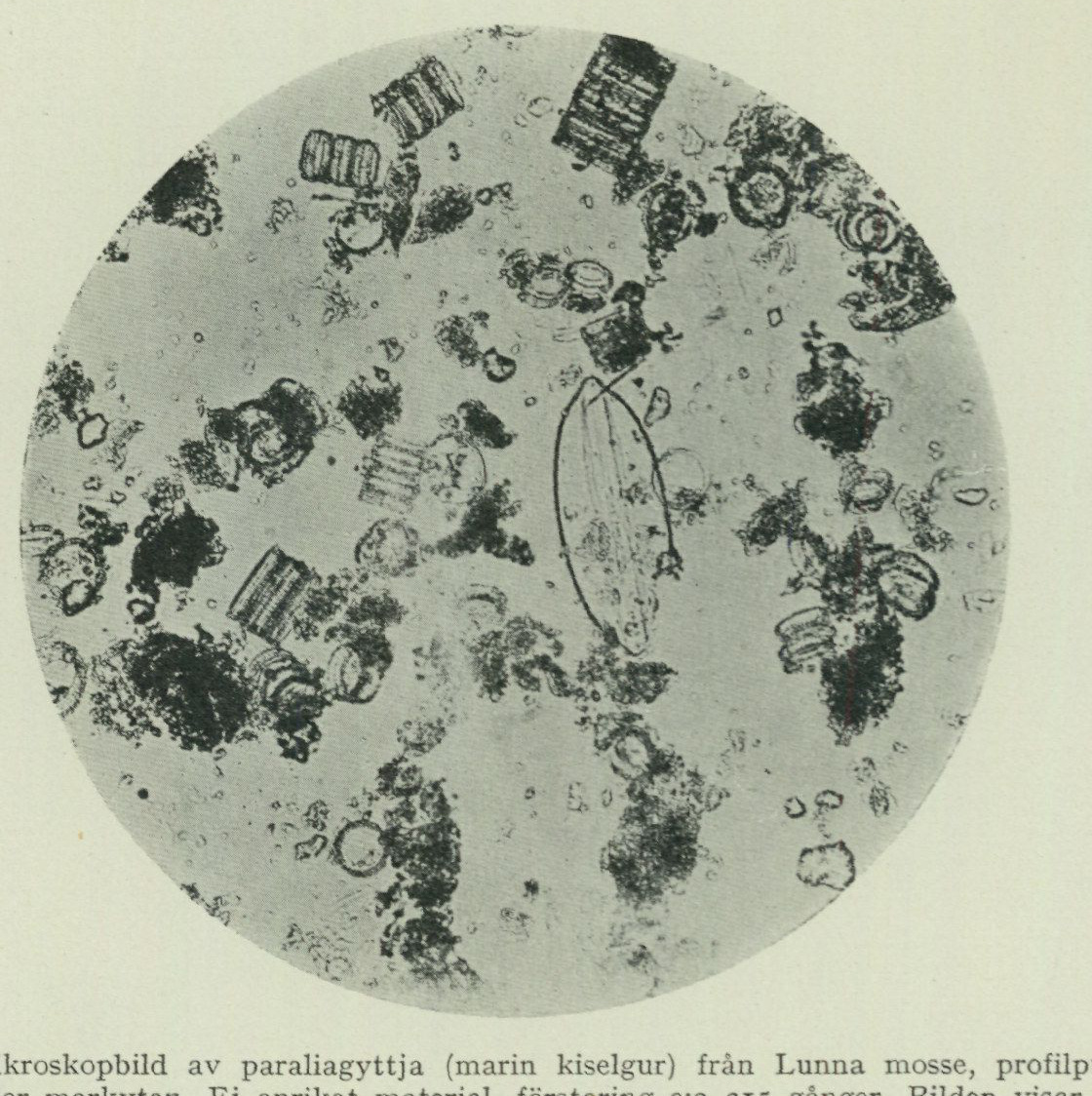
Fig. 41. Microscopic image of paraliagyttja (marine diatomite) from Lunna mosse, profile point 4, 145 cm below the ground surface. Unenriched material, magnification ca. 215 times. The image shows numerous, partly contiguous, specimens of Melosira (Paralia) sulcata in various positions and just to the right of the center an individual of Navicula lyra. B. Halden photo.
is in its lowermost part very poor in diatoms. Higher up occur such species as Biddulphia aurita, Navicula digitoradiata, N. distans and Trachyneis aspera. In the uppermost part of the clay pollen of Pinus and Betula are encountered sparsely. The diatom flora is there dominated by Melosira sulcata; among other species Amphitetras antediluviana, Diploneis Smithii v. borealis Grun. and Nitzschia punctata may be mentioned. In the boundary zone towards overlying gyttja have inter alia been found Najas marina, Nymphaea alba, Ruppia maritima as well as both salt water, brackish-water and freshwater diatoms. Freshwater gyttja. This consists for the most part of yellow-green plankton gyttja with freshwater diatoms. In the lower part there is a layer of calcareous gyttja with freshwater molluscs such as Limnaea ovata Drap., L. peregra Mull., Planorbis complanatus L., P. crista L., P. riparius Westerl., Sphaerium corneum L., Valvata cristata Miill., V. piscinalis Miill. The uppermost part is green-brown detritus gyttja with fruits of Lycopus europens and Potamogeton. Peat. At profile point 4 fen peat was encountered with Polystichum thelypteris and Lycopus europeus. The peat layer is here only 20 cm thick, but increases in thickness both W and E and consists there at the base of a thin layer of fen dy, which upwards passes into leaf fen peat. In the peat have inter alia been found aspen, birch, oak as well as several species of Salix, Ceratophyllum demersum, Najas marina, Potamogeton crispus, Scirpus lacustris etc.
Cardiumgyttja. This is a pyrite-nodule-blackened, mud-mixed clay gyttja with shells of Cardium edule and Mytilus edulis, fruits of Ruppia maritima, and sparse marine diatoms.
Paraliagyttja. The Cardiumgyttja grades upward into a brownish-grey, mealy when dry, diatomite, which due to the therein dominant diatom species, Melosira (Paralia) sulcata, has been called Paraliagyttja. Furthermore, it contains a number of purely marine diatoms, such as Caloneis blanda, Mastogloia angulata and Navicula lyra, see fig. 41.
Flood clay. The Paraliagyttja grades upward into a thin layer, not specifically indicated on the profile in fig. 40, which Halden designated as flood clay (svämlera). This is a fine-grained, grey-brown sediment, which in moist condition shows glossy cut surfaces, but after drying becomes hard and firm. The diatom flora is dominated by Diploneis interrupta, but also contains other marine species such as Melosira sulcata along with brackish-water species such as Campylodiscus echeneis and Navicula peregrina, as well as freshwater species such as Cymbella Ehrenbergi and Pinnularia species.
Peat. This is a well-humified fen peat of not more closely determined type, which inter alia contains seeds of Menyanthes trifoliata.
Fig. 42 shows a pollen diagram from profile point 4 and fig. 43 a diatom diagram, both taken from Halden’s work. Fig. 44 is a pollen diagram prepared by Thomasson, based on a denser sample series, collected immediately N of the road leading across the bog, thus from a more northerly point than Halden’s. Here the thelypteris peat layer between the freshwater gyttja and the Cardiumgyttja is absent. The “flood clay” was replaced by clay soil and the uppermost peat layer with Picea and Fagus is entirely absent. There is, as can be seen, very good agreement in the overall curve trends within both diagrams, although fig. 44, due to the sample density, provides richer details, especially regarding the two lowermost layers. Here approximate calendar years have been inserted in the right margin guided by the pollen-analytical datings that could be obtained inter alia from the Göteborg area and Västergötland. Note the beginning of the alder curve ca. 6 350 B.C. and the beginning of the lime curve ca. 4 500 B.C. The former belongs to the Ancylus period, the latter to the maximum of the postglacial marine transgression, the Litorina Tapes stage.
The developmental history was as follows: At the melting away of the ice from the area, the land was depressed below sea level, so that the contemporaneous shoreline, the highest marine limit (MG), at Fjärås lay at 77 m and at Göteborg 95 m above the present sea level. During this stage the lower marine clay was deposited. Already before the beginning of the Ancylus period, however, the shoreline as a consequence of land uplift had shifted down to a level which at Lunna lies somewhat lower1 than 12 m and at Göteborg 15 m above the present sea level. Through this the Lunna mosse basin was isolated from the sea, after which the freshwater gyttja and the thin peat layer resting upon it were formed. Due to the melting of the great land ice sheets, sea level began to rise, and during the Ancylus period the sea broke anew into the
1 A boring through the sediments in the valley immediately W of Kållereds railway station on the map sheet Särö, where the ground surface lies 9.6 m a.s.l., shows marine deposits throughout, even at the time of the formation of the freshwater gyttja in Lunna mosse. The regression therefore at Lunna probably did not reach far below the 12-metre level (according to the author’s calc., at most a metre or so).
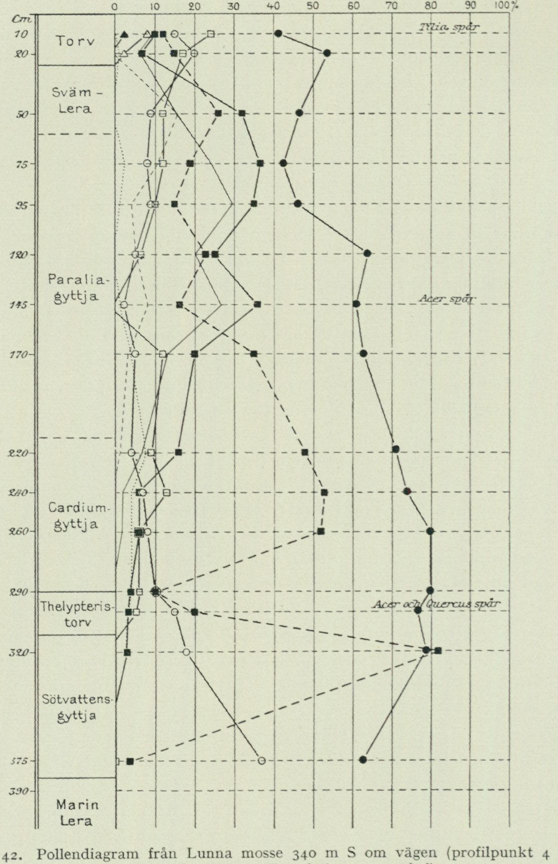
Lunna mosse basin. The rise of sea level continued during the earlier part of the Litorina period and reached its maximum when the lower part of the paraliagyttja in Lunna mosse was deposited, which is evident from fig. 43. This level is characterized in the pollen diagrams by the beginning of the continuous lime curve.1 The shoreline then lay at Onsala 19 m and at Göteborg 25 m above the present sea level. By this time the land ice sheets had melted away, and the still-continuing land uplift
1 This relationship has previously been established inter alia at Kungsladugård and Änggården within the map sheet Göteborg, S. G. U. Ser. Aa. No. 173, pp. 93—97.
[Source image: Fig. 42. Pollen diagram from Lunna mosse]
Fig. 42. Pollen diagram from Lunna mosse 340 m S of the road (profile point 4 in fig. 40) after Halden 1922. Symbols as in fig. 35.
Layer labels in profile (top to bottom): Torv (Peat) — Svämlera (Flood clay) — Paraliagyttja — Cardiumgyttja — Thelypteristorv (Thelypteris peat) — Sötvattensgyttja (Freshwater gyttja)
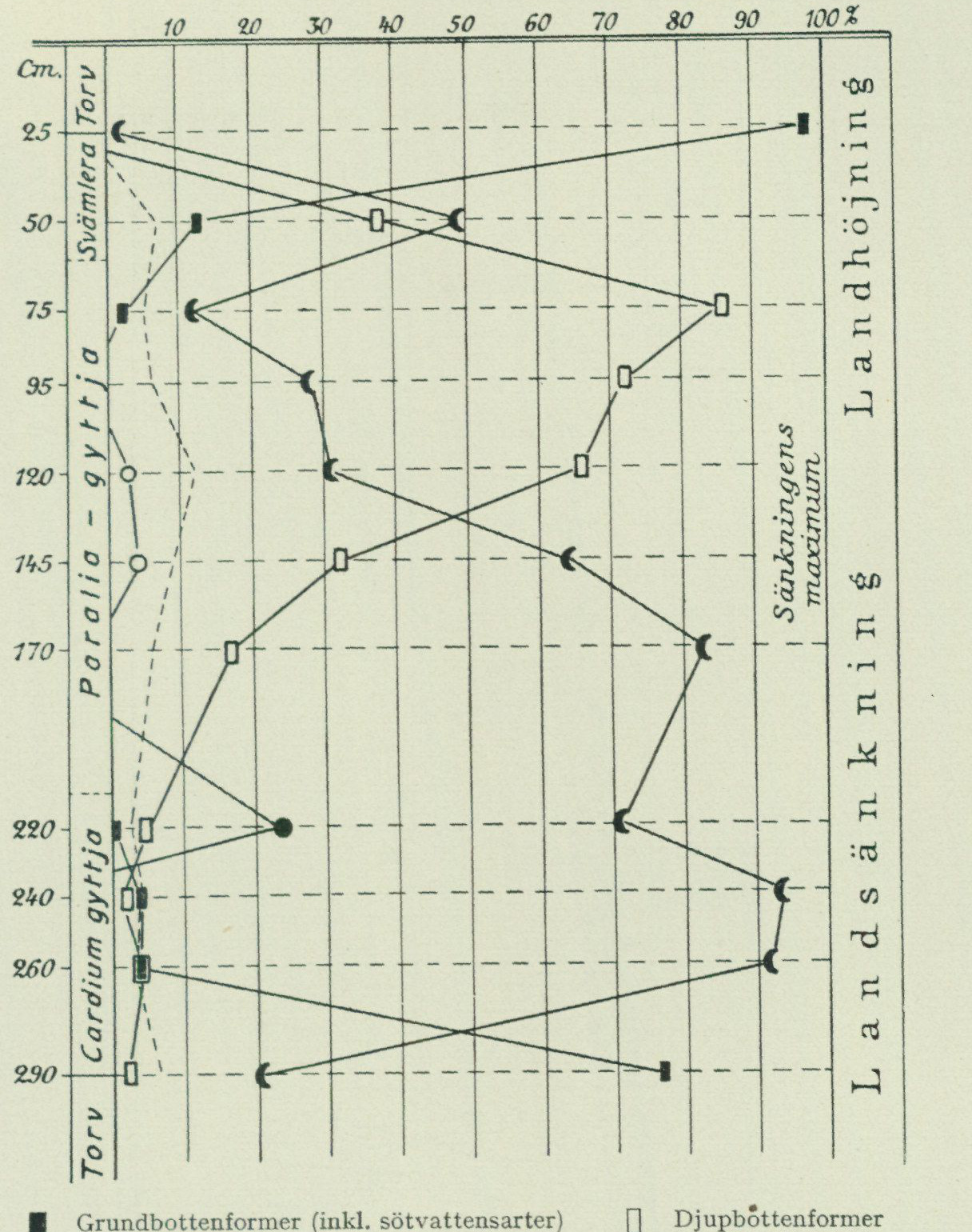
could again assert itself. When the shoreline in this process had shifted down to the 12-metre level, the Lunna mosse basin was isolated for the second time from the sea and the uppermost, now cultivated-away peat layer was formed.
Intermarine peat at Lunna
During the geological reconnaissance in 1948, O. Claesson noted that the postglacial marine clay within the cultivated fields between Lunna and Lunnaled, NW of Lunna mosse, is underlain by peat. A later boring, carried out the same year by both of us together, immediately S of the point E of Lunnaled,
[Source image: Fig. 43. Biological-bathymetric diatom diagram from Lunna mosse]
Fig. 43. Biological-bathymetric diatom diagram from Lunna mosse (profile point 4 in fig. 40) after Halden 1922. According to modern interpretation, the words “Land subsidence” should be replaced by “Transgression”, “Maximum of subsidence” by “Maximum of transgression” and “Land uplift” by “Regression”. Note how the curve for shallow-bottom forms (incl. freshwater species) shows that these are absent during the maximum of the transgression and that oceanic plankton appears there instead.
Legend:
| Symbol | Meaning |
|---|---|
| Solid line | Shallow-bottom forms (incl. freshwater species) |
| Dashed line | Deep-bottom forms |
| ◆ | Epiphytic forms |
| ◇ | Ditto, deep-water forms |
| • | Coastal plankton |
| ○ | Oceanic plankton |
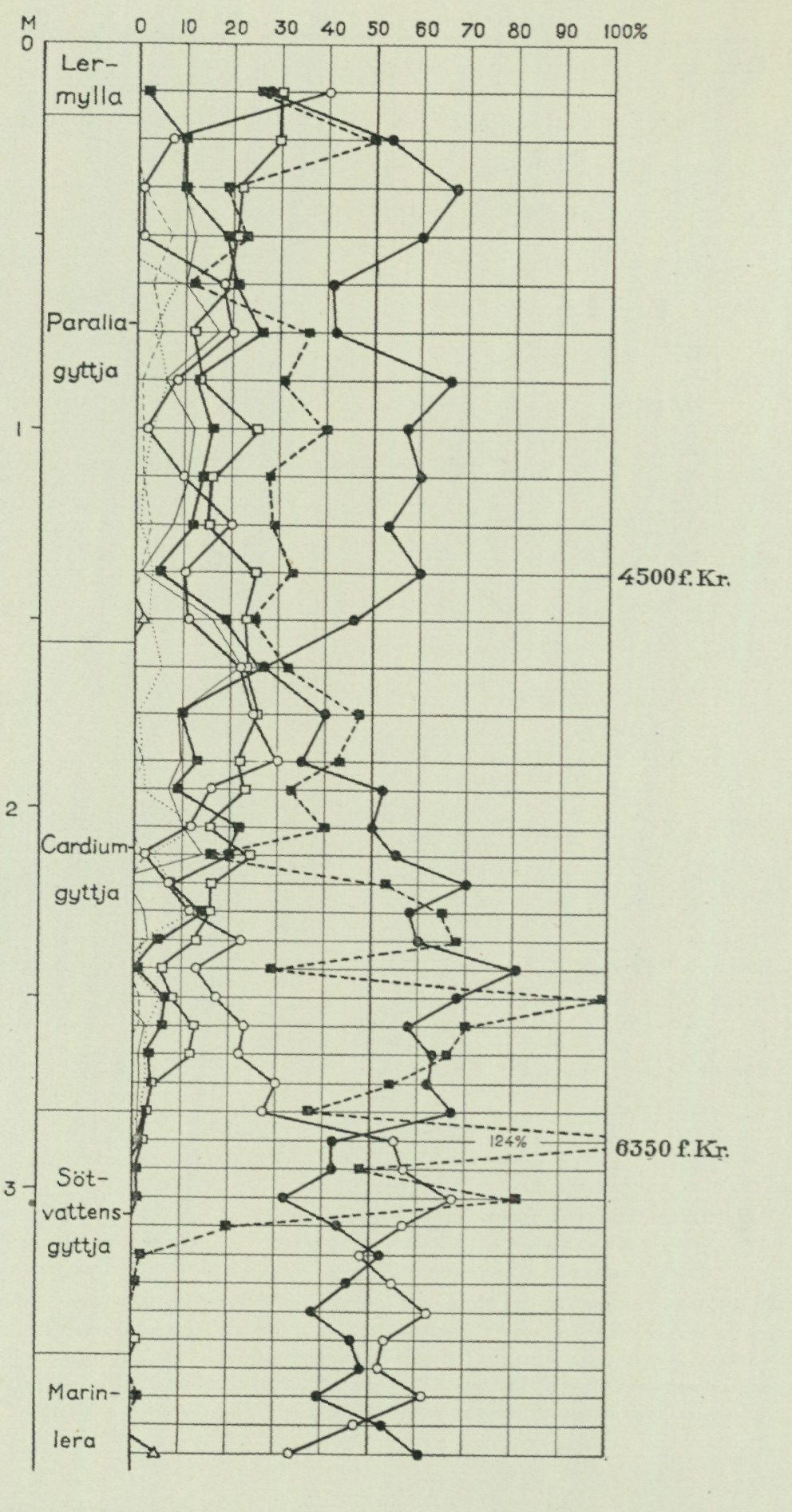
                                                  10  20  30  40  50  60  70  80  90  100%
                 Clay-

                      Paralia gyttja

                                                       4500 BC

                    Cardium-

                    Fresh-
                       water-
                       gyttja

                    Marine-
                        clay ^

 Fig. 44. Pollen diagram from Lunna mosse immediately N of the road. After Thomasson 1934.
Symbols as in fig. 35. The oak mixed forest curve, not plotted in the original diagram,
            has been inserted here to facilitate comparison with fig. 42.
where a ditch coming from the SW and one coming from the SE meet, the stratigraphy shown in fig. 45 is exposed. According to levelling by mirror, the borehole point lies at the elevation 23, S of Lunnaled, 12 m above sea level, thus at the same level as Lunna mosse. The boring was carried down to a depth of 8 m below the ground surface in marine clay without
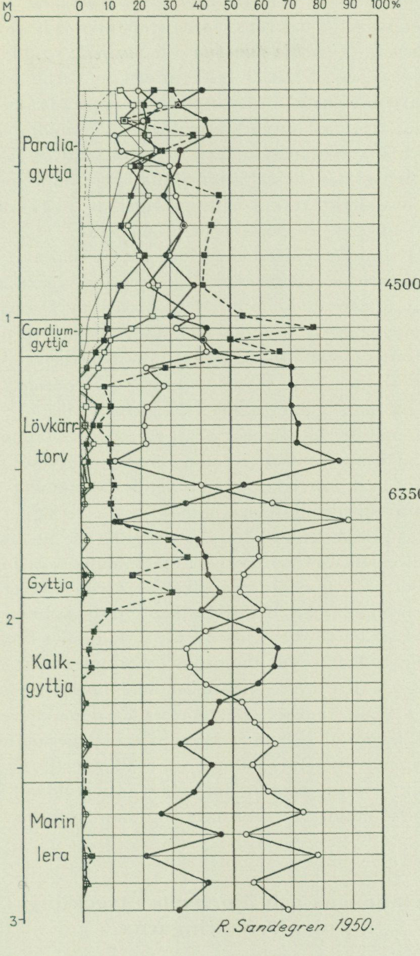
                                    10   20   30  40  50  60  70  80   90  100%

                Paralia gyttja

                                                     4500 BC

                  Cardium-

                  Leaf-fen-
                 peat

                                                   6350 BC

   Fig. 45. Pollen diagram from boring E of Lunnaled, Vallda parish. Symbols
                           as in fig. 35.
its substrate being reached. The clay in question is blue-grey from 3.5 m depth and downwards, and between 6 and 8 m depth shows a faintly developed varvation. It is practically free of microfossils. From 3 m depth and upwards the clay is grey and is characterised in its lower part by a purely marine diatom flora, entirely
dominated by Melosira sulcata and Amphitetras antediluviana. In the upper part these species decrease strongly in frequency, while epiphytes and such species as Campylodiscus echeneis, Nitzschia punctata and Surirella striatula, which indicate shallower water, make their appearance. In the uppermost sample of the clay, shallow-water species dominate, and in addition a few freshwater species appear. The marine clay is overlain by calcareous gyttja with freshwater molluscs,¹ desmidiaceans, Pediastrum species and solely such diatoms as live in fresh water. The thin layer of non-calcareous freshwater gyttja hosts the same diatom flora as the calcareous gyttja. On the gyttja follows a layer just over 70 cm thick of dark brown leaf-fen peat. This is finally overlain by postglacial marine clay.
The postglacial clay is black at the base and rich in shells of Cardium. The diatom flora is composed predominantly of epiphytes, such as Diploneis interrupta and several others, while Melosira sulcata is relatively sparse. This part undoubtedly corresponds to the Cardium gyttja of Lunna mosse. The uppermost metre is a light grey-brown to grey silty clay, whose diatom flora is dominated by Melosira sulcata and, at the level 25—50 cm below the surface, additionally by Navicula lyra. Its correspondence to the paralia gyttja of Lunna mosse is thus clear.
From the pollen diagram fig. 45, the good agreement is evident that prevails in the curve course at Lunnaled and in Lunna mosse, and which makes the correlation of the various layers fully clear, even in detail. Of special interest is that the “great boreal hazel maximum” of the Ancylus period, which in the older, sparser diagrams from the Gothenburg area appears as unified (see fig. 35, 41, 43 and 44 in the description of the map sheet Göteborg), in the diagram from Lunnaled is clearly divided into two distinct hazel maxima, of which the first occurs before the beginning of the continuous alder curve, the second when the transgression reaches the 12-metre level at Lunna. The relationship can also be seen in the diagram from Lunna mosse, but appears even more clearly at Lunnaled due to the fact that the intramarine layers there attain a considerably greater thickness than in Lunna mosse (142 cm at Lunnaled, 64 cm in Lunna mosse). The division of the boreal hazel maximum into two separate peaks also appears in diagrams from stratigraphic sequences within the Särö map sheet. These key levels, whose chronological position in relation to the course of the shoreline displacement in the Lunna area has been stated above, should prove valuable in continued investigations concerning the shoreline displacement problems on the Swedish west coast.
Development of climate, vegetation, and animal life in relation to the shoreline displacements.
Table VIII aims to provide an overview of subdivisions of the Late Quaternary made from various viewpoints, and of the relationships of the various divisions to each other, to the archaeological periods, and to the historical chronology; cf. also the pollen diagrams, fig. 34, 35, 39, 42, 44 and 45, and the shoreline-displacement curve, fig. 46.
¹ Limnaea ovata Drap., L. peregra Müll., L. stagnalis L., Planorbis nautileus L., P. umbilicatus Müll., Valvata cristata Müll. and V. macrostoma Steenb., according to determination by R. Hägg.
This curve is intended to illustrate the probable changes in the position of the shoreline in the Onsala area during different stages, from the time when the area was freed from ice and the highest marine limit was formed, up to the present day. In constructing it, consideration has been taken not only of the author’s own investigations but also of works carried out by other researchers, primarily J. Alin and H. Thomasson.
When the land ice melted away from the area, it was covered to the greatest extent by the sea, from which only the highest peak of Hylteråsen protruded as an island (fig. 32). This sea was an ice sea, in which pieces broken loose from the ice edge retreating towards NE drifted about as icebergs. Animal life in the sea had an arctic character, which is evident from finds of such species as the arctic mussel (Portlandia arctica) and polar bear, the latter admittedly not found within the Onsala sheet, but in ice sea clay at Göteborg. To the then existing land areas an arctic tundra flora migrated, characterised by mountain avens (Dryas octopetala), dwarf birch (Betula nana) and some willows (Salix). The nearest locality to the Onsala area where fossil remains of such flora have been found is a bog SW of Kållereds church within the Särö sheet. On the tundra lived, among others, the reindeer, as evidenced by several finds in surrounding areas.
The land uplift was, however, rapid. As the ice retreated further and further, the climate ameliorated. In the marine fauna, boreal species appeared, such as the large-sized cirripede Balanus hameri, and the land gradually began to be clothed with forest, mainly consisting of birch and pine. The finds in the lower parts of the beach gravel at Gottskär demonstrate that a Stone Age people with a primitive fisher and hunter culture migrated already during this early stage, before the late-glacial regression was completed.
During boreal time the alder migrated, and moreover the first traces of the noble hardwood trees elm and oak appear in the pollen diagrams. The beginning of the alder curve is considered to belong to the period around 6350 BC. The boreal period is furthermore characterised by abundant occurrence of hazel, which at that time is considered even to have formed closed forests. The occurrence of hazel forests, and consequently also the climate type that conditioned them, appears to have been limited to southwestern Sweden, for in the central and eastern parts of the country there prevailed simultaneously (during boreal time) a climate that was not only warm but in certain areas also extremely dry. The postglacial warmth-demanding marine fauna, characterised among other things by the oyster, also migrated during boreal time, when the postglacial transgression set in, as evidenced by the finds in the gravel immediately above the lower shingle layer at Gottskär.
During Atlantic time the favourable climate of the postglacial warm period reached its culmination. At the maximum of the postglacial transgression around 4500 BC the lime migrated. Oak mixed forests gave character to the landscape. The climate was warm and humid. In the settlement sites of the kitchen midden period, which are situated in close connection to the PG, antlers of red deer have been found.
The climate of the Sub-boreal period differed from that of the Atlantic period by a more continental character. The summers were probably relatively dry and warm, while the winters were likely colder than during Atlantic time.
According to the more complete pollen diagrams available from the map sheet Särö
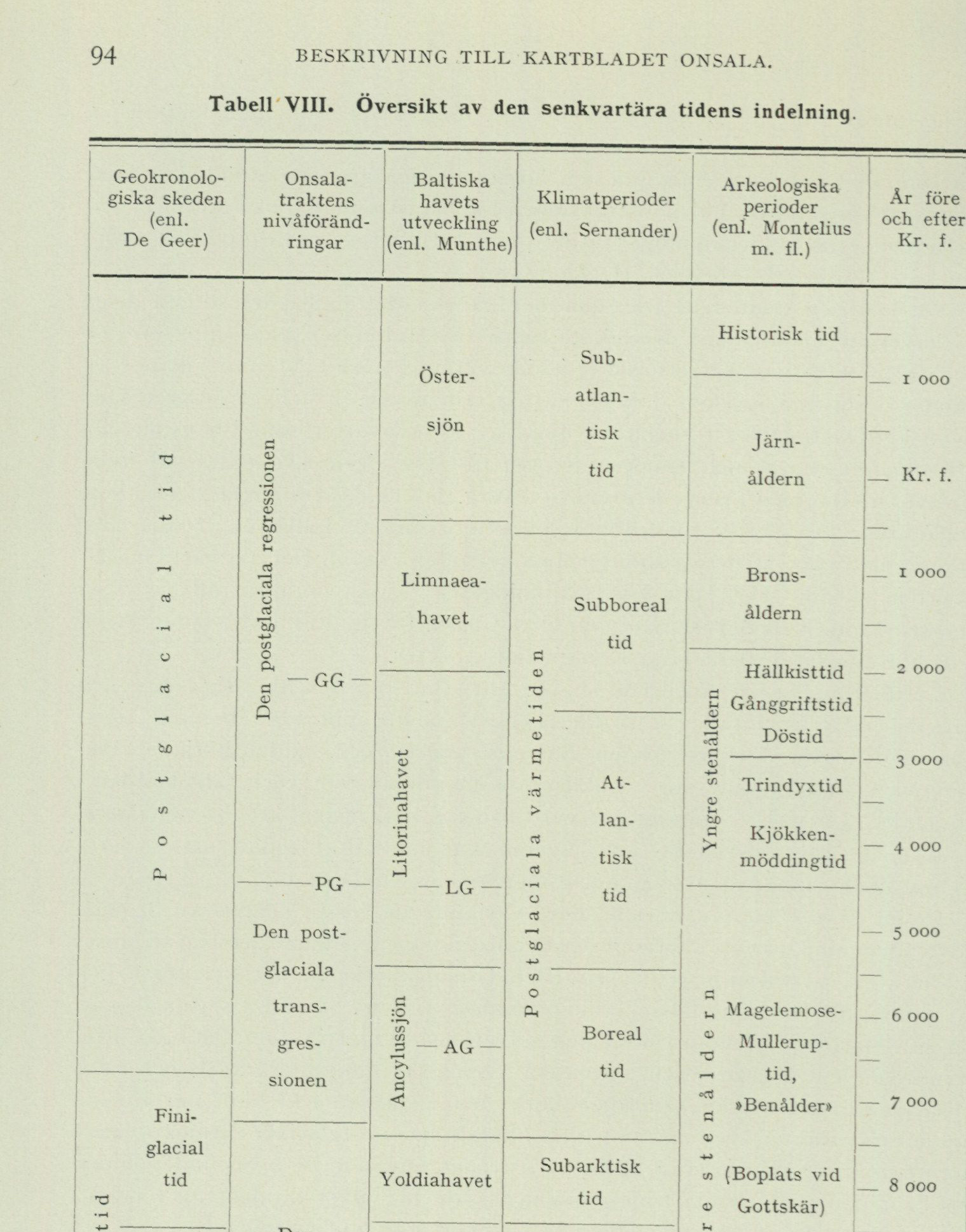
Table VIII. Overview of the subdivision of Late Quaternary time
| Geochronological stages (after De Geer) | Shore-level changes in the Onsala district | Development of the Baltic Sea (after Munthe) | Climatic periods (after Sernander) | Archaeological periods (after Montelius et al.) | Years before/after the birth of Christ |
|---|---|---|---|---|---|
| Postglacial time | Postglacial regression; GG | Baltic Sea / Limnaea Sea | Subatlantic | Historical time; Iron Age | present–birth of Christ and earlier |
| Postglacial time | Postglacial regression | Limnaea Sea | Subboreal | Bronze Age; stone-cist period; passage-grave period; dolmen period | c. 1,000–3,000 BC |
| Postglacial time | Postglacial regression; PG | Litorina Sea; LG | Atlantic | Funnel-beaker period; Ertebølle (kitchen-midden) period | c. 3,000–5,000 BC |
| Postglacial time | Postglacial transgression; AG | Ancylus Lake | Boreal | Maglemose–Mullerup period (“Bone Age”) | c. 5,000–7,000 BC |
| Finiglacial time | End of the postglacial transgression / beginning of the late-glacial regression | Yoldia Sea | Subarctic | Older Stone Age (settlement at Gottskär) | c. 7,000–9,000 BC |
| Gotiglacial time | Late-glacial regression | Baltic Ice Lake | Arctic | — | c. 9,000–10,000 BC |
The source is a chronological alignment diagram. Its printed abbreviations are GG, PG, LG, and AG; the horizontal rules indicate approximate correlations rather than exact synchronous boundaries.
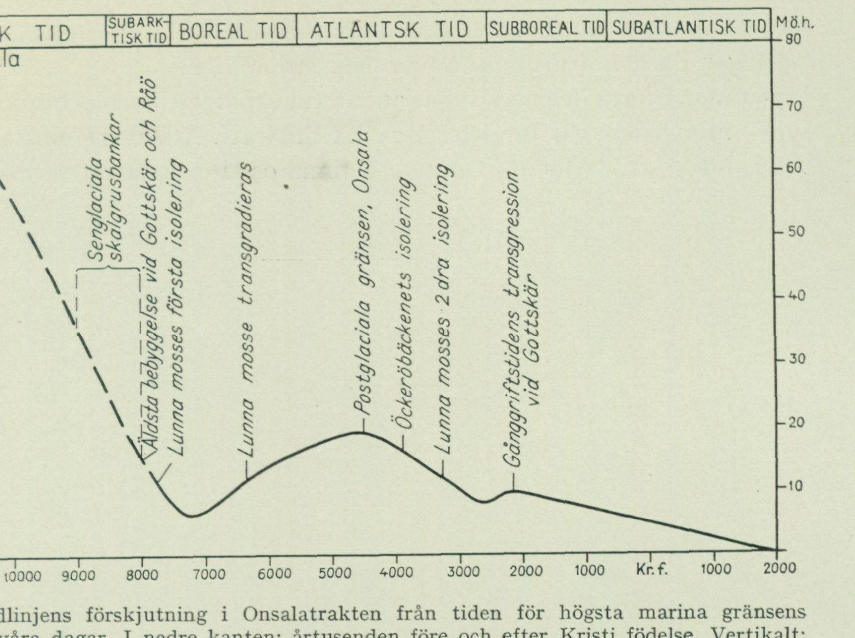
Fig. 46. Shoreline displacement in the Onsala district from formation of the highest marine limit to the present. Bottom margin: millennia before and after the birth of Christ. Vertical axis: height in metres above present sea level. Top margin: Arctic, Subarctic, Boreal, Atlantic, Subboreal, and Subatlantic climatic periods. The graph also marks the principal evidence used to construct the curve; see Table VIII.
and other parts of northern Halland, beech and hornbeam appear to have begun to appear in the district during the latest part of the period.
The Subatlantic period began with the remarkable climatic deterioration called the postglacial climatic deterioration, which set in around 600 BC. The temperature became lower and the precipitation more abundant than during the warm period. The climatic deterioration brought about a retreat of warmth-demanding animal and plant species. The pollen diagrams of the district indicate a certain frequency decrease for the mixed oak forest. This decrease is clearly pronounced in the case of elm and linden, whereas the frequency of oak, at least in the Onsala district, appears to have remained fairly constant. Regarding the relationship between the three noble tree species included in the mixed oak forest, it may moreover be mentioned that the newly elaborated diagrams for these areas show the same general tendency previously established for other parts of southern Sweden, namely that first elm (in Boreal time), then linden (in Atlantic time), and lastly oak (in Subboreal time) reach their highest pollen frequencies. The Onsala district shows, as mentioned, a strikingly high oak pollen frequency also in Subatlantic time (see fig. 34). The pollen diagrams from these areas moreover show a low but fairly even frequency of beech and hornbeam throughout the entire Subatlantic period. During the latest part of this period (from around 300 AD) spruce finally also appears. The present-day occurrence of spruce forest within the area is, however, as hinted above, the result of reforestation in more recent times.
The climatic deterioration is also manifested in the marine mollusc fauna, in that a number of Lusitanian species, such as Tapes decussatus, which have been found in shell-gravel banks from the warm period, no longer live along these coasts. One species that immigrated only during historical time is the soft-shell clam, Mya arenaria. It now occurs very commonly
along the shores, but fossils have never been encountered in deposits at a higher level than the present shoreline. The pronounced cold and humid climate during the former part of the Subatlantic period appears to have become increasingly mild toward our time. Several circumstances indicate that we are currently in a relatively dry climatic period.
Ancient monuments.
The ancient monument records compiled during the geological reconnaissance have been reviewed and supplemented by the Ancient Monuments Department of the National Heritage Board, which has provided the monument inventory below. In addition to the ancient monuments listed in this inventory, a number of Stone Age settlement sites are known within the Onsala sheet, including from the area around Gottskär, as well as from Runsås, Rydet, Råö and V. Hagen. All are likely to have been shore settlements. The artefact material found at the settlement sites indicates occupation during both the Older Stone Age and during the Neolithic, passage-grave period and stone-cist period. Archaeological-geological investigations carried out at some settlement sites have provided valuable contributions to knowledge of the late-Quaternary shoreline displacements (see pp. 77—82 and the literature cited there).
Gothenburg inventory no. — Vallda parish 84—85 NW of Forsbäck in a narrow pass approximately 500 m W of the road Onsala—Kungsbacka, a judge’s ring of 7 stones, and two smaller, torn-out cairns. 32 On a rocky hillock at the northern sheet margin N of Lerkil, a cairn. 38—39 On the mountain (Brännåsen) NE of Lunnaled, two cairns. 64—70 On the moraine hillock NE of Lunna village, a burial ground with 7 mounds. 40 On the mountain (Brännåsen) W of Lunnaled, a cairn. 80 On the crest of the NW end of Hylteråsen next to a triangulation marker, a fairly large cairn, called »Hylte rös». 41—43 On the mountain (Brännåsen) W of Lunnaled, two cairns and a mound. On the W edge of the N part of Hylteråsen, a fairly large, much torn-up cairn, called 79 »Lilla rös». 36 On the crest of the N part of the mountain E of Ängås and immediately W of Store mosse, a judge’s ring of 7 standing stones. 90—92 On the point Kilanäset W of Lerkilen, three cairns. 71—73 500 m SSE of Lunna village and NE of Skräddaregården, three mounds. 89 On a hillock SW of Forsbäck, a hillfort. 50—53 On Lyngfjället E of Halla, four cairns. 121—122 On Rossåsen S of Ängås, one small and one fairly large cairn. On the NW cliff of the height area SW of Lunna and E of the road toward Gräppås, a 57 small cairn. 123—125 On Kvarnkullen W of Gärdet, a destroyed cairn with two stone cists, approximately 60 m ESE of the cairn, a circle of 8 rounded stones; and approximately [distance and direction pixel-illegible] of the stone circle, two standing stones. 93—96 On rocky hillocks near the shore W—WNW of Plomhult, four cairns. 97—98 On the crest of a rock ridge W—WSW of Plomhult, two cairns.
Gothenburg inventory no.
126 At the road toward Buera near Gärdet small school, four standing stones. Two stand on either side of the road. The stones are approximately 2 m high and are called »Pykstenarna». 128 On »Höge kulle» immediately S of Gärdet, a cairn, now largely stacked into a stone pillar. 132 On the crest of a rocky hillock NE of Gräppås, a cairn. 133 On the mountain W of Bunn next to the W side of the road Vallda—Onsala, a hillfort. 104 On the height Brearö W of the cottage Grunsen and S of Vinbärgsholmen, a fairly large cairn, now a seamark. 110 On Mossekullaberget on the so-called Stenbräckeliden about 20 standing stones. The position on the map is uncertain. 109 At the S side of the so-called Mossekullaberget on Lunna outland, two judge’s rings and a number of standing stones. Position as above. 76 On the rocky hillock Börsås approximately 500 m ESE of Bunn and 600 m E of the road toward Onsala, a hillfort. 118 On a rocky hillock, called Börsås, SW of Buera, a hillfort. 105—106 On the crest of the so-called Gategårdsberget, at the shore WSW of Buera, two cairns. 107—108 On the mountain S of Hästakärr and N of Valldahemmet, two cairns. 136 On the crest of the height W of Gräppås (Lilla Gräppås) a cairn. 119 On the crest of a rocky hillock N of Bäcken, a cairn. 114 On a small narrow field SW of Buera Västergården a 1.9 m high standing stone. The position on the map is uncertain. 112—113 On the crest of a rocky hillock along the shore N of Valldahemmet, a cairn. On the E side of the mountain a judge’s ring. 135 On the NW corner of the height ENE of Hultås, a cairn. 134 On the height immediately NE of Hultås, a small cairn. 115 On the crest of a rocky hillock immediately NW of Valldahemmet, a torn-up cairn. 116 ENE of Valldahemmet in the middle of the field and S of brook, a 2 m high standing stone.
Onsala parish
40 Immediately S of Prässe next to the E side of the road toward Kungsbacka, an originally very large, now almost entirely removed cairn called »Ekemästerrös». 37 On the crest of the mountain NE of Skällared, a small torn-out cairn. 5 On the crest of the mountain, at the boundary between Onsala and Vallda parishes and 200 m E of the shore ENE of Virkesholmarna, a cairn. 7 150 m S of the farm Köpstads Mark, a small mound. 25 S of Hultås and next to the boundary to Vallda, a burial ground. 24 S of Hultås on a rounded rock surface, a cairn. 34 On Pixasen NNE of Håkulla, a torn-up cairn. 46 Between Apelröd and Vickan, a burial ground with 7 small mounds. 8 On the crest of the height N of Västra Hagen, a large cairn. 27 On the crest of the highest height N of Buerås, a cairn. 35 In a valley E of Pixåsen and NE of Håkulla, a cairn. 47 48 On a moraine ridge between Apelröd and Staregården, a burial ground with 11 mounds and 1 judge’s ring. 9 On the crest of a rocky hillock next to the shore, called Halsen, and directly E of Södra Virkesholmen, a small cairn. 49 N of Staregården, on the same moraine ridge as no. 47—48, a burial ground with 16 mounds. 28 On the SW edge of the height area N of Buerås, a cairn. 29 On the crest of the S part of the height area N of Buerås, a cairn. 11 On the crest of the N point of Onsala Sandö, a small cairn.
Gothenburg inventory no. 13 On the E side of Onsala Sandö, on a rock hill in the middle of the island, an elongated cairn. 31 On the hill Gransås between Buerås and Köpstaden, an ancient hillfort. 22 On the so-called Gamlefjäll W of Rörvik, near the sound between Onsala Sandö and the main land, an ancient hillfort. 51 800 m WNW of Onsala church, N of the road Onsala church—Bränna, a burial ground with 12 small low mounds. 52—56 On »Klockehögen» NNW of Onsala church, a stone circle, a group of 5 stones set in a circle and four single standing stones. 23 On the crest of the hill Svänghalsen or Svingehallen, at the sound between Onsala Sandö and the mainland, a cairn. 15 On the highest point of the S end of Onsala Sandö, a cairn. 32 On a moraine hill WNW of Köpstaden, a small mound. 77—80 On the height NW of Ötofta, in the forest, four cairns. 88 On the crest of the hill at Bassås, a cairn, now in the form of a round stone pillar. 66 On the hill slope immediately N of Liden, a small mound. 82 On the crest of a rock hill NW of Ötofta, a torn-up cairn. 76 On the crest of the northernmost rock ridge on Fjärhals, a small cairn. 83 On the crest of the hill immediately W of Ötofta, a completely dug-out cairn. 87 On the crest of the hill WNW of Arvidsgården and SE of Ötofta, a cairn. 90 On the crest of the rock hill N of the northernmost Knapegården, a cairn. 91 On the highest point of Lindö, a fairly large, well-preserved cairn. 135 E of the road between Rösan and Prästäng, a mound. 137 On the hill S of Gottskär, a cairn, rebuilt into a customs lookout. 101 On the crest of the hill NW of Knaperyd, a cairn with a lookout hut. 103 At Knaperyd and NW of Häcklehagen, a burial ground with 13 mounds. 104 On the western part of the hill W of Häcklehagen, a cairn. 107 On the crest of the hill immediately SW of Knastås, a cairn. 151 In a valley depression in the middle of the W side of Ramnö, a well-preserved labyrinth. 109 On the crest of the so-called Urnefjäll SW of Knastås and N of Sönnerbergen, an almost destroyed cairn. 130 On the E side of the narrowest part of Skallanäs, a labyrinth. 111 Immediately N of Mönster and 200 m NE of the pilot lookout, a labyrinth. 110 On the hill with the pilot lookout at Mönster, a cairn. The pilot lookout has been erected on the cairn. 118 On the highest point of Malön, a large cairn.
Ölmevalla parish
31     On the highest point of the S part of Vindön, a small cairn.
33    On the island Inre Lön's highest point, a fairly large cairn.
32     On the N part of Yttre Lön, a labyrinth, called »Trelleborgs slott».
89—95 At Näskroken on the SW tip of Örmanäslandet, seven cairns, one of which lies on the map sheet boundary (at the sheet margin).
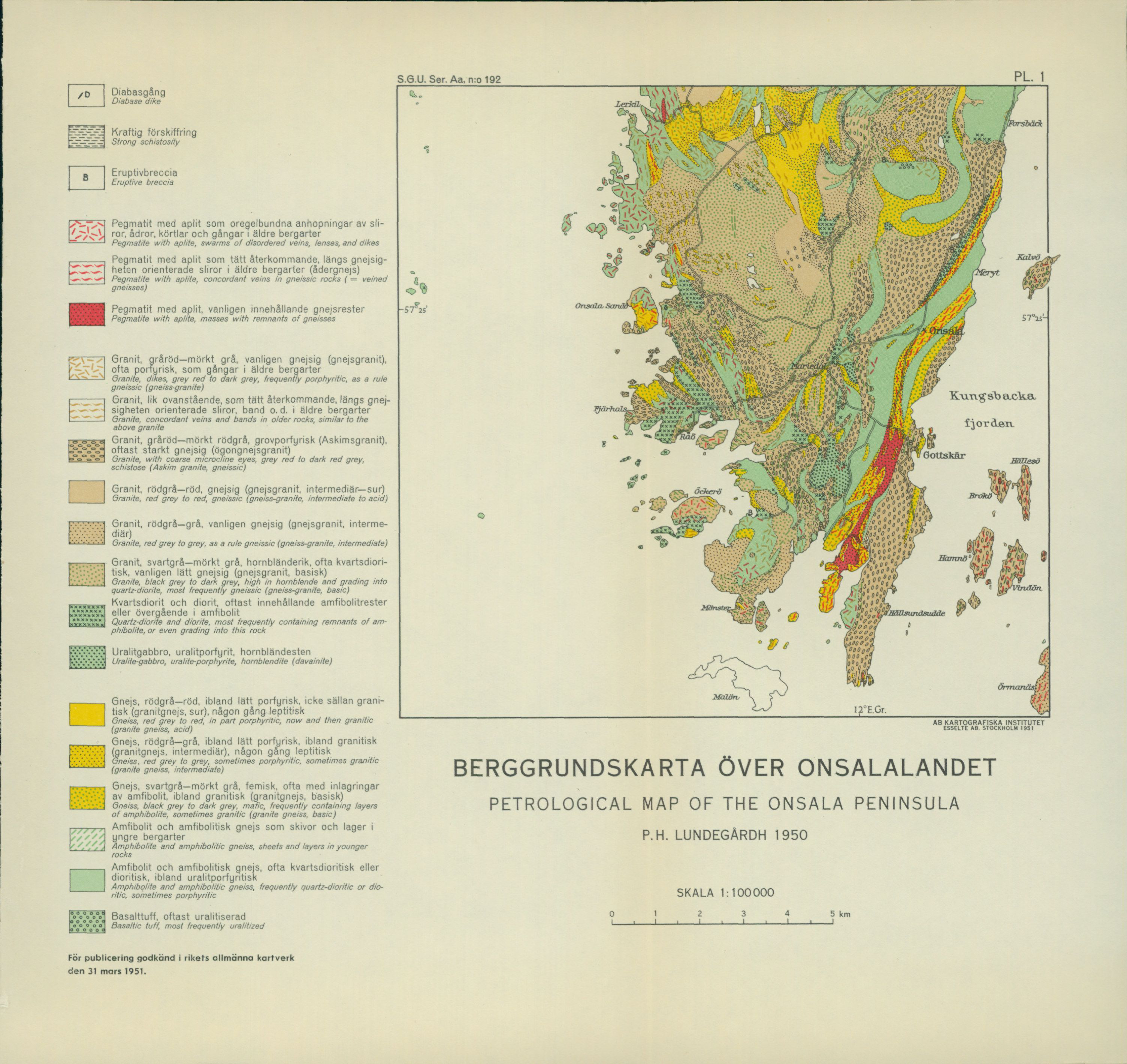
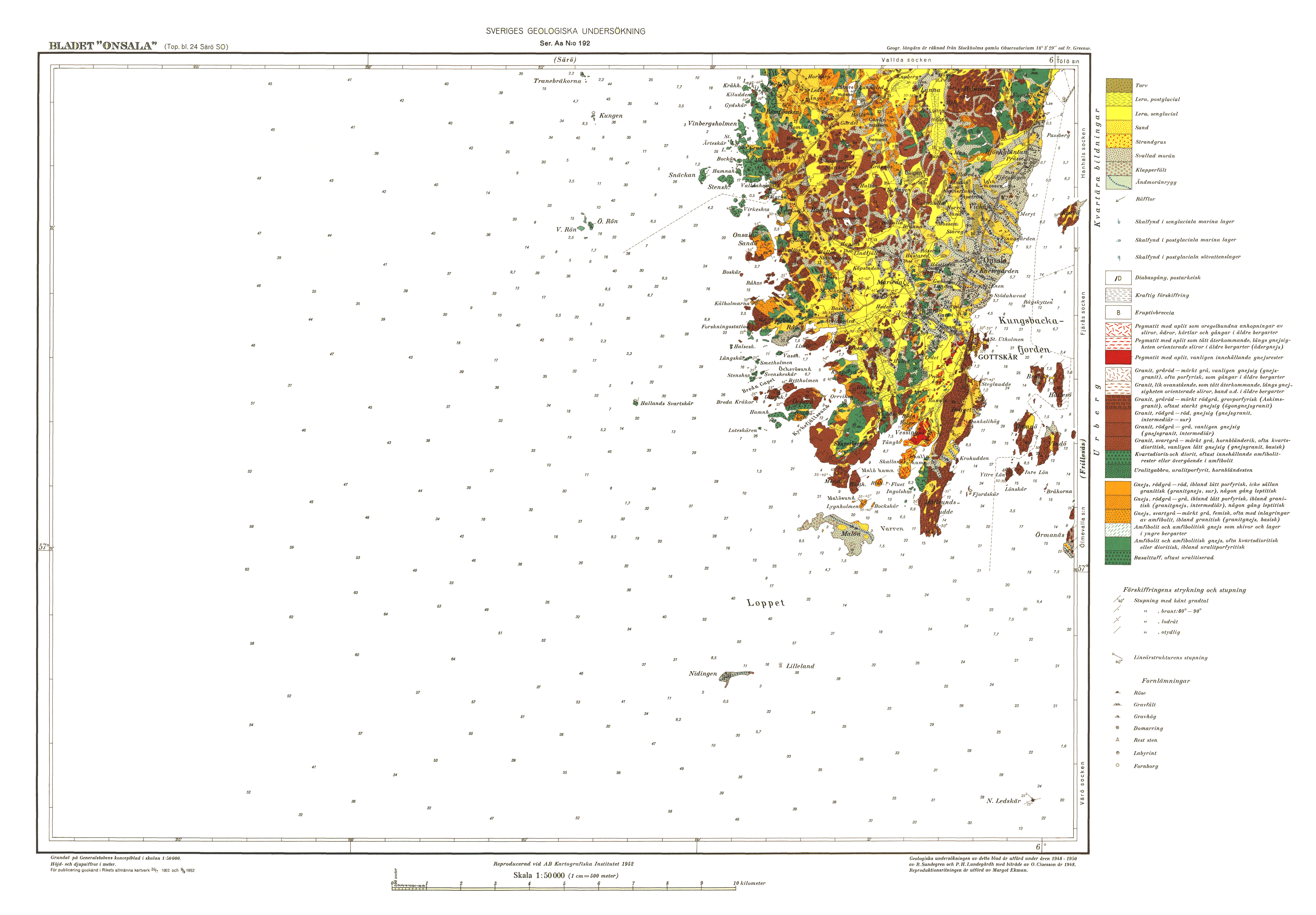
S.G.U. Ser. Aa. No. 192 — Pl. 1
BEDROCK MAP OF THE ONSALA PENINSULA P. H. LUNDEGÅRDH 1950 SCALE 1:100 000
Legend:
- Diabase dike
- Strong schistosity
- Eruptive breccia
- Pegmatite with aplite as irregular accumulations of streaks, veins, lenses, and dikes in older rocks
- Pegmatite with aplite as closely recurring, concordant streaks oriented along the gneissosity in older rocks (veined gneiss)
- Pegmatite with aplite, usually containing gneiss remnants
- Granite, grey-red—dark grey, usually gneissic (gneiss granite), often porphyritic, as dikes in older rocks
- Granite, similar to the above, as closely recurring, concordant streaks, bands, etc. oriented along the gneissosity in older rocks
- Granite, grey-red—dark red-grey, coarsely porphyritic (Askim granite), usually strongly gneissic (augen gneiss granite)
- Granite, red-grey—red, gneissic (gneiss granite, intermediate—acid)
- Granite, red-grey—grey, usually gneissic (gneiss granite, intermediate)
- Granite, black-grey—dark grey, hornblende-rich, often quartz-dioritic, usually slightly gneissic (gneiss granite, basic)
- Quartz-diorite and diorite, most often containing amphibolite remnants or passing into amphibolite
- Uralite gabbro, uralite porphyrite, hornblendite
- Gneiss, red-grey—red, sometimes slightly porphyritic, not infrequently granitic (granite gneiss, acid), occasionally leptitic
- Gneiss, red-grey—grey, sometimes slightly porphyritic, sometimes granitic (granite gneiss, intermediate), occasionally leptitic
- Gneiss, black-grey—dark grey, mafic, often with interbeddings of amphibolite, sometimes granitic (granite gneiss, basic)
- Amphibolite and amphibolitic gneiss as sheets and layers in younger rocks
- Amphibolite and amphibolitic gneiss, often quartz-dioritic or dioritic, sometimes uralite-porphyritic
- Basaltic tuff, most often uralitized
Approved for publication at the National Land Survey of Sweden on 31 March 1951.
[VISUAL PLATE: The entire map with place names, colours, patterns, and the spatial relationships of symbols preserved as source image. Place names shall not be translated.]
[SOURCE DEFECT: The affixed pocket on the inside of the back cover obscures parts of the SGU printed publication list. SGU metadata indicates that this applies to all copies. No hidden text has been reconstructed. The visible page is preserved as a source image.]
Yearbook 44 (1950)
No. 515 Grip, Erland, Geology of the sulphide deposits at Hensträsk and a com- parison with other deposits in the Skellefte district. With 4 plates. 1951 5.00 * 516 Ödman, Olof, Manganese mineralization in the Ultevis district, Jokkmokk, North Sweden. Part 2. Mineralogical notes. 1950 … 1.50 » 517 Asklund, Bror, Kosteröarna, a key area for the Pre-Cambrian geology of Western Sweden. Summary: The Koster isles, a key area for the Pre-Cambrian geology of Western Sweden. With 2 plates. 1950 . . 6.00 » 518 Arrhenius, O., The distribution of certain elements in the soil in Kopparberg county. Summary: Some minor elements of the soils in the province of Kopparberg (Dalecarlia). 1952 … 2.50 * 519 Wenner, C. G., Fjärås bräcka. 1951… 3.00
                        Yearbook 45 (1951)

  »  520 Sundius, N., Quartz, feldspar and mica and their occurrences in
            Sweden. 1952    ............................................................................................................   10.00
Ser. Ba. No. 13 Bedrock map of the Stockholm area compiled by N. Sundius. 1:50,000. 1946 …10.00 Description of the bedrock map of the Stockholm area by N. Sundius. 1948 …5.00 » 14 Quaternary deposit map of southern and central Sweden. Compiled from the geological map sheets at the SGU by K. E. Sahlström 1:400,000. Central sheet, printed 1947 … 15.00 Southern sheet, printed 1948 … 15.00 Northern sheet, printed 1949 … 15.00 Ser. Ca. No. 21 Lundqvist, G., Description of the Quaternary deposit map of Kopparberg county. With map at scale 1:250,000. 1951 … 20.00 » 35 Geijer, Per and Magnusson, N. H., The geology of the central Swedish iron ores. With 56 plates. 1944… 35.00 » 36 von Eckermann, H., The Alkaline district of Alnö Island (Alnö alkaline district). With 60 plates. 1948 … … 15.00
                Reports and communications in mimeographed form

        1. Investigation concerning the lime supply for Swedish agriculture 1—2. 1931
          (Maps out of print)..............................................................................................15.00
        2. Sweden's sounded lakes. Compiled by K. E. Sahlström 1945        .    .  3.00
    3  Report on manganese ore prospecting in Jokkmokk parish 1940—48
        by O. H. Ödman. With 4 maps............................................................4.00
Distributed through Generalstabens Litografiska Anstalt, Stockholm