Original publication
Original title: Beskrivning till kartbladet Göteborg
Author: Ragnar Sandegren and Harald Elias Johansson
Publication year: 1931
Original language: Swedish
Source file MD5:c83e48d72071b8206edf498cbbdd06ad
Ragnar Sandegren and Harald Elias Johansson
Original title: Beskrivning till kartbladet Göteborg
Series: Sveriges geologiska undersökning, Series Aa, No. 173
Original publication: Sveriges geologiska undersökning (Geological Survey of Sweden)
Language: English translation from Swedish
Source records: Description PDF · Related geological map sheet
SWEDEN’S GEOLOGICAL SURVEY
Ser. Aa. Map sheets at scale 1:50,000 with descriptions. No. 173
   DESCRIPTION

                         OF
MAP SHEET GÖTEBORG
                      BY

       R. SANDEGREN and H. E. JOHANSSON

           WITH ONE PLATE

         Price 4.00 kr.

               STOCKHOLM 1931

           ROYAL PRINTING HOUSE.   P. A. NORSTEDT & SÖNER
SWEDEN’S GEOLOGICAL SURVEY
Ser. Aa. Map sheets at scale 1:50,000 with descriptions. No. 173
   DESCRIPTION

                          OF
MAP SHEET GÖTEBORG
                       BY

       R. SANDEGREN and H. E. JOHANSSON

           WITH ONE PLATE

                STOCKHOLM 1931

            ROYAL PRINTING HOUSE.   P. A. NORSTEDT & SÖNER
The present map sheet, which covers the southern half of the sheet Göteborg (S. G. U. Ser. Ac. No. 4), published in 1902 at the scale 1:100,000 but now out of print in the book trade, is the result of a complete new reconnaissance of the area. In this work, the city of Göteborg and the area immediately surrounding it, together with Backa and Tuve as well as the greater parts of the parishes of Björlanda and Säve, were surveyed at the scale 1:20,000, the remainder at the scale 1:50,000. The map image is thus more detailed within the areas surveyed at the larger scale, for which the original maps were reduced during reproduction.
A smaller part of the area mapped at the larger scale has been published at the scale 1:25,000 in the work »Göteborgstraktens geologi», Göteborg 1923 and 1924, included in Göteborgs Jubileumspublikationer.
The chapter »The Bedrock», the writing of which was entrusted to the State Geologist H. E. Johansson, and of which, at his death in January 1931, only the first pages existed in manuscript, has otherwise been edited by R. Sandegren on the basis of the bedrock map completed by Johansson and of his surviving field notebooks together with oral instructions previously given, in essential agreement with the presentation Johansson himself had given in the 1924 offprint edition of »Göteborgstraktens geologi». The remaining chapters have been written by Sandegren.
CONTENTS
Introduction. Scope of the map sheet. Topographical conditions. Landslides. Watercourses and lakes. Vegetation, settlement and industries. Main features of the geological development of the area — 5
The bedrock — 18
- The gneiss bedrock — 18
- Petrographic character and subdivision of the gneiss formation — 18
- Geological structure of the gneiss formation — 24
- Mode of formation of the gneiss formation — 40
- Pegmatites — 42
- Older diabases — 43
- Younger diabases — 45
- Crush zones in the bedrock — 47
Quaternary deposits — 50
- Glacial formations — 50
- Glacial striae — 51
- Giant’s kettles — 52
- Till formations — 58
- Glaciofluvial deposits — 67
- Ice-marginal lines — 74
- Late-glacial marine formations — 76
- Postglacial formations — 92
- Marine formations — 97
- Supramarine deposits — 109
- Immigration sequence of the lower marine fauna — 126
- Development of climate and vegetation in relation to the shoreline displacement — 133
- Practical use of the soil types — 137
Sources — 138 Antiquities — 139
Introduction.
By R. Sandegren.
The geological map sheet Göteborg at a scale of 1:50,000 (661 sq. km), Scope of the corresponding to the southeastern quarter of the topographic sheet “Göteborg” map sheet. at a scale of 1:100,000, falls for the most part within Göteborgs and Bohus län, but also comprises in its northeastern part a smaller area belonging to Älvsborgs län. The following parishes and parts of parishes belong to the map-sheet area: within Göteborgs and Bohus län: the city of Göteborg and of Askims härad: the northern part of Fässbergs parish with part of Mölndals stad, the northern part of Västra Frölunda parish, Nya Varvets församling, and some islets and skerries belonging to Styrsö parish; of Sävedals härad: the greater part of Örgryte parish, now incorporated into the city of Göteborg, as well as the westernmost part of Partille parish; the whole of Östra Hisings härad, comprising Tuve and Lundby parishes, the latter now incorporated into the city of Göteborg; the whole of Västra Hisings härad, comprising Öckerö, Torslanda, Björlanda, Backa, Säve and Rödbo parishes; of Inlands Södre härad: the whole of Harestads, the greater part of Torsby, and smaller parts of Lycke and Ytterby parishes; moreover, of the area of Kungälvs stad, the town proper, although for the most part falling outside the map-sheet boundary, has been included; within Älvsborgs län: of Vätle härad: the western part of Angereds parish; of Ale härad: the southwestern part of Nödinge parish.
The map sheet thus encompasses the mouth area of the Göta älv. Its central Topographical conditions. part is occupied by the large island of Hisingen, which is enclosed by the two distributaries of the river and by the fjords into which it discharges its waters: Älvsborgsfjorden, which continues westward as Danafjord, and Älvefjorden. To the N, E and SE extends mainland, and to the W that part of the southernmost archipelago of Bohuslän which is called the “Göteborg northern archipelago” (Öckerö parish), while in the far northwestern corner the southernmost part of the “Marstrandsöarna” archipelago extends onto the sheet. The area exhibits a strongly broken terrain, where mostly bare rock plateaus alternate with deeply incised valley depressions occupied by unconsolidated deposits.
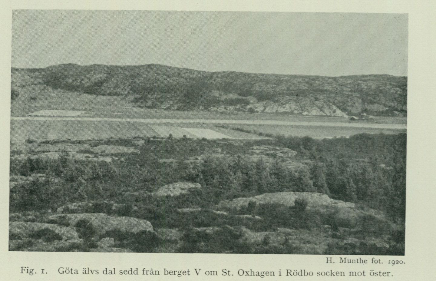
The highest measured points, located in the far east, reach more than 120 m above sea level. As examples may be mentioned the elevated area south of Skårdal in Nödinge parish, whose highest point is 128.9 m, and Gärdsås kulle in Partille parish 125.6 m. In the eastern parts of Hisingen and south of Göteborg, the plateaus generally reach somewhat more than 100 m above sea level. The highest points here are found south of Åsen in Rödbo parish, 118.4 m, and on Västerberget in Fässbergs parish, 118.8 m. The highest points farther west on Hisingen are Stora Vete, on the boundary between Lundby and Björlanda parishes, 93.2 m, and
H. Munthe, photograph, 1920. Fig. 1. The valley of Göta älv seen from the hill west of St. Oxhagen in Rödbo parish towards the east.
“Telegrafberget,” south of Noraskog in Björlanda parish, 65.8 m. In Torsby and Torslanda parishes the rock plateaus generally rise no higher than between 40 and 50 m above sea level, and on the larger archipelago islands to 20–30 m. The fjords are, apart from occasional channels or bowl-shaped depressions, for example between southwestern Hisingen and the islands Björkö, Kalvö and Grötö, very shallow (10–20 m), and only out in the open sea at the western map-sheet boundary are depths exceeding 30 m encountered. The part of the area that lies below sea level thus has, in all essentials, the same topographical character as the land area and evidently constitutes the direct continuation of a single large bedrock plateau sloping gently westward, which is dissected by a network of deep valleys and depressions. A number of these valleys particularly attract attention through their broadly rectilinear and mutually fairly parallel courses. These valleys are so-called rift valleys, which have been sculptured along major fracture and crush zones in the bedrock, originating from displacements in the earth’s crust that have occurred during different geological periods. From the map it is evident how the rift valleys, with regard to their orientation
be distributed into different groups or fracture systems. The most prominent valley directions are thus N to S, NE to SW and NW to SE.
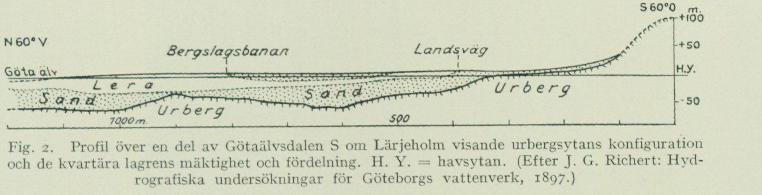
The most significant of the area’s N–S-trending valleys is the one occupied, from the northern sheet boundary to the mouth of Säveån, by Göta älv and S of this point by Mölndalsån. The valley’s width varies between a few hundred m and more than one km. The Quaternary valley fill reaches only insignificantly above sea level, while the valley sides, in slopes steeper or gentler, rise to, as mentioned above, about 100 m above sea level (Fig. 1). Borings in the loose soil layers of the valley bottoms have demonstrated that these are of great thickness. As appears from Fig. 2, solid bedrock in the valley bottom S of Lärjeholm is not encountered until 50—60 m below sea level, and at another location in the vicinity not until 90 m below the same. Judging from borings at the mouth of Säveån, the depth
N 60° W Railway Road Clay Crystalline bedrock Sand Crystalline bedrock Peat
Fig. 2. Profile across a part of Götaälvsdalen S of Lärjeholm showing the configuration of the bedrock surface and the thickness and distribution of the Quaternary deposits. H. Y. = sea level. (After J. G. Richert: Hydrographic investigations for the Göteborg waterworks, 1897.)
to solid bedrock here is probably even greater. The vertical distance from the highest parts of the bedrock plateau to the bedrock surface in the deepest parts of the valley trough thus seems sometimes to amount to nearly 200 m.
Another N–S-trending valley of importance is the one whose southern part is named Kvillebäcksdalen. It can be followed from the Nordre älv channel between Munkholmen and Hisingen straight toward S past Tuve to Göteborg. Fig. 3 shows the valley N of Grimbo in Tuve parish. Although Kvillebäcksdalen is narrower and less prominent in the terrain than Götaälvsdalen, solid bedrock bottom has nevertheless not been encountered, e.g. somewhat S of Aröd in Backa parish, until at a depth of 40 m below sea level.
Belonging to the N–S-trending valley system are further, apart from a large number of smaller valleys including in the area immediately around Göteborg, the two large valleys occupied by the sounds, one E of the islands Björkö, Kalvö and Grötö, the other W of the same islands, and which attain depths exceeding 30 m.
Among valleys with NE–SW direction may be noted in the first place the valley occupied by Säveån, the lowermost course of Göta älv and Älvsborgsfjorden, here for brevity called Säveådalen, as well as the Nordre älv valley.
Säveådalen has approximately the same dimensions as Götaälvsdalen. Especially on the northern side it is bounded in many places by steep rock walls such as at Utby, Ramberget (Keillers park) and Pölsebo, but the southern side also displays considerable heights such as at Olskrokens station, Masthuggskyrkan and Käringberget. Borings through the loose valley fill near the eastern sheet boundary have shown that solid bedrock here in places is not encountered until at more than 40 m depth below sea level, and at Masthuggskajen in the direction
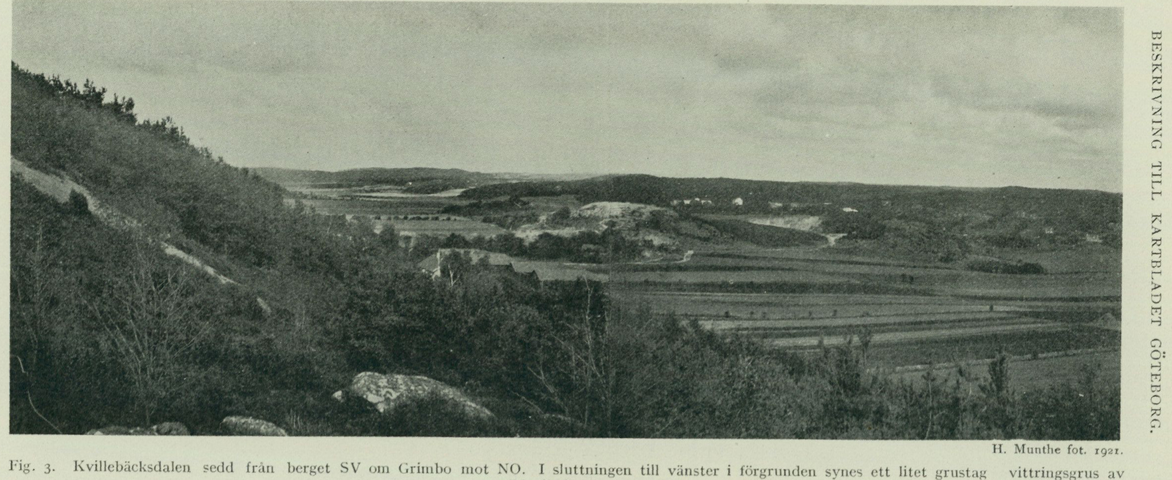
H. Munthe, photograph, 1921. Fig. 3. Kvillebäcksdalen seen from the hill SW of Grimbo toward NE. In the slope to the left in the foreground a small gravel pit is visible — weathering gravel of red alkaline gneiss.
Heading out from Värmlandsgatan, bedrock was not reached until 130 m below m. s. l. Fig. 4 is a profile of the valley from Ramberget through Sannegårdshamnen to Stigbergskajen. The greatest depth to solid rock probably also exceeds 100 m here. Whether any submarine valley of great depth in the bedrock continues out through Älvsborgsfjorden has not been determined, but judging from the shallow depth of the water here and the numerous rocky islets and shoals, this is unlikely.
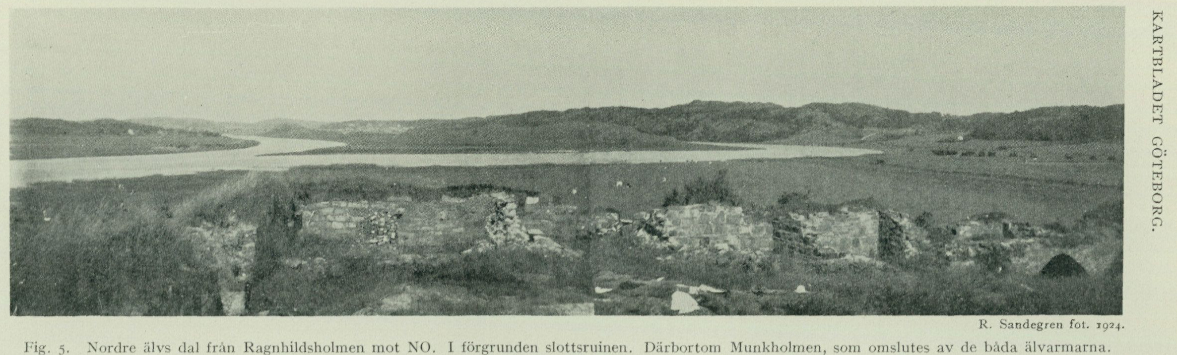
The Nordre älv valley (fig. 5) shows considerably less pronounced forms than Säveådalen, and the mouth area in Älvefjorden is so shallow that it does not permit anything but very small boats to enter Göta älv by this route.
Other valleys with this direction are the valley trending NE from Hinsholmen, followed by the Långedragsbanan, Lärjeådalen trending NE from Lärjeholm, followed by the Västgötabanan, a couple of smaller valleys at Sandviken and Flateby Sandvik in Harestads parish, as well as the valley that within Torsby parish can be followed from the seashore W of Gloshed, past St. Röd toward Staby.
The valleys with NW–SE direction, finally, are, probably for reasons that will be discussed below, less prominent in the topography than the valleys of the two previously treated directions. Two major valleys of this group should nevertheless be mentioned. One is the valley that extends from Älvefjorden NW of Björlanda kyrka past Lexby, Häljered and Bjurslätt to Göteborg, where it meets the Kvillebäcksdalen, Götaälvsdalen and Säveådalen. The other runs from the northern map margin at Ranneberg in Torsby parish past Harestads kyrka and continues onto Hisingen, where it meets the Kvillebäcksdalen N of Skändla.
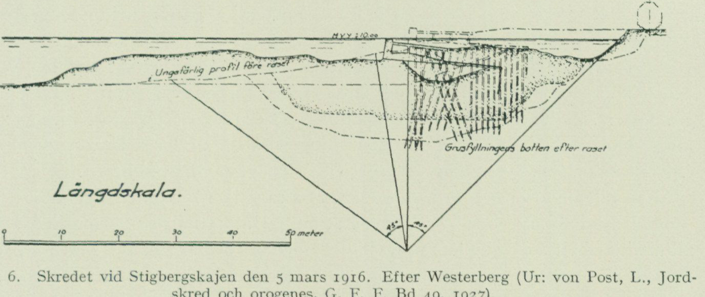
The unconsolidated deposits, which thus occur with great thickness within the valleys bounded by steep rock sides, frequently occupy a more or less unstable equilibrium position, which is why landslides and slides are quite common in these areas. The slides are usually triggered by altered loading conditions on thick clay layers with high water content and the consequent low shear strength.
In many cases, careful investigations have established that the slide mass has moved along a semi-cylindrical slip surface.¹ During this movement, one end of the slid clay mass has subsided, while the other has been pressed up, whereby the entire mass, after the slide, has come to occupy a more stable position.
According to Westerberg, the slide that occurred at Stigbergskajen on 5 March 1916 was probably of this type (fig. 6).
Another slide occurred during dredging in the basin of Sannegårdshamnen on 7 April 1911, when a soil mass of approximately 45,000 m³ slid out.
To a very great extent, landslides have occurred in both earlier and more recent times within the parts of the Göta älv valley lying north of map sheet Göteborg.¹² The river banks here show marks of slides virtually everywhere,
  1 Westerberg, Nils, Jordtryck i kohesionära jordarter, Tekn. Tidskr. 1931, V. o. V.
 2 Frödin, Gustaf, Jordskreden och markförskjutningarna i Göta älvs dalgång mellan Trollhättan och Lilla Edet. Medd. fr. Kungl. Vattenfallsstyrelsen N:o 19, Upsala 1919.

Sannegårdshamnen Göta älv Stigbergskajen
Bedrock
1600 1200 1000
Fig. 4. Profile from Ramberget across Sannegårdshamnen and Göta älv to Stigbergskajen, showing the configuration of the bedrock surface and the thickness and distribution of the Quaternary deposits. (Mainly after boreholes by the Göteborg Harbour Board.)
R. Sandegren, photograph, 1924. Fig. 5. The Nordre älv valley from Ragnhildsholmen toward NE. In the foreground the castle ruin. Beyond it Munkholmen, which is enclosed by the two river arms.
so-called landslide scar. Within the map-sheet area there is a distinct scar (marked on the map with a special symbol) from a large clay landslide in the valley between Skårdal and Bohus station. The landslide was probably of the so-called flask-shaped type, and the displaced masses may be the reason why the river is so narrow here. Regarding the time of the landslide, the historical records provide no information, but the name Jordfallet seems to indicate that the memory of the event has been preserved in oral tradition. A landslide that occurred in 1698 at Sävenäs, when a piece of ground 50 alnar long and 30 alnar wide together with a barn slid out into Säveån, is described by Urban Hjärne in »Den korta anledningen til åtskillige malm och bergarters efterspörjande och angivande». Andra flock Sthlm 1706 p. 170.
Fig. 6. The landslide at Stigbergskajen on 5 March 1916. After Westerberg (From: von Post, L., Jordskred och orogenes, G. F. F. Bd 49, 1927).
The area’s most important watercourses are Göta älv with its two distributaries, Nordre älv and the actual Göta älv. Into Göta älv flow from the left side Mölndalsån, Säveån and Lärjeån, from the right side Kvillebäcken. Into Nordre älv flow several small streams from both the Inland side and the Hising side. Other smaller streams, which drain Torsby, Björlanda and Torslanda parishes, discharge directly into the sea. The lakes are few and of insignificant size. Near the southeastern corner of the sheet lie Härlandatjärn, St. Delsjön and Långvattnet. The water of the two latter is now utilized for the Göteborg and Mölndal waterworks. Smaller parts of L. Delsjön, Rådasjön and Stemsjön, located E and S of these lakes, extend into the map area. All these lakes are drained through Mölndalsån. Within Angered and to a lesser extent within Nödinge parish lies Surtesjön, which together with a few other small lakes in the same area empties its water into Göta älv through small streams. On Hisingen there are only a few very small bodies of water, of which one at Holm in Tuve parish has been enlarged by damming, and one at Gerrebacka in Säve parish has been formed by converting a peatland into a fish pond. A certain interest attaches to three small pools in the western part of Rödbo parish, which indicate the position of a channel of Nordre älv that existed in earlier times. This
    arm thus ran from Ragnhildsholmen towards SW and can now be traced through
      the aforementioned lakes and the small peatlands connected to them, about which more
      below. Ragnhildsholmen is, moreover, now nearly landfast with Hisingen,
                 in that only at high water levels is the river channel running S of the island filled
        with water.
      During the earlier part of postglacial time, however, this area was quite
       rich in small lakes and tarns, in that most of the peatlands occurring here
      originated from such, which gradually became overgrown. This is evident from
      the layers of gyttja that as a rule underlie the peat in the area's fens and bogs.
Vegetation, A striking feature of the landscape is its poverty of forest. The archipelago’s settlement. islands, the coastal land, and the inland rocky plateaus are mostly entirely barren. The forests of oak and beech that, according to old records, formerly existed here have been ravaged, and regeneration is hindered by the constantly punishing westerly wind. As one approaches the coast from the sea, it gives an exceedingly barren and desolate impression, not a green patch, only bare rock, which in flat ridges rises one behind another in varying grey tones, as far as one can see inland. Only the heather sets, during sunny late-summer days, here and there a brilliant splash of colour in the grey monotony. But the valleys and the eastern slopes of the rocky heights, lying in the lee of the wind, host a rich and luxuriant vegetation. The clay lands of the valley bottoms are generally entirely cultivated, while the sheltered slopes are clothed in usually rather narrow strips of deciduous forest, where oak and linden are the characteristic trees. A clear impression of the forest’s scenery-like appearance is obtained, for example, during a road journey from Göteborg W out onto southern Hisingen to Hjuvik or N along Göta älv, where the lush greenery of the western valley side offers a sharp contrast to the grey bare rock of the eastern side. Here and there in the archipelago, especially on the islets located S of Hönö and also in a few places on SW Hisingen, scattered remnants of formerly more extensive stands of yew (Taxus baccata) are encountered in sheltered rock crevices. During recent decades, however, successful coniferous forest planting has taken place in many areas, whereby mountain pine (Pinus montana), due to its greater hardiness against wind, has been extensively used. Settlement is strictly confined to the valleys, whose marine deposits, rich in lime and loam, offer easily worked and excellent arable land. Despite the relatively small cultivable area, agriculture, by virtue of the good quality of the soils, constitutes an important source of livelihood and provides sustenance for a population that is unusually large in relation to the cultivated area. Particularly fertile is Hisingen, whose products, especially garden vegetables, find a good market in Göteborg. The main livelihood of the archipelago is fishing. The most important is herring fishing, but the catch of cod, ling, mackerel, etc. is also of great importance. The fishing population lives on the larger archipelago islands in densely built
communities, fishing villages. Among these may be mentioned Fotö, Hönö Klova, Kalvsund, Hällsö, Skarvik on Björkö, Knippla on Källö, Hyppeln, Brunskär and several others. The most significant concentration of settlement in the area is, naturally, the city of Göteborg, with which the parishes of Lundby and Örgryte have in recent times been incorporated. Göteborg is Sweden’s foremost commercial and maritime city, and in connection herewith it has also developed into a significant industrial centre. The present Göteborg was founded in 1619 and has expanded, so that a continuous urban development now also extends across the areas where its war-devastated predecessors lay, namely Nylödöse (now Gamlestaden), founded in 1473 at the mouth of the Säveån river into Göta älv, and the so-called Hisingska Göteborg, founded in 1603, which was located at the present Färjenäs.
The oldest city in the area was, however, Konungahälla, already mentioned in the 900s, which was situated at the present Kastellegården and during the Middle Ages was a very significant town. After having been ravaged and burned several times, the city was finally devastated in 1612 and was subsequently moved to the fortress islet of Bohus, where it received the name Kongelf. In its present location Kungälv was rebuilt in 1680, after having again been burned in 1676. It is now an idyllic small town.
The bedrock of the area belongs, apart from some younger diabase dikes, to the Precambrian basement, the oldest geological formation occurring on our Earth, and constitutes a part of the so-called western Swedish iron gneiss region. This is built up of a series of gneiss rock types that are rather varied in appearance and chemical composition, which are collectively referred to by the common designation iron gneiss, originally given to a fairly commonly occurring type within the said formation, characterized by small grains of magnetic iron ore (magnetite). No certain or generally accepted explanation regarding the original mode of formation of the iron gneiss is yet available, but there are nevertheless several things that appear to speak in favour of the view that, at least within the area in question, it originated from magma masses that solidified during a very early stage in the Earth’s developmental history, and which through so-called magmatic differentiation were partitioned into the chemically and structurally diverse rock types that we now find side by side in banded alternation within our iron gneiss terrains.
The gneiss bedrock received, already during Precambrian time, partly perhaps even before solidification, through various kinds of movement a folded and crumpled structure, which now manifests itself both in its large-scale attitude and in its detailed character. The landforms that prevailed on the Earth’s surface during Precambrian time were subsequently obliterated through a prolonged and profound denudation, whereby a generally flat surface, within the area here in question slowly sloping toward the W, was created — a so-called peneplain. Owing to the fact that considerable masses of the upper layers of the Earth’s crust were removed during peneplain formation, this surface now displays the uplifted gneiss layers more or less obliquely truncated, so that they appear as along the strike continuously, now interrupted, now more coherent, crumpled bands.
During the Cambrian period the sea transgressed over the area, and on the peneplain the sandstones, shales, and limestones of the Cambro-Silurian succession were deposited, which rock types are still preserved in Halle- and Hunneberg as well as the other Västgötabergen mountains. The peneplain is therefore usually designated as sub-Cambrian. After the Silurian period the sea retreated from our country, and the Cambro-Silurian rocks were subjected to the destructive activity of weathering and running water. This landscape sculpture, continuing through the later part of the Paleozoic, the entire Mesozoic, and during the Tertiary, led to the removal of the greater part of the Cambro-Silurian rocks, and we therefore find them preserved only in such places where they were protected from destruction by having been downfaulted, as on the Närke plain, or having been covered by hard and resistant diabase beds, as on the table mountains of Västergötland.
During the immense spans of geological time that have elapsed since the Earth received a solid crust, this crust has been subjected to many different kinds of movement that generated stresses, which were released through the formation of numerous cracks running in different directions. The fracture lines within an area usually form a number of distinct systems, which intersect each other at different angles. Within the Göteborg map sheet, fracture systems with the following directions are generally represented: N—S, NNE—SSW, NE—SW, ENE—WSW, NW—SE, WNW—ESE, whereas fractures with a due W—E direction are more rare. In fractures with NNE—NE direction, diabase magma already intruded in Precambrian time (the area’s older diabase dikes), while during a later stage (uncertain whether Precambrian or Paleozoic) a diabase intrusion took place in fractures with WNW direction (the younger diabase dikes). Particularly intense movements appear to have taken place along the largely N—S-trending fracture zone that forms the foundation of Tolltorpsdalen and its continuation, Kvillebäcksdalen, in that the rocks here exhibit strongly pronounced crushing and mylonitization phenomena. The assumption that the N—S-trending fractures would be of post-Silurian age is based on the circumstance that the rhomb porphyry, which in the northern and middle Bohuslän archipelago occurs in fractures with this direction, is demonstrably post-Silurian.
When the old Precambrian peneplain, as mentioned above, after the Silurian period was again exposed and subjected to the eroding forces, the crushed bedrock along the fracture lines offered much weaker resistance to these than the intact rock masses lying between the fracture lines, and thus the sculpting-out of the valleys began, which were mentioned above and whose location and direction are in the most intimate manner dependent on the fracture lines. The relief that arose solely through this pre-Quaternary landscape sculpture was, however, presumably not nearly as sharp as the present one. For this we have to thank the glaciation that struck our country and the greater part of northern Europe at the beginning of the Quaternary period. What weathering and running water had failed to accomplish, the mighty continental ice sheet achieved.
As the inland ice advanced over the area, it first and foremost swept away
the large quantities of weathering material and other loose sediments, which had accumulated during pre-Quaternary time, especially in the valleys. Thereafter, its attack on the solid bedrock itself commenced. The ice’s action on its substrate is essentially of two kinds: partly a wearing and grinding, in which the entrained till material serves as an abrasive, partly a plucking and quarrying, in which larger and smaller rock fragments are taken up
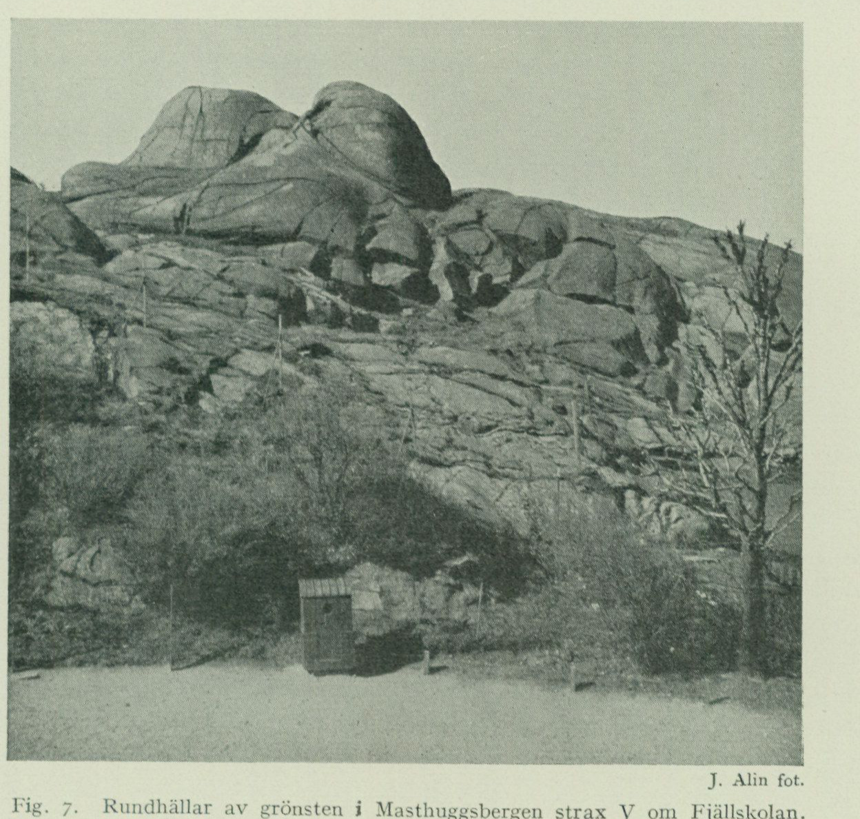
J. Alin, photograph. Fig. 7. Roches moutonnées of greenstone in the Masthuggsbergen immediately W of the Fjällskolan.
by the advancing masses and incorporated into the till. Which of these two modes of action of the ice plays the greatest role in each individual case depends mainly on the nature of the bedrock itself. Where this is joint-free and hard, erosion has essentially consisted merely in a grinding down. Larger quantities of solid rock could then scarcely have been denuded away. Through the gradually occurring planing, the rock surfaces acquire smooth and rounded forms (roches moutonnées, fig. 7), which offer the least possible resistance to the advancing ice mass. The side of the rock surfaces facing the direction from which the ice moved (the stoss side), thus displays a beautifully vaulted, smoothly polished surface, on which one can often see the striations and grooves that exactly indicate the ice’s direction of movement. The opposite side, on the other hand (the lee side), is often steep or exhibits irregularities that, owing to their position, were sheltered from grinding but owe their origin to plucking. Where the bedrock, in turn, is fissured and strongly fractured, as is the case—
especially along the crushing zones of the fracture lines, the ice’s plucking and quarrying activity could make itself felt on a larger scale. Fractures and irregularities provide good points of attack, and along the crush zones, where the bedrock had already been loosened by the pre-Quaternary weathering, the ice was therefore able to easily clear out and excavate valleys and depressions. In this way, the characteristic rift valleys of the area have originated. It is striking how the valleys are deepest eroded and often widen into low-lying, irregularly shaped plain areas where fractures belonging to different systems meet or cross each other. In such places the bedrock is even more shattered than along a single fracture zone. One such intersection point of numerous fractures is precisely the area where the city of Göteborg now lies. A circumstance that offered particularly favourable conditions for erosion within the fracture systems trending N—S and NE—SW is that the general direction of ice movement during two of the glaciation’s main phases broadly coincided with their longitudinal direction. From the above it follows that the major features of the area’s topography are conditioned by and reflect its development during the various geological epochs. The large bedrock plateaus, which rise to approximately the same, gently westward-dipping level surface, are remnants of the once continuous sub-Cambrian peneplain. The valleys mark those shattered parts removed from this peneplain by weathering, running water, and finally ice. If, from some elevated vantage point, e.g. Masthuggsberget, Ramberget, Slottsskogen, or the heights E of Lärje station, one gazes out over the landscape, these features emerge with extraordinary sharpness. The loose soil layers, which mainly occur as partial infill in the bedrock’s valleys and depressions, originated during and after the Ice Age. They consist partly of such crushed rock material as the inland ice left behind upon its melting away (till, glaciofluvial gravel), partly of marine deposits (beach gravel, sand, clay, gyttja), laid down in the seas that, after the Ice Age, spread over large parts of the area, and partly finally of such deposits as originated after the land had risen from the sea (peat formations etc.). These loose soil layers bear, as we shall see in the following, witness to the area’s varied and interesting developmental history during the Quaternary right up to our own days. As the land rose from the sea, both rock and soil types were anew exposed to the influence of atmospheric weathering. Hereby transformations take place within the surface layers of the soil types, e.g. leaching of lime and other readily soluble substances. The surfaces of rock outcrops are attacked, so that, e.g., the striations incised by the inland ice have in many places been obliterated. Through frost shattering, larger and smaller blocks are loosened, especially from precipitous rock faces, which fall down and accumulate at the foot of the cliff to form talus deposits. Through the weathering away of crushed rock along fault fractures, cavities or caves occasionally arise, usually in more or less steep rock faces. One such is found in Backa parish ca. 1 km S of the church in the northern
cliff of the local mountain height. It is 1 m high and 1 m wide at the opening and extends 2 m into the rock. Another such cave, named Kansås stuga, is located in Torsby parish ca. 1 km WSW of the church in the rock cliff N adjacent to the eastern end of the so-called Hålisungs mosse and ca. 15 m above the surface of the bog. The cave is 5 m high and 4 m wide at the mouth and extends ca. 8 m into the rock. According to legend, it formerly served as a lair for robbers and is protected by a massive stone barricade, probably constructed by human hand, at the entrance. An unusually easily weathered rock type is the red alkaline gneiss, which occurs in a band across the entire map sheet. It is, especially within several elevated areas, such as Änggårdsbergen S of Göteborg, at Grimbo in Tuve parish and SE of Säve church, so thoroughly weathered right down to a couple of metres’ depth below the surface of the “rock outcrops”, that it can be dug with a spade and advantageously used for road gravel. After this general overview of the area’s geological development, we may proceed to a closer description of the rock and soil types occurring within the sheet and to a more detailed presentation of the area’s geology.
The Bedrock.
By H. E. Johansson.
The bedrock on map sheet Göteborg is built up almost exclusively of gneiss and greenstone rock types, belonging to the Precambrian gneiss formation extending across western Sweden, which is usually designated as the iron gneiss formation. From a more specialized gneiss-geological viewpoint, the local segment of the “iron gneiss” exhibits a facies development characterized primarily by the strong predominance of grey plagioclase-rich gneiss varieties, which may generally be said to be typical of the more westerly parts of the iron gneiss area. As a more subordinate component in the gneiss basement, a more or less abundant admixture of pegmatite occurs. — This Precambrian basement is cut by a number of clearly younger dikes, otherwise hardly determinable with certainty as to their geological time of formation, consisting of diabases or diabase-like greenstones belonging to two sharply distinct dike systems: the older with a NE–SW principal trend and, by all indications, equivalent to the so-called Koster diabases known from more northerly parts of the Bohuslän archipelago; the younger with a pronounced WNW–ESE dike trend. Otherwise, the continuity within the map area’s gneiss basement — so far as can be judged — is interrupted only by two fracture zones, both topographically and petrographically more marked, which traverse the map sheet in a N–S direction and are followed, at least in stretches, by pronounced mylonite, breccia, and vein quartz zones.
The Precambrian Gneiss Basement.
Petrographic character and classification of the gneiss formation.
The gneiss bedrock is generally characterized by a lively variation, often continuing in detail, between more or less sharply contrasting petrographic rock varieties. In their mineralogical composition, these rock types correspond essentially to a series of combinations between the constituents quartz, potassium feldspar, soda-lime feldspar (plagioclase), and certain iron- and magnesia-bearing dark-coloured minerals, usually biotite or hornblende, varied in a manner that is regular to a certain degree. Of these constituents, the feldspar minerals constitute together more than half (in many types approximately 60 to 65 %) of the rock mass in the main part of the area’s gneisses, and it is primarily the variations in the composition and proportions of these constituents that give rise to the existing variations in the
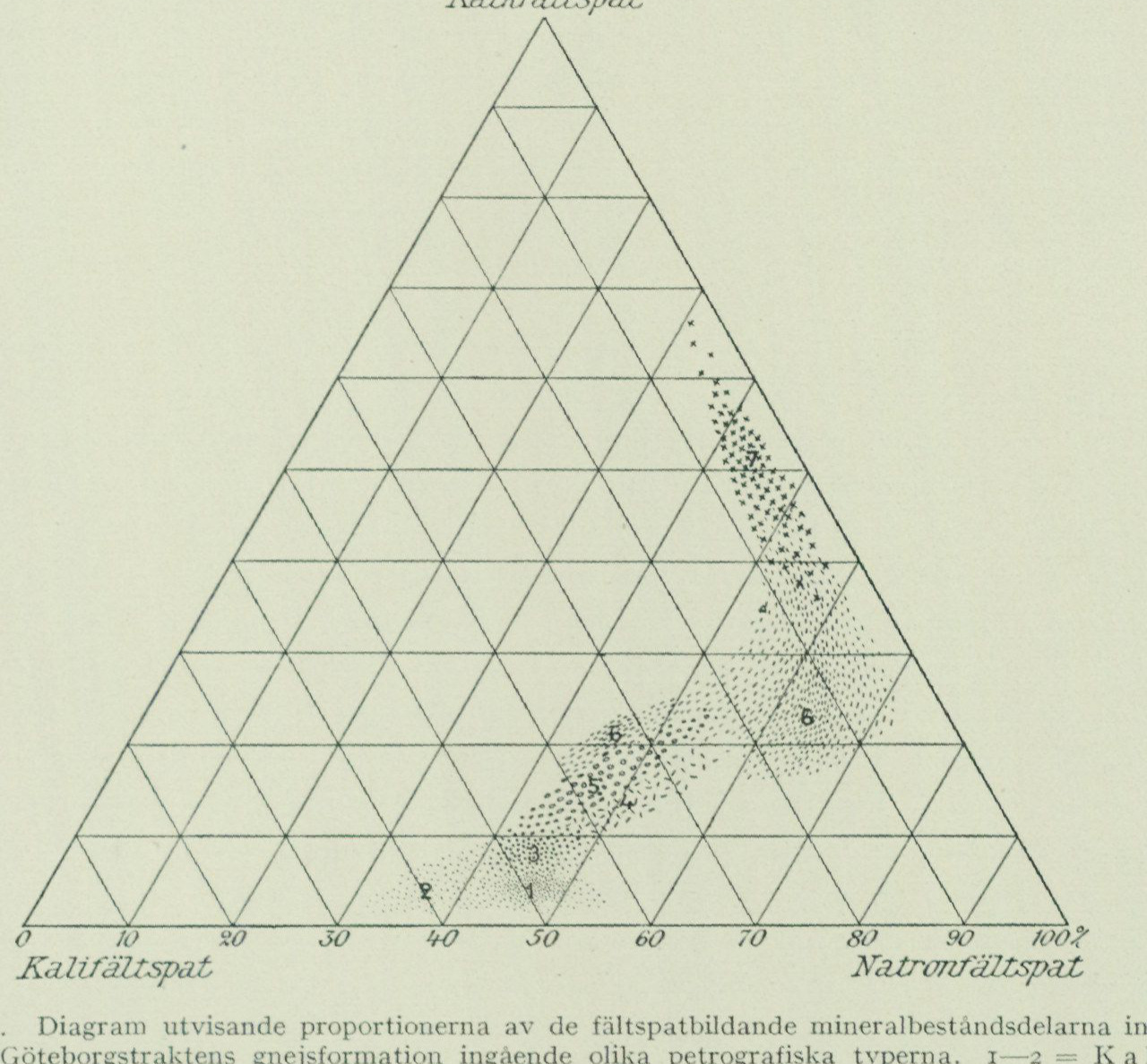
rocks’ external appearance such as colour, grain size, etc., all the more so as the proportions of the other constituents — or at least of the dark-coloured minerals — generally prove to be closely related to the feldspar composition. The potassium feldspar mineral in the gneisses appears invariably to be microcline perthite with a certain, though according to the microscopic characters not greatly varying, content of soda feldspar silicate (mostly approximately 20 to 25 %); the plagioclase, on the other hand, varies in different rock varieties from slightly calcic albite (in certain red “alkaline” gneisses) up to andesines with 40–45 % lime feldspar silicate (in certain grey gneisses) or still more calcic members (in the greenstone-like rock units). Among other mineral constituents, epidot has a comparatively abundant and constant distribution in the area’s more calcic gneiss varieties, while muscovite occurs as a more essential constituent mainly in certain varieties of grey gneisses. Regarding the mineral composition of the gneisses, reference may otherwise be made to the compilation in tab. 1, which presents the results of volume measurements in microscopically examined thin sections of a series of representative samples of the map area’s more important gneiss types. The average composition of the feldspar-forming constituents of the rocks (expressed in molecular percentages of the potassium-, soda-, and lime feldspar silicate components entering into the feldspar minerals), as it can be more approximately calculated solely from the microscopically determinable qualitative characters and quantitative relations of the feldspar minerals, is illustrated in the schematic diagram fig. 8, which is primarily intended to show the characteristic ranges of variation for different petrographic types with respect to the composition of the feldspar-forming constituents.¹ During the bedrock mapping, a subdivision of the area’s gneiss series into three petrographic divisions was undertaken in the first instance, these generally being distinguishable with certainty already in the field solely on the basis of the rocks’ external appearance, and designated as respectively red lime-poor feldspar gneisses, intermediate gneisses, and grey plagioclase-rich gneisses. As a fourth, more basic division, the greenstone rocks associated with the gneisses are added.
The red lime-poor feldspar gneisses (tab. 1, No. Red gneisses. 1–6) are characterized by a low content of lime feldspar silicate (fig. 8) and a correspondingly lime-poor composition of the rock plagioclase (albite or albite-oligoclase with up to 10 to 15 % lime feldspar silicate) together with an abundant content of potassium feldspar and the resulting generally pronounced red colour tone of the rocks; the quartz content is quite high in more typical gneiss varieties of this group (30 to 35 %), while the amount of dark-coloured minerals
¹ Dr. Johansson had also intended to include in table I the thus-calculated feldspar proportions for the examples of different gneiss types from the map sheet treated there. This calculation has unfortunately not been possible to complete, as a fully satisfactory identification of the surviving material for this purpose has not been possible.
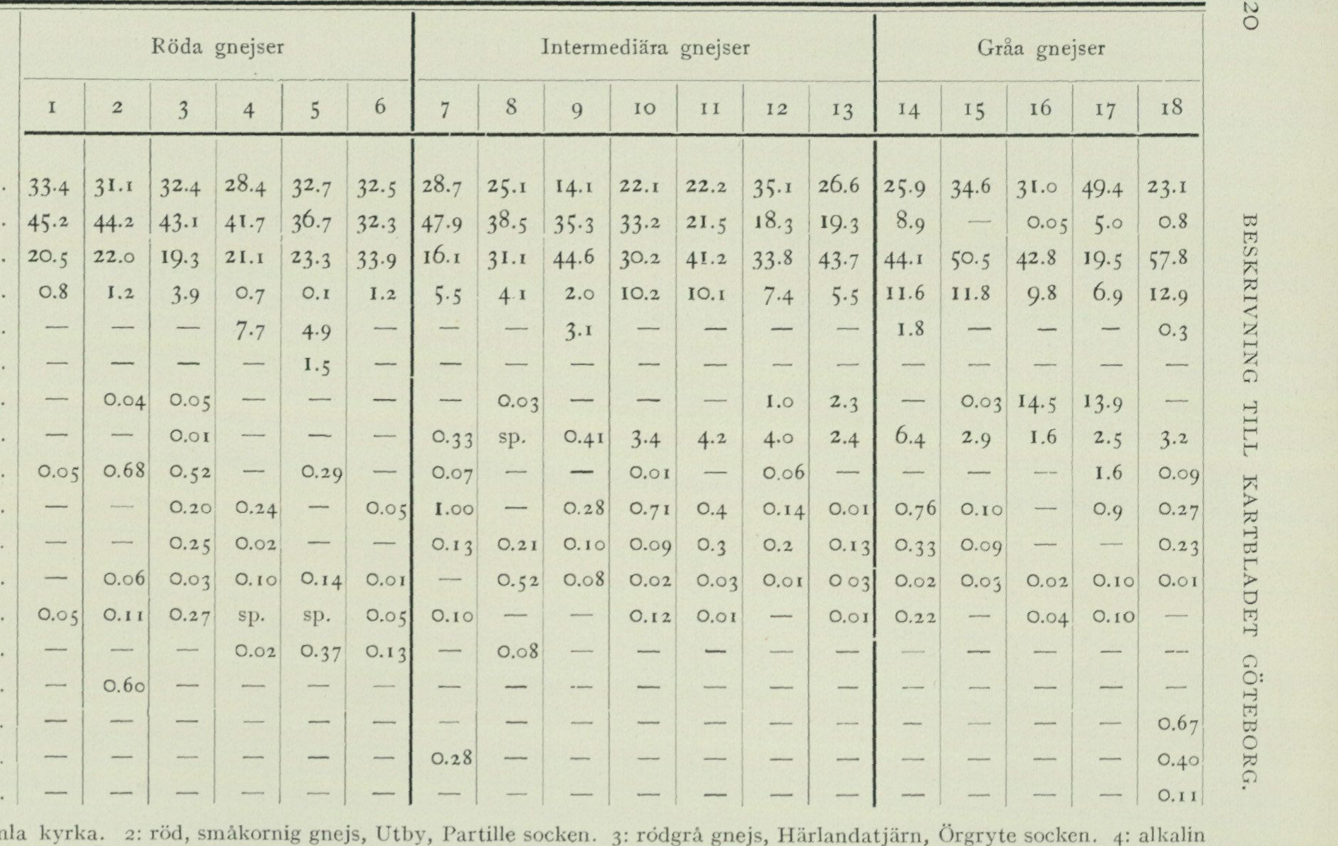
Table I.
Columns 1–6 are red gneisses, 7–13 intermediate gneisses, and 14–18 grey gneisses. A dash is printed absence; sp. is the printed trace designation. The complete source-pixel table is retained with this page.
| Mineral | 1 | 2 | 3 | 4 | 5 | 6 | 7 | 8 | 9 | 10 | 11 | 12 | 13 | 14 | 15 | 16 | 17 | 18 |
|---|---|---|---|---|---|---|---|---|---|---|---|---|---|---|---|---|---|---|
| Quartz | 33.4 | 31.1 | 32.4 | 28.4 | 32.7 | 32.5 | 28.7 | 25.1 | 14.1 | 22.1 | 22.2 | 35.1 | 26.6 | 25.9 | 34.6 | 31.0 | 49.4 | 23.1 |
| Microcline-perthite | 45.2 | 44.2 | 43.1 | 41.7 | 36.7 | 32.3 | 47.9 | 38.5 | 35.3 | 33.2 | 21.5 | 18.3 | 19.3 | 8.9 | — | 0.05 | 5.0 | 0.8 |
| Plagioclase | 20.5 | 22.0 | 19.3 | 21.1 | 23.3 | 33.9 | 16.1 | 31.1 | 44.6 | 30.2 | 41.2 | 33.8 | 43.7 | 44.1 | 50.5 | 42.8 | 19.5 | 57.8 |
| Biotite | 0.8 | 1.2 | 3.9 | 0.7 | 0.1 | 1.2 | 5.5 | 4.1 | 2.0 | 10.2 | 10.1 | 7.4 | 5.5 | 11.6 | 11.8 | 9.8 | 6.9 | 12.9 |
| Hornblende | — | — | — | 7.7 | 4.9 | — | — | — | 3.1 | — | — | — | — | 1.8 | — | — | — | 0.3 |
| Pyroxene | — | — | — | — | 1.5 | — | — | — | — | — | — | — | — | — | — | — | — | — |
| Muscovite | — | 0.04 | 0.05 | — | — | — | — | 0.03 | — | — | — | 1.0 | 2.3 | — | 0.03 | 14.5 | 13.9 | — |
| Epidote | — | — | 0.01 | — | — | — | 0.33 | sp. | 0.41 | 3.4 | 4.2 | 4.0 | 2.4 | 6.4 | 2.9 | 1.6 | 2.5 | 3.2 |
| Magnetite | 0.05 | 0.68 | 0.52 | — | 0.29 | — | 0.07 | — | — | 0.01 | — | 0.06 | — | — | — | — | 1.6 | 0.09 |
| Titanite | — | — | 0.20 | 0.24 | — | 0.05 | 1.00 | — | 0.28 | 0.71 | 0.4 | 0.14 | 0.01 | 0.76 | 0.10 | — | 0.9 | 0.27 |
| Apatite | — | — | 0.25 | 0.02 | — | — | 0.13 | 0.21 | 0.10 | 0.09 | 0.3 | 0.2 | 0.13 | 0.33 | 0.09 | — | — | 0.23 |
| Zircon | — | 0.06 | 0.03 | 0.10 | 0.14 | 0.01 | — | 0.52 | 0.08 | 0.02 | 0.03 | 0.01 | 0.03 | 0.02 | 0.03 | 0.02 | 0.10 | 0.01 |
| Orthite | 0.05 | 0.11 | 0.27 | sp. | sp. | 0.05 | 0.10 | — | — | 0.12 | 0.01 | — | 0.01 | 0.22 | — | 0.04 | 0.10 | — |
| Fluorite | — | — | — | 0.02 | 0.37 | 0.13 | — | 0.08 | — | — | — | — | — | — | — | — | — | — |
| Garnet | — | 0.60 | — | — | — | — | — | — | — | — | — | — | — | — | — | — | — | — |
| Scapolite | — | — | — | — | — | — | — | — | — | — | — | — | — | — | — | — | — | 0.67 |
| Carbonate | — | — | — | — | — | — | 0.28 | — | — | — | — | — | — | — | — | — | — | 0.40 |
| Pyrite | — | — | — | — | — | — | — | — | — | — | — | — | — | — | — | — | — | 0.11 |
1: red, fine-grained gneiss, Lundby gamla kyrka. 2: red, fine-grained gneiss, Utby, Partille parish. 3: red-grey gneiss, Härlandatjärn, Örgryte parish. 4: alkaline gneiss, NW of Backa kyrka. 5: alkaline gneiss, Änggården, Göteborg. 6: alkaline gneiss, Käringtorp, Säve parish. 7: intermediate, even-grained gneiss, Lundby gamla kyrka. 8: Lundby gneiss, W of Tuve kyrka. 9: intermediate gneiss, Järnbrott, V. Frölunda parish (just outside the southern sheet boundary). 10: Askim gneiss, Tranered, V. Frölunda parish. 11: Ryanabb gneiss, E of Vikan, Björlanda parish. 12: Frölunda gneiss, Ekebäck, V. Frölunda parish (just outside the southern sheet boundary). 13: Frölunda gneiss, Saltholmen, V. Frölunda parish. 14: grey gneiss, Bohus fästningsholme. 15: grey gneiss, Öxnäs, Säve parish. 16: two-mica gneiss, St. Varholmen, Torslanda parish. 17: two-mica gneiss, Bockskären, Styrsö parish. 18: grey gneiss, E of Lärjeholm, Angered parish.
As a summation shows, not all of the calculations carried out end in a sum of exactly 100.00%. The deviation is generally less than 0.10, in one case, however, 0.36. Considering that rounding should perhaps not be done entirely mechanically, Johansson’s primary figures have been retained throughout here. Cf. also note p. 19.
is slight; the texture is equigranular, without any tendency to an augen-shaped development of the potash feldspar. Among the gneisses belonging here may be distinguished on the one hand a more potash-rich type of generally pale-red, fine-grained, aplitic gneisses with very insignificant content of dark minerals (No. 1—2) and on the other hand a more soda-rich, more »alkaline» type of often strongly red-coloured and in the
Lime feldspar
Fig. 8. Diagram showing the proportions of the feldspar-forming mineral components within the different petrographic types included in the gneiss formation of the Göteborg area, 1—2 = Lime feldspar-poor gneisses. 1 = red, alkaline type. 2 = red, fine-grained type. 3—5 = Intermediate gneisses. 3 = poorer in lime feldspar, lighter red, equigranular or augen-gneissic types. 4 = richer in soda feldspar, greyish types (Frölunda gneiss, Ryanabbs- gneiss). 5 = richer in lime feldspar, darker red types (Askims gneiss, Eastern augen gneiss). 6 = Grey, plagioclase-rich gneisses. 7 = Greenstones.
whole somewhat coarser-grained, preferably fluorite-bearing gneisses with a more prominent content of dark minerals, the latter being represented here by particularly iron-rich mineral varieties (No. 5—6). To the former type belongs an aberrant type occurring within the southeasternmost part of the map area of gneisses richer in lime feldspar and dark minerals (mica) of a more red-grey colour tone (No. 3).
The intermediate gneisses (No. 7—13) are distinguished from the Intermediate preceding division by a higher content of lime feldspar silicate and carry as gneisses. feldspar mineral potash feldspar in combination with more lime-rich plagioclase (oligoclase with 15 up to 25 to 30 % anorthite silicate), to which is added a more abundant,
     with the lime feldspar content rising admixture of dark-coloured minerals (about
     5 up to 10 to 15 %). The colour is more or less distinctly red-brown.
     Structurally, the gneiss forms belonging here are in general characterized by a
    prominent tendency in the potash feldspar to form larger crystals or
     grain aggregates (»eyes») and a simultaneous flaser-like accumulation of the dark
     minerals, owing to which these gneisses as a whole present a coarser
    appearance in comparison with the other petrographic variants
      included in the gneiss series. Otherwise, among these gneisses several variation types, rather characteristic
            both in composition and appearance, may be distinguished, which
   essentially characterize geologically separate tracts within the gneiss formation and
   will be more closely characterized in connection with the description of the formation's
     geological structure.
Grey The grey plagioclase-rich gneisses (14—18) are characterized gneisses. most closely by the fact that the feldspar mineral of the rocks is predominantly or often entirely composed of plagioclase, whereby the colour tone of the rocks in general becomes grey and the texture equigranular and mostly rather fine-grained. The extensive areas of the map sheet occupied by the gneiss forms belonging here are distributed regionally into mainly three chemical-petrographic variation types of grey gneisses. Within the grey-gneiss tracts in the eastern part of the map sheet the rocks are of a comparatively lime-rich but not particularly quartz-rich type (the plagioclase feldspar of andesine composition with 40 to 45 % anorthite- silicate, the quartz content about 25 %) of pronounced iron-gneiss crystalline texture (tab. No. 18); within the map sheet’s central grey-gneiss area the rocks are of a distinctly more lime-poor feldspar composition (oligoclase with 25 to 30 % An) and simultaneously higher quartz content (30 to 35 %), while the texture tends toward a more massive or somewhat flaser »ur-granitic» development (No. 14—15); farther westward within the actual coast and archipelago belt the predominant rock type consists of grey gneisses with a high content of mica minerals — mostly both dark and light mica — and a simultaneous high quartz content, while conversely the feldspar content as a whole falls below the proportions ordinary for granitic quartz-feldspar rocks (No. 16—17); gneisses of this type are simultaneously characterized structurally by a pronounced heterogeneity with a streaky distribution between darker mica- rich and lighter feldspar-richer portions. To the grey plagioclase-rich gneisses belong for the rest some boundary forms with a more considerable content of potash feldspar, which latter component in certain forms of such gneisses is predominantly found segregated into distinctly prominent red streaks or else more evenly distributed larger crystal grains or »eyes» but in other cases, particularly in the grey lime-rich gneisses in the eastern part of the map sheet, can scarcely be said to make itself distinctly known in the texture and appearance of the rocks. As a boundary type within the division, finally, are to be mentioned certain, quantitatively usually more subordinate, basic and mostly hornblende-bearing rock members, which both petrographically and in many* cases also geologically mediate the transition to the greenstones of the gneiss formation.
Greenstones. This division finally comprises those rock units, Greenstones, in which dark minerals occur as an essential constituent in combination with calcic plagioclase. As is usual with regard to rocks of this kind, the greenstones of the Göteborg sheet exhibit great variations in their petrographic character. On the whole, two more characteristic principal types may be distinguished within the greenstone series represented here, which also display certain differences in their geological occurrence. The one comprises well-defined hornblende greenstones of a more dioritic character. The plagioclase in these greenstones — in composition usually a calcic andesine with 40—50 % anorthite — is of whitish colour and rather isometric or thick tabular habit, and the rocks in their entirety have a coarser and lighter, black-and-white mottled appearance. The greenstones of this type furthermore mostly exhibit a strongly variable composition with intermixing of, on the one hand, more hornblenditic, on the other hand, light plagioclase gneissic rock forms, and are often more closely connected with surrounding gneisses through transitional rocks. The second type, designated on the maps as “greenstones of hyperitic or noritic type”, is represented by a series, occurring within certain rock belts in the eastern half of the map area, of often pyroxene- and garnet-bearing, dark and “heavy” greenstone rocks of generally finer-grained texture and more massive appearance, more strongly contrasting with the surrounding gneiss rocks. The plagioclase mineral in these greenstones, or at least in the pyroxene-bearing forms within the series, is of somewhat more calcic composition — generally labradorites with 50 to 60 % anorthite — and occurs as more elongated lath-shaped, or thin tabular, crystals, usually brown-coloured by a dark pigment, owing to which rocks of this type are generally characterized by a more or less pronounced diabase-like appearance, most closely resembling certain forms of the hyperite rocks occurring within the more easterly parts of the iron-gneiss area.
No systematic chemical investigation of the various rock types constituting the gneiss formation of the Göteborg area has as yet been obtainable. With regard to some of the gneiss varieties outcropping within the city of Göteborg or in its immediate vicinity, however, a number of analyses are available, previously published by Holmquist in his work on Swedish granites1 and here reproduced in the following table 2. Of these analyses, I and II correspond to rocks of the red fine-grained gneiss type, III to a more calcic somewhat augen-structured border form of the red alkaline gneisses of the area, and IV to a calcic type within the division of intermediate gneisses. In connection with the analyses, the percentages calculated therefrom for the average feldspar composition of the rocks are given. Owing to the high content of epidote in rock No. IV, the values calculated from the analyses indicate a considerably higher content of lime-feldspar silicate in comparison with the values calculated from microscopic feldspar determinations for rocks of corresponding petrographic type, and the same may, for analogous
1 P. J. Holmquist: Studien über die Granite von Schweden. Bull. Geol. Inst. of Upsala VII, 1906.
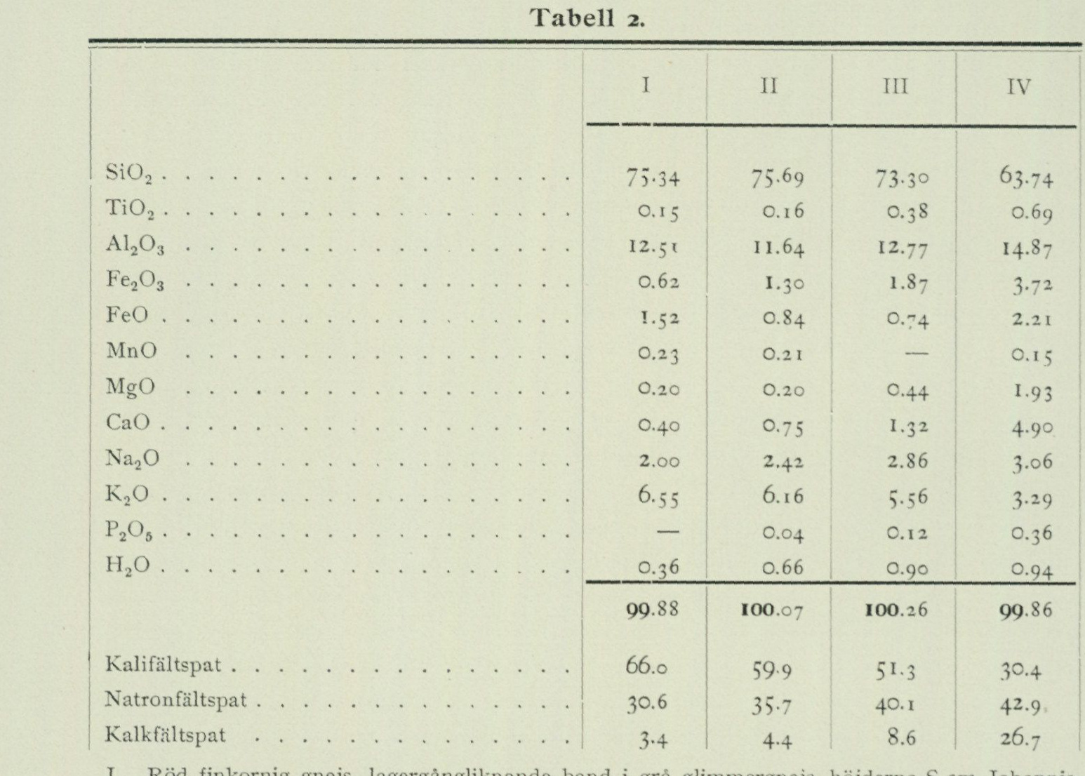
Table 2.
| I | II | III | IV | |
|---|---|---|---|---|
| SiO₂ | 75.34 | 75.69 | 73.30 | 63.74 |
| TiO₂ | 0.15 | 0.16 | 0.38 | 0.69 |
| Al₂O₃ | 12.51 | 11.64 | 12.77 | 14.87 |
| Fe₂O₃ | 0.62 | 1.30 | 1.87 | 3.74 |
| FeO | 1.54 | 0.84 | 0.74 | 2.21 |
| MnO | 0.23 | 0.21 | — | 0.15 |
| MgO | 0.20 | 0.20 | 0.44 | 1.93 |
| CaO | 0.40 | 0.75 | 1.32 | 4.90 |
| Na₂O | 2.00 | 2.42 | 2.86 | 3.06 |
| K₂O | 6.55 | 6.16 | 5.56 | 3.49 |
| P₂O₅ | — | 0.04 | 0.12 | 0.36 |
| H₂O | 0.36 | 0.66 | 0.90 | 0.94 |
| Total | 99.88 | 100.07 | 100.26 | 99.86 |
| Potash feldspar | 66.0 | 59.9 | 51.3 | 30.4 |
| Soda feldspar | 30.6 | 35.7 | 40.1 | 42.9 |
| Lime feldspar | 3.4 | 4.4 | 8.6 | 26.7 |
I. Red fine-grained gneiss, sill-like band in gray mica gneiss, the heights S of Johannis church, Göteborg. Analyst: E. Östlund. II. Red fine-grained gneiss, sill-like band, Vegagatan, Göteborg. Analysts: R. Mauzelius and O. Berg. III. Red somewhat augen-structured gneiss, the water tower in Slottsskogen, Göteborg. Analyst: R. Mauzelius. IV. Red biotite-rich gneiss, Nya Varvet, Göteborg. Analyst: O. Berg.
reasons (probably because of hornblende and fluorite content), be assumed to apply to some extent also to rock No. III; but these figures should in any event serve to further illustrate the differences in the chemical-mineralogical composition of the rocks that underlie the petrographic division of the area’s gneiss formation applied during the mapping.
Geological structure of the gneiss formation.
As far as can be judged from the conditions within those parts of the western Swedish gneiss area that have so far been subject to more detailed mapping — principally the southernmost parts of the area and the districts around Vänern — the iron gneiss formation appears, in its geological structure, to be chiefly characterized by a certain stratigraphic regularity. The various petrographic members of which the formation is composed appear geologically mostly as conformable, often strongly crumpled and winding bands, which arrange themselves after one another in a more or less regular stratigraphic succession and in many cases have proven persistent over considerable distances. As is more closely illustrated by the bedrock map, such a »banded architecture» is on the whole well marked also within the gneiss bedrock of the Göteborg area.
In tectonic terms, the present portion of the iron gneiss formation appears to be characterized by a more or less strong overthrusting in a predominantly west–east direction, as a result of which the distinguishable rock bands extend through the area in a broadly pronounced north–south orientation with predominantly westerly dips. The rock bands thus present themselves — apart from a constrictional structure that appears in detail within many parts — by and large as a continuous series of stratigraphic units lying successively »deeper» towards the east.
In the following account of the geological structure of the formation, the more important structural units included therein will be described in somewhat greater detail in essentially the same order in which they appear stratigraphically arranged in the field. With regard to certain more marked differences in the chemical-petrographic character of the rocks that appear within the formation, the individual rock zones distinguished on the bedrock map could conveniently be grouped into 4 main divisions.
I. Grey streaky two-mica gneisses in the Göteborg archipelago. The westernmost and, according to the general dip conditions, apparently »uppermost» division within the map sheet’s gneiss formation consists of a petrographically well-defined zone of distinctly streaky, more or less muscovite-rich grey gneisses, which occupy the entire archipelago, the southwesternmost part of Hisingen, and the greater part of Lycke and Torsby parishes in Inlandet. The further extension to the north is not yet known in detail, but gneisses of petrographically fairly identical character have been observed in several places along the zone’s field direction within the map sheet »Uddevalla», for example on the islands in Havstensfjorden and outside Ljungskile. Regarding the possible continuation to the south, it can only be noted here that no gneisses of corresponding character are known within the entire portion of the western Swedish coastal region lying south of the Styrsö archipelago. In general, these streaky two-mica gneisses occurring in the coastal areas of Göteborg and Bohuslän appear to represent a rock type rather unusual for the gneiss region of western Sweden as a whole, but one that petrographically more closely corresponds to certain forms of »streaky and banded» gneisses that are widely distributed within the grey gneiss belts of eastern Sweden.
As briefly noted in the petrographic overview, the streaky two-mica gneisses are distinguished in their mineralogical composition from the area’s other plagioclase gneisses primarily by a distinctly higher content of quartz and mica minerals relative to the feldspar content, which latter in typical rock varieties probably constitutes only 40 to 50 % of the rock mass, and in more extreme rock portions may decrease to the point where the rock begins to assume a somewhat quartzitic or mica schist-like appearance. From the mineralogical composition it may be concluded that the rocks within this division of the gneiss formation chemically correspond to an alkali-poorer but comparatively alumina-rich variant among the area’s grey gneisses. As is generally the case in such alumina-richer gneisses, the biotite mineral in the streaky two-mica gneisses readily displays a brownish, in thin section chestnut-brown
colour. As another characteristic detail of alumina-richer gneisses, one could also mention the general occurrence of minor quartz impregnations within certain gneisses belonging here, for example on Björkö. With regard to the character of the rocks in other respects, however, it is noteworthy that no special alumina silicate minerals, such as sillimanite or cordierite, have been observed anywhere within the present rock zone, and even garnet must be regarded as a rather rare constituent in the gneisses found here.
A general feature of the rocks within the archipelago belt is their extreme inhomogeneity, which is here displayed in a magnificent manner everywhere on the smoothly polished shore cliffs. In general, the more pronounced two-mica gneisses here exhibit a recalcitrant and streaky structure, caused by the fact that a portion of the rock’s quartz and feldspar components tends to form lighter, more coarsely crystalline segregations within the remaining fine-grained and mica-rich rock mass. Immediately adjacent to the light portions, zones of more coarsely platy both dark and light mica are usually encountered, the latter sometimes segregated into scales up to a couple of cm wide. With such in detail inhomogeneous two-mica gneisses, there are moreover diverse intercalations of gneiss portions of mica-poorer and more homogeneous composition, smaller, usually fragment-like flaky and lumpy disrupted greenstone-like intercalations of mostly mica-amphibolitic character, and so forth, to which within many parts of the archipelago zone is added an abundant admixture of muscovite-bearing whitish or pale-red pegmatites in irregular, partly more vein-like portions.
On the whole, within the archipelago zone an eastern zone of muscovite-rich gneisses can be distinguished, emerging on Rivö in Styrsö parish and on the Torslanda peninsula; west thereof follows on Björkö and Öckerö a belt of somewhat darker and more biotite-rich rocks, which on Fotö, the western part of Hönö, and on SW Öckerö are replaced by K-feldspar-richer red-streaky gneiss varieties.
II. Grey and intermediate gneisses in eastern Inlandet, the central part of Hisingen, and SW of Göteborg. Immediately inward of the archipelago zone’s streaky two-mica gneisses, there follows within the area a 5 to 10 km wide division of alternating grey plagioclase gneisses and K-feldspar-richer intermediate types. Within the part of the distribution area of the rocks in question that falls on Hisingen, the K-feldspar-richer units are on the whole quantitatively subordinate and of a petrographically inconspicuous character, as a result of which the gneisses outcropping here in their entirety appear as a comparatively uniform horizon of grey gneisses, to which the gneisses outcropping in the eastern and larger part of Inlandet are to be referred in continuation towards the north. In continuation on the southern side of Älvsborgsfjorden, however, the division appears to assume a more K-feldspar-rich average character and is predominantly built up of a series of various intermediate gneiss types, for which no or only insignificant counterparts have been encountered within the stratigraphic sequence outcropping on Hisingen. Owing to the considerable changes in rock composition appearing along the strike direction of the beds, within the present
BEDROCK.
…division of the gneiss formation, no stratigraphy fully applicable to the map area in its entirety can be established, and regarding certain parts of the layer sequences developed on different sides of Älvsborgsfjorden, the rock association could not be determined with certainty.
The division begins on Hisingen with a petrographically rather uncharacteristic zone of light, somewhat muscovite-bearing plagioclase gneisses of generally rather inhomogeneous and variable character, which in structure and to some extent also in composition form a transitional link between the more fine-grained, streaky two-mica gneisses of the archipelago zone and the comparatively coarse and homogeneous, more “gneiss-granitic” grey gneiss forms prevailing farther east on Hisingen. As is often the case at boundaries between different petrographic units within the iron gneiss formation, the boundary against the two-mica gneiss is marked by a zone of minor amphibolite occurrences but is in places difficult to locate.
In the continuation on the southern side of Älvsborgsfjorden, these plagioclase gneisses appear to be replaced in the field direction by a rapidly swelling zone of a petrographically rather divergent rock type, which on the bedrock map has been distinguished under the local name “Frölundagnejs”. The rock is in its typical forms medium-grained and equigranular with a massive and granitic appearance. The color is reddish grey with usually a marked greenish tinge due to abundant epidote admixture in the plagioclase. In its chemical-mineralogical character, the Frölundagnejs constitutes a representative of the more soda-rich division within the intermediate gneisses of the area (cf. fig. 8). In terms of composition and appearance, it corresponds most closely to the “Ryanabbsgnejs” described below on Hisingen, but differs in generally somewhat lighter color and a characteristic and very constant content of muscovite. Within substantial parts of the rock’s area of distribution, however, it is strongly intermixed with beds of more purely plagioclase gneissic composition and encloses certain zones of hornblende gneiss and amphibolite, whose strongly contorted course indicates having undergone powerful compressional movements within the rock mass.
The eastern distribution boundary of the Frölundagnejs is marked by a pronounced greenstone horizon, which, after the significant greenstone occurrences belonging to it in the vicinity of Grimmered in Frölunda parish, could be designated as “Frölundagrönsten”. The greenstone zone in question presents a rather characteristic mode of occurrence, which may be considered illustrative also for the way in which many other greenstones associated with the iron gneiss formation appear. This greenstone zone thus does not form any continuous band-shaped intercalation but is, as it were, pinched off into a chain of larger or smaller masses and swellings, separated by intermediate segments within which the zone is not observable at all or is represented only by thin bands of hornblende- or mica-rich plagioclase gneiss. In its entirety, the greenstone zone in question has been traced over a length of more than 2 mil, extending from the area S of Billdal first in a northerly direction up toward Grimmered and thereafter in a more westerly direction in a strongly sinuous line to Långedrag and farther
over the islands Stora Svinholmen and Kråkskären in Älvsborgsfjorden up to Höstholmen, situated on the northern side of the fjord, which latter island is almost entirely built up of a comparatively significant “swelling” of typical Frölundagrönsten. In the continuation on Hisingen, however, it appears — at the same time as the surrounding gneisses here change composition and pinch out — that the Frölundagrönsten also changes character and is replaced in the field direction by a sinuous zone of very inhomogeneous plagioclase gneissic rocks with numerous minor swellings and lenses of more or less basic hornblende gneissic or greenstone-like composition. In their petrographic character, the greenstones of the Frölunda zone constitute pronounced representatives of the previously characterized more dioritic type among the greenstones of the area.¹ Together with the dioritic main rock types, particularly within the massif on Höstholmen, purely hornblenditic rock forms are encountered, which due to a fairly abundant impregnation with pyrite have given rise to some minor mine workings. Among the manifold other rock modifications occurring in association with the Frölundagrönsten, mention may be made only of a peculiar rock type, most closely reminiscent of certain “knot schists” in the Scandinavian Caledonian mountain chain, in which the hornblende occurs developed as black prismatic crystals, knot-like grouped in a fine-grained leptite-like groundmass consisting of quartz, oligoclase, and usually very abundant epidote. Rocks of this kind can best be studied in the greenstone part immediately S of Hagen stop along the Långedrag line but otherwise have a widespread distribution in the western parts of the map area also outside the Frölundagrönsten zone, e.g. in the small greenstone-like parts W of Nya Varvet and in many of the minor basic rock zones on Hisingen.
The immediately following unit within the gneiss formation is a zone of red calcareous intermediate gneisses, designated on the bedrock map as “Askimsgnejs”. The rocks within this zone are characterized by a comparatively coarse and massive appearance — most closely resembling certain forms of “Kristinehamnsgranit” or Småland augen granites — with the potash feldspar segregated into ca. 2 cm large crystals, somewhat eye-like, standing out from a dark biotite- and epidote-rich interstitial mass. The area of distribution of the Askimsgnejs extends from the islands off Särö up to the southern shore of Älvsborgsfjorden in an arc strongly swelling toward the S, conformably enclosing the area of Frölundagnejs just described and the associated zone of Frölundagrönsten. Apart from some minor but rather persistent intercalations of amphibolite and plagioclase gneiss, the rock exhibits a very homogeneous and uniform character throughout this area but appears in general to assume a more potash feldspar-rich composition toward the southern end of the zone, whereby the color simultaneously becomes lighter and the augen structure is but little pronounced. From the northern end of the area, a continuation of the rock zone can be traced across the inner islands in Älvsborgsfjorden,
¹ In the terrain NE of Långedrag, a small isolated body of a partly diabase-like greenstone rock has been observed, whose geological position could not be determined with certainty but which perhaps most likely should be interpreted as a more local “hyperitic” greenstone modification associated with the Frölunda zone.
and in the shore outcrops on Hisingen S of Synnered and Ardal, apparently forming a loop extending far to the W, which could subsequently be traced farther up on Hisingen all the way to the area W of Skäggered in the form of a narrow, in places strongly crumpled potash feldspar-rich band within the grey plagioclase gneisses occurring here. The rocks on the islands in Älvsborgsfjorden still have a coarse-crystalline and more or less distinctly augen-gneissic development consistent with the typical Askimsgnejs, but of a rather variable and on average more plagioclase-rich composition, and partly carry some muscovite. Within the apparently complicatedly folded area immediately W of Vikan, the rocks exhibit a very disorderly and atypical development without prominent augen structure; within the other parts of the narrow rock band, which on the bedrock map has been indicated as representing the continuation of the Askimsgnejs on the southern part of Hisingen, the rock has mostly the character of a peculiar very “coarse-eyed” gneiss, with the potash feldspar segregated as sparse rhomboidic crystals up to 4 or 5 cm in size in a dark biotite-rich rock groundmass. Finally, as shown on the bedrock map, a narrow, meandering band of a rock entirely identical in hand specimen to the Askimsgnejs could be traced from the area S of Kvillehed towards N past Öxnäs in Säve parish. From here, the band in question appears to be continued towards N by a zone of intermediate, lighter red, even-grained gneisses that crop out, among other places, at Näset and on both sides of Nordre älv somewhat E of the railway.
Within the part of the map area falling on the southern side of Göta älv, generally encountered immediately in the footwall of the Askimsgnejs zone are first some minor basic and grey-gneissic layers, and thereafter a zone of light and calc-poor intermediate or related red fine-grained gneisses. On Särö and the mainland NE thereof, these red gneisses enclose a zone of greenstone-like and aplitic rocks in a very variegated mixture, partly resembling in mode of occurrence certain forms of so-called mixed dykes. In the area immediately on the southern side of the outlet of Göta älv, the corresponding grey and red rock units appear — in connection with the abrupt flexure of the gneiss-band trends from north—south to more east—west direction appearing here on the maps — to have been strongly folded and compressed together with each other and also with parts of the immediately surrounding gneiss zones in such a way that the different rock types now apparently wedge into each other in the direction of strike with complicatedly trending “jagged” contacts. As a consequence of the intricate structure and the petrographically poorly characteristic and rapidly varying development of the rocks, as well as the here partly less well-exposed nature of the bedrock, no fully clear understanding of the bedrock structure within the part of the map area in question, located immediately on the southwestern side of the city of Göteborg, has been obtained, and the representation on the bedrock map must, with regard to this part, be characterized as rather uncertain and schematic.
In the continuation out on Hisingen, a zone of grey, usually somewhat muscovite-bearing and schlieren-bearing plagioclase gneisses is encountered at the corresponding position in the stratigraphic sequence, strongly swelling towards N and mainly consistent with the grey gneisses on the western side of the small Askimsgnejs layer, although perhaps of a somewhat
coarser and darker appearance. Especially along the western side of the zone, the rock is intermixed with greenstone-like rock bodies of the same fragment-like or lumpy mode of occurrence that characterizes the previously mentioned more westerly rock zones in the extension of the Frölunda greenstone zone. The gneiss zone in question is terminated on the eastern side by a narrow but very persistent band of a potash feldspar-bearing schlieren-bearing two-mica gneiss with minor portions of red aplitic gneiss, which rocks, despite their petrographically rather divergent development, may nevertheless most readily be supposed to represent a geological continuation of the previously mentioned red gneisses in the southern part of the map area.
East thereof, on the southern side of Hisingen, there extends a fairly extensive area of a type hereinafter designated as “Ryanabbsgnejs” of greyish or faintly reddish gneisses, which clearly contrast with the surrounding grey plagioclase gneisses by their coarser and more schlieren-rich (flaser) structure. In their chemical-mineralogical character, these gneisses correspond to a biotite-rich but, as a rule — apart from certain two-mica transition forms to the plagioclase gneisses often developed at the boundaries of the rock zone — non-muscovite-bearing variant among the more soda-rich forms of the intermediate gneisses of the Göteborg area. The rock zone in question can be followed towards N up to the area of Häljered and Kålsered but narrows rapidly in that direction, with portions of a fine-grained pale red aplitic rock type appearing in the direction of dip. Along the entire western side of the rock’s area of distribution, it is regularly accompanied by an approximately 100 m thick band of a reasonably homogeneously developed light quartz-dioritic greenstone or hornblende gneiss. Through folding with the accompanying Ryanabbsgnejs, the layer appears branched into two parallel bands on the stretch immediately SSW of Häljered. In the area N of Halvordsäng, where the layer in question is intersected by a compression zone — otherwise also clearly noticeable throughout the entire surrounding stratigraphic sequence on Hisingen — trending in a NE—SW direction, the greenstone-like rock forms a comparatively considerable swelling, on the northern side of which a handsome potash feldspar-bearing monzonitic rock modification is developed as a transition rock to the adjacent Ryanabbsgnejs. No fully certain equivalent to the Ryanabbsgnejs on Hisingen and the associated greenstone-like rock zone has been encountered within the area immediately on the southern side of Göta älv, although some gneisses cropping out here, for example in the area E of Nya Varvet (as well as the rock on Älvsborgsön), offer certain petrographic similarities, and it appears probable that the layer narrows rather rapidly and pinches out in the direction of strike eastwards from its presently exposed end point in the area of Pölsebo.
As the final unit within the now-described division of the gneiss formation, there follows on Hisingen E adjacent to the Ryanabbsgnejs a marked zone of mainly grey, even-grained and comparatively homogeneously developed plagioclase gneisses of a partly rather massive and granite-like appearance. As shown in more detail on the bedrock map, the zone in question connects towards S by way of a zone drawn across the area immediately around Lundby church
fold loop with a zone of somewhat heterogeneous but predominantly plagioclase-gneissic rocks, running continuously through the southern part of the map area, though in places very thin and attenuated, which zone subsequently, south of the map area, gradually widens again and can be followed in a broad arc past Släp and Särö all the way down to the southern tip of the Onsala peninsula. In the strongly swelling northern part of the belt on Hisingen, several partially very persistent interlayers of intermediate gneisses related to the Ryanabbs gneiss but usually lighter and somewhat augen-structured, can be distinguished within it; these occur, in the same manner as the Ryanabbs gneiss, rather regularly associated with certain basic, semi-greenstone-like rock bands. The boundary of the plagioclase gneiss zone against the more alkaline gneiss division extending to the E is marked by an amphibolitic greenstone horizon, similar to the previously described Frölunda greenstone, which swells in places and can be followed across the whole of Hisingen at least from the vicinity of Gunnarsby in Säve parish, all the way down to Pölsebo, and to which also the exposures N of Lundby new church of a hornblende-rich greenstone are, stratigraphically speaking, clearly to be referred.
III. Red intermediate and alkaline gneisses in the central part of the map area. The immediately succeeding rock units within the gneiss formation of the Göteborg area together form a division that, from a chemical-petrographic viewpoint, is rather well delimited against the surrounding band complexes, and which is composed mainly of comparatively lime-feldspar-poor red gneisses of a more or less “alkaline” character, together with certain associated greenstones that are also quantitatively quite prominent. The division can be followed across the entire map as a 2 to 3 km wide rock belt from the upland area S of Göteborg up to the northern map boundary W of Kungälv. According to the older maps, it should then continue towards N at least to the area N of Romelanda. S of the map boundary, the continuation passes Kungsbacka and along the eastern side of the Onsala peninsula and on the island groups immediately E thereof. Otherwise, in this connection it may only be mentioned that almost the entire southwestern part, falling within southern Halland, northeastern Skåne and adjacent parts of Småland, of the even-grained gneiss area, according to comparatively extensive investigations carried out here, appears to be built up of rocks of a more or less alkaline character fairly analogous to this division within the gneiss formation of the Göteborg area.
In its structure in greater detail, the division in question presents rather regular conditions. After some minor boundary layers of light-red even-grained gneisses — which in the folded portion in the area between Pölsebo, Bräcke and Lundby church village locally swell out and assume the character of a pale-red muscovite-bearing somewhat augen-gneissic rock type with intermixed banks of a likewise usually muscovite-bearing grey plagioclase gneiss — follows a belt, rather thickly developed on Hisingen, of fairly light-red, coarse, more or less distinctly augen-structured gneisses, here designated as “Lundby gneiss”. The rock continues on the southern side of Göta älv
as a narrower layer band immediately in the hanging wall of the “Slottsskog greenstone” running here, but passes farther south into a zone of more even-grained red intermediate gneisses, in order to finally, in the vicinity of Kungsbacka, again assume an augen-gneissic development closely matching the Lundby gneiss. From a chemical viewpoint, the Lundby gneiss constitutes a type rather deviating from the other more pronounced augen gneiss forms of the area, belonging to the more lime-feldspar-poor division among the intermediate gneisses, which in fact petrographically stands close to certain forms of the red alkaline gneisses. As a petrographic variant of this more alkaline augen gneiss type, there occurs in the outcrops at 1.5 km north of Bräcke a body of a handsome coarse and massive red syenite of a partly completely quartz-free composition and a pronounced dark-spotted appearance due to an abundant content of a black iron hornblende, strongly green-coloured in thin section. Entirely similar syenitic rock modifications have, moreover, been observed also in the continuation of the rock zone S of map sheet Göteborg, e.g. W of Ingmanstorp in Lindome parish.
The belt of Lundby gneiss is bounded to the E by a very persistent greenstone horizon, which after the characteristic rock occurrences pertaining to it in Slottsskogen near Göteborg might be termed the “Slottsskog greenstone”. Unlike the previously described Frölunda greenstone, the Slottsskog greenstone appears to form a rather regular and continuous layer, which with only a few shorter interruptions extends along the entire approximately 5 mil long distance from the area SW of Kungsbacka at least up to the northern map boundary at Stubberöd in Ytterby parish. Within the narrower portions of the belt, the rock is fully developed as a more or less dark and fine-grained amphibolite, often in certain zones mixed with minor banks and streaks of red gneissic rocks. Along the stretch southward from Tuve church on Hisingen, the layer appears to be split into two branches by a more thickly swelling intermediate body of an augen-gneissic rock type petrographically matching the Lundby gneiss, which on the western side is accompanied by a belt of more or less fine-grained and aplite-like red gneisses. The more westerly branch of the layer swells in the area around Glöstorp into a comparatively considerable greenstone massif, whereby the rock assumes the character of a massive fine-grained norite (or hypersthene gabbro) of a partly somewhat diabase-like structure. Together with the noritic main rock, a series of quartz- and potash-feldspar-bearing rock modifications are also encountered, which readily present a somewhat porphyritic appearance with large crystals of feldspar and rounded grains of bluish quartz standing out from a dark fine-grained groundmass. Closer to Göta älv, the various branches of the layer appear to merge again into a more compact, approximately 400 m wide greenstone belt, which is exposed in the rocky area W adjacent to Lindholmen and then on the southern side of Göta älv continues in the marked rock alignment past Masthuggskyrkan and further down through the western part of the Slottsskog area. By and large, within this segment of the layer, a western division of more massively developed rock types and an eastern narrower parallel zone of amphi-
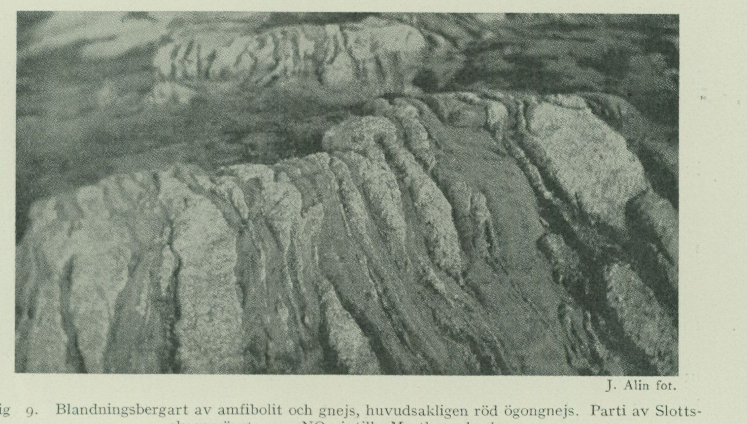
Bedrock
—bolitic development, separated by an intermediate zone, within which the rock appears more or less strongly mixed with gneissic interlayers, the latter of which petrographically and geologically could to some extent be conceived as a continuation of the aforementioned thicker interlayer developed on Hisingen. These petrographic variations within the greenstone layer are particularly well displayed in the rock mass immediately around Masthuggskyrkan (fig. 9). The more westerly main part of the layer is here developed as a coarse-grained hornblende-plagioclase rock of a peculiar structure, reminiscent of certain forms
J. Alin, photograph.
Fig. 9. Mixed rock of amphibolite and gneiss, mainly red augen gneiss. Part of the Slottsskogen greenstone NE adjacent to Masthuggskyrkan.
of hyperites or coarse-crystalline augite-plagioclase rock portions occasionally occurring in such rocks. Farther toward S within the Slottsskogen area, this rock type is replaced by a fine-grained and diabase-like noritic pyroxene greenstone of the same character as the rock at Glöstorp and, like the latter, accompanied by more acidic modifications with segregations of blue quartz grains. Also in the gradually narrowing continuation of the greenstone belt farther toward S, a fundamentally similar structural pattern is observed, with noritic rock portions developed at intervals along the western side of the zone. In the as yet only cursorily examined larger swellings of the layer in the vicinity of Kungsbacka, the noritic rock type appears to be replaced by a similar but even more diabase-like rock modification, which closely agrees with the so-called hyperitic greenstones occurring farther east within the map area and, like these, contains only monoclinic augitic pyroxene as the pyroxene mineral.
E adjacent to the Slottsskogen greenstone, there finally begins the zone of red alkaline gneisses, which stands out very sharply within the gneiss formation of the Göteborg area and which forms the bedrock within a considerable part of the western portion of Göteborg’s built-up urban area as well as within several of the
most dominant rock masses in the city’s immediate surroundings, and which for these reasons may be considered, among the various rock members of the formation, best deserving of the local name “Göteborg gneiss.”
As already briefly stated in the petrographic overview, the alkaline type of red gneisses that is specifically characteristic of the gneiss zone in question is distinguished primarily by a very calcic-feldspar-poor composition and simultaneously rather low quartz content but a comparatively considerable content of soda feldspar. With these main chemical-mineralogical characteristics is combined a series of other petrographic distinctive features, which moreover appear rather generally to characterize granite and gneiss rocks of a corresponding composition. The feldspar minerals in the alkaline gneisses — both the plagioclase¹ and the potash feldspar — thus generally exhibit an abundant iron oxide pigmentation, owing to which these gneisses are mostly distinguished by a vivid red color, which however in many cases appears only on a somewhat weathered or sun-exposed surface, whereas the color tone in a fresh fracture may be more pale reddish grey. A content of fluorite is fairly regularly present and often already macroscopically apparent; microscopically there is additionally observed a comparatively high content of zircon. The iron-magnesia-bearing constituents in these gneisses are represented by intensely colored iron-oxide-rich mineral varieties, whereby the biotite is often accompanied or entirely replaced by a green iron hornblende. Certain extremely calcic-feldspar-poor gneiss varieties within the rock zone have, upon microscopic examination, proved to contain blue-colored amphibole and green pyroxene minerals, belonging to those pronouncedly soda- and iron-rich varieties within these mineral groups known under the names of arfvedsonite and aegirine-augite respectively, which otherwise in their natural occurrence tend to be limited to certain special alkali rock formations and elsewhere have scarcely been observed in any Swedish Precambrian gneiss. Such arfvedsonite gneisses are noted both in the area immediately S of Göteborg, e.g., in a zone ca. 300 m E of Finsmossen, and at Grimbo in Tuve parish, but their extent otherwise has not yet been sufficiently investigated. As characteristic of the alkaline gneisses of the Göteborg zone may finally be emphasized a certain brittleness in the rocks and an apparently related pronounced susceptibility to weathering. In many of the rock masses that are built up of gneisses of this type, the rock is in places decomposed by weathering down to a depth of as much as 3 m into a loose gravel, which in many places has been utilized as road gravel. The more noteworthy occurrences of such residual gravel, most of which are indicated with a special designation on the combined rock and soil map, are the following: S and SE of Finsmossen in Fässbergs parish, S and SE of Grimbo in Tuve parish, SE of Asmundtorp and E of Svensby in Säve parish. The susceptibility to weathering appears most pronounced within certain zones of even- and sharp-crystalline gneiss varieties within the rock zone, which here at the same time also ap—
¹ In contrast to the condition in many other gneisses and granites of corresponding chemical character, the plagioclase in the alkaline gneisses of the Göteborg area occurs only to a minor extent in so-called perthitic intergrowth with the potash feldspar but instead forms independent crystals.
represent the most plagioclase-poor and most »alkaline» types within it. No fully satisfactory explanation of this weathering susceptibility, which appears in certain rock types even within many other more alkaline rock areas, seems to have been found thus far. In association with the more typical alkaline gneisses, there also occur, especially along the western side of the rock zone, lighter and more potassium-feldspar-rich and at the same time often muscovite-bearing rock modifications, which in many places, for example SE of Majornas folkskola, are accompanied by minor bands of almost feldspar-free quartz-muscovite schist as well as almost purely quartzitic rock portions. Among other rocks occurring within the Göteborg gneiss belt, special mention should be made of a rather isolated occurrence in the eastern part of Ramberget near Göteborg of a very coarse augen gneiss with the potassium feldspar segregated into »eye crystals» of usually 5 to 6 cm in diameter. In structure, the Ramberget augen gneiss most closely corresponds to the rocks in the eastern augen gneiss belt of the map area, while its composition appears to approach somewhat that of the Lundby augen gneisses. No petrographically fully corresponding rock has been observed anywhere within the remaining parts of the Göteborg gneiss’s area of distribution, but the continuation of the Ramberget rock is probably to be sought on the southern side of Göta älv in a belt, appearing here within the typical red alkaline gneisses, of coarser and somewhat augen-structured rock forms. In several places but mainly within an apparently continuous belt near the eastern boundary of the rock zone, the red gneisses are seen to occur in repeated alternation with minor bands and streaks of dark feldspar-poor amphibolite, which locally, as SE of Grimbo, appear to accumulate into more compact portions of a somewhat hyperitic greenstone. Apparently separated from the main belt by a loop of grey gneisses intruding from the S, there occurs between Backa kyrka and Kungälv a parallel belt about 2 km wide of petrographically corresponding alkaline rocks, which, however, further to the N outside the map boundary probably connects directly with the main belt and is with all certainty to be understood only as a part of the main belt’s bottom layer folded down into the underlying grey gneisses. In accordance with such an interpretation, the rocks immediately on the southwestern side of this parallel belt show decidedly easterly dips, in striking contrast to the otherwise very consistent westerly dips prevailing within the section of the gneiss formation in question. The rock is farthest S, in the area nearest Backa and Hökällan, of a hornblende-rich completely massive type but assumes further to the N the typical appearance of the alkaline gneisses of the Göteborg belt. In the rock mass immediately N of Bäckebol, a fairly considerable body of a partly pyroxene- and garnet-bearing rather coarse greenstone type occurs within the gneiss.
IV. Grey gneisses and augen gneiss in the eastern part of the map area. The easternmost part of the map area is occupied by a petrographically rather uniform division of grey gneisses with a sharply prominent horizon of a coarse augen gneiss within it. In contrast to conditions within the rock belts described above, this division occupies a predominantly flat-lying attitude, and
the augen gneiss appears to form a shallowly anticlinally dipping intercalation in the grey gneiss. The same facies of the iron gneiss appears subsequently to continue towards S and E as the prevailing type over a wide area in northern Halland and southwestern Västergötland all the way to the vicinity of Borås. The grey gneisses prevailing within this eastern division of the iron gneiss formation of the Göteborg area are petrographically characterized by a very even-crystalline, typically »iron gneiss-grained» structure with generally well-developed layering or banding and a detail-level somewhat streaky alternation of lighter and darker rock portions. In their mineralogical composition, these gneisses vary (cf. p. 22) mainly between a lime-rich, in places hornblende-bearing, pure plagioclase gneiss and a microcline-rich, generally lighter and on weathered surfaces somewhat reddish type, which however in the field offer such indistinct distinguishing features that the entire series has for practical reasons had to be mapped under one and the same designation. Of other rock types occurring in association with the eastern grey gneisses, mention should be made — besides the aforementioned augen gneiss — of certain intercalations of greenstones, two-mica gneisses, and red fine-grained gneisses, which however are generally of minor thickness and can only with difficulty be followed in reliable continuity over longer distances. Within the part of the area nearest Göteborg, the more detailedly investigated part, the structure within the division is broadly as follows. Immediately adjacent to the red alkaline gneisses, a boundary zone of certain potassium-feldspar-bearing grey or partly more intermediate gneisses is regularly encountered, which in places, as within the city of Göteborg, appear to pass rather imperceptibly into the adjacent red alkaline gneisses. In the hills N of Sahlgrenska sjukhuset as well as N of Tolltorp, these transition beds appear through folding to attain a more considerable thickness and assume thereby within the latter area locally the development of a kind of augen gneiss with larger crystals of vivid red potassium feldspar sparsely scattered in a dark grey gneiss mass. In the next following more typical grey gneisses, a fairly thickly swelling belt of strongly streaky and contorted, two-mica and usually somewhat potassium-feldspar-bearing gneisses (»Backa gneiss») is noted in the southeasternmost part of Hisingen, as well as some minor amphibolite intercalations, which in the hills on both sides of Gibraltar locally swell out into a couple of comparatively considerable masses of a more or less gabbro-dioritic greenstone. Within the beds of the grey gneiss formation appearing immediately E thereof on the western side of Mölndalsån and continuing northward on the eastern side of Göta älv, the rocks appear to be characterized by a strongly streaky development with intermixed red potassium-feldspar-rich lenses and band-streaks or minor bands of red fine-grained gneiss. The section following to the E thereof is characterized especially by a belt of certain lumpy greenstone portions, occurring in rows or swarms within the grey gneisses here present, of an often completely diabase-like development, which
appear, both in geological and petrographic respects, to offer many analogies with the hyperite occurrences characteristic of the more eastern parts of the iron gneiss area. The first impression of these, from several viewpoints interesting, rock formations is in many cases undoubtedly that they belong to dike zones of younger diabase rocks transecting the gneiss formation; a closer investigation of the mode of occurrence reveals, however, with all clarity that the greenstone occurrences in question are to be understood as portions of a geologically uniform greenstone zone conformably incorporated in the gneiss formation, of the same nature as the previously described, more westerly occurring dioritic and noritic greenstone belts, albeit with a detail-wise discontinuous, almost fragmentary mode of development. In its principal course, this greenstone belt has been traceable from the northern map boundary to the southern. Within the best exposed section, in the area between Rösered and Kviberg, the individual lumps arrange themselves in a strongly elongated fold alignment trending toward S or SSW, here forming a distinct tectonic parallel to the foldings of the alkaline red gneiss and eastern augen gneiss, respectively, appearing on both sides thereof (cf. Pl. 2 in “Göteborgstraktens geologi”). In some places, such as in the area of Örgryte and Kallebäck, the hyperitic greenstone lumps exhibit a more irregular swarming distribution, which may be assumed to be conditioned by the more complicated crumpling present here within the surrounding gneiss layers. The width of the individual greenstone portions within the “lump belt” varies from insignificance up to over 100 m and is mostly around 5 to 10 m. In contrast to the area’s true diabases, the hyperitic rocks in question are very resistant to erosion and generally rise as hills or ridges above the surrounding gneiss. The largest occurrence within the belt forms, as a lenticular or ellipsoidal body enclosed on all sides by gneiss, the summit of Gärdsås kulle, a rocky massif situated about 2 km NNE of Kviberg, rising steeply from the surrounding terrain, which from a morphological viewpoint might well be compared with the well-known Värmland hyperite mountains (fig. 10). Other more marked occurrences belonging here crop out on the crest of the steep Överåsberget near Örgryte kyrka as well as in the rocky hill projecting isolated from Gullbergsvassen, on which the skansen Lejonet is built. The contacts of the hyperitic greenstone portions mostly appear very sharp. No true contact densification can be observed anywhere, however; instead, the massive rock portions are often surrounded by amphibolitic border zones, and along certain stretches of the belt the hyperitic rock forms appear to be entirely replaced by more layer-like extended amphibolite portions, which in no way deviate from other amphibolite intercalations occurring within the gneiss formation. In cases where the greenstone inclusions are of a more rounded form, the gneiss’s parallel structure mostly exhibits a concentric orientation around the greenstone, a relationship that would most likely be considered indicative of the latter rock having existed in solid form already before the crystallization of the surrounding gneiss. Closest to the larger greenstone occurrences—
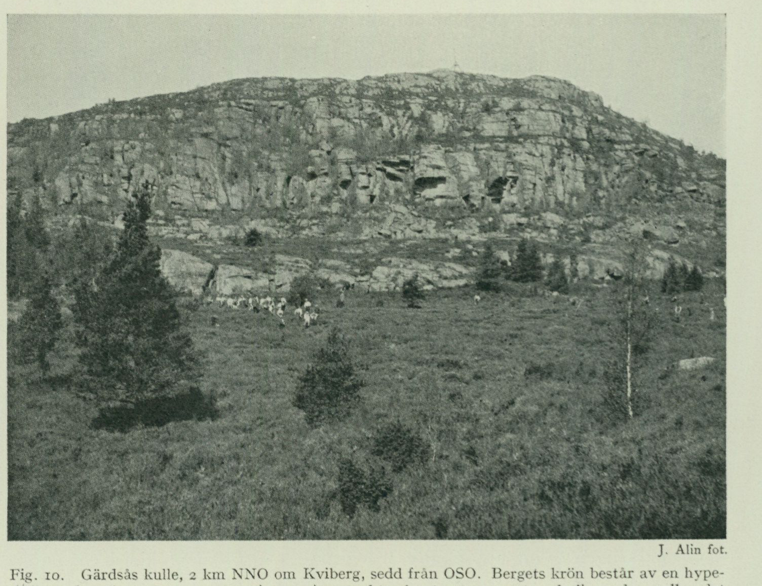
—or in the intervening sections between nearby greenstone lumps, a tendency toward pegmatitic development in the gneiss is often observed. Furthermore, the hyperitic rock portions are accompanied in many places, especially in the belt’s “hanging wall,” by thinner banks of more reddish and microcline-rich gneiss, while the gneisses adjoining in the “footwall” tend to be of darker and hornblende-bearing type. In their most hyperite-like developmental forms, the greenstones in question have the character of augite-plagioclase rocks of almost entirely black colour and a structure consistent with medium-grained diabases. The pyroxene mineral constitutes — as far as has been investigated so far — an iron-oxide-rich augite with small axial angle, so-called hypersthene augite, of the same character that typically distinguishes many forms of olivine-free diabases. More common, however, are certain lighter-variegated “hyperite-dioritic” rock forms of a partly coarser structure, in which the pyroxene mineral is wholly or predominantly replaced by green hornblende, often with an admixture of colourless iron-magnesia amphibole (cummingtonite). At some localities within the northern part of the belt, rock varieties with a partly labrador-porphyritic structure also occur. All the rocks furthermore carry a more or less considerable content of garnet. Judging from the mineralogical composition, these hyperitic greenstones appear in general to be characterized by a
J. Alin, photograph.
Fig. 10. Gärdsås kulle, 2 km NNE of Kviberg, seen from ESE. The summit of the mountain consists of a hyperite-like greenstone, which by its massive structure contrasts with the underlying regularly stratified and jointed grey gneiss.
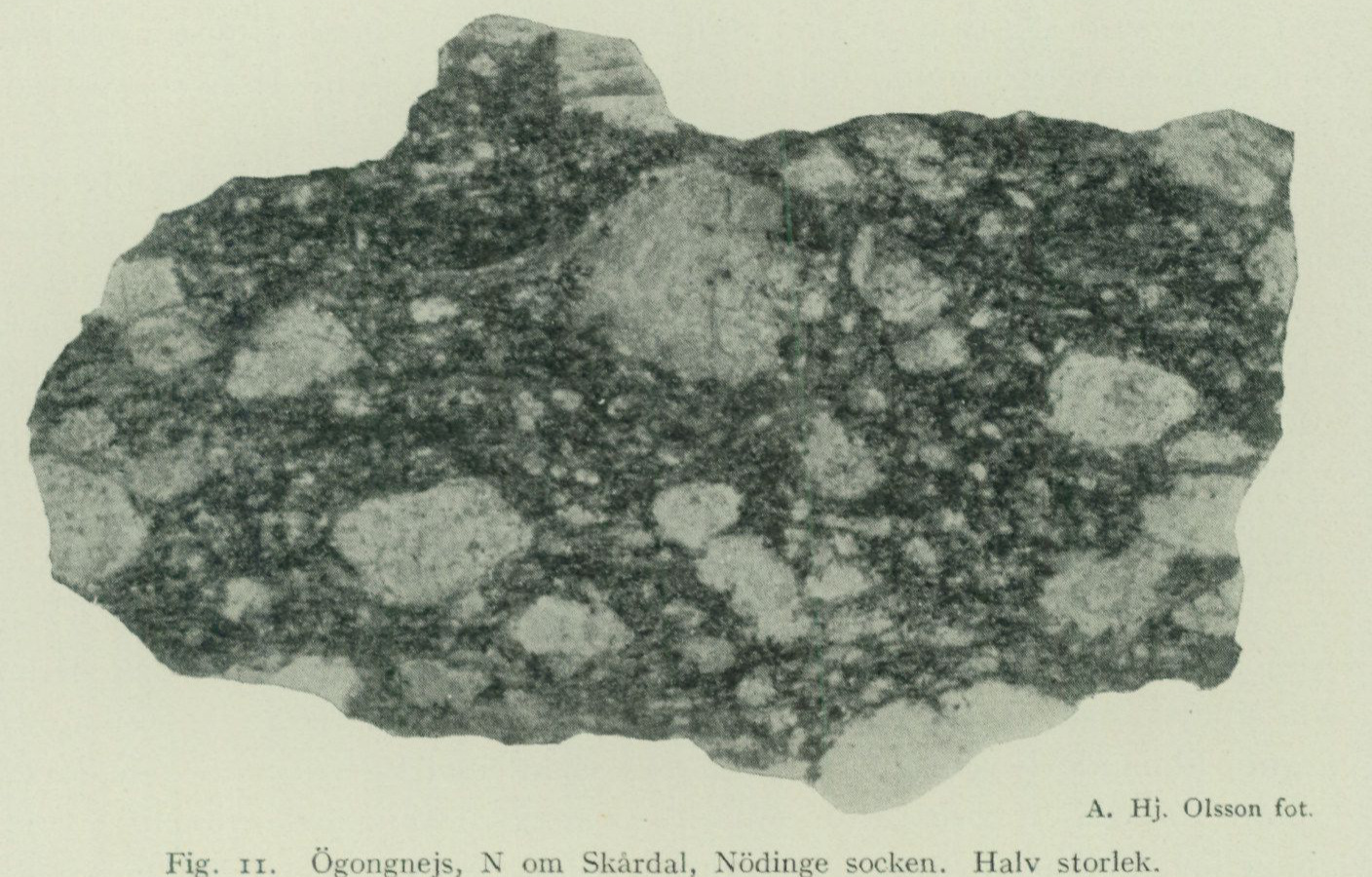
a comparatively iron-oxide-rich composition and should, from a petrographic-systematic point of view, be regarded as a special type of gabbroid greenstones, which is closely related to the norites but differs through an even more iron-oxide-rich composition and a consequently even more clearly pronounced tendency toward diabase-like structural development.
At some distance in the hanging wall of this hyperitic greenstone zone, the aforementioned so-called “eastern augen gneiss” then crops out. The rock is everywhere easily recognizable due to its coarse texture, with potassium feldspar
A. Hj. Olsson, photograph.
Fig. 11. Augen gneiss, N of Skårdal, Nödinge parish. Half size.
separated into usually 4 to 6 cm large rounded or somewhat rectangular augen crystals, densely strewn in a dark grey-gneissose groundmass (fig. 11).1 Despite the coarse structural development, a distinct stratification generally appears in the rock mass. Through the disappearance of the augen crystals, the rock rapidly transitions into the surrounding grey gneiss; on the other hand, transitions to potassium-feldspar-richer, more reddish-streaked and banded gneiss varieties are often observed. As illustrated in more detail by plate 2 in “Göteborgstraktens geologi”, the gneiss zone in question has, upon more systematic field tracing, proved to form an entirely closed buckling loop, which in a practically unbroken continuity could be followed within the area east of map sheet Göteborg from the Kungälv area farthest in the N to Sjärsjön S of Landvetter, with a total length of about 10 Swedish miles.12 The occurrence of such a closed rock contour is of interest as constituting a tangible expression of the regularity
 1 The augen gneiss zone in question appears to constitute the parent fissure for the augen gneiss that is often observed as larger boulders in the area nearest Göteborg.
 2 The strike of the layer in the area immediately on the northern side of lake Aspen is somewhat incorrectly indicated on the said map about 1 km too far towards the E. Within the portion northwards from Angereds kyrka, the layer narrows rapidly and pinches out completely over a short distance.
of the layered structural style prevailing within the gneiss formation of the area. Along the entire southern and western side of the augen gneiss loop, the attitude is distinctly anticlinal with gently outward-dipping attitudes, whereas along the northeastern side an overturning of the layers towards the E appears to prevail. The width of the augen gneiss band generally amounts to a few hundred m. On the sides, it is locally bounded by minor bands of a rather characteristic black-and-white-mottled greenstone, which locally, for example at Kvastekulla in Partille, swells into small masses of a coarse hypersthene-bearing gabbro rock. Also within the layer, minor greenstone banks are encountered in several places, such as E of Mellby in Partille, which readily display the same diabase-like development as the hyperitic greenstones just described.
The augen gneiss rocks occurring along the eastern side of the map sheet, in the terrain E and SE of Göteborg city, belong to an almost entirely pinched-off loop-like bulge of the augen gneiss layer, which from the area W of Angereds kyrka is drawn out towards S all the way down to Rådasjön. Within the southern part of the area enclosed by this augen gneiss loop, such as in the area immediately around Delsjöarna, the rock appears, probably as a result of folding together with the immediately adjacent gneiss layers, to repeat itself in a series of more or less persistent parallel bands. The augen gneiss is here accompanied in the hanging wall by a zone of light-red, often muscovite-bearing, fine-grained gneisses, which can be followed as an easily recognizable band from the area S of Delsjöarna past Kärralund, Utby and Betala up to Angered. To this red gneiss is connected a closely related type of somewhat more calcareous and grey-gneiss-like rocks (cf. p. 21), which with almost horizontal attitude occupy an extensive area in the centre of the augen gneiss loop in the area between Vidkärr and L:a Delsjön. Judging by the remnants of former quarrying that remain in virtually the entire area of distribution of the rock, gneisses of this intermediate petrographic type appear to have been specifically sought for paving-stone production and probably constitute the only one of the many gneiss varieties of the Göteborg area that could be utilized for such a purpose to any appreciable extent.
Mode of formation of the gneiss formation.
The Archaean gneiss terrains present so many distinctive features deviating from those of later geological formations that no reliable and more generally accepted view of the original formation conditions of these formations can be considered to have been attained even approximately at present. To this must be added that, of these extensive terrains, only very insignificant portions have yet been subjected to more detailed investigations. To attempt to provide any more comprehensive account of the various interpretation hypotheses that have been proposed for these formations and more or less directly applied also to the iron gneiss formation of western Sweden, lies outside the scope of this description, and only a few viewpoints that emerge
position taken in earlier mapping work within the iron gneiss area, and which appears to have been further brought to the fore by the results of the special mapping carried out in the Göteborg area.
From the account given above of the petrographic character of the gneiss rocks, it is evident that the gneiss formation of the Göteborg area, like the iron gneiss formation in general, is almost entirely composed of rock types whose chemical and mineralogical composition offer very close equivalents to types of granitic, syenitic, and greenstone-like rocks commonly occurring within younger eruptive rock formations. In those rocks of a more massive structure, which in many places within the iron gneiss area occur as local developmental forms of the ordinary iron gneiss types and the greenstone bands interbedded with them, the petrographic correspondence with chemically equivalent younger intrusive rocks is fairly complete. This correspondence applies not only to the individual chemical types; the very pattern of variation in chemical terms that characterizes the iron gneiss formation, and which in its broadest outlines may be considered illustrated by the diagram fig. 8, is found in its main features within many younger eruptive rock series and is to be regarded as typical of such rock series as have originated through so-called magmatic differentiation.
If this comparison is extended also to the geological mode of occurrence of the rocks, however, fundamentally essential differences emerge. The intrusive rocks occurring in younger formations generally exhibit a geological mode of occurrence that clearly shows that these rocks intruded successively and made their way from deeper-lying magma hearths. Within the iron gneiss formation, on the other hand, the different petrographic rock members have, upon closer examination, invariably proved to occur as conformably alternating, often in relation to their extent very thin beds of a regularity that in many cases may well be compared with the bedding within sedimentary formations. This pronounced stratified mode of emplacement shows that the various differentiation members here did not intrude separately and successively into one another but must be thought to have formed in situ through a stratified separation, proceeding according to certain definite chemical laws, within a very large magma mass of originally more uniform composition.
In accordance with such a view, a more detailed investigation of the structure of the iron gneiss formation provides much evidence that the different petrographic members here are not arbitrarily mixed together, but in their distribution exhibit certain chemical regularities and in many cases clearly appear, so to speak, to be chemically conditioned by one another. As an example, only the mode of occurrence of the more significant greenstone horizons appearing within the gneiss formation of the Göteborg area may be pointed out here. Of these, the westernmost, the “Frölunda greenstone,” is situated at the boundary between two chemically clearly distinct rock zones, the more plagioclase-rich “Frölunda gneiss” and the more potassium feldspar-rich “Askim gneiss”;
where the surrounding rock zones completely pinch out in the northerly field direction and are replaced by more purely plagioclase-gneissic rock forms, the Frölunda greenstone also ceases and is replaced by unstable intermediate rocks. The next succeeding greenstone zone is similarly bound to the boundary between the western plagioclase gneisses and the more alkaline gneiss division, rich in potassium feldspar, extending to the east thereof. The large Slottskog greenstone is clearly linked to the red alkaline gneiss accompanying it on the eastern side. A corresponding phenomenon appears, albeit with less sharp petrographic contrast between the rocks, in the regular association between the potassium feldspar-rich “Ryanabb gneiss” beds occurring within the grey plagioclase gneisses of Hisingen and certain basic hornblende gneiss zones, and so forth. A similar occurrence of greenstone-like rock zones adjacent to the boundary of more potassium feldspar-rich red gneiss tracts is, moreover, generally observed also in other parts of the iron gneiss area. Within the Göteborg area, the rule seems to repeat itself such that the potassium feldspar-rich iron gneiss beds are situated immediately on the eastern side of the basic horizons — according to the general dip relations apparently underlying the latter — on account of which a certain periodic regularity in the distribution of the principal chemical types within the series makes itself felt.
With the circumstances pointed out above, it has here only been possible to touch in passing upon some of the many petrographic and geological questions of interest that present themselves upon a closer study of the iron gneiss formation of western Sweden, but regarding which more certain foundations may be expected only insofar as the formation has been mapped in its context over larger areas and its relations to surrounding areas of the basement rocks have been more closely investigated.
Pegmatites.
Pegmatitic rocks are encountered preferentially within two separate areas of the Göteborg district, namely partly in certain tracts of the archipelago’s streaky two-mica gneisses, and partly within a bedrock portion belonging mainly to the eastern grey gneiss area, which extends over the city of Göteborg itself and the area immediately to the E and SE thereof. In the remaining parts of the map area, such formations on the other hand appear to occur rather sporadically or are altogether absent.
The pegmatites occurring in the coastal zone appear on the whole to be geologically and genetically closely connected with the surrounding gneisses and occur in them as more indistinctly delimited beds or lens-shaped masses. The structure is not coarse. The colour of the potassium feldspar is white or faintly reddish, and like the surrounding gneiss, the pegmatite is also usually richly muscovite-bearing.
In contrast to this, the pegmatites within the more easterly area form a system of sharply separated veins, which with a main direction approximately WNW—ESE cut across the various rock members of the gneiss formation. The potassium feldspar is
belonging dikes of red color, the quartz usually dark smoky, the content of dark minerals low and muscovite is absent. Although the structure in these dikes is often quite coarse, pegmatite of such development that feldspar quarrying could have occurred, albeit on a small scale, has only been found at one locality within the map area. The occurrence in question is located in the rock about 400 m NW of Bjurslätt in Lundby parish (slightly NW of the stone cairn indicated here on the bedrock and Quaternary map) and appears to form an about 40 m long and 5 m wide lens-shaped swelling within a smaller dike swarm of pegmatite, which in the usual WNW direction cuts through the red alkaline gneiss cropping out here. Peculiar to this occurrence is that the potash feldspar occurs developed as beautifully colored green ‘amazonstone’.
Older diabases.
In connection with the mapping of the gneiss formation of the Gothenburg area, a not insignificant number of dikes sharply cutting the gneiss bedrock of more or less typical diabase character have been found, which, as already emphasized in the introduction, are distributed into two distinctly different-aged dike systems. The rocks designated here as ‘older diabases’ form a system of generally narrow — rarely over 1 to 2 m and often only a few dm wide — but readily swarm-grouped dikes of a somewhat radiating but mainly NNE—SSW direction and steep western dip. In their main mass, these dike rocks usually have the appearance of fine-grained diabases of green-black, in the surface often vivid green color and distinct ‘list structure’, more rarely also with a somewhat porphyritic development. However, pyroxene-bearing forms of typical diabase composition are nowhere observed, but the rocks carry, as ferromagnesian mineral component, always only green hornblende alongside abundant brown mica. Almost everywhere at these dikes, the rock within a narrower zone closest to the selvages is developed as a biotite-rich, distinctly schistose and partly quite coarse-grained mica-amphibolite or rather biotite schist, whereby sometimes the intervening massive rock through more gently dipping planes of schistosity appears to be divided into somewhat obliquely placed rhombohedral parts relative to the selvages. Narrower dikes, or those pinched off in more lens-shaped parts, often exhibit an amphibolitic development throughout the entire dike mass; such dike amphibolites are, however, mostly already petrographically easy to distinguish from such forms of mica-amphibolites that geologically belong to the surrounding gneiss formation. Judging from all appearances, the schistosity phenomena in question, exclusively bound to the dikes themselves, are to be understood as having originated in fairly immediate connection to the original crystallization of the dike rocks and constitute sequel phenomena to the formation of the dike fracture system itself. Dikes belonging to this older system are known from the following localities: 1) A swarm of parallel dikes in the northern part of Björkö in Öckerö parish (here first observed by J. Alin) along with several, although less distinctly prominent dikes further south on the island.
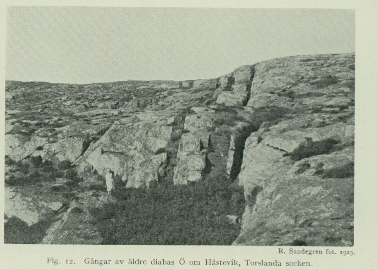
- Numerous dikes on the Torslanda peninsula in the area SE of Hästevik (fig. 12), and a magnificently prominent dike swarm — with often only dm- wide gneiss ribs between the individual dikes — on Porsholmen S thereof.1 These dikes appear to converge towards the SW with a dense dike swarm of a more ENE direction, appearing on the island Skäddan S thereof and subsequently also on the southern tip of the Torslanda peninsula, which is continued by scattered dikes on the headlands and islands further to the NE.
Fig. 12. Dikes of older diabase E of Hästevik, Torslanda parish
R. Sandegren, photograph, 1923.
- Some scattered and discontinuously developed dike strikes on the south side of Hisingen in the area of Härröd and Stampered etc., with an isolated outlier in the area NW of Bräcke.
- A swarm of parallel dikes on the northern headland of Rivön in Styrsö parish (according to communication from J. Alin). Perhaps upon more systematic searching, other occurrences can also be demonstrated within the coastal belt. Since the massive fine-grained dike portions are intensely fractured and also the schistose selvage rocks easily detach from the side rock, the rock in these dikes is usually completely eroded away at the surface, leaving marked crevices in the bedrock, while solid outcropping rock is accessible for observation preferably in the higher bedrock ridges and in the washed-clean cliffs right along the seashore. Although for these reasons it must be considered possible that any dikes located further from the coast have been completely overlooked, it nevertheless appears, due to the
1 The dikes are clearly distinguishable from the steamboat route outside the island.
From the distribution of the known dikes it is certain that these “older diabases” within the Gothenburg area are principally confined to a rather narrow belt of bedrock extending along the coast itself in a NNW direction. Continuing farther north along the coast of Bohuslän, apparently quite similar, swarming dikes are known from Hermanön and nearby islands on the map sheet “Uddevalla” as well as on the Kosteröarna within the map sheet “Strömstad”, and still farther north, dikes of presumably the same type have been observed on certain islands in Oslofjorden. Regarding the time of formation of this dike system, it can only be stated that the dikes of this group within the Gothenburg area sharply cut across the various gneisses of the coastal zone as well as the group of pegmatites associated with these gneisses, but are in turn cut by the younger diabase dikes described below; since these latter may themselves be of Precambrian age, an age determination as Precambrian can be maintained with even greater justification in the case of the dikes of the older system. According to A. Gavelin, the aforementioned analogous dikes on Koster are cut by certain pegmatites, which may be assumed to be connected with the Bohusgraniten, and thus the dikes there may even be older than the mentioned granite massif, which is nevertheless generally regarded as a typical Precambrian granite.
Younger diabases.
The dike system designated here as “younger diabases” comprises a number of rather thick and apparently very persistent, vertically standing dikes, which traverse the area in a distinctly WNW–ESE direction, cutting approximately at right angles across the aforementioned older dike system. In these younger dikes too, the tendency to “weather out” is evident, owing to which the course of the dikes is in stretches marked in the terrain by pronounced valley troughs. Petrographically, the younger diabases mostly belong to a plagioclase-rich type of olivine diabases of comparatively coarse texture and rather light, grey-green colour. Microscopically, more or less thorough alteration within the mineral assemblage is often observed, with formation of hornblende and epidote minerals, etc. — The dikes belonging to this group are, from N to S, the following. The Tuve dike. This dike is distinguished by its considerable width, reaching approximately 100 m, and a correspondingly coarse texture, which remains almost unchanged all the way to the dike’s selvage. Immediately adjacent to the contacts, a reaction or assimilation zone about 1/2 m wide within the wall rock is regularly observed, the latter still bearing traces of contact effects at several metres’ distance from the boundary in the form of a more or less strong reddening. The dike can be followed in numerous exposures from the area just W of Tuve kyrka out to the point NW of Nolvik and here forms a clear continuation of the diabase occurrences at Höga on the north side of Älvefjorden, already indicated on the 1st edition of the geological map sheet “Göteborg”. From Höga, the diabase dike continues across Gräsholmarna, Koholmen, Gillhol-
men, Vandholmen, Särholmen and a small island located W of the latter, but is here out in the archipelago much narrower than at Höga. Quite narrow parallel dikes occur N and E of Höga as well as on Trollö. Particularly in the area N of Nolvik, the soil formed atop the diabase gives rise to a luxuriant meadow vegetation contrasting clearly with the surroundings. A continuation of the dike on the eastern side of Kvillebäcksdalen is indicated on the bedrock map on account of a marked valley trough running here ESE from Hökälla in the dike direction, in the southern steep side of which an insignificant exposure of diabase is present about 450 m N of Skår in Backa parish. The Grimbo dike. The dike in question is marked by a trough in the bedrock terrain that is easily followed from the area just N of Grimbo towards Östergärde. The diabase exposed therein at a couple of localities is about 20 m wide with tight selvages, without assimilation contacts. Farther west, the dike may be presumed to continue in the brook valley up to the road junction SE of Björlanda kyrka, for just SW of the church a 10 to 12 m wide rock cleft begins, trending WNW, which in its eastern part is filled with till material, but in the W shows diabase in its bottom. In the low shore outcrops W of here, the diabase dike has a width of a couple of metres, but pinches out before reaching the water’s edge. In the eastern, till-filled part of the rock cleft, on the northern steep wall, here and there clings a thin flake of the diabase selvage remaining attached to the wall rock, which consists of a fine-grained grey plagioclase gneiss. On the eastern side of Kvillebäcken, the dike appears with a width of 10 to 13 m in several exposures in the heights around Tingstad on both sides of Backavägen. In the easternmost part, the dike abruptly turns toward NE and is finally seen in a few outcrops just east of the road to Bältskär to finger out into a network of small dikes. Adjacent to these eastern exposures of the dike, the wall rock is sometimes mylonitically indurated and the diabase itself somewhat amphibolitically schistose, and in the aforementioned small dikes at the dike’s termination, within the dense diabase, patches of a garnet-bearing biotite schist rock modification are encountered. The Slottsskogen dike. The first exposure of this diabase dike was encountered in Slottsskogen near Göteborg in the form of a selvage flake of diabase remaining attached to a rock wall of augen gneiss, which appears near the road past “Säldammen”, at the southern edge of the marked transverse valley extending here. The continuation of the dike is exposed along the southern edge of Godhemsberget, NW of Slottsskogen, and subsequently on Hisingen along the southern side of the topographically sharply pronounced valley trough that extends past Ardal through Synneredsviken and across Höstholmen. Still farther W, out on Torslandahalvön, the dike is well exposed in the western part of the marked weathering trough that has been utilized for the alignment of the new main road between Amhult and Hästevik, and here a local cross-cutting of the older system’s dikes can also be directly observed. In the area of Hästevik, the dike appears to bend into a more northwesterly direction and is found again on Björkö, where it can be followed across the island somewhat S of Skar- vik. Finally, the dike has been found on Hälsö, both at the lighthouse and on the northern
part of the island, where it has a direction of N 50° W and can be followed to the innermost end of the bay projecting from the NW between Hälsö and Stuvö. The width amounts to about 25 m on Hälsö and Björkö but seems to gradually decrease towards the E and is only about 12 m in the part exposed in Godhemsberget; at several places, smaller parallel dykes are also observed alongside the main dyke. In the easternmost part, the dyke fissure probably merges with and disappears into the large fracture and crushing zone of Tolltorpsdalen; as a possible continuation of the diabase, a section of a completely mylonitized dense greenstone, the original nature of which cannot now be safely determined, may be mentioned here, appearing in the scarp at the mouth of the valley immediately SE of Sahlgrenska sjukhuset. Furthermore, in several places within the outer parts of the map area, narrow straight fracture fissures in the bedrock can be observed with a direction parallel to the dyke system in question. As a noteworthy feature concerning these diabase dykes, it may finally be emphasized that in no case has any continuation of the dykes on the eastern side of Götaälvsdalen and its natural continuation towards the S down to Kungsbackaviken been encountered, a circumstance which probably indicates that the land on the western side of the aforementioned very marked fracture line already existed at the time of the origin of the WNW dyke system as a block separated from the inland. As already emphasized in the introduction, no reliable determination of the geological age of these “younger diabases” can currently be achieved. In their petrographic character, these undoubtedly correspond most closely to the Central Swedish Precambrian diabases of the “Jotnian” type. On the other hand, the striking agreement in mode of occurrence and direction with the “Konga-diabases” of Skåne could be argued to suggest a younger, post-Silurian age. In the northernmost parts of Bohuslän, the definitely post-Silurian diabases are represented by the well-known rock dyke, which is petrographically highly divergent from the younger diabases of the Göteborg area, partly developed as a rhomb porphyry of a more syenitic composition, which here could be followed along the coast all the way down to the southern part of the map sheet “Uddevalla”.
Crushing zones in the bedrock.
The more marked valleys in the area are sculpted along fracture lines in the bedrock, next to which, in certain cases, distinct crushing and alteration phenomena can be observed in the immediately surrounding rocks. These crushing phenomena are most pronounced along Tolltorpsdalen, running S of Göteborg down towards Fässberg, along which the gneisses within a zone about 100 to 150 m wide show themselves to be heavily fractured and partly crushed down into hälleflinta-like mylonitic dense rocks. As previously mentioned, the Slottsskog diabase may perhaps also have been affected by the same mylonitization process here. The continuation of this mylonite belt can then be followed towards the N along the rock edge between Sahlgrenska sjukhuset and Annedalskyrkan and also appears further up in a
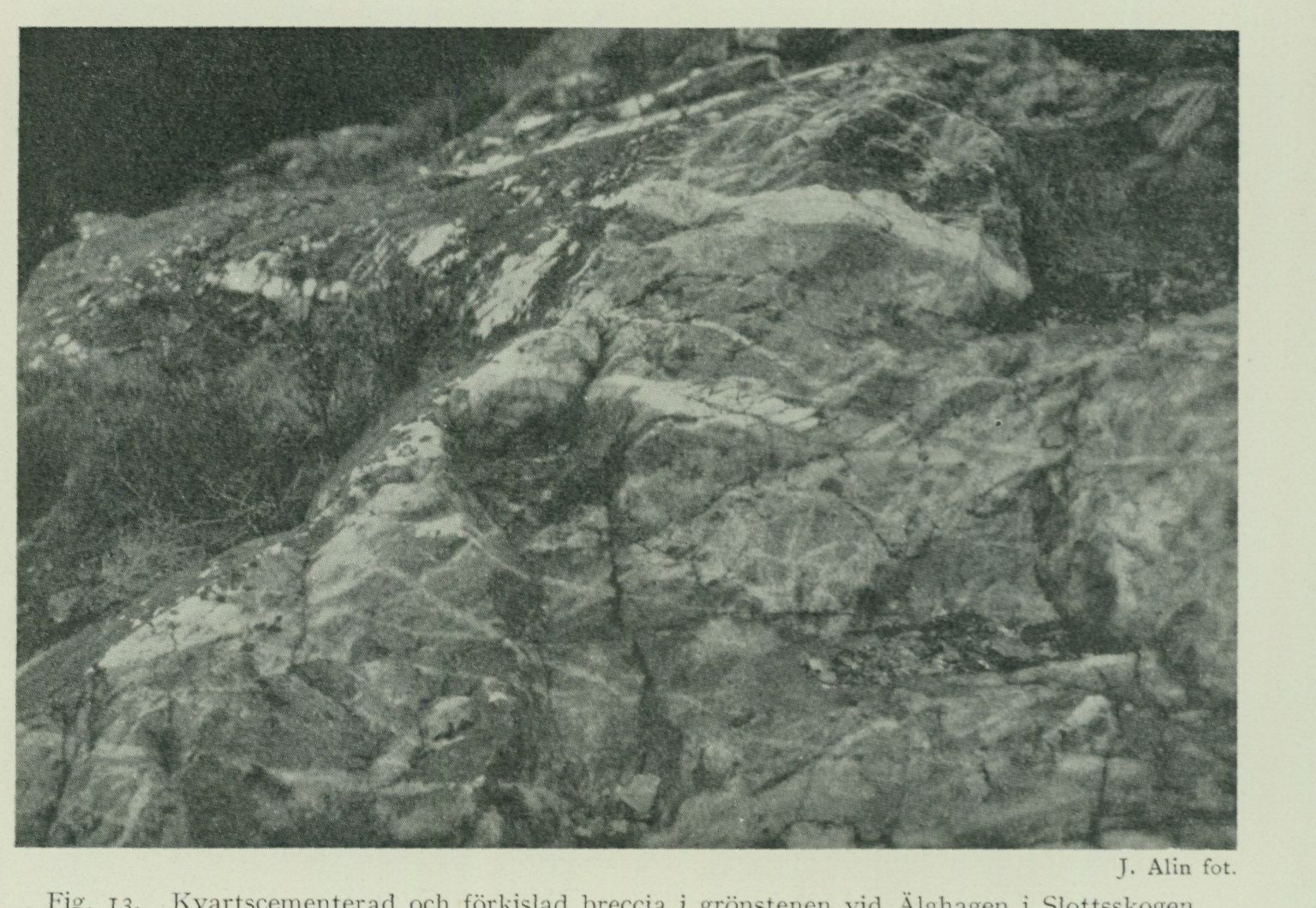
rock outcrop by Linnégatan immediately W of skansen Kronan, the rock of which in its entirety bears several traces of mylonitic influence. In the continuation of the same fracture zone along Kvillebäcksdalen on Hisingen, a certain fracturing with an accompanying reddening of the rocks appears, especially in the grey gneisses on the eastern side. True mylonites and crushing breccias are observed W of Lillhagen, S of Tuve hållplats and S of Trollered. N of here, the crushing zone continues in the valley towards the N past Djupadal up to Nordre älv. Beautiful
J. Alin, photograph.
Fig. 13. Quartz-cemented and pyritized breccia in the greenstone at Älghagen in Slottsskogen.
mylonites and breccias are thus found SE of Lid and N of Elleröd in Rödbo parish. Along the entire stretch from here along Nordre älv up to Kungälv, the gneisses show clear traces of secondary influence, manifesting itself in a partly very intense reddening of the local plagioclase gneisses during a simultaneous “exudation” of quartz segregations in the rock, whereas actual crushing phenomena are barely noticeable. Along the Götaälvsdalen itself and its continuation southwards, the crushing phenomena are far less noticeable. The circumstance is probably partly due to the fact that the more central parts of the fracture zone here are generally not available for observation, but even next to the narrow parts of the valley in the vicinity of Kållered, essentially only a certain fracturing of the rocks and a related tendency to the formation of talus slopes along the valley sides are perceived. Finally, a couple of dyke zones of a pyritized breccia, appearing in Slottsskogen near Göteborg, may be mentioned here, pro-
ceeding in an E–W direction, of which one passes over the rock ridge W of Ålderdomshemmet, the other slightly S thereof near “Älghagen”. The dyke mass consists of fragments of mylonitized country rock — alkaline gneiss or Slottsskog greenstone — which have been cemented by quartz and thereby simultaneously undergone a more or less complete pyritization (fig. 13). The formations in question are genetically certainly closely associated with the Slottsskog diabase, running a little further to the S, which latter, moreover, in the part of the dyke exposed further to the W near Godhemsberget can be seen to be directly accompanied by border zones of similar pyritized mylonite breccia.
The Quaternary Deposits (Quaternary System).
By R. Sandegren.
The unconsolidated deposits occurring within the map-sheet area belong to the youngest geological system, the Quaternary system, and were formed partly during the Ice Age and partly during the subsequent postglacial period, which extends right up to the present day. Accordingly, the deposits may be classified as follows:
Glacial deposits.
Till deposits, consisting of unsorted mixtures of stone, gravel, sand, and clay, directly deposited by the inland ice. Glaciofluvial deposits, consisting of rounded boulders, gravel, and sand, deposited by glacial rivers during the melting of the inland ice. Late-glacial marine deposits, consisting of gravel, sand, clay, and shell gravel, deposited in the sea in front of the ice margin.
Postglacial deposits.
Postglacial marine deposits, consisting of gravel, sand, clay, saltwater gyttja, and shell gravel, deposited in the postglacial sea (the Yoldia Sea). Postglacial supramarine deposits, which were deposited on land or in bodies of fresh water as the late-glacial sea and the Yoldia Sea, respectively, gradually retreated. These deposits consist partly of mechanical sediments, which include flood deposits (sand and clay deposited along the banks of watercourses or at river mouths as deltas) and wind-blown sand, and partly of biogenic deposits: freshwater gyttja and peat, formed through the accumulation of dead animal and plant remains.
Glacial deposits.
As already mentioned in the introduction, the details of the topography within the map-sheet area originate from the Ice Age, in that the advancing ice masses then excavated valleys along zones of weakness present in the bedrock, rounded and polished the rock surfaces, and to a certain extent filled depressions in the bedrock with till gravel. Before proceeding to the description of the Quaternary deposits belonging to the glacial deposits, however, it may be appropriate to give an account of certain phenomena that arose during the Ice Age, namely striations and giant’s kettles.
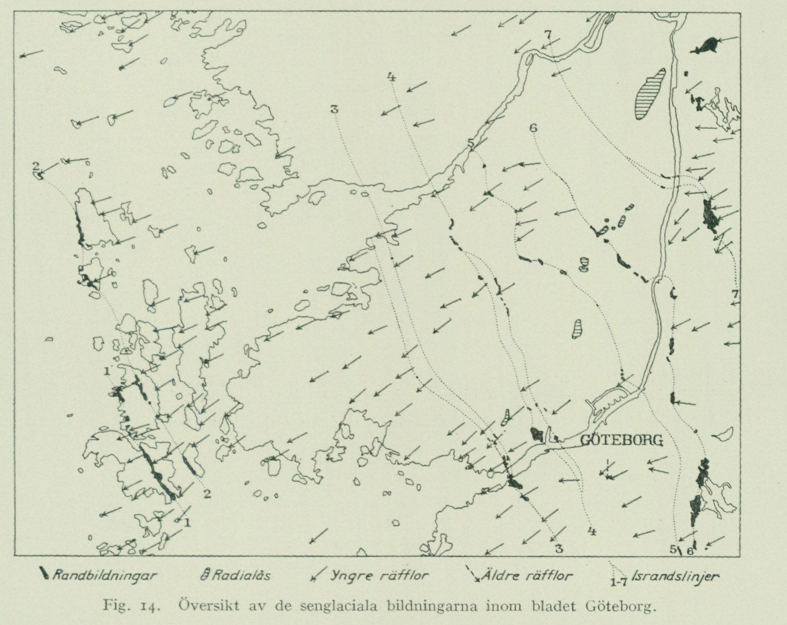
Striations.
The striations incised in the rock surfaces indicate the direction in which the ice mass moved forward at each individual point, immediately before ice abrasion ceased there. However, striations with different directions can sometimes occur on the same rock surface, so-called crossing striations. This phenomenon is caused by the ice having changed its direction of movement, and the abrasion after the change of direction at the point in question having been so slight that the older striations were not completely obliterated. With the aid of the relative sharpness and overall development of the differently directed striations, one can determine which direction of movement is older and which is younger. Of 242 striation observations within the entire Göteborg map sheet, 214 fall between N 40° E and N 78° E, and of these, 178 fall between N 50° E and N 70° E. The most common striation direction (48 observations) is from N 65° E. The ice thus moved here, during the final phase of glaciation, essentially from ENE toward WSW, which is also evident from the direction of the ice-marginal lines (fig. 14). The directional variations indicated by the aforementioned striation observations are, in most cases, explained by the topographic conditions, in that the ice mass, during its advance, was partly forced to follow marked valley tracts and partly had to deflect to either side of steeply rising heights.
However, in the easternmost part of the map-sheet area, E of the large north–south-trending valley occupied by Göta älv and Mölndalsån, striations (21 observations) occur, varying between N 80° E and S 75° E, i.e. with an essentially east–west direction. These striations were probably incised in connection with the ice-marginal oscillations during which the prominent marginal deposits occurring here were laid down. Finally, mention should be made of those striations that originate from earlier phases of the glaciation than that during which the final melting-away of the ice took place. Foremost among these are four observations of very faintly visible or almost obliterated striations from the area of the city of Göteborg. They have been found only on rock surfaces that lay comparatively sheltered from the later stripping, which, moreover, largely obliterated the older stoss and lee sides of the rock outcrops. On rock surfaces in the bottom of the gravel pit at Carnegieska bruket (NE of Nya Varvet), older striations from N 46° W and N 24° W thus occur (alongside younger striations averaging N 60° E); S of Masthuggskyrkan, due north–south striations have been found, and at Sahlgrenska sjukhuset, striations from N 2° E. These striations probably originate from an earlier phase of the Ice Age, when Kattegatt was still filled with ice and movement was mainly directed from north to south. During this earlier phase, deep glacial erosion in the valleys likely acted mainly within the north–south-trending valley tracts, whereas erosion during the final phase of glaciation acted mostly in valleys with a northeast–southwest direction. Lastly, three observations of striations with directions between N 30° E and N 35° E may be mentioned. One of these, from a rock surface 100 m SE of Hultet (N of Eriksbo in Angereds parish), is of some interest. The rock surface displays crossing striations, the older ones with the aforementioned direction, the younger ones from N 55° E. The latter probably date from the time of the ice-margin advance during which the Röseredsplatån was deposited (see below p. 73), while the older ones stem from a phase prior to this oscillation.
Giant’s kettles.
The glacial rivers flowing forward beneath the land ice exerted powerful erosion within their channels and, to a great extent, washed away any till gravel that may previously have been present there. But glaciofluvial erosion also attacked the bedrock itself, whereby smoothly rounded, channel-shaped or bowl-shaped hollows were sculpted in the rock surfaces (fig. 15). Among the erosion forms produced by glacial rivers, however, the so-called giant’s kettles attract the most attention. These are considered to have formed in such a way that meltwater streams running on the surface of the ice cover plunged down through crevasses in the ice. In doing so, the violently swirling, downward-plunging mass of water, with the aid of smaller boulders, stones, and gravel, reamed out more or less cylindrical, usually vertical cavities of varying dimensions in the rock. The occurrence of giant’s kettles also on highly situated rock areas supports their origin in the manner indicated, and at a time when the ice still lay
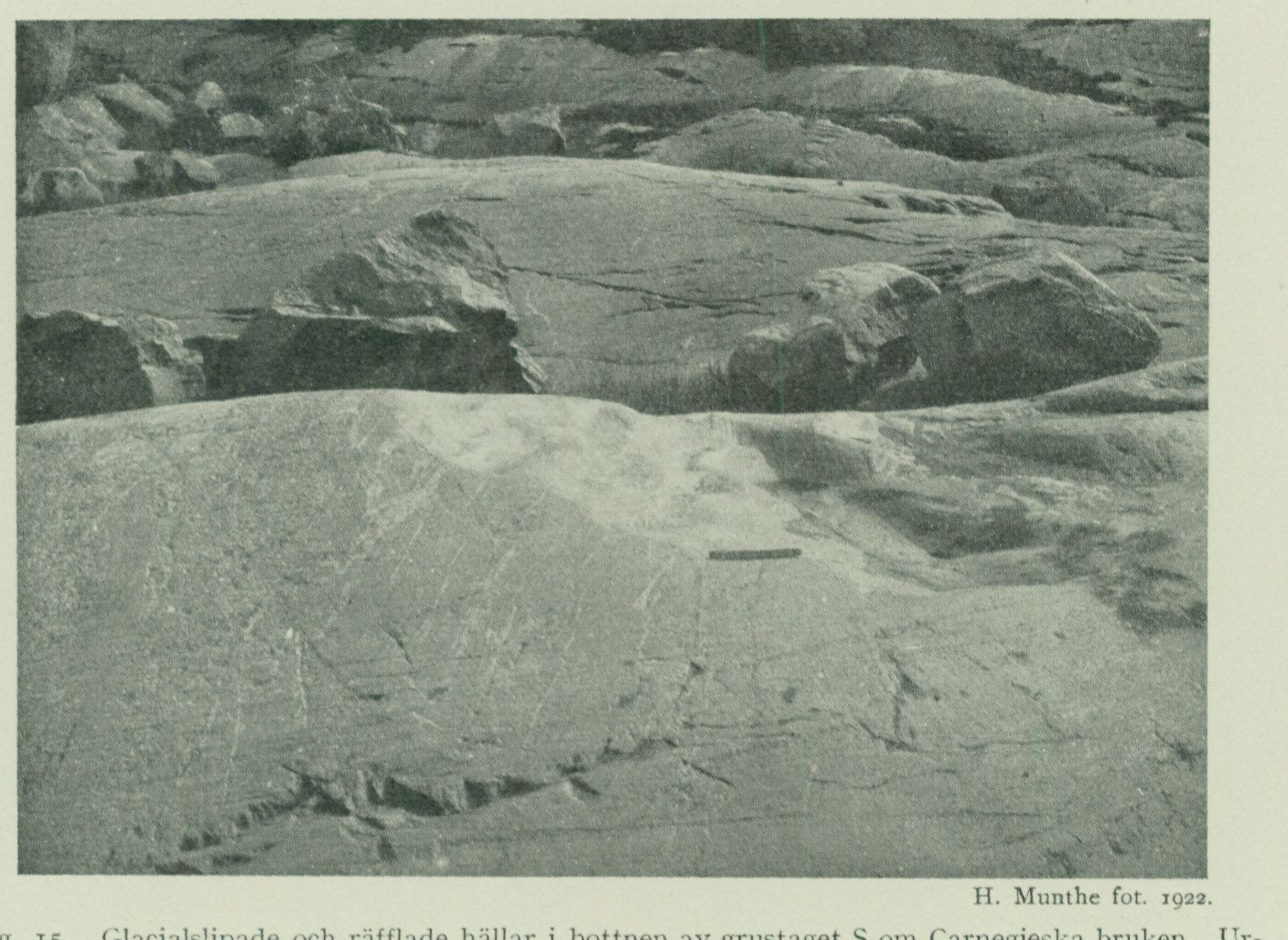
remaining over the area. This mode of explanation is further supported especially by the circumstance that the giant potholes often occur in groups, preferably in places where the terrain shows steep and marked differences in elevation. In such places, the conditions were indeed greatest for the formation of those crevices and fissures in the moving ice sheet, through which the meltwater streams could plunge down. Examples of this condition are provided by several giant-pothole areas on the Göteborg map sheet, such as those in the vicinity of Örgryte
H. Munthe, photograph, 1922.
Fig. 15. Glacially polished and striated bedrock surfaces in the bottom of the gravel pit S of Carnegie works. The hollows (the light area on the nearest rock surface) originated through glacial-river erosion.
old church, in Slottsskogen, at Färjenäs etc. Such giant potholes developed in steep rock walls usually have, in their upper part, the character of an open, semicircular niche, while the lower part constitutes a cylindrical pot. From these glacial giant potholes, which owing to their mode of formation are called glacial-river potholes, one must distinguish those usually channel- or trough-shaped scourings that have formed on more or less strongly sloping rock surfaces, through the action of breakers on the seashore rolling often quite large boulders back and forth. These latter, so-called shore potholes, are common within the archipelago area and generally occur only below the highest marine limit. The prerequisite for the formation of shore potholes is presumably small crevice fissures more or less perpendicular to the shore, where the boulders were held in place and could, over a longer period, be rolled back and forth by the breakers. Within the Göteborg map sheet, the following giant potholes were encountered during the geological fieldwork:
Öckerö parish:
A group of 12 potholes in the southern slope of the rock NNW of Bovik on Björkö. Most are small and niche-shaped; the largest measures ca. 1 m in diameter.
Torslanda parish:
A small pothole within the large high rock complex ca. 1.5 km W of Amhult, 0.35 m deep and 0.35 m in diameter. A group of 4 small potholes in the precipitous northern side of Tumlehedsdalen ca. 1 km NW of the church. Three of the potholes are niche-shaped; the fourth is double, in the sense that two potholes formed close together have, through continued scouring, merged into an oval pothole. This one is 0.3 m deep and 0.35 x 0.25 m in diameter.
Västra Frölunda parish: Some smaller niche-shaped scourings in a rock wall NNE of Tranereds station.
Björlanda parish: Three small niche-shaped scourings in the western side of a steep rock wall ca. 700 m W of L. Rödjan. A beautiful oval pothole in the shore cliff N of the bay NW of Fågelvik on a gently N-sloping rock surface. The diameter in N—S 1.2 m, in W—E 1 m. The depth at least 0.8 m; the pothole was not cleaned out. A group of 4 potholes W of the church not far from the shore. Three of them are niche-shaped. The largest 2 m deep measured from the highest rim and 1 m in diameter. The others measure 75 (this one is not niche-shaped), 65, and 50 cm in diameter and were not cleaned out.
Torsby parish: A large oval pothole on the western part of Brunskär, 3 x 2.3 m in diameter, according to an unverified report “2 fathoms” deep. Above the pothole proper there is a ca. 5 m high niche-shaped section. The pothole was formerly used as a water reservoir. A multitude of smaller potholes and scourings occur around the large one. Two groups of giant potholes occur SE of Glöskär. The western group consists of a multitude of potholes of varying size; the largest of these is oval, 2.2 x 1.8 m in diameter, earth-filled. The eastern group displays several fine potholes, the largest 2.15 m in diameter and 1.8 and 4 m deep from the respective lowest and highest rims. A pothole on a rock ledge 500 m E of St. Röd, somewhat more than 2 m deep and ca. 1 m in diameter. Above the pothole there is a nearly 2 m high niche-shaped section. Two small potholes ca. 500 m S of the church, ca. 0.7 m deep and ca. 0.5 m in diameter.
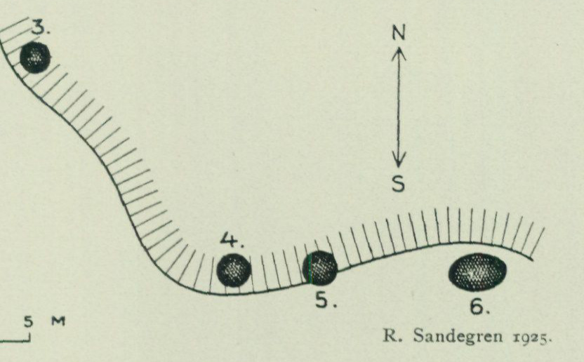
Two potholes immediately adjacent to the cottage ca. 700 m SW of Staby. One is ca. 4 m deep and 1.2 m in diameter and is used as a well; the other has roughly the same diameter as the first but is very shallow. A small pothole and some scourings ca. 700 m WSW of Dotorp.
Lycke parish: Numerous small niche-shaped scourings at the easternmost point of St. Rovet. A group of 6 potholes on the eastern part of L. Vanholmen. The relative positions of the potholes are shown in fig. 16. The dimensions are as follows (regarding the
R. Sandegren, photograph, 1925.
Fig. 16. Group of giant potholes on L. Vanholmen in Lycke parish
numbering, see fig. 16): No. 1 is 0.4 m in diameter and 30 and 45 cm deep from the respective lowest and highest rims. No. 2 is 35 cm in diameter and 20 and 35 cm deep from the respective lowest and highest rims. Both are situated in gently sloping rock surface and have an almost perfectly circular opening; they were earth-filled but were cleaned out during measurement. No. 3 is situated in a strongly sloping rock edge, 0.5—0.6 m in diameter and 40 and 80 cm deep from the respective lowest and highest rims. It was filled with water, earth, and stones but was cleaned out during measurement. No. 4 is also situated in a strongly sloping rock edge, 35—45 cm in diameter and 30 and 60 cm deep from the respective lowest and highest rims; it had previously been cleaned out. No. 5 is situated in an almost vertical rock face and is therefore niche-shaped in its upper part. Below this there follows a round pothole, which measures 45 cm in diameter at the mouth but widens slightly downward. The depth at least 0.7 m from the mouth of the pothole proper; not cleaned out. No. 6 is oval, with diameters of 1.5 m in W—E and 0.9 m in N—S, not cleaned out.
Göteborg city: Three niche-shaped potholes in a steep rock wall adjacent to Renhagen in Slottsskogen. The uppermost of these is ca. 2.5 m high and ca. 2.4 m in diameter; the middle one is ca. 1.8 m high and ca. 1 m in diameter; the lowermost is quite small. The two upper niches, the appearance of which is shown in fig. 17, have pot-shaped continuations in their bottoms, the depth of which is however unknown, since they are filled with sand.
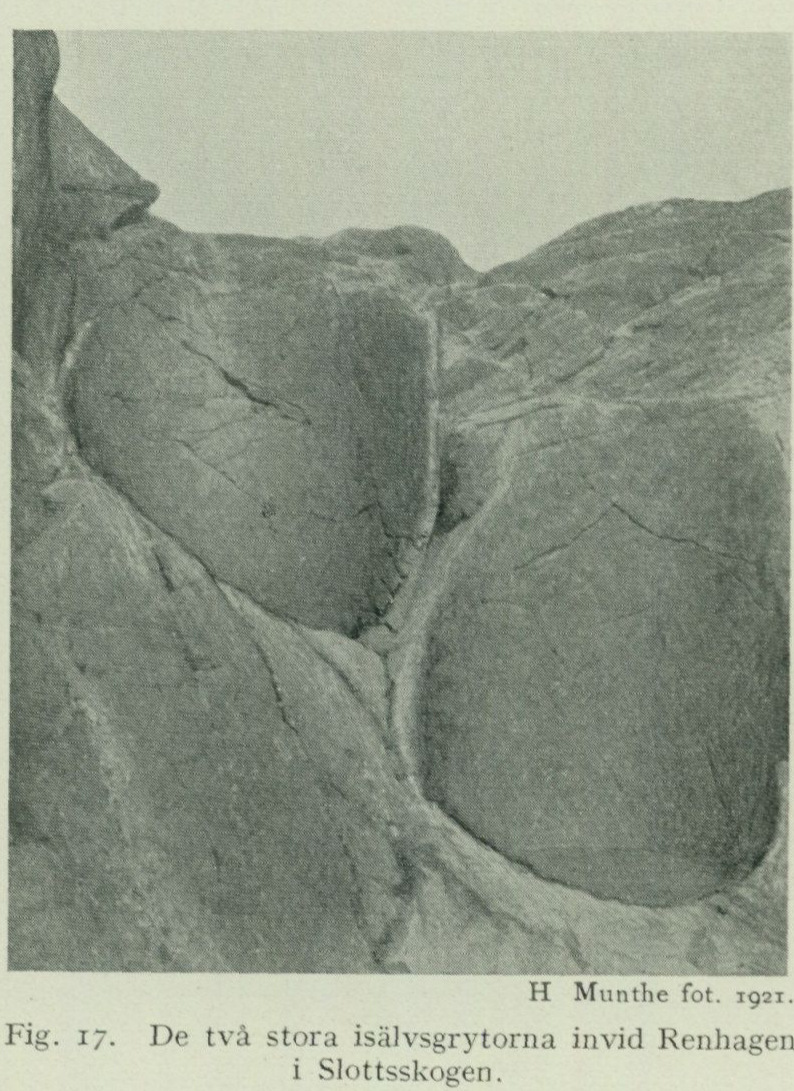
Other niche-shaped scour-hollows are also found in Slottsskogen, namely some smaller ones E of the first-mentioned ones and some in the rock face immediately E of Säldammen.
Lundby parish:
Two niche-shaped scour-hollows in the western steep side of the small rock c. 300 m NE of Rya nabb. Five small beautiful kettles E adjacent to the road c. 500 m NNW of the ferry landing at Färjenäs. They are scoured in the steep southern side of a rock surface, three larger in one group and 2 smaller in one. The three larger have the following dimensions: the largest is 1 m deep and 0.4—0.5 m in dia meter, the second 0.8 m deep at the northern and 0.2 m at the southern edge and 0.5 m in diameter, the third is 1 m deep at the northern and 0.2 m at the southern edge and 0.45 m in diame ter. The two remaining kettles are, as mentioned, smaller. H. Munthe, photograph, 1921.
Fig. 17. The two large glacial-river potholes beside Renhagen in Slottsskogen.
East of those just mentioned, on the southern face of the large rock outcrop in the grounds of one of the larger so-called landshövdingehus apartment buildings, there are a considerable number of kettle-like scour hollows. Most have unfortunately been destroyed by blasting. One of the least damaged niches is 0.8 m deep and 0.75 m in diameter. A kettle on the top of the mountain c. 100 m S of Pölsebo 0.4 m deep and 0.25 m in diameter. A shallow, kettle-like scour-hollow in a Wward-dipping rock surface near the top of the mountain 400 m SSW of Lundby new church. A kettle adjacent to the road bend c. 1,400 m NNE of Bräcke, 0.6—0.7 m in diameter, not cleared out, for which reason the depth is unknown.
Säve parish:
Two kettles at Öxnäs at a distance of c. 1 m from each other. The western is 0.7 m in diameter and 0.7 and 1 m deep from the lowest and highest edges respectively. The eastern is 0.7 m in diameter and 0.35 and 1.6 m deep from the lowest and highest edges respectively (fig. 18).
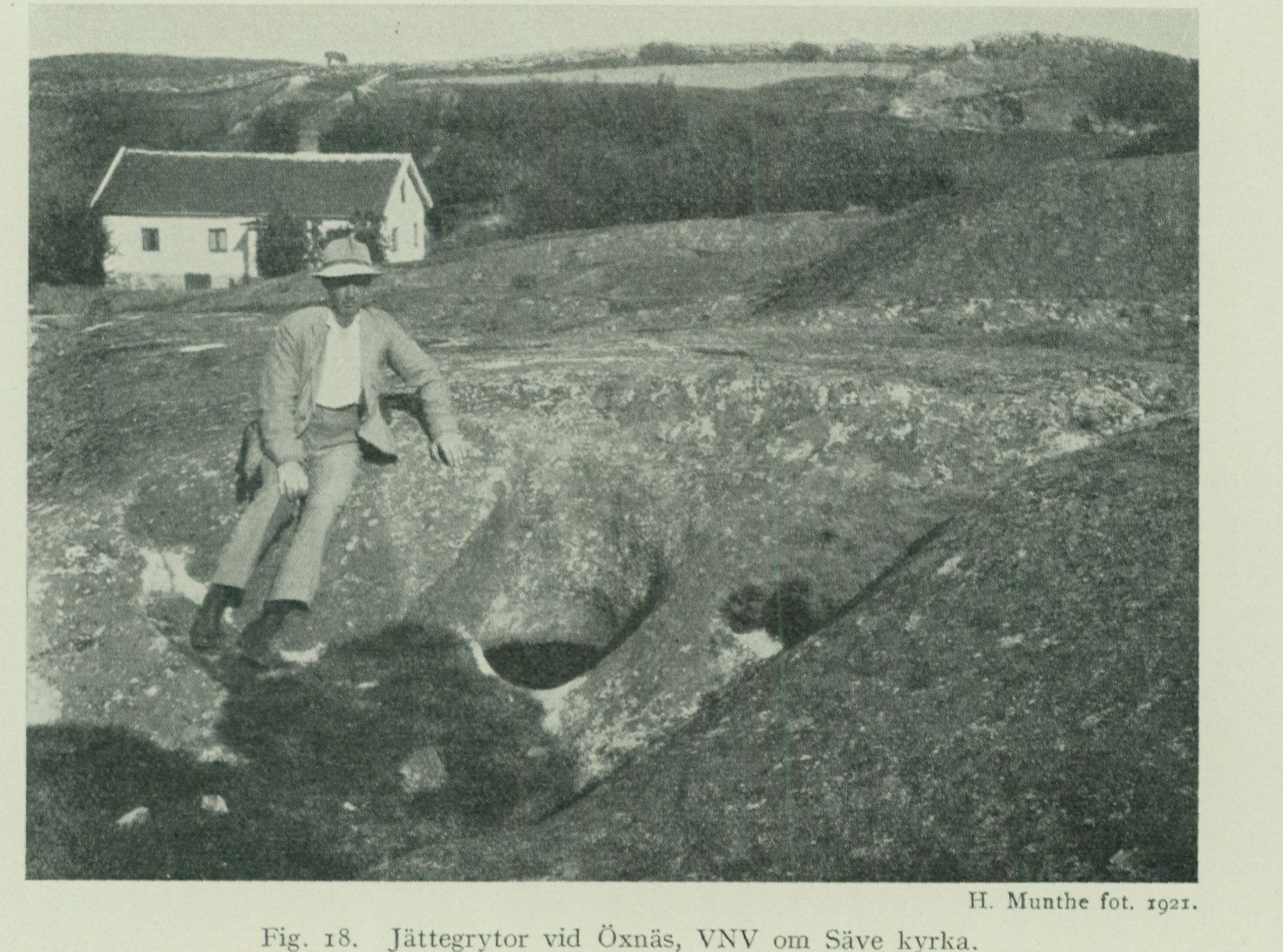
Two kettles at Brunstorp. One lies in a Wward-dipping rock face. Below a 1.5 m high niche-shaped part the kettle itself begins, in uncleared condition 3 m deep and 1.3 m in diameter. The other lies in a Sward-facing rock face and consists of a 2.3 m high niche, 2.3 m in diameter. At the bottom of the niche only a faint incipient kettle is visible. A kettle W of Näset in a rock surface adjacent to Nordre älv.
H. Munthe, photograph, 1921. Fig. 18. Giant potholes at Öxnäs, WNW of Säve church.
Fässbergs parish: A kettle c. 250 m N of the northern end of lake Långvattnet, 0.25 m deep and 0.5 m in diameter.
Örgryte parish: A group of 4 kettles together with the incipient beginning of a fifth in the nearly vertical Wward-facing rock face c. 400 m S of Örgryte gamla kyrka. Three of the kettles, which are partly niche-shaped, have diameters between 1.4 and 2.5 m, while the fourth is smaller. The largest kettle-niche is c. 4.5 m high, but as the kettles have not been cleared out, their total depth is unknown. The last- mentioned large kettle is connected by means of a “window” with the nearby kettle. If the scouring had continued further, these two would thus eventually have merged into a giant kettle. A group of 5 kettles in a Wward-dipping rock surface c. 200 m S of Örgryte gamla kyrka. These are likewise partly niche-shaped. Three of the kettles
     have diameters of about 1 m, while the other two are smaller.  The largest
       pot's niche-shaped part is about 2 m high, another "whole" pot is about
         1.4 m deep.
    Angered parish:
     An earth-filled pot in the southern edge of a rock surface NW of Rösered, about
      2 m in diameter.
      Two niche-shaped scourings adjacent to one another in a vertical rock wall E of
      Forsbäck, 1.5 to 1.8 m in diameter.
        Several niche-shaped scourings also occur at S. Surte, 1 to 1.5 m in
      diameter.
    Nödinge parish:
     A pot near the brook from Surtesjön, 2.4 m in diameter.
Till deposits.
Among the soil layers, the till deposits are the oldest, and these therefore rest, as a general rule, directly on the bedrock. In places, however, till is encountered on or between other soil layers, primarily marine sediments, a depositional relationship that arose during such, usually minor, advances as the margin of the land ice was sometimes subjected to during the ice’s general retreat in late-glacial time.
Till gravel. The till consists of material that the land ice, during its advancing movement, broke loose from its solid substrate and dragged along with it. The greatest part of this material was presumably transported forward beneath the ice mass itself or in its lowermost layers. This so-called basal till (in everyday language sometimes called “pinnmo”) consists, in its typical development, of a hard-packed, irregular mixture of more or less worn and striated, uneven and angular stones and boulders, embedded in a gravelly, sandy, or clayey groundmass. It is usually unstratified and then exhibits no sorting by different grain sizes. Within the Göteborg sheet, the till is generally gravelly, owing to the fact that it has almost exclusively been formed at the expense of hard crystalline bedrock types. But in those cases where the till, during advances of the ice margin, has incorporated sandy marine sediments, with which it—as indicated above—sometimes is interbedded, it is predominantly sandy, although it additionally contains gravel and boulders. Sometimes till that, during such an advance of the ice margin, has so to speak been dumped down a slope on the sea floor, may exhibit a certain, if indistinct, stratification or bedding indicative of its deposition in the sea, and may give the material a certain resemblance to glaciofluvial gravel (cf. below regarding the depositional relationships in the end moraine at Olskroken). A smaller part of the till material was transported embedded in the upper layers of the ice. This material was deposited on top of the basal till during the ice’s melting and is of looser composition and of lesser thickness than the latter. Within the Göteborg sheet, this so-called supraglacial till presumably does not play any role, if one disregards the so-called erratics lying loosely on the ground surface. In many cases, e.g., when large erratics lie on otherwise bare bedrock below
the highest marine limit, these too presumably mark remnants of ordinary basal till or of end-moraine ridges, whose finer material has been completely washed away by wave action. Apart from the more or less complete reworking into wash gravel and beach gravel that the till has undergone at all sites strongly exposed to wave action during earlier land-uplift stages, it is, in its outermost parts, always more or less altered by weathering and the loosening brought about by vegetation and other organisms. Its color, which deeper down is as a rule grayish, is at the top most often yellowish or brownish, depending on the degree of oxidation of the included iron compounds. As is apparent from the map, only very small areas of till crop out within the present area. Apart from certain zones where till gravel has accumulated in the form of end-moraine formations, such material appears mainly only as fill in narrow valleys and other depressions. Thus, till is generally absent on the rock heights, a circumstance that, regarding the areas below the highest marine limit, can partly be explained by the till here having been successively washed away by waves during various stages of shoreline displacement. But since till is also rare on those parts of the bedrock that lie above the marine limit, and here usually occurs only patchwise as a quite thin cover mainly in crevices between till-free rounded rock surfaces, it is evident that the land ice generally did not leave behind any noteworthy till on the heights, but rather accumulated it chiefly in the deeper depressions. Till thus certainly forms the nearest substrate for the younger sand and clay sediments that occupy the area’s larger valleys and low-lying plains. However, it appears as though the land ice, during the final phase of glaciation within the areas in question here, carried relatively insignificant quantities of till material compared with what was the case in several other parts of our country. Otherwise one might have expected that at least the deep rift valleys oriented perpendicular to the direction of ice movement would have been considerably more filled with till gravel than is the case.
It is thus a characteristic feature of the area that a continuous End moraines till cover is absent, and that the till, where it occurs patchwise, is generally exceedingly thin. However, till accumulations occur here and there, appearing either as long, narrow ridges prominent in the topography, or as more lobe-shaped swellings, within which latter the till gravel can sometimes reach a fairly considerable thickness. These formations are so-called end moraines or terminal moraines and have formed through accumulation and shoving-forward of till material along the ice margin, when the latter, during the land ice’s deglaciation phase, was for a time stationary or made a more or less extensive readvance over an area previously freed from ice. The end moraines occurring within the sheet, together with certain glaciofluvial deposits, are arranged into a series of ice-marginal lines, each marking the position of the ice margin during a certain phase of the land ice’s recession (see below p. 74—76).
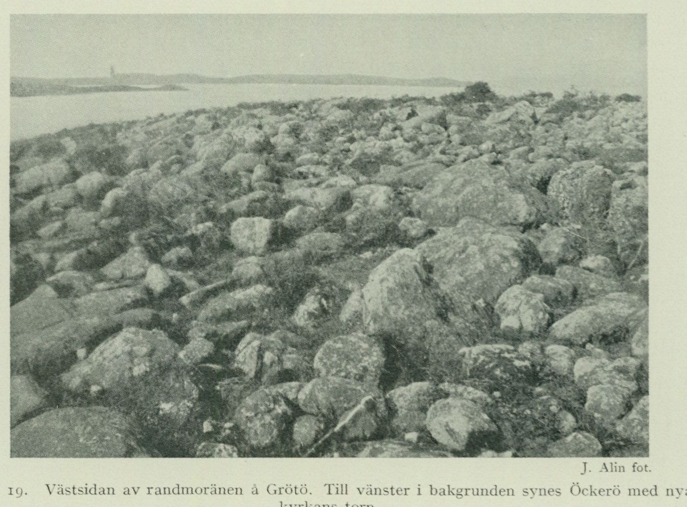
The end moraines of the area exhibit essentially three visually quite different types. The end moraines occurring in the archipelago on Hönö, Grötö, Öckerö, Hyppln and Rörö usually take the form of low ridges about one or a few hundred metres in width. The surface material consists of masses of coarse shingle and large boulders, washed clean and partly also reworked by the action of breakers. Through the abrasion to which most stones were subjected during the time the moraines lay within the surf zone, they have acquired a more
J. Alin, photograph. Fig. 19. Western side of the end moraine on Grötö. To the left in the background Öckerö can be seen with the tower of the new church.
or less rounded form. These end moraines are therefore almost entirely devoid of any higher vegetation and resemble the so-called stone fields, which in other parts of our country are common on freely exposed slopes at and below the highest marine limit. (See fig. 19.)
Another type forms high, narrow, boulder-rich, often forested ridges of typical till material. These ridges, which have a width of 50 to at most 100 m and a height of a few to 10 m, occur in places where stronger breakers never came to significantly alter the original form of the end moraines through their activity. Fine ridges of this type are found, e.g., S of Bräcke in Lundby parish, at Steneby in Björlanda parish, S of Kvillehed, N of Lerbäck and N of Kärra in Säve parish, and S of Lackarebäck in Fässbergs parish.
The third type consists of broader and more substantial accumulations of morainic gravel, which, as is evident from their internal stratification conditions, have been pushed up during more significant oscillations of the ice margin. End moraines of this type are found E of Olskroken (Kyrkåsen), E of Lärje station and
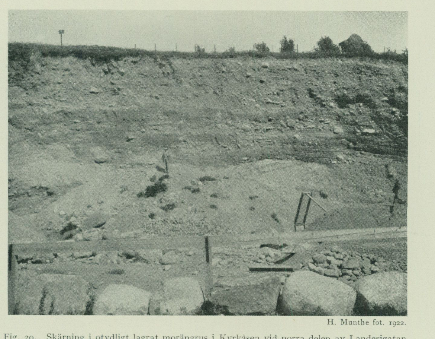
NW of Bäckebol in Backa parish. Since these deposits contain considerable quantities of gravel useful for practical purposes, they have been extensively exploited, and one therefore has the opportunity (in Kyrkåsen and at Lärje) to study their internal structure in good sections. In 1922, H. Munthe devoted a detailed investigation to the large sections running along Landerigatan in Kyrkåsen. The northern part of the section showed a 10—12 m high
H. Munthe, photograph, 1922.
Fig. 20. Section in indistinctly bedded morainic gravel in Kyrkåsen at the northern part of Landerigatan.
wall of morainic gravel with scattered boulders (fig. 20). The fine material consisted of sand and fine sand (mo). The mass as a whole displayed a certain bedding, but not the pronounced sorting or repeatedly discordant stratification characteristic of glaciofluvial deposits (see below). The indistinct bedding here displayed by the morainic gravel is probably attributable to the circumstance that the material, upon deposition at the ice margin, was, so to speak, tipped down the western slope of the Kyrkåsen hill into the sea, which at that time had a depth of about 70 m at this point.
Further S, at the corner of Uddevallagatan, the following sequence was measured (fig. 21):
A. About 2 m varved clay. B. 2 » morainic gravel, more or less distinctly bedded. C. 4—5 m bedded sand, at the base with layers of fat clay. D. » 2 m morainic gravel. E. 0.3 m + bedded sand.
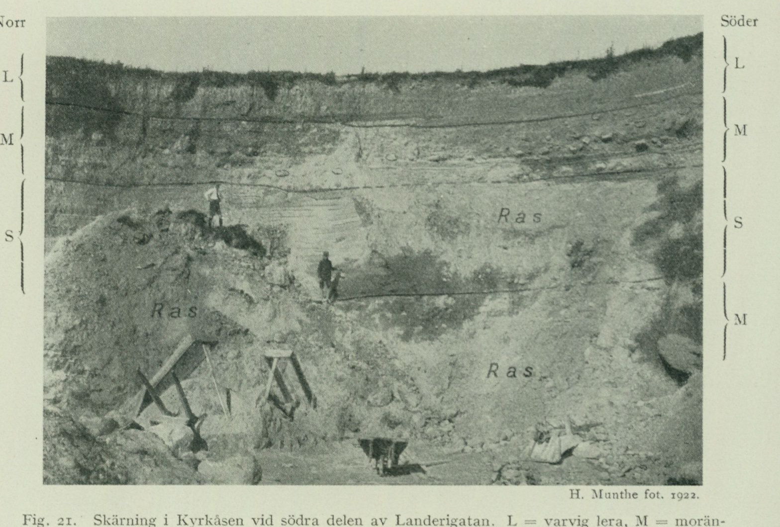
From this sequence it is clearly evident that the gravel masses present here were deposited during repeated minor oscillatory movements of the glacier ice, in the same manner as has recently been shown to have been the case with the large Finnish end-moraine formations.1 Thus, the layers consisting of bedded sand, E and C, were deposited in the sea in front of the ice margin, while the morainic banks, layers D and B, were laid down during advances of the ice margin. The varved clay, layer A, was
Profile orientation: North — South.
H. Munthe, photograph, 1922.
Fig. 21. Section in Kyrkåsen at the southern part of Landerigatan. L = varved clay, M = morainic gravel, S = bedded sand.

finally deposited after the glacier ice had definitively left the locality in question. An indication that the ice-margin oscillations in question need not be considered to have amounted to any great extent in the horizontal direction is provided by the fact that, according to photographs taken by J. Alin in 1926 (i.e., after gravel extraction had continued further E), the sections show morainic gravel almost exclusively even at the southern part of Landerigatan. That the oscillations were nevertheless not of a purely incidental nature is evident, however, from the fact that similar depositional conditions also occur in the glaciofluvial deposits belonging to the same zone of end-moraine formations (see below p. 71).

Another sequence showing similar conditions was exposed in 1922 within the area marked on the map as beach gravel N of Västra begravningsplatsen. The sequence here was as follows (fig. 22):

     1 Brenner, Thord and Tanner, V., Södra Salpausselkäs byggnad i järn vägsskärningen för Lahti
—Heinola-banan. Fennia 52, N:o 9, H:fors 1930.
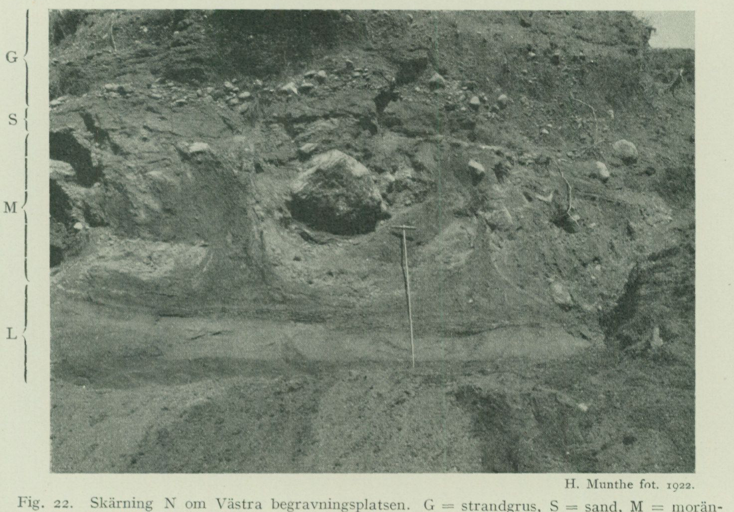
A. About 1 m wind-blown sand (in the image visible only at the top to the right). B. > 1 m beach gravel. C. 0.3 m sand. D. » 1.5 » till gravel, containing strongly contorted parts of stratified sand with thin clay bands. E. 0.5 » + stratified clay and sand.
H. Munthe, photograph, 1922. Fig. 22. Section N of Västra begravningsplatsen. G = beach gravel, S = sand, M = till gravel with pushed parts of stratified sand and clay, L = stratified clay and sand.
According to observations somewhat further W, layer E rests on a glacially polished bedrock outcrop with a little till gravel in depressions on the lee sides. The layer sequence shows that the ice sheet also here made a minor advance, which furthermore led to the development of a marked zone of marginal deposits (see below p. 74).
Erratic boulders. The boulders and stones present in the till gravel and its reworked products (glaciofluvial gravel, wave-washed gravel) consist for the very most part of such rocks as belong to the area’s own bedrock. But in addition, a larger or smaller quantity of boulders of rocks from sometimes quite distant areas are also found. These foreigners can be referred to three different categories with regard to the manner in which they have arrived at their present location. The first group comprises the so-called indicator rocks, which are embedded in till or glaciofluvial gravel and derive from such more or less remotely situated tracts as the inland ice had passed before it reached the map-sheet area. They can thus serve as a guide in assessing the ice’s movement directions, hence the name. Among indicator rocks found within the map sheet
Göteborg, mention may be made of Cambrian sandstone and Kinne diabase from Falbygden and the Västgötabergen, Jotnian sandstone from Dalarna or the Trysil field in Norway, porphyries from Dalarna, etc. The second group comprises the so-called drift-ice boulders, i.e. boulders that have arrived at their present location by means of floating icebergs. Thus, rocks foreign to the area, which are indeed found in wave-washed gravel and other marine sediments but never in till or glaciofluvial gravel, are classified as drift-ice boulders. Among the drift-ice boulders on the Göteborg map sheet, flint and other rocks belonging to the Cretaceous system, which likely derive from Skåne and Denmark or possibly from Cretaceous deposits outcropping on the floor of the Kattegatt, should be mentioned in the first place. The third group comprises such boulders that have been brought here from foreign places through human activities. These primarily include boulders that have been used as ballast, and unloaded from ships at harbors and loading places, or that have been left near the shore during ship strandings and picked up by the surf. Ballast boulders can easily, if their true character is not revealed, give rise to misleading geological conclusions.1 Among the foreign rocks occurring as loose boulders within the Göteborg map sheet, the following should be mentioned. Dala porphyries (most boulders belonging to the Bredvad type) have been found in till on Grötö and at Olskroken (Kyrkåsen) and as drift-ice boulders on Rammen (E of Rörö). Dala sandstone has been found in till on Hönö, in glaciofluvial gravel at Västra Begravningsplatsen in Göteborg, and at Tuve, additionally as drift-ice boulders on Hönö and on Amhultsholmen in Torslanda parish. Lower Cambrian sandstone has been found in till on Hönö, in glaciofluvial gravel at Västra Begravningsplatsen, at Tuve, at Rösered in Angered, and at Skårdal in Nödinge parish, as drift-ice boulders on Hönö, Kalvö, Björkö, and at Hästevik in Torslanda parish. Ordovician limestone, probably from the Trinucleus beds of Västergötland, has been found in glaciofluvial gravel at Västra Begravningsplatsen in Göteborg. Kinne diabase from Västergötland has been found in till on Hönö, as drift-ice boulders on Klätten (SW of Fotö) and at Hästevik. The post-Silurian intrusive rocks of the Oslo Field are not uncommon as drift-ice boulders in the archipelago. Essexite has been found on Hönö, a red quartz porphyry on Björkö, and various porphyritic dyke rocks, more or less resembling rhomb porphyry, on Hönö, Björkö, Rammen, and Amhultsholmen. A large boulder of rhomb porphyry has been observed within the till area E of Larsered in Säve parish. Chalk limestone and especially flint, both belonging to the Danian, are very common as drift-ice boulders. Flint has thus been recorded, inter alia.
1 See regarding this, e.g., Wallerius, I. D., Ett par bohusländska blocknotiser. G. F. F. Bd 51, 1929, pp. 100—104 and Wiman, C., Om förekomster av fossilförande block. G. F. F. Bd 52, 1930, pp. 134—135.
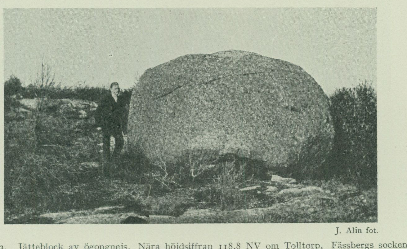
from the following localities: Tannskär in Styrsö parish, Hönö and Rammen in Öckerö parish, Hästevik and Amhultsholmen in Torslanda parish, Lilleby, Halvordsäng and Kvistljungby in Björlanda parish, Västra Begravningsplatsen in Göteborg, Grimbo in Tuve parish, and Almedal and Kärralund in Örgryte parish. Chalk limestone has been encountered on Hönö, Kalvö, Björkö and Rammen in Öckerö parish, as well as at Hästevik and on Amhultsholmen in Torslanda parish. The chalk limestone boulders are often rich in bryozoans (bryozoan chalk). Among other Cretaceous fossils found in boulders from the Göteborg map sheet may be mentioned Echinochorys sulcatus and Pecten inversus (Nilss.) from Hästevik, and Terebratula lens (Nilss.), an impression in a small flint axe from a settlement site NE of Tumlehed in Torslanda parish.
J. Alin, photograph.
Fig. 23. Giant boulder of augen gneiss. Near the elevation figure 118.8 NW of Tolltorp, Fässbergs parish.
The erratic boulders can sometimes reach highly considerable dimensions, and when their size amounts to or exceeds a dozen or so cubic metres, they may suitably be termed giant boulders. Such boulders as a rule lie more or less freely on the surface of the glacial formations, and in many cases were probably deposited there from the outset as the ice melted away, but in other cases they clearly appear to constitute remnants of a till cover, whose finer constituents have been transported away through the action of waves. This applies in the first place to such boulders as, below the highest marine limit, lie entirely free on bare rock. The giant boulders have at all times, through their seemingly inexplicable occurrence, set the popular imagination in motion, and many such boulders have received names, linked either to some legend or to some peculiarity in their appearance. In recent times it has happened increasingly often that giant boulders have been blasted apart for use as building stone or simply out of mischief. Admittedly, during the last few years a number of giant boulders in our country have been protected through the Act on the Protection of Natural Monuments, but the most important thing, however, is that the general public gains understanding of the idea of nature conservation, whereby all unnecessary damage to the nature surrounding us, without the compulsion of legal provisions, is branded as unworthy of civilized people. The giant boulders
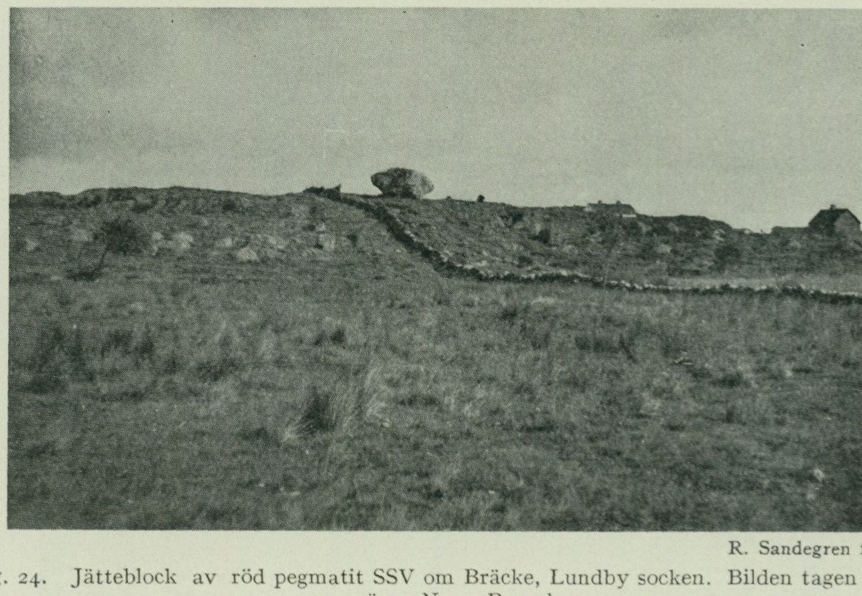
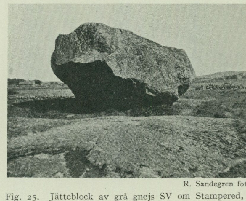
ought to be preserved both in their capacity as natural monuments from the Ice Age and as a picturesque element in the landscape. Within the Göteborg map sheet, the following more notable giant boulders have been recorded during the geological field work: Fässbergs par ish. A boulder of augen- gneiss near the elevation figure 118.8 (NW of Tolltorp). Dimensions 6 x 4 x 2.5 m (fig. 23). A boulder NNW of the preceding one and of approximately the same size. R. Sandegren, photograph, 1922.
Fig. 25. Giant boulder of grey gneiss SW of Stampered, Björlanda parish.
Göteborg city. A boulder of augen gneiss on the height S of Säldammen in Slottsskogen. Dimensions 4 × 2 × 1.2 m. A boulder of grey gneiss in the forest ESE of the office in Slottsskogen. Dimensions 4 x 4 x 1.3 m. Lundby parish. A boulder of red pegmatite on bare rock SSW of Bräcke. Dimensions
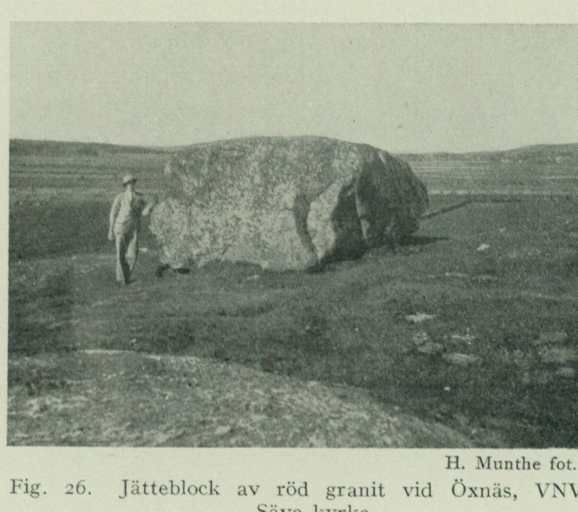
5 x 4 x 2.5 m (fig. 24). The boulder, together with several others of smaller size, which are scattered in a southeasterly direction up to the access road to Färjenäs, probably mark parts of the end moraines occurring S of Bräcke that have otherwise been washed away by wave action. About 340 m W of Häröd lie the remains of an even larger boulder that has been blasted apart.
Björlanda parish. A boulder of grey gneiss SW of Stampered (about 600 m S of Häröd in Lundby parish). Dimensions 5x3x3m (fig. 25).
Säve parish. A boulder of red granite on bare rock at Öxnäs. Dimensions 5x4x2m (fig. 26). According to legend, a giant attempted to hurl this boulder at Säve kyrka, but failed.
Angereds par- ish.
H. Munthe, photograph, 1921.
Fig. 26. Giant boulder of red granite at Öxnäs, WNW of Säve kyrka.
Several large boulders of augen gneiss WSW of Rösered on the western part of the great marginal esker. Still more such boulders formerly existed here, but have been used as building stone. A boulder of augen gneiss 600 m NE of Forsbäck. Dimensions 9x6x6m.
Glaciofluvial deposits.
During the melting of the inland ice, a substantial part of the meltwater flowed forward in tunnels beneath the ice. In doing so, the water, forced out under strong hydrostatic pressure, carried and processed the till gravel present there, whereby the angular stones contained in it acquired a more or less rounded form. Where the tunnels opened at the ice margin, this hydrostatic pressure, thanks to which the water had been able to transport boulders of up to even 1/2 metre in cross-section, ceased abruptly, and all the coarser material, the glaciofluvial gravel, was deposited immediately. Of the finer material, the sand was carried somewhat farther away and the finest clay slurry far out into the sea, where it, beyond the reach of the current, could settle to the bottom. The material in the glaciofluvial deposits was thus sorted according to grain size. Variations in the direction and volume of the water rushing out of the tunnel mouths produced the characteristic discordant bed-
    and the alternation between layers of coarser and finer gravel and sand.
   As the ice edge retreated annually, the tunnel mouths also moved back, and the glaciofluvial gravel was therefore often deposited in long, more or less continuous ridges (eskers) extending in the direction of ice movement (i.e. approximately perpendicular to the ice edge).
     When, during certain phases of the deglaciation, the ice edge remained stationary for a number of years or even made a renewed advance, the gravel accumulated outside the tunnel mouths forced the sediment-laden meltwater streams to deflect sideways along the ice edge, whereby the deposited material accumulated as transverse ridges, which, unlike the aforementioned (radial) eskers, are extended parallel to the ice edge like the end moraines and, together with these, build up the marginal formations, through the course of which one obtains knowledge of the position of the ice edge during different stages of its recession.
      During longer stationary periods in the ice retreat, which were often accompanied by small oscillatory advances of the ice margin, the water was forced to stream up over the transverse ridge formations, whereby the deposited material accumulated into more or less extensive delta-like formations, marginal deposits. If the building-up of the marginal deposits, before recession resumed, had proceeded so far that their surface approached the then existing sea level, they received an upper surface regulated by this, sometimes almost perfectly flat, and are then called marginal plateaus.
      Among the glaciofluvial deposits within the Göteborg map sheet there is only one typical radial esker, while transverse ridges and marginal plateaus are included in several of the zones of marginal formations identified here.
Radial esker. The radial esker appearing on the sheet (see fig. 14 and the map) begins immediately N of Bräcke in Lundby parish, where it appears as a not very thick, flatly ridge-shaped gravel deposit with SSW—NNE longitudinal extension. Its character as a radial esker is evident from its direction, which is parallel to the striations but perpendicular to the end moraine ridges appearing SW of Bräcke. The northern part of this esker segment is rich in large boulders at the surface, a circumstance probably due to the wave action here, where the location is higher and more exposed than near the hills immediately adjacent to Bräcke, having washed away the finer gravel and left the boulders behind. The map also shows that sand has a strikingly large distribution in this area and towards the SW down to the Älvsborgsfjorden around St. Rödjån, where perhaps also some now completely obliterated part of the same esker existed. The continuation of the esker towards NNE is found at and NNE of Grimbo in Tuve parish, where it has a beautiful and typical esker shape (fig. 27). E of Tuve stopping place there are large gravel pits in glaciofluvial gravel, from which the position of the esker here is evident, but the exploitation of the gravel has progressed so far that one can no longer obtain any impression of the original form of these esker segments. NNE of Lerbäck in Säve parish the esker swells out, evidently due to the stillstand in the recession of the ice margin that gave rise to the marginal moraines occurring here. Two large accumulations of glaciofluvial gravel are thus found immediately inside the marginal
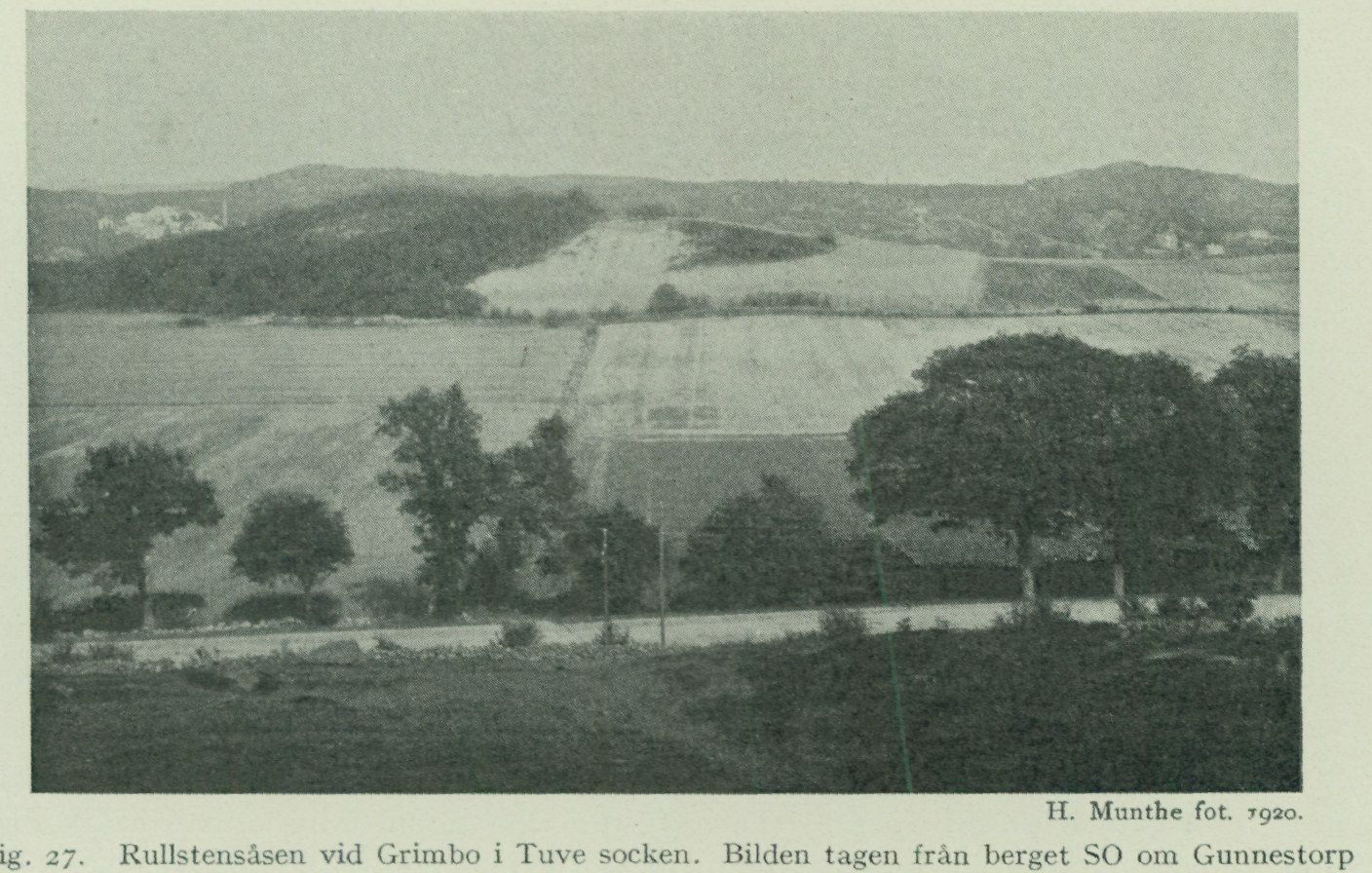
moraine zone, one N, the other S of the main road. Of these, the northern has a very pronounced esker shape. NNE of this the esker appears at Bönered, where the farms are situated on a high pronounced ridge, and also by the main road about 700 m NNE of the farms there is glaciofluvial gravel. After a larger gap the esker reappears W of Ellesbo in Rödbo parish. The glaciofluvial gravel here has no distinct esker shape, but has been, evidently through the action of wave action, leveled into a large, flatly vaulted cobble heath, whose
H. Munthe, photograph, 1920. Fig. 27. The esker at Grimbo in Tuve parish. The photograph taken from the hill SE of Gunnestorp towards SE. In the foreground the main road Göteborg—Tuve church, in the background the hills on the eastern side of Kvillebäcksdalen. In front of these the esker is visible, partly cultivated, but with a large gravel pit in its highest part. The wooded area N of the gravel pit consists partly of a protruding bedrock ledge, cf. the map.
highest parts reach up to nearly 80 m a.s.l. All around this appear large masses of shore gravel and sand, which soil types constitute reworking products of the glaciofluvial gravel. The large gravel pits at Rönning thus show coarse shore gravel overlying sand, but no actual glaciofluvial gravel. The continuation of the esker further towards NNE is probably to be sought in the marginal plateau at Skårdal (see below) and in the zones of cobble gravel that appear within Kilanda and Östads parishes and along lake Anten (see geol. Map sheet Borås, S. G. U. Ser. Ab. No. 7).
Most of the glaciofluvial deposits of the map sheet area have, however, the character of Transverse ridges and transverse ridges and marginal plateaus. marginal plateaus. At Färjenäs, glaciofluvial gravel in the form of a transverse ridge is piled up on top of the hill and on its western slope. The gravel is rich in large rounded boulders. At Carnegieska bruket on the southern river bank opposite Färjenäs there formerly existed a presumably very considerable transverse ridge formation. The large gravel pits here still show several metres of thick, coarse gravel, which at the bottom is strikingly
sandy. Judging from the masses of coarse boulders left behind after gravel extraction on the bottom of the pit, which partly consists of bare bedrock, the material was quite boulder-rich. The glacial-river gravel continues southward up onto the height, where it was levelled by wave action into a plane (see fig. 37) and further eastward approximately to Carl Johansgatan. The gravel immediately south of here, however, consists of a redeposition product of the glacial-river gravel resting on clay (shore gravel), but within the western part of the Western Cemetery there still remained in 1923 a small remnant of a cross-ridge consisting of typical glacial-river gravel poor in large boulders. In a gravel pit north of the road c. 500 m south of Carnegieska bruken the following stratigraphic conditions have been observed: A. c. 0.5 m varved clay. B. c. 5.5—6.5 m finely layered sand. In this, at about 1.5 m above the lower boundary of the layer, there was a layer of typical glacial-river gravel pinching out toward SSW and thickening progressively toward NNE, and somewhat deeper down in the sand yet another thinner such layer, and finally, near the bottom of the sand layer, there were a couple of thin, persistent layers of fat clay. C. glacially polished and striated bedrock.
The manner in which the glacial-river gravel occurs in the sand shows that it was deposited during an advance of the ice margin, after the lowermost part of the sand (with clay layers) had been deposited in the sea. The circumstance that the gravel layer in question increases in thickness toward NNE makes it likely that it is connected with the cross-ridge present in this direction and forms its outermost part projecting toward SSW. It is evidently the same ice-marginal oscillation that is registered in this stratigraphy and in the section in till north of the Western Cemetery described above on pp. 62—63. The distance between the two localities is c. 200 m. West of Sannegårdshamnen and up to Lundby nya kyrka there formerly rose a substantial cross-ridge formation, which, however, has now been exploited to the greatest extent. One thus now sees only a large gravel pit, in the bottom of which gneiss outcrops are exposed. To the same cross-ridge probably belongs the glacial-river gravel that to a large extent fills the valley of the Göta älv between Sannegårdshamnen and Stigbergskajen (see fig. 4). On the northeastern side of Lindholmsberget, east of Sannegårdshamnen, and at Lärjeholm in Angereds parish, glacial-river gravel of cross-ridge character is also found. The perhaps most remarkable of the marginal plateaus of the map-sheet area is the one that extends from the northern end of the lake Långvattnet in Fässbergs parish northward to the western side of St. Delsjön. The surface of this plateau, which may conveniently be termed the Delsjöplatån, reaches up to c. 95 m a.s.l., that is to say, nearly up to the highest marine limit, which here lies at 97 m a.s.l. (according to Munthe). From the 4—5 m deep sections that exist at the road west of St. Delsjön, it is evident that the uppermost, wave-washed parts of the marginal plateau consist of poorly sorted gravel with boulders and some sand. Eastward from the elevation figure 78.0, the wave-worked surface of the plateau is strewn with larger and smaller boulders, and such
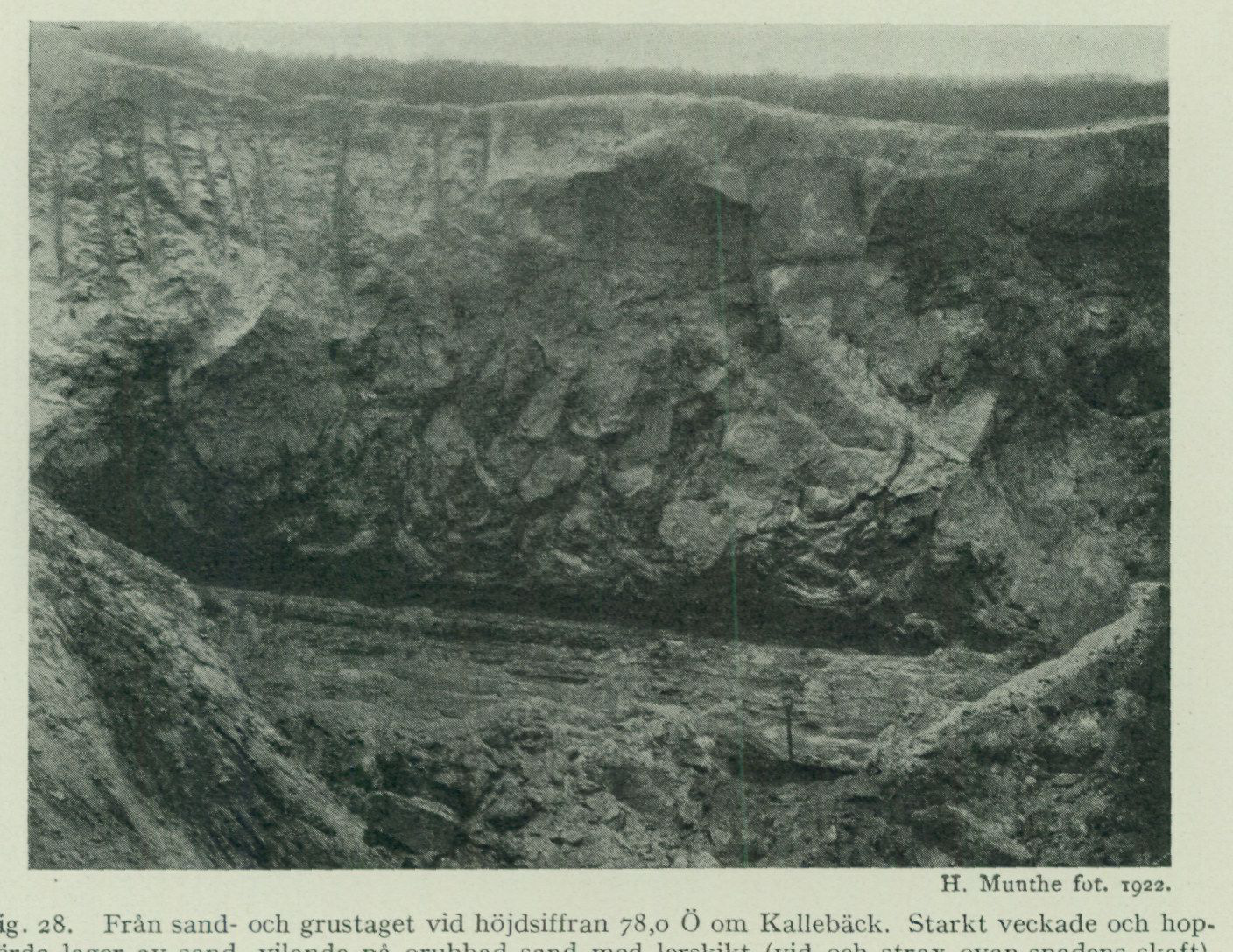
are also found immediately north of the waterworks at Långvattnet. To the east and west the plateau is partly framed by rocky heights. North of Långvattnet it shows a gentle slope toward the west, and in the northwest it slopes down toward the large Gunnlemossen, the surface of which lies c. 30 m below that of the plateau. That this deep depression, situated immediately adjacent to the marginal plateau, was not filled with glacial-river gravel is probably due to the fact that, at the time of the gravel’s deposition, it was occupied by dead ice, that is to say,
H. Munthe, photograph, 1922. Fig. 28. From the sand and gravel pit at the elevation figure 78.0 east of Kallebäck. Strongly folded and contorted layers of sand, resting on undisturbed sand with clay layers (at and just above the handle of the spade). At the blade of the spade the uppermost part of the 20 m thick glacial-river gravel is visible. Length of the spade 0.9 m.
ice masses cut off from the ice margin, which prevented deposition here and, upon their later melting, gave rise to depressions corresponding to the dead ice. In the plateau’s slope toward the west at the elevation figure 78.0, immediately south of the road, there is a large sand and gravel pit (fig. 28) that was studied in greater detail by H. Munthe in 1922. The stratigraphy was:
A. c. 8 m sand, especially downward showing strongly folded and contorted layers. B. c. 1 m sand, undisturbed, with clay layers. C. c. 20 m glacial-river gravel (according to boring). D. solid bedrock.
The strong deformation that the layered structure in layer B has undergone, and of which fig. 29 shows a detailed view, was in all probability caused by the ice having advanced over the sand layers (with clay
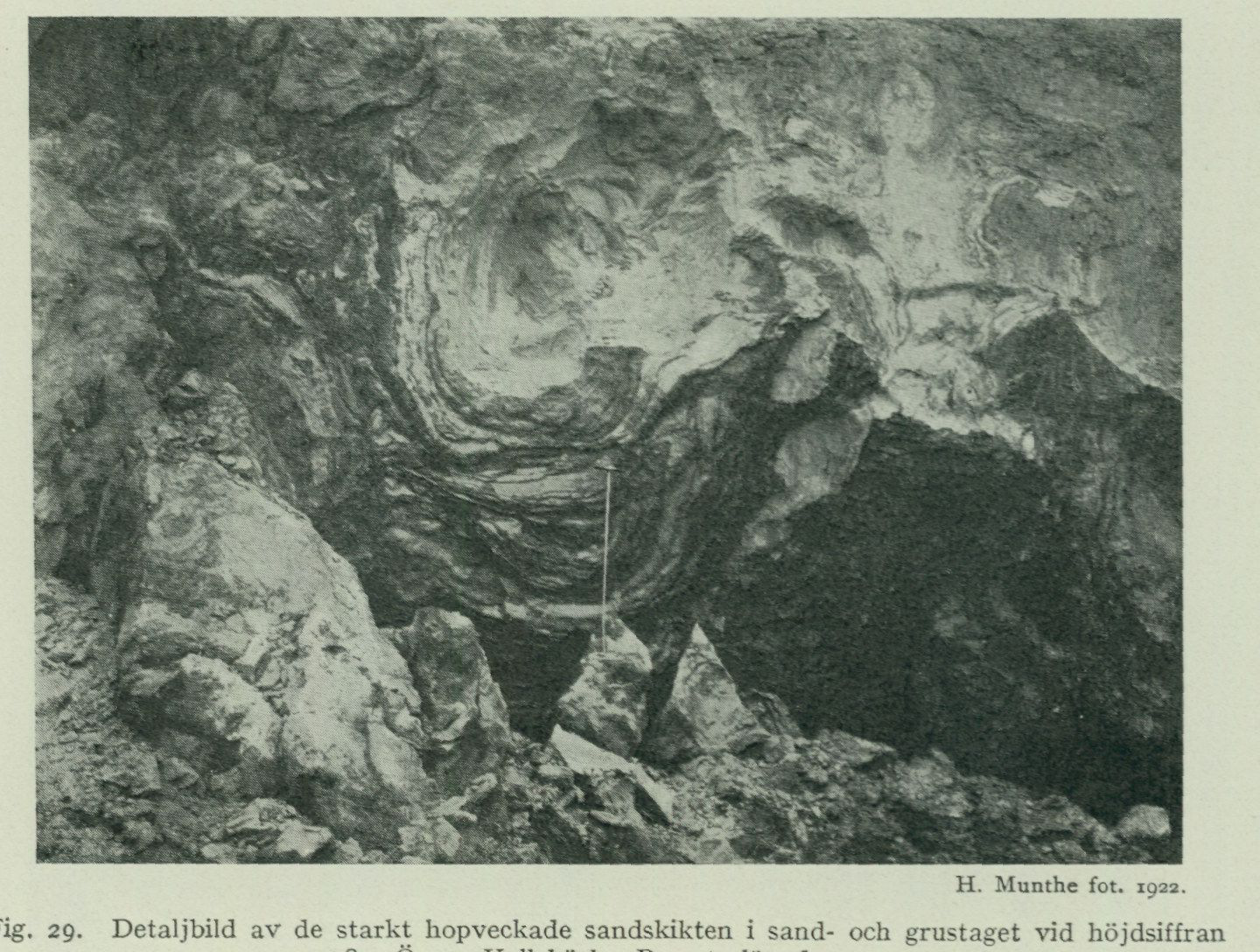
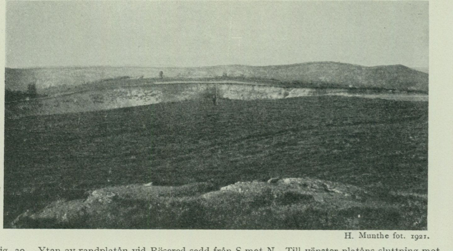
H. Munthe, photograph, 1922. Fig. 29. Detailed view of the strongly folded sand layers in the sand and gravel pit at the elevation figure 78.0 east of Kallebäck. Length of the auger in m.
H. Munthe, photograph, 1921. Fig. 30. The surface of the marginal plateau at Rösered seen from south toward north. On the left the plateau’s slope toward the west, in the middle the large gravel pit.
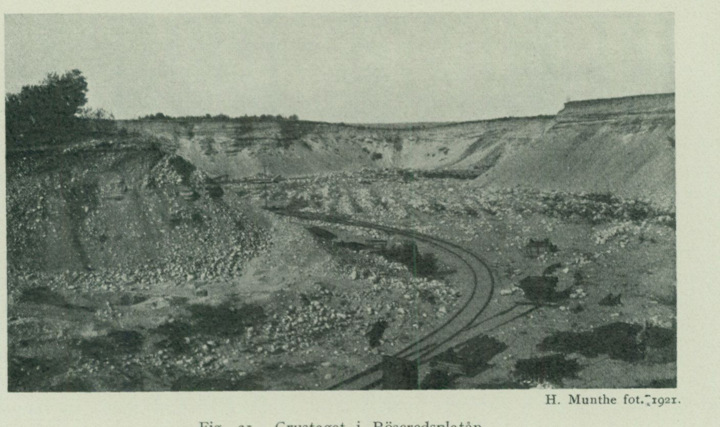
beds). Also in connection with the formation of the Delsjöplatån there thus appears to have taken place an oscillation of the ice margin.
From St. Delsjön, glaciofluvial deposits extend up to the area E of L. Torp. They are developed as more or less irregular marginal fields, but without plateau character, evidently due to their not having had time to build up so close to the contemporary sea level as was the case with the Delsjöplatån.
The largest and most beautifully developed of the map sheet’s marginal plateaux is that at Rösered in Angered parish, which may conveniently be termed the Röseredsplatån. Its uppermost flat surface (fig. 30) reaches up to 103.8 m a.s.l. The highest
H. Munthe, photograph, 1921.
Fig. 31. The gravel pit in the Röseredsplatån.
marine limit is situated here, according to a barometric levelling carried out by J. Alin, at approx. 108 m a.s.l. Towards the W the plateau displays a typical ice-contact slope. In a large gravel pit approx. 20 m deep (fig. 31) the internal structure of the deposit can be studied more closely. The material consists of typical, not particularly boulder-rich glaciofluvial gravel, here and there with discordant stratification and with beds of fine sand wedging out into the gravel. Through boreholes in the floor of the gravel pit it has been established that the gravel is underlain by several metres of extremely fine-grained sand, and since it has further been possible to establish, in at least one place within the southern part of the gravel pit, that coarse glaciofluvial gravel rests on sand beds showing disturbance phenomena similar to those described above from the gravel pit E of Kallebäck, it is clear that the Röseredsplatån too was deposited in connection with an oscillatory advance of the ice margin.
Glaciofluvial gravel of the marginal deposit type also occurs at Surte and at Skårdal in Nödinge parish. At the latter locality there is a true marginal plateau of the same type as the Röseredsplatån, though the dimensions are smaller. Here too disturbances occur in the sand beds, indicating an oscillation of the ice margin.
Ice-marginal lines.
Within the Göteborg map sheet one can distinguish at least seven more or less clearly developed ice-marginal lines. In general these probably only mark phases when the ice margin, during its retreat without any actual advance, stood still along a certain stretch. But at several localities belonging to lines 3, 6 and 7, sections have been encountered which, as described above, clearly show that the ice margin again advanced over areas that had already once been freed from ice.
A brief account of the various ice-marginal lines is given below, from the oldest to the youngest (see fig. 14).
-
The Hönö line. Across the whole of Hönö from SSE to NNW runs a continuous marked marginal moraine of low ridge form and a width varying between 100 and 200 m. Its continuation towards NNW can be followed in a series of scattered occurrences along the western shore of Öckerö, where the moraine has the same development as on Hönö.
-
The Grötö–Rörö line. The marginal moraines belonging to this line have the same form of development and approximately the same dimensions as the Hönö moraine. The most imposing is the moraine along the southwestern shore of Grötö (fig. 19). It is higher and displays sharper ridge form than the other marginal moraines in the archipelago. Its eastern, steep slope is wooded with oak, elm and linden and, through its height, offers shelter from the west wind to the settled and cultivated middle part of the island.
The ice-marginal line can be followed from Grötö towards NNW across Öckerö, Exholmen, and Hyppeln to Rörö, where it follows the greater part of the island’s western shore. Most likely it continues from here towards NW out into the sea, to be finally found again in the far NW in the considerable boulder accumulations on St. Rossen.
-
The Färjenäs line. This appears, at least along certain stretches, to be composed of two ice-marginal lines lying close together, and consists partly of cross- eskers and partly of marginal moraines. On the southern side of the Göta älv estuary one encounters the, prior to their exploitation for gravel extraction, considerable occurrences of glaciofluvial gravel at Västra begravningsplatsen and at the Carnegie works. On the northern side of the river one finds at Färjenäs two marked cross-eskers one behind the other, and these are continued towards NW by the double rows of end moraines SW of Bräcke. Further towards NNW, to judge from the direction of the striae, the continuation of this line is to be sought in the small but well-marked marginal moraines that occur SSE of Skäggered and SW of Lunnegården in Björlanda parish.
-
The Lundby line. This too is developed along certain stretches as two ice-marginal lines lying close together. In the far S the western of these is marked by the, prior to exploitation, so impressive accumulation of glaciofluvial gravel immediately W of Sannegårdshamnen, on the northern part of which the new Lundby church is situated. The eastern, in turn, is represented by the glaciofluvial gravel on the northeastern side of Lindholmsberget. As appears from fig. 4, the channel of Göta älv S of Sannegårdshamnen is to a large extent filled with glaciofluvial gravel, which evidently
constitute the continuation of the aforementioned cross-ridge formations toward the S. During the dredging of the harbour, the bottom here was found, at least in places, to consist of accumulations of large and small rounded stones, and prior to this dredging the current was so strong here that one could only with difficulty row up the river, which is why this stretch of the river was called »Matrospinan». The two cross-ridge formations at Sannegården and Lindholmen have to the northwest their continuation in two distinct end moraine ridges, the western one immediately NNW of Lundby gamla kyrka, the eastern one adjacent to the main road 400 m NNE of the same. The continuation of the ice-margin line further toward NNW is marked by the rows of beautiful, sinuous end moraine ridges that occur W of Kättilsröd, at Steneby and Alleby in Björlanda, and further up toward Kvillehed in Säve parish (see fig. 14 and the map). Particularly beautiful and well marked is the moraine ridge N adjacent to Steneby. Of special interest is to observe how both of the last-mentioned ice-margin lines 3 and 4 within Götaälvsdalen itself, where at the time of ice melting large quantities of subglacial meltwater had to force their way forward, are developed as cross-ridges (eskers), whereas on the flat plateau land of Hisingen they have the character of ordinary end moraine ridges. 5. The Tingstad line. At the southern sheet margin S of Lackarebäck, a robust end moraine, richly strewn with large boulders, extends in the direction N 30° W. This possibly belongs to the same ice-margin line as the marginal moraines appearing at Tingstad in Backa parish. NNW from Tingstad, the continuation of this ice-margin line appears to be sought in the sinuous row of scattered moraine accumulations, in several places of distinct marginal-moraine character, that occur E of Hökällan, S of Holm, W of Karlshed, and at both the southern and northern farms in Öxnäs. 6. The Delsjö line. To this belongs the Delsjöplatån and the accumulations of glaciofluvial gravel appearing N thereof, as well as the marginal moraines E of Olskroken (Kyrkåsen) and E adjacent to Lärje station. The glaciofluvial gravel and moraine tongues respectively, issuing from either side within Götaälvsdalen at Lärjeholm and NE of Bäckebol, indicate that the ice-margin line here crosses the river valley transversely. Its continuation toward NW can be followed in the partly quite considerable moraine masses, which with mostly well-developed marginal-moraine character extend from Bäckebol in nearly unbroken continuity toward Trollered in Säve parish. 7. The Rösered line. This is represented by the magnificent Rösered platå, but probably crosses Götaälvsdalen transversely immediately NW of it, in the same manner as line 6, and continues toward NW, for at and N of Kärra in Säve parish there lie two well-marked, boulder-rich end moraine ridges with an east–west principal orientation. The northern of these is gently arcuate, with the convex side facing south. Its northern side (proximal side) is not very steep and shows sandy material, while the southern (distal side) is rich in large boulders and considerably steeper. North of the Rösered platå, as mentioned above, glaciofluvial gravel appears at Surte and Skårdal, at least at the latter locality with marginal-plateau character, but the course of the ice-margin line or lines to which these formations belong cannot
be more precisely determined through the mapping carried out on the Göteborg sheet. Judging from the direction of the striae, the ice margin in this area had a nearly north–south orientation. Perhaps the continuation on the western side of the river of the ice-margin line to which the marginal plateau at Skårdal belongs is to be sought in the considerable marginal plateau at Dösebacka, N of Kungälv.
Late-glacial marine formations.
Level As a consequence of the considerable pressure exerted by the mighty inland ice changes. on the earth’s crust, the latter had been depressed, so that large parts of our country came to lie below sea level. When the ice began to melt away, this pressure diminished and the land began to rise again. Since the depression was greatest within the central parts of Scandinavia, where the ice cover had its greatest thickness, the postglacial land uplift has also reached greater amounts there than within the peripheral parts of the glaciated area. The highest marine limit (M. G.) therefore shows progressively higher values toward the north and inland, thus demonstrating the non-uniformity of the land uplift. Through the melting away of the land-ice masses, however, the water volume of the sea simultaneously increased, whereby the sea level was also caused to rise. Within areas where land uplift during a certain period proceeded more rapidly than the rise of the sea level, regression thus prevailed (i.e. a lowering of sea level relative to the land), while within areas where no land uplift took place, or where the uplift proceeded at a slower pace than the rise of the sea level, transgression occurred (i.e. a rise of sea level relative to the land). Within the Göteborg sheet and within the southern parts of our country generally, regression prevailed during late-glacial time, during postglacial time first transgression and then again regression1 (see fig. 36). As soon as the ice edge retreated from an area that lay below sea level, that area was thus covered by the sea, and in this sea deposition of clay, sand, or shore gravel commenced, all according to the level and situation the place in question occupied. Those parts of the area that happened to lie at and just below sea level were worked directly by the breakers, which washed down the till gravel left behind by the ice there and planed off the surface of the glaciofluvial deposits present, whose uppermost parts, like the aforementioned moraine tracts, were transformed into wash gravel and shore gravel. As the regression progressed, this washing of protruding rock masses and reworking of the loose material continued successively at ever lower levels, whereby eventually the surface layers of all till and glaciofluvial gravel were transformed into wash gravel and shore gravel, at least in places more exposed to the activity of the breakers.
1 Previously, the postglacial transgression was interpreted as being caused solely by an actual lowering of the land itself. The necessity of also taking into account oscillations of sea level when interpreting the level changes has been particularly emphasized by W. Ramsay in: »On the relations between Crustal Movements and variations of Sea-Level during the Late-Quaternary Times, Bull. Comm. Géol. Finl. N:o 66, 1924 and in: »Nivåförändringar och stenåldersbosättning i det baltiska området», Fennia 47, N:o 4, 1926.
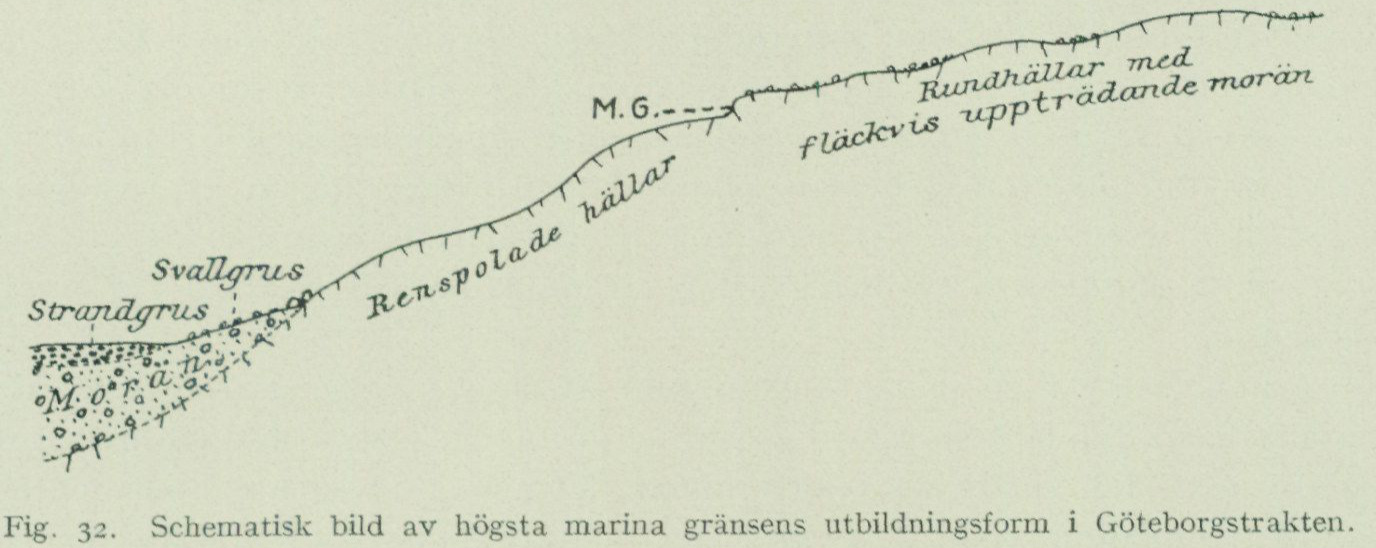
The highest marine limit (M. G.) is in these areas usually very weakly expressed in the terrain, because the till, as mentioned above, is extremely thin in the higher-lying areas and does not form any continuous cover. At favourable localities, however, such as where till remains on flat or gently sloping rock surfaces or in gentle slopes between the bare rock outcrops, one can, where no later solifluction has occurred, see how the till shows an abruptly truncated boundary downslope. Sometimes, with the aid of frost weathering, a small erosion notch in the solid rock has been able to form at the former shoreline itself. One or another metre higher up,
Fig. 32. Schematic illustration of the form of development of the highest marine limit in the Göteborg area.
depending on the more or less exposed position of the locality, one finds the highest swash limit of the breakers as a faint notch, above which unworked till material begins. Immediately below M. G. there is often a zone of completely washed-clean bedrock, generally amounting to one or a few tens of m in the vertical, and below this zone one finds swash gravel and shore gravel accumulated. See fig. 32.
Within the Göteborg map sheet, M. G. has been determined and levelled at the following localities: SE of Högsbo station (near the map elevation figure 105) 93 m a. s. l. Within the ridge between the map elevation figures 112.0 and 118.8 (SSE of Sahlgrenska sjukhuset) 95 m a. s. l. On the heights W, N and E of the northern part of Långvattnet as well as W adjacent to St. Delsjön 97 m a. s. l. NE of Utby in Partille parish near the eastern sheet boundary and NE of Lärjeholm (S of the Röseredsplatån) in Angered parish 108 m a. s. l. S of Skårdal (SE of Bohus station) in Nödinge parish 112 m a. s. l.
When the area had been freed from the ice, it was thus covered for the most part by the sea, from which only the very highest summits within the easternmost parts of the sheet rose as small rocky islets. Pl. 3 in »Göteborgstraktens geologi» gives an approximate picture of the distribution between land and water at this stage.¹
¹ It should perhaps be pointed out here that the value given in the aforementioned work for M. G. at Limsjöberget NW of Uddevalla, 126.5 m, is incorrect. From more recently acquired knowledge of the exact elevation of the triangulation point used during levelling, it appears that M. G. here lies at 154 m a. s. l.
Swash gravel and Within those parts of the map sheet that were submerged below sea level, till shore gravel. and glaciofluvial gravel, as mentioned above, were during the slowly continuing displacements of the shore successively more or less worked by the breakers. The surface layers of these deposits have therefore, within by far the greater part of the sheet area, been transformed into swash gravel and shore gravel.
The swash gravel is free from the finely particulate material characteristic of unworked till, which has been washed away, while the boulders have become concentrated at the surface. This washing-clean process is most fully developed in places that, by virtue of their position, have been particularly exposed to the action of the breakers, e.g. the terminal moraine ridges of the skerry zone, which often occupy the highest parts of the islands and have been transformed into boulder fields freed from all fine material, which cannot provide a foothold for any higher vegetation (fig. 19). In the same way, the surface layer of the glaciofluvial gravel in such openly situated places was freed from all finer, sandy material, and one finds there a covering of a swash gravel layer or of purely cobblestones on top of the normal glaciofluvial gravel, phenomena observed inter alia in two gravel pits in the marginal plateau at Skårdal in Nödinge parish.
The shore gravel is a redeposition product of till or glaciofluvial gravel. The material has thus been washed out from its original position and redeposited farther down. In its character it most resembles glaciofluvial gravel, but only exceptionally shows discordant stratification; rather, the beds dip more or less conformably with the slope of the terrain where it occurs. One therefore usually finds the shore gravel as a thicker or thinner mantle covering the till and glaciofluvial gravel in slopes situated below M. G., or else accumulated in the form of accumulation terraces at the foot of washed-bare rock heights. The thickness of the shore gravel generally varies between a few decimetres and one or another metre, but can sometimes amount to several metres. This is the case, for example, within certain parts of the shore gravel area between Västra begravningsplatsen and Carnegieska bruken. The shore gravel here has been formed at the expense of the easily eroded glaciofluvial gravel in the transverse ridge formations present here and rests on late-glacial clay, which about 500 m SSE of Carnegieska bruken has been shown by boring to have a thickness exceeding 6 m.
Shell gravel The shore gravel often contains shells of molluscs and other marine organ- banks. isms, and in places such calcareous shells constitute the main mass of the gravel, in which case it is termed shell gravel. Shell gravel accumulations of greater thickness are called shell gravel banks.
The shell gravel banks, both the late-glacial and the postglacial ones,¹ are always found, just like the shore gravel, immediately below more or less steeply rising —
¹ The investigations carried out in connection with the mapping of the marine shell-bearing deposits of the area, and which are intended to be presented in detail in the S. G. U. publication series C, have been aimed at elucidating partly the debated mode of formation and significance of the shell gravel banks for the shore-displacement problem, and partly the immigration of the marine fauna. The first question is discussed in this chapter, and for the latter a brief account is given in a separate chapter further on. Here, however, information must first be given regarding the division into late-glacial and postglacial, based on the faunistic investigations, which is applied in this description with regard to the shell-bearing marine deposits. Thus, those deposits are designated as late-glacial which contain only
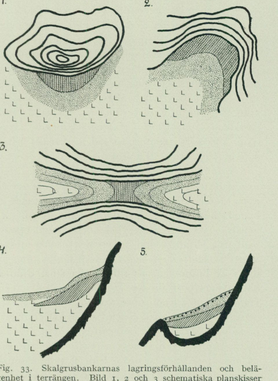
rising heights, never out in the middle of the plains. The location of the deposit is revealed in typical cases by a softly vaulted, terrace-like elevation of the ground adjacent to the rock slope. Closest to the rock, there is an indication of a lesser slope (terrace flat), followed by a section with a steeper slope (slip-off scarp). Here, the bank reaches its greatest thickness. Further out from the rock, the slope of the ground decreases, and the shell gravel bank tapers out, approximately where the slope imperceptibly transitions into the flat plain. See fig. 33, image 1, 2, and 4, which aim to illustrate the structure of such accumulation-terrace banks. In smaller, sloping valley troughs between rocky heights, the entire valley bottom is often occupied by an evenly sloping shell gravel layer without any more prominent accumulation-terrace form, for which reason shell gravel banks of this type may be termed valley-fill banks.
Fig. 33. Storage conditions and location of the shell gravel banks in the terrain. Images 1, 2, and 3 are schematic plan sketches of different types of shell gravel banks. 1 and 2 “accumulation terrace banks”, 3 “valley-pass bank”. Image 4 shows a profile of an accumulation-terrace bank, 5 profile of a “pocket bank”. Black or thick curves = rock, hatching = shell gravel (in the plan sketches covered by sand), finer and coarser dots = sand and gravel, L = clay.
Where shell gravel banks occur higher up on the slopes than at the foot of the rocks, they are located in small rock basins, “pockets”, in the rock slope, where thus a threshold has prevented the material from being transported further downwards by the waves (fig. 33, image 3), a type that may be designated pocket banks. Often, shell gravel banks are encountered at the highest pass threshold (watershed) in narrow, pronounced valleys (fig. 33, image 3). This type, which
such faunal elements as immigrated during the time the shoreline shifted from M. G. down to the level to which it was again shifted upwards during the postglacial transgression (P. G.). As postglacial are designated the deposits that were deposited after the shoreline, during the first regression, passed the P. G. level. Postglacial deposits are thus found only below the P. G. level. Late Glacial ones both above and below it. All species determinations of the fossil mollusks have been carried out by N. Odhner.
here may be designated valley-pass banks, probably owes its formation not only to the general downward transport of material from the valley sides but also to the special current and wave movements that manifest themselves in the water in a strait before and during the emergence of the pass threshold as a consequence of a regression. The general stratigraphy in the shell gravel banks is from bottom to top: 1. clay, 2. shell gravel, 3. shell-free sand or beach gravel1 and sometimes 4. on top a thin layer of shingle (fig. 33, image 4 and 5). At the distal tapering of the bank, clay usually occurs also on top of the shell gravel (fig. 33, image 4). The shell gravel always shows a more or less distinct stratification dipping away from an adjacent height (beach gravel stratification), and the shells are sorted according to size and weight, partly among the different individual layers and partly in general counted from the proximal to the distal part of the bank, so that the heaviest and largest components are found in the main part of the bank located closest to the height, while the shell material at the distal tapering of the banks exclusively consists of small forms and finely crushed shells. Thus, both from the location of the shell gravel banks in the terrain and from their internal structure, it emerges unequivocally that, geologically speaking, they are beach gravel deposits, which differ from corresponding formations built solely of mineral grains only in that the largest amount of the “stones and gravel grains” consists of whole and fragmentary mollusk shells. The shell gravel banks have thus originated through the mechanical enrichment of shells that occurred when shell-bearing clays, through land uplift, were brought up to levels reached by the erosion of the waves, active at quite great depths. The clay has been washed away to be redeposited in calm water at greater distances from the shore exposed to erosion, while the shells together with coarser sand and gravel have successively moved downwards during the regression, until they came to rest in such places in the terrain where further downward transport was no longer possible.12 During this downward transport, shells have accumulated from animals that lived at different times and at different depths, and shells that had been embedded in destroyed older deposits have been mixed with the fauna living during the time of the bank’s deposition. In a shell gravel bank, therefore, a part of the material always consists of redeposited shells, which may have undergone a perhaps repeatedly, quite significant transport, as evidenced by their often remarkably worn and fragmentary condition, while others (e.g. bivalves with both shell valves sitting together) have lived at the site or have only been transpor-
1 The shell-free uppermost sand or gravel layer has probably, in many cases, originated in such a way that the calcareous shells included in the originally deposited material were dissolved by percolating surface water, in which cases the layer in question is the result of the lime leaching associated with the usual soil formation processes. Cf. B. E. Halden, Sand pipes (»Geological organs») in shell gravel. G. F. F. Bd 47, 1925.
2 It may be emphasized here that the shell-bearing animals certainly did not live in the same abundance everywhere on the former seabed, but that the varying topography created both more and less favorable conditions for their well-being, whereby the animals primarily appeared more abundantly in one place than in another. For example, the importance of the current conditions in a strait for the supply of fresh, nutrient-rich water has been emphasized (N. Odhner, Some facts illustrating the shell bank problem, G. F. F. Bd 49, 1927). This circumstance must have been of importance, for example, for the formation of the above-mentioned valley-pass banks.
transported a very short distance. The occurrence of more or less arctic species, e.g. thick-shelled Saxicava arctica in postglacial shell banks, which otherwise contain a rich warmth-demanding fauna, must therefore be due to the shells of the arctic species having been eroded out of previously deposited late-glacial clays or shell banks and redeposited in postglacial time.
From this it follows, among other things, that faunal investigations of the shell content of shell banks through analyses of a number of samples in a vertical series through the bank can hardly, as a couple of researchers have done,1 be used as a basis for determining the successive immigration of species or of any changes in water depth at the site of deposition, at least not unless one can determine with absolute certainty for each individual whether it has been redeposited, has undergone downward transport, or has lived in situ. In a shell gravel bank it may even be impossible to determine which are older, the shells in the lower or upper layers of the bank. If, for example, a shell-bearing clay is attacked by erosion, the shells lying in the upper parts of the clay, and thus being youngest, are first washed down, thereafter, once erosion has cut deeper, the older shells from the bottom layers. In the shell gravel bank these will then lie uppermost; the stratigraphic sequence has become inverted and is entirely misleading if one seeks to draw conclusions from it regarding either the immigration sequence of species or shoreline displacement.
It is therefore exceedingly difficult to draw conclusions regarding alternating transgressive and regressive phases during the formation period of a shell gravel bank from frequency changes between deep-water species and shallow-water species in the mollusc fauna in a vertical sample series from a shell gravel bank. Furthermore, the elevation of a shell gravel bank above sea level indicates only a minimum measure of the regression of the sea level that has taken place since the time when the species contained in it lived. A combined study of the shell gravel banks and the shell-bearing clays, in which the shells may generally be considered to have remained in the position where the animals died, should, however, be able to provide more reliable information about the immigration and disappearance of species in relation to the shoreline changes.
After this general indication of the occurrence and probable mode of formation of shell gravel banks, a detailed description will first be given here to illustrate the aforementioned conditions — of the largest shell gravel bank in the map-sheet area — and then a list of the late-glacial shell gravel banks within the map-sheet area that have been more closely examined during the geological field work.
Shell bank at Skändla
The largest and thickest shell gravel bank within the Göteborg map sheet is a late-glacial bank situated at Skändla in Tuve parish, on the eastern slope of the 80.7 m high Skändlaberget. The bank forms a typical accumulation terrace, the highest part of which reaches 38.3 m a.s.l. A large gravel pit shows that the entire mass of the bank is distinctly stratified, with the beds dipping towards E, away from the mountain. The stratigraphic sequence, measured by N. Odhner, is as follows:
1 De Geer, G., Quaternary sea-bottoms in western Sweden. G. F. F. Bd 32, 1910. Antevs, E., Post-glacial marine shell-beds in Bohuslän. G. F. F. Bd 39, 1917. Antevs, E., Shell Beds on the Skagerack. G. F. F. Bd 50, 1928.
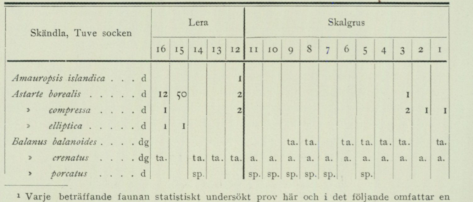
A. 0.2 m mould soil. B. 5.0 m stratified shell gravel in which the stratification appears through alternation between coarse shell gravel, finely crushed shell gravel and clayey shell gravel in the following manner: coarse shell gravel, sample No. 1, 0.40 m below ground surface. » » » » 2, 0.50 » clayey, finely crushed » » 3, 0.75 fine » » 4, 0.90 » coarse » » 5’ 0.95 fine 6, 2.00 thin clay layer, » » 7, 2.20 » fine shell gravel, » 8, 2.40 » coarse » , » 9, 2.90 » fine » , » 10, 4.00 » » » , » » 11, 5.00 » ■ C. 2.5 m clay, at the top shell-bearing, samples 12, 13, 14, 15 and 16 from suc cessively deeper levels, the lowermost 67 cm are shell-free and show distinct varvation. D. bedrock surface sloping towards E.
In the eastern part of the gravel pit the varved clay is absent, and thus the shell-bearing clay rests directly on the bedrock there. This is probably due to some portion of the varved clay having slid down from the smooth, polished sloping rock surface before the shell-bearing clay was deposited. The composition of the fauna included in the various samples is shown in the table below. The letters d, g, dg after the species name denote deep-water species, shallow-water species, and species living in both deep and shallow water, respectively (acc. to Antevs 1928). The frequency designations are: a = abundant, ta = fairly abundant, sp = sparse, the figures = number of specimens for gastropods and number of shell valves for bivalves.
                                  Clay                          Shell gravel
  Skändla, Tuve parish
                                                                                                                                                                                                                                                                                                                                                                                                                                                                                          !  7   6       |  5   4   3   2     1                                 l6  '5  14  .3  12 »  10  9   8
Amauropsis islandica . . d 1 Astarte borealis… d 12 2 1 > compressa … . d 1 2 2 I I » elliptica… d 1 I Balanus balanoides … . dg ta. ta. ta. ta. ta. ta. ta. > crenatus … . dg ta. ta. ta. ta. a. a. a. a. | a. a. a. a. a. ; a. a. > porcatus … . d sp sp. sp. sp. sp. sp. sp.
1 Each statistically investigated sample regarding the fauna here and in the following comprises a volume of approx. 1 liter.
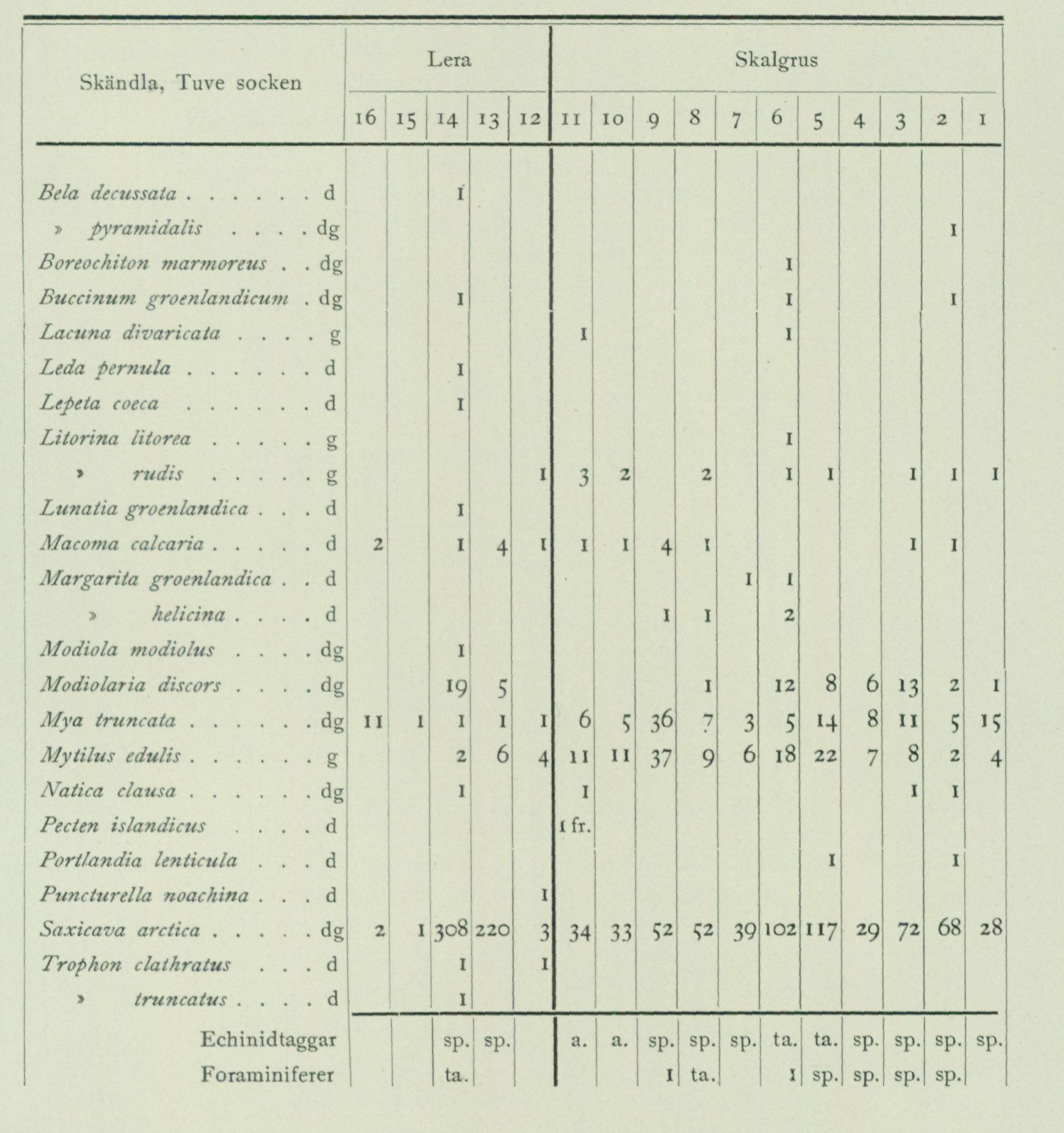
                                 Clay                          Shell gravel
  Skandia, Tuve parish
                             16  15       13  12  11  10   9   8    7   6    5   4   3   2     I
Bela decussata… d » pyramidalis … . dg I Boreochiton marmoreus . dgl I Buccinum groenlandicum dg I I I
1 Lacuna divaricata . . . ' I
Leda pernula… d I Lepeta coeca… d I Litorina litorea … g 1 » rudis … g I 3 2 2 I 1 I I 1 Lunatia groenlandica . . d I Macoma calcaria … d 2 I 4 I I 1 4 I I I Margarita groenlandica . d 1 1 » helicina … d I I 2 Modiola modiolus … dg; I Modiolaria discors … dg 19 5 I 12 8 6 »3 2 1 Mya truncata… dg; II 1 I 1 1 6 3 36 7 3 5 ■4 8 II 5 15 Mytilus edulis… g 2 6 4 11 II 37 9 6 18 22 7 8 2 4 Natica clausa… dg’ I I I I Pecten islandicus … d I fr. Portlandia lenticula . . d I I
Puncturella noachina . . d I 000 220 3 34 33 32 32 39 102 117 29 72 68 28 Saxicava arctica … dg 2 I Trophon clathratus . . d I I » truncatus … d 1 I
             Echinoid spines        |           sp.  sp.        a.   a.   sp.  sp.  sp.  ta.  ta.  sp.  sp.  sp.  sp.
             Foraminifera       |            ta.                                         I  ta.             I  sp.  sp.  sp.  sp.
Late glacial shell gravel banks.
Torslanda parish.
Nolered. In a depression in the bedrock about 800 m WSW of the farmstead, 45 m a.s.l. 56 % of M. G. 12 species. This bank has also been investigated by Antevs (G. F. F. 1928, p. 580—581). He states, however, its height above sea level incorrectly as approximately 30 m and considers it to lie at approximately 40 % of M. G., for which reason his conclusions regarding the level conditions at its formation are entirely incorrect. SE of Tumlehed. In a depression in the bedrock about 800 m SE of the farmsteads. 45 m a.s.l. 56 % of M. G. 8 species. Gossbydal, Amhult. Valley fill at the highest threshold pass in a north-south-trending valley. The bank shows a clay layer between two shell gravel beds (see p. 89 and 91) 43.2 m a.s.l. 54 % of M. G. 13 species (species list p. 89). S of Tumlehed. Valley fill at the highest threshold pass in the valley extending from Tumlehed towards SE to Amhult, 39.6 m a.s.l. 50 % of M. G. 15 species.
The thickness of the shell gravel is 1.5 m. This bank has also been investigated by Antevs (G. F. F. 1928 p. 582—583). He states, however, its height above sea level incorrectly as about 20 m and considers it to lie at about 25 % of the M. G. [Highest Coastline], wherefore his conclusions regarding the level conditions at its formation are quite incorrect. NW of Amhult. Valley fill about 800 m from the farms 36.6 m a. s. l. 46 % of M. G. 8 species. Underlain by shell-bearing clay (see p. 91). W of Amhult. Valley fill in eastward-sloping terrain about 1500 m WNW of the farms. 30 m a. s. l. 38 % of M. G. 11 species. W of Flyghamnen. Valley fill about 1 km W of the hangar building. 30 m a. s. l. 38 % of M. G. Immediately SE of the bank the rock rises to 50.9 m a. s. l. 16 species.
V. Frölunda parish.
Bua. In a depression between rocks about 800 m NW of the farm. 65 m a. s. l. 72 % of M. G. 4 species. Käringberget. In a depression in the rock SE of the triangulation point 25 m a. s. l. 30 % of M. G. 15 species¹.
Fässbergs parish.
W of Krokslätt. In a depression between rocks under 0.5 m peat. 60 m a. s. l. 63 % of M. G. 3 species. NE of Högsbo. In a valley pass between rocks about 500 m NE of the stopping place. 55 m a. s. l. 59 % of M. G. 7 species¹.
Lundby parish.
NNW of Bräcke. Valley fill about 1 km from the farm 55 m a. s. l. 61 % of M. G. 6 species¹. NW of Tolered. Valley fill about 500 m from the farm. 50 m a. s. l. 54 % of M. G. 6 species¹. Ardal. Accumulation terrace on northeast slope about 1 km N of the steamboat pier. 33 m a. s. l. 38 % of M. G. 19 species. The shell gravel has a thickness of about 1.5 m and is underlain by late-glacial shell-bearing clay (see p. 91). NNW of Syrhåla. Valley fill in southward-sloping terrain about 600 m from the farms. 25 m a. s. l. 29 % of M. G. 12 species.
City of Göteborg (excluding Lundby and Örgryte.)
Slottsskogen. In Påfågelshagen in a hollow between rocky knolls. 61 m a. s. l. 63 % of M. G. 5 species¹. The thickness of the shell gravel is at least 0.5 m. Larje. 500 m E of the stopping place, on the eastern slope of the height consisting of rock and till. 55 m a. s. l. 53 % of M. G. 7 species¹. N of W. Cemetery. Interbedded with shell-bearing clay (see p. 90 and 91) 38 m a. s. l. 42 % of M. G. 18 species (species list p. 90).
Örgryte parish.
Fräntorp. Valley fill in slope about 300 m S of the farm 55 m a. s. l. 54 % of M. G. 2 species. Fräntorp. Beach-spur-like formation immediately S of the preceding. 45 m a. s. l. 44 % of M. G. 6 species.
Björlanda parish.
E of Sörröd. Valley fill at the highest pass threshold in a north—south-trending valley about 800 m from the farms. 55 m a. s. l. 64 % of M. G. 11 species¹. The thickness of the shell gravel is about 1/2 m, underlain by clay.
1 Species list in »Geology of the Göteborg area».
S of “T e l e g r a f b e r g e t”. Accumulation terrace below the southern slope of the hill. 45 m a. s. l. 55 % of M. G. 11 species. The thickness of the shell gravel is at least 2 m. SE of “T e l e g r a f b e r g e t”. Accumulation terrace below the hill at the innermost end of a southeastward-trending valley. 39 m a. s. l. 48 % of M. G. 13 species. E of “T e l e g r a f b e r g e t”. In a valley about 1600 m E of the signal. 30 m a. s. l. 35 % of M. G. 14 species. NW of Lilleby. In a depression in the rock about 900 m from the farms. 30 m a. s. l. 35 % of M. G. 16 species. W of “T e l e g r a f b e r g e t”. Accumulation terrace below the hill at the innermost end of a westward-trending valley. 27.5 m a. s. l. 33 % of M. G. 15 species. S of Lilleby. Valley fill at the highest pass threshold in an ENE—WSW-trending valley, 26 m a. s. l. 30 % of M. G. 13 species. The thickness of the shell gravel is about 1 m. Kvistljungby. In a depression in the rock about 1 km W of the farms. 26 m a. s. l. 29 % of M. G. 31 species. The thickness of the shell gravel is about 1 m.
Tuve parish.
SW of Grimbo. In a valley slope about 300 m from the farms 70 m a. s. l. 72 % of M. G. 6 species¹. W of Grimbo. In a depression in the rock about 1600 m from the farms 55 m a. s. l. 57 % of M. G. 4 species. NW of Grimbo. Accumulation terrace in valley slope about 500 m from the farms. 50 m a. s. l. 51 % of M. G. 16 species. Skandia. Accumulation terrace below the eastern slope of the hill N of the farms. 38.3 m a. s. l. 37 % of M. G. 21 species. The shell gravel has a maximum thickness of 5 m and is underlain by 2 m late-glacial shell-bearing clay (see pp. 81—83, species list). Backa parish. Bäckebol. Accumulation terrace below a rocky height. 70.1 m a. s. l. 67 % of M. G. 6 species. The shell gravel has a thickness of about 1 m and is underlain by late-glacial shell-bearing clay (see p. 92). Tingstad. Valley fill at the highest pass threshold in a WNW-to-ESE-trending valley depression in the rock about 1,100 m NW of the railway station. 65 m a. s. l. 66 % of M. G. 7 species¹.
Angered parish.
SE of Assared. Accumulation terrace in a valley about 500 m from the farm. 62 m a. s. l. 60 % of M. G. 7 species.
Säve parish.
Gerrebacka. Accumulation terrace on the western slope of the hill located immediately E of the farm. 74.7 m a. s. l. 70 % of M. G. 8 species. Bönered. Valley fill at the highest pass threshold in a valley depression about 600 m SSE of the farms. 65 m a. s. l. 63 % of M. G. 5 species. Österslätt. In a depression in the rock NE of the farms. 62 m a. s. l. 59 % of M. G. 4 species. Svensby. Valley fill at the highest pass threshold in a valley depression about 700 m E of the farms. 43 m a. s. l. 42 % of M. G. 9 species.
Rödbo parish.
Pileröd. In a depression in the rock SE of the farm. 60 m a. s. l. 56 % of M. G. 6 species.
> Species list in »Geology of the Göteborg area».
                                    Harestads parish.
    W of  V. Röd.  Valley fill about 2.5 km from the farms 65 m a. s. l.  69 % of
     M. G.  9 species.
    W of  V. Röd.  Valley fill about 800 m from the farms, 50 m a. s. l.  51 % of
     M. G.  8 species.

                                      Torsby parish.
    Ranneberg.  In a depression in the bedrock about 500 m SSW of the farm.  56.4 m a. s. l.
      57 % of M. G.  7 species.
         L. Holm.  Valley fill about 500 m N of the farms 30 m a. s. l.  31 % of M. G.
      9 species.  The shell gravel, which probably had a thickness of at least 2 m, is now for the most
      part removed.
    Hålisung.  Accumulation terrace below a bedrock slope about 1 km ESE
   of the farms.  30 m a. s. l.  31 % of M. G.  13 species.
Late-glacial Late-glacial sand or glaciomarine sand has, in the same way as beach gravel, been sand. formed through the eroding action of breakers on the older deposits and deposited on slopes and in depressions outside the then-existing shores, generally farther from the shore than the beach gravel or in places less exposed to breakers. One therefore cannot in general draw any definite boundary on the map between beach gravel and sand, as the material shows a gradual transition from the coarse, proximal beach gravel to the fine, distal sand deposited in quieter water. The thickness of the glaciomarine sand varies between a few decimetres and a couple of metres. It is often underlain by glaciomarine clay. In many places the sand includes, like the beach gravel, shells of marine molluscs. Large quantities of sand were also carried by the glacial rivers out into the sea and thus constitute the distal portions of the glaciofluvial gravel. Such sand is therefore often found as the nearest substrate beneath the glaciomarine clay. In the foregoing, several examples have been mentioned where such sand deposits have been disturbed and thrust together or overlain by till or glaciofluvial gravel during oscillatory advances of the ice margin.
Glaciomarine clay. The glaciomarine clay, in unweathered condition, is usually of grey-blue to faintly chocolate-brown colour and possesses, mainly owing to embedded calcareous shells, often a more or less prominent lime content. Through weathering the lime is dissolved, and the clay acquires various dark brown or yellowish colour shades. The varvity, caused by the annual periodicity in the glacial rivers’ supply of silt, which appears so clearly in the late-glacial clays within many parts of our country, is less sharply developed within the coastal tracts of western Sweden and occurs there only within the lowermost parts of the glaciomarine clay. This circumstance has its cause in the high salinity of the sea. In salt water, bottom deposition of clay silt takes place in a different manner than in fresh water, and no varvity is obtained. It was therefore only nearest the ice margin, where the salinity was strongly diluted on account of the outflowing meltwater masses, that annual varves could become developed, whereas the clay deposited farther from the ice margin became homogeneous. A fully distinct annual varvity in the bottom
layers has, however, been observed in several places, e.g. at the NE end of Ram berget, at Kyrkåsen (cf. above pp. 61—62), at Skandia in Tuve parish and at Steken in Angered parish (cf. below pp. 126—128). The investigations of the character of the glaciomarine clay, which the Göteborg Harbour Board has carried out on samples from a number of localities within the harbour area, have, among other things, yielded the result that the clay, sometimes at these low levels, possesses a very high water content. At times, nearly 2/3 of the clay’s volume consists here of water, for which reason in such cases it would be more correct to speak of clayey water than of water-bearing clay. It is therefore evident that the difficulties that have been and are to be overcome in quay construction and other building works on such a substrate, often of great thickness, are exceedingly great (cf. above pp. 9—11)* The glaciomarine clay sometimes contains a considerable content of sodium chloride. According to investigations carried out by A. Atterberg1, the sodium chloride content in a number of samples varies between 2.25 and 1.85 per cent. As appears from the map, clay has a great distribution on the Göteborg sheet, where all larger plains and valley tracts are occupied by this soil type. However, the glaciomarine clay crops out only exceptionally, since in most cases it is covered by postglacial marine clay of varying thickness. Only above the postglacial limit or adjacent to protruding bedrock heights does the glaciomarine clay thus reach the ground surface. Owing to the difficulty of consistently distinguishing the late-glacial and postglacial clays from one another during mapping, in the heavily weathered condition in which they occur within the generally cultivated clay lands, all marine clay on the map has received the same symbol. The glaciomarine clay, at the time of its deposition, presumably originally covered very large areas of what is now bare bedrock, from which the clay material was subsequently washed away by breakers during the progressively occurring regression and, anew, in part first in postglacial time, came to be deposited within the low-lying areas. Herby is explained the considerable thickness that the clay deposits exhibit within the large valley tracts and plains, a circumstance already mentioned in the introduction (see fig. 2 and 4). Some numerical data may be adduced here. At Stigbergskajen the thickness of the clay N of Värmlandsgatan is about 130 m, of which approximately 125 m is probably glaciomarine clay. Within the free-port area one has bored to 100 m depth in clay without reaching its substrate, likewise in the vicinity of the mouth of Säveån in Göta älv. About 40 m thickness the clay has in Kvillebäcksdalen W of Tingstad, in the Göta älv valley S of Lärje- holm and in the Säveån valley near the eastern sheet boundary. Deposition of fine clay silt can take place only in relatively calm water, i. e. in places protected from waves and breakers or within areas where the depth is so great that wave action cannot make itself felt and prevent sedimentation. One cannot therefore expect to find, in the Göteborg area, which at the time of glaciomarine clay deposition constituted an archipelago lying in the outermost sea zone, composed of relatively small islands, glaciomarine
1 Göteborgs hamnstyrelses handlingar rörande 1916 års kajkommission, Göteborg 1916.
clay until at levels considerably lower than M. G. The highest remains of glaciomarine clay observed here, lying in small hollows in the bedrock, are found approximately 18 m below this limit. In glaciomarine clay within the Göteborg map sheet, a number of finds have been made of remains of those higher animal species that characterize the Arctic Ocean. The following may be of interest to mention here: Polar bear (Ursus maritimus, L.). A piece of the left upper jaw together with adjacent bones, found at Bäckedalsgatan in Rambergsstaden on Hisingen at approximately 16 m above sea level. Beluga (Delphinapterus leucas, Pali.). Bone remains found in 1850 »in a clay bed 6 ells deep in Mölndal». A caudal vertebra, found in 1924 during excavation work at Kålltorp, Örgryte parish. The greater part of a skeleton, found at Stekens tegelbruk, Angereds parish.¹ Harbour porpoise (Phocoena phocoena, L.). A skeleton found in Gamlestaden in Göteborg during excavation for the foundation of the Kullagerfabriken workers’ dwellings, 1.8 m below the ground surface, together with glaciomarine molluscs.
In connection with the investigations of the area's shell-gravel banks, the mollusc shell content of the glaciomarine clay has also been examined in more detail at a fair number of localities.
As a rule, glaciomarine clay is encountered as the immediate substratum of the shell-gravel banks. It is then reasonable to assume that this clay was deposited in deeper water than the shell gravel, since a regression has undeniably taken place since late-glacial time. However, it is not uncommon for beds of clay and shell gravel to alternate with each other, and this phenomenon has been given different interpretations in the scientific discussion of the relevant problems. Thus, on the one hand, De Geer and Antevs in their above-mentioned works maintain that clay is always deposited in deeper water than shell gravel, wherefore a clay layer between two beds of shell gravel would be evidence of a transgression followed by a regression, while on the other hand Halden¹² and Odhner³ have pointed out that clay is deposited not only in deep water but also in shallower and entirely shallow water at such localities as are protected from the influence of breakers and currents, i.e. in calm water. In a valley surrounded by rocky heights of the type so characteristic of the Bohuslän landscape, thus — assuming a continuous downward displacement of the shoreline — alternating layers of clay and gravel could be deposited as the summits of the surrounding heights were successively brought into the breaker zone, or rose so far above the water surface that they provided protection against currents or breakers arriving from any particular direction.
A couple of examples of sequences from the Göteborg map sheet, in which clay and shell gravel alternate with each other, may be cited here.
1 Göteborgs museums årstryck 1926—1927, p. 20.
 2 Halden, B. Torvmossar och marina sediment inom norra Hälsinglands litorinaområde, S. G. U. Ser. C. N:o 280, 1917. Skalbankarnas bildningssätt (diskussionsinlägg) G. F. F. Bd 42, 1920.
3 Odhner, N., Skalbankarna och nivåförändringarna i Bohuslän. G. F. F. Bd 40, 1918.
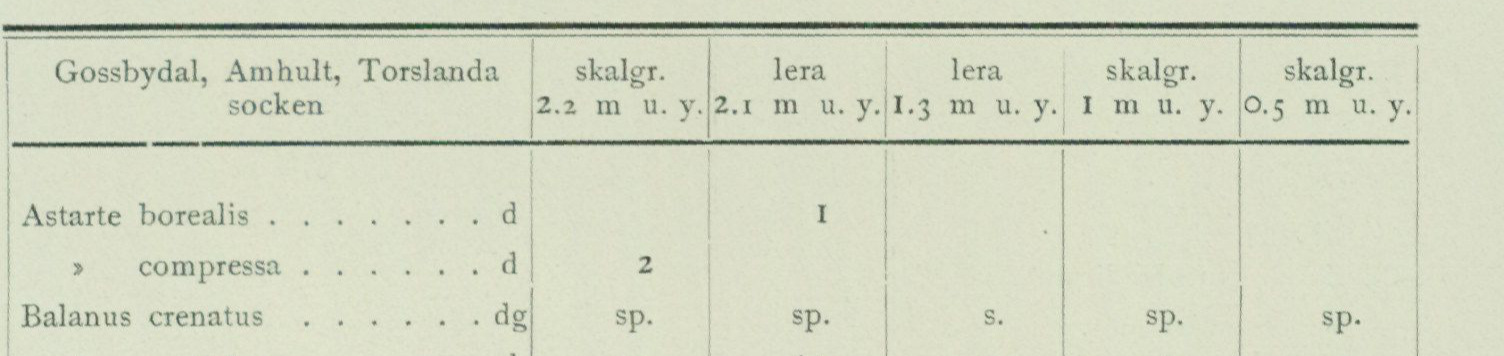
A gravel pit in the above-mentioned shell-gravel bank at Gossbydal near Amhult in Torslanda parish shows, according to a survey carried out by N. Odhner in 1922, the following stratigraphy:
A. 15 cm Sandy mould with worn and weathered shell fragments. B. 115 cm Shell gravel (samples taken 0.5 and 1 m below ground surface). C. 80 cm Shell-bearing clay (samples taken 1.3 and 2.1 m b. s.). D. 110 cm Shell gravel (sample taken 2.2 m b. s.). E. Bedrock.
The composition of the fauna in the various samples is shown in the table below. The letters d, g, dg after the species name denote deep-water species, shallow-water species, and those species that live in both deep and shallow water respectively (according to Antevs 1928). The frequency designations are: a = abundant, ta = fairly abundant, sp = sparse, s = rare. The figures denote — number of specimens in the case of gastropods and number of shell valves in the case of bivalves.
Gossbydal, Amhult, Torslanda shell gravel clay clay shell gravel shell gravel parish 2.2 m b. s. 2.1 m b. s. 1.3 m b. s. 1 m b. s. 0.5 m b. s. 7 1
Astarte borealis… d ! » compressa…d 2 Balanus crenatus… dg sp. sp. s. sp. sp. > porcatus…d a. ta. s. a. a. Boreoehiton marmoreus … dg 1 Buccinum groenlandicum … dg I 2 I fragm. 1 fragm. > undatum…d 1 Cingula castanea… d 4 6 1 Lacuna divaricata… g 1 Macoma calcaria… d 7 1 I Margarita cinerea… d I fragm. » groenlandica … . d 1 » helicina… d I Mya truncata…dg 4 1 8 2 2 Mytilus edulis… g 30 31 4 40 130 Pecten islandicus… d I fragm. 1 1 fragm. I fragm. Saxicava arctica… dg 190 49 586 202 357 Trophon clathratus…d 1
As appears from the table, it can hardly be said that any bathymetric changes can be read from it. Admittedly, the shallow-water species Mytilus shows a lower frequency in the clay 1.3 m below ground surface than in the overlying and underlying shell gravel, but on the other hand, the deep-water species Balanus porcatus also shows a consistently low frequency in the clay and high in the shell gravel.
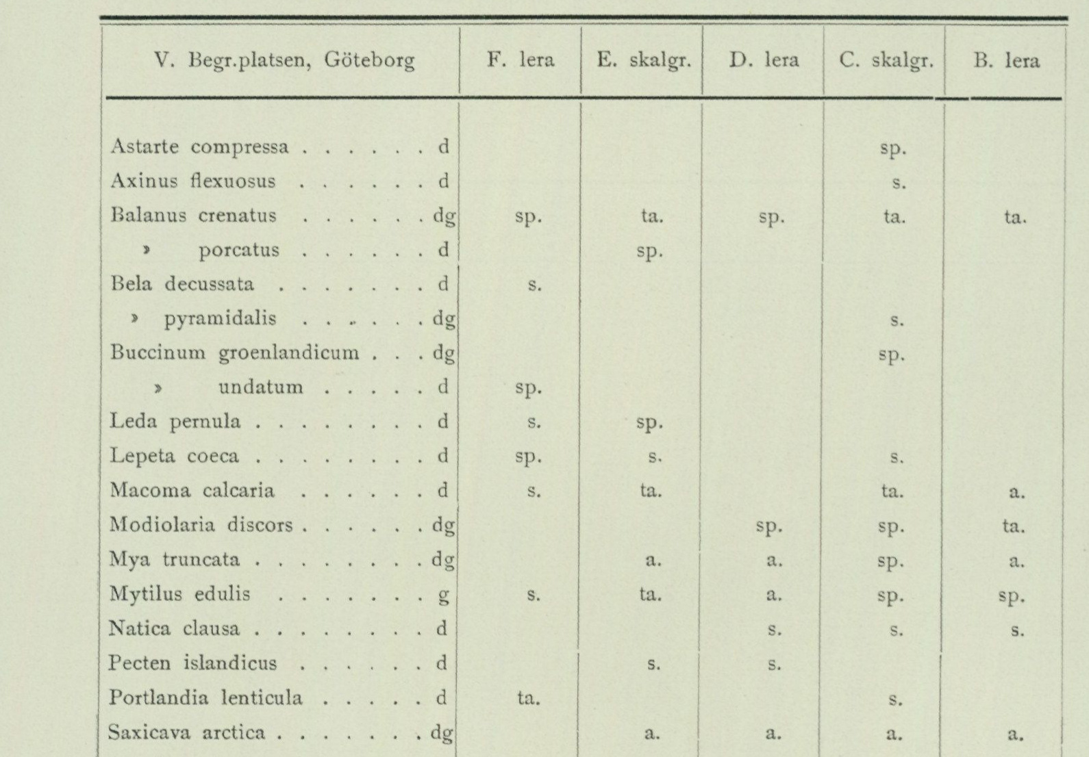
A profile measured in 1922 by N. Odhner through the shell-gravel bank N of V. Begravningsplatsen in Göteborg showed the following stratification:
A. ca. 5.0 m shell-free gravel and sand. B. 0.2 m shell-bearing clay. C. 0.3 m shell gravel. D. 0.4 m shell-bearing clay. E. 0.1 m shell gravel. F. 1.0 m shell-bearing clay. G. 1.0 m shell-free sand.
The table below shows the composition of the fauna in the various layers. The frequency designations have the same meaning as in the preceding table.
V. Begr.platsen, Göteborg F. clay E. shell gr. D. clay C. shell gr. B. clay
1 Astarte compressa… d sp. Axinus flexuosus…d s. ! Balanus crenatus… dg sp. ta. sp. ta. ta. > porcatus… d sp. Bela decussata… d s. » pyramidalis… dg s. Buccinum groenlandicum … dg sp. » undatum…d sp. i Leda pernula…d s. sp. Lepeta coeca…d sp. s. s. ! Macoma calcaria…d s. ta. ta. a. Modiolaria discors… dg sp. sp. ta. Mya truncata…dg a. a. sp. a. Mytilus edulis… g s. ta. a. sp. sp. Natica clausa…d s. s. s. Pecten islandicus… d s. s. Portlandia lenticula…d ta. s. Saxicava arctica… dg a. a. a. a. i Trophon clathratus…d s. s. Verruca stroemia… dg sp. sp.
Nor here does there appear to be any tendency for the deep-water species to show higher frequency in the clay than in the shell gravel, and the only shallow-water species, Mytilus, reaches its highest frequency in clay layer D.
A more comprehensive material of detail-investigated shell-gravel banks and shell-bearing clays from the Göteborg area and southern Bohuslän will be presented in a separate publication in Sveriges geologiska undersöknings årsbok, and therefore only a list of the occurrences will be given here of
of late-glacial shell-bearing clay within the Göteborg map sheet that have been more closely investigated during the geological fieldwork. However, for the interesting shell-bearing clay at Stekens tegelbruk in Angereds parish, a detailed account is given on pp. 126—128.
Late-glacial shell-bearing clays.
Torslanda parish.
Gossbydal, Amhult. Between two beds of shell gravel. 41.7 m a. s. l. 53 % of M. G. 14 species. The fauna gives no indication that the clay would have been deposited in deeper water than the underlying and overlying shell gravel (cf. p. 89). NW of Amhult. Beneath 0.7 m thick shell gravel. 36 m a. s. l. 45 % of M. G. 5 species. W of Hästevik. Beneath sand in the waterline at the shore. 3 species.
V. Frölunda parish.
SE of Tranered. ca. 500 m SE of the station. 25 m a. s. l. 29 % of M. G. 8 species¹. H ö g s b o. ca. 600 m SSE of the station. 20 m a. s. l. 22 % of M. G. 3 species. Tranered. NE immediately adjacent to the station. 16 m a. s. l. 19 % of M. G. 14 species¹. E c k r a n. ca. 300 m SSE of the farm. 13 m a. s. l. 15 % of M. G. 5 species. S of Tranered. ca. 500 m S of the station. 12 m a. s. l. 14 % of M. G. 10 species¹. Lundby parish. N of Bräck e. ca. 2100 m N of the farm beneath shore gravel, below the eastward-sloping rocky hill. 40 m a. s. l. 44 % of M. G. 11 species¹. A r d a 1. ca. 1 km N of the steamboat pier beneath 1.5 m shell gravel (see p. 84), 26 m a. s. l. 30 % of M. G. 18 species¹. Syrhåla. W of the farms beneath 1 m post-glacial shell gravel (see p. 102). 2.5 m a. s. l. 4 % of M. G. 17 species.
Göteborgs stad (excluding Lundby and Örgryte).
Tolltorpsdalen. ca. 800 m SE of Sahlgrenska sjukhuset. 65 m a. s. l. 68 % of M. G. 3 species¹. N of V. Begravningsplatsen. Interbedded with late-glacial shell gravel (see p. 84). 38 m a. s. l. 42 % of M. G. 14 species (species list p. 90). Änggårdsslätten. Beneath post-glacial shell-bearing clay (see pp. 94—95 and 107). 14.5 m a. s. l. 15 % of M. G. 5 species¹. E of F i s k h a m n e n. 1.5 m a. s. l. 2 % of M. G. 5 species¹. O 1 s k r o k e n. 1 m a. s. l. 1 % of M. G. 10 species. Gullbergsvass. Beneath post-glacial shell-bearing clay (see p. 108). 2 m b. s. l. 10 species. The river at Masthugget. 6 m b.s.l. 10 species.
Örgryte parish.
Kallebäck. ca. 600 m E of the farm. Beneath 1.5 m shore gravel on the southeastern slope of a rocky hill. 80 m a. s. l. 82 % of M. G. 5 species¹. The highest-elevated marine shell-bearing deposit in the map-sheet area. Härlandatj ärn. At the stream W of the tarn beneath peat and gravel. 50 m a. s. l. 50 % of M. G. 7 species.
1 Species list in »Göteborgstraktens geologi».
    Kärralund. By the stream in the valley E of the farm beneath 1 m beach gravel.  45 m
         a. s. l. 45 % of M. G.  7 species¹.

                                              Partilie parish.
    NW of U t b y. 80 m a. s. l. 77 % of M. G.  5 species.

                                     Björlanda parish.
       S of L i 11 e b y.  24 m a. s. l. 28 % of M. G.  8 species.
    V i k a n.  7 m a. s. l. 8 % of M. G.  6 species¹.

                                    Tuve parish.
    Skandia.  34.5 m a. s. l. 34 % of M. G.  23 species.  The clay is about 2 m thick,
        rests on bedrock and is overlain by 5 m of late-glacial shell gravel (see pp. 81—83).

                                  Backa parish.
    Bäckebol.  68.5 m a. s. l. 66 % of M. G.  17 species. Beneath late-glacial shell gravel
         (see p. 85).

                                    Angered parish.
     SSE of Assared.  Beneath 0.7 m peat about 900 m from the farm.  80 m a. s. l.
      77 % of M. G. 5 species.
    Steken's brickyard. ENE of Agnesberg railway station  (see  pp. 126
     —128).  35 m a. s. l. 33 % of M. G. 24 species.

                                      Säve parish.
     Österslätt. SE of the farms. 50 m a. s. l. 48 % of M. G.  6 species.

                                   Rödbo parish.
    Gödderöd. Beneath 2.5 m postglacial shell gravel (see p. 103). 17 m a. s. l. 15 %
     of M. G.  5 species.

                                      Torsby parish.
    Skottan. About 400 m E of the farms 50 m a. s. l. 50 % of M. G.  8 species.
    Hålisung.  About 1 km SE of the farms. 30 m a. s. l. 31 % of M. G. 9 species.
    Ranneberg.  By the main road NW of the farms.  18 m a. s. l. 18 % of M. G.
        7 species.
        V. Holm.  Beneath  2.1 m postglacial shell gravel (see pp. 104—106). 10 m a. s. l.
       11 % of M. G.  8 species (species list pp. 105—106).
Postglacial formations.
Level Once the area was relieved from the weight of the ice sheet, a land changes. uplift ensued, as described above, bringing about the late-glacial regression described in the preceding account. This progressed at least so far that, for example, a point at Änggården in Göteborg, which now lies 15.85 m a. s. l., came to lie at least at the level of the then sea surface. The late-glacial regression was succeeded by the postglacial transgression, which reached its maximum during the Stone Age, whereby the postglacial limit (P. G.) or the Tapes limit was formed. Within the Baltic Sea area this corresponds to the Litorina limit. P. G. lies at Göteborg about 26 m above the present sea surface (see below). After the postglacial transgression reached its maximum, the postglacial
¹ Species list in »The geology of the Göteborg area».
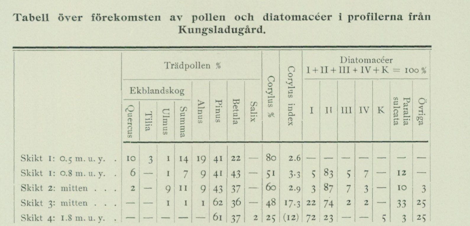
regression, which eventually led to the present distribution of land and water. An extraordinarily important piece of evidence that the shoreline displacements in the Göteborg area had the course indicated above is provided by two stratigraphic sequences located within the Göteborg city area, one at Kungsladugård and the other at Änggården.
The locality at Kungsladugård, situated 18.2 m a.s.l., came to attention when, during excavation work for the laying of sewer pipes, a stone axe (of type 347 in: Montelius, O. Minnen från vår forntid, Sthlm 1917) was encountered 1.2—1.4 m below the ground surface. The find was sent to the Göteborg Museum, and Johan Alin was commissioned to investigate the stratigraphic conditions at the site more closely. The sequence is, according to Alin, as follows:
- 0.8 m Clay, yellow.
- 0.45 m Sand, grey, fine.
- 0.45 m Clay, black, with plant fragments.
-
-
Clay, blue, with plant fragments.
-
The axe had been encountered at the boundary between layers 3 and 4. Samples collected by Alin were sent to the Geological Survey of Sweden, where they were subjected to detailed analysis by L. von Post regarding pollen and by B. Halden regarding diatoms. Regarding the results of these investigations, von Post has communicated the following:
Table: occurrence of pollen and diatoms in the profiles from Kungsladugård.
Tree-pollen columns are oak mixed forest (Quercus, Tilia, Ulmus, sum), Alnus, Pinus, Betula, and Salix, followed by Corylus % and the Corylus index. Diatom columns I + II + III + IV + K total 100%, followed by Paralia sulcata and other forms.
| Layer / depth | Quercus | Tilia | Ulmus | Oak-mixed sum | Alnus | Pinus | Betula | Salix | Corylus % | Corylus index | I | II | III | IV | K | Paralia sulcata | Other |
|---|---|---|---|---|---|---|---|---|---|---|---|---|---|---|---|---|---|
| Layer 1, 0.5 m below surface | 10 | 3 | 1 | 14 | 19 | 41 | 22 | — | 80 | 2.6 | — | — | — | — | — | — | — |
| Layer 1, 0.8 m below surface | 6 | — | 1 | 7 | 9 | 41 | 43 | — | 51 | 3.3 | 5 | 83 | 5 | 7 | — | 12 | — |
| Layer 2, middle | 2 | — | 9 | 11 | 9 | 43 | 37 | — | 60 | 2.9 | 3 | 87 | 7 | 3 | — | 10 | 3 |
| Layer 3, middle | — | — | 1 | 1 | 1 | 62 | 36 | — | 48 | 17.3 | 22 | 74 | 2 | 2 | — | 33 | 25 |
| Layer 4, 1.8 m below surface | — | — | — | — | — | 61 | 37 | 2 | 25 | (12) | 72 | 23 | — | — | 5 | 3 | 25 |
Diatom groups: I = bottom-dwelling forms (including freshwater species); II = epiphytes; III = deep-bottom forms; IV = plankton forms; K = clear-water lake forms (arenaria forms). Division after Halden (G.F.F. 1921, p. 514).
The pollen analyses indicate that all investigated samples originate from the period
before the maximum of the postglacial transgression. Samples 3 (in which the axe
is reported to have lain) and 4 show the high Corylus index (i.e. Corylus divided by
oak mixed forest + alder) characteristic of the oldest post-Arctic
of southwestern Sweden, and the series falls around the level at which this cha
racter ceases. This level has been dated to a fairly advanced
stage of the postglacial transgression (though not the final stage) as well
as archaeologically to the so-called bird-arrow period.
Both the stratigraphy itself and, even more so, the changes within the diatom
flora register an increasing water depth. Layers 4 and 3 are true
littoral deposits, which are overlain by deposits from the outer shore
zone (layer 2) and possibly the elittoral (layer 1).
The profile constitutes evidence of a postglacial transgression in the Göteborg area.
The axe belongs to the older Stone Age, probably before Ertebølle.
Änggården. The locality at Änggården was noted during works carried out by the Street and Road Administration of the Göteborg City Building Office. On the initiative of the building director F. Blidberg, a series of samples was collected, taken at every ½ meter below the ground surface down to a depth of 3.5 m, which together with a report on the conditions at the site were sent to the Geotechnical Commission of the Swedish State Railways, which in turn handed over the material to the Geological Survey of Sweden. According to the information appended to the samples by the acting works manager W. Huggert, the locality lies at 17.6 m a.s.l. and the sample series was collected at the place where this elevation figure is marked on the map. Furthermore, the depth to solid rock there is about 22 m, of which the uppermost about 20 m consist of clay. The stratigraphy is as follows. (Cf. fig. 35, where the upper part of the same is reproduced.)
     A. ca.   1.4 m Postglacial marine clay.
       B. ca.  0.25 m Sand, more or less gravelly.
       C. ca.  0.25 m Peat soil.
      D. ca.  18.0 m Clay.
       E. ca.   2.0 m Till gravel?
       F.           Rock.

      This stratigraphy, i.e. the layers of sand and peat soil between the two
       clay layers, has later been encountered at a number of localities in the vicinity, for
     example on the plot no. 8 in the block Lövkojan and at the corner of Apotekaregatan and
      Frölundagatan, which is why it is in all probability prevailing throughout the entire
          small clay plain between the Botanical Garden and Slottsskogsparken.
          Locally in the north, however, the peat layer wedges out, for example where excavation has been done for a
   pond at the Botanical Garden. The contact between the sand, which here is gravelly,
      and the underlying clay is there exceedingly sharp, and on the clay surface
        or in the basal layer of the sand fallen tree trunks have been encountered. Moreover,
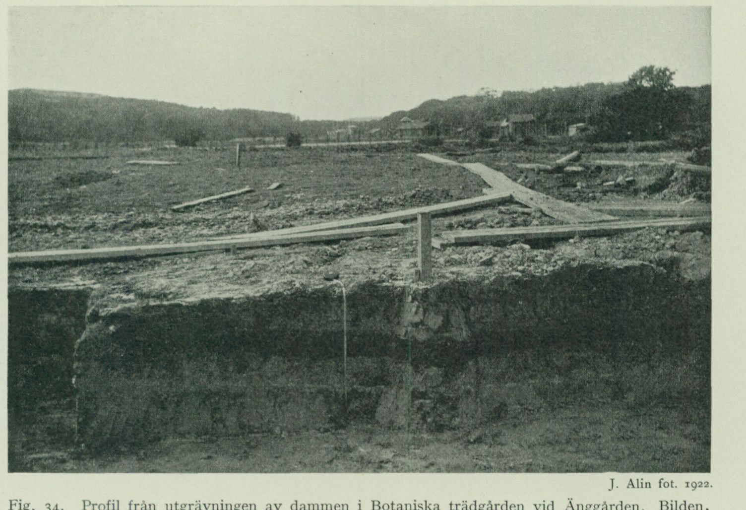
the lower clay shows a distinct weathering zone extending to a depth of 2 dm below the contact with the sand (old ground surface). Fig. 34. The depositional conditions here show that after the deposition of the lower clay (this is a shell-bearing late-glacial Yoldia clay, cf. above p. 91) regression had proceeded so far that the aforementioned plain was brought at least to sea level but probably still somewhat higher. Within the central, lowest-lying parts of the plain, the ground moisture was sufficiently great that peat formation occurred
J. Alin, photograph, 1922. Fig. 34. Profile from the excavation of the pond in the Botanical Garden at Änggården. The image, taken from the north, shows a gently westward-dipping sand layer (the dark layer in the image) overlain and underlain by clay. In the left (eastern) part of the section part of the upper clay has been scraped away for leveling of the ground surface.
on top of the clay, while the latter within the somewhat higher-lying parts, i.e. the margins of the plain nearest below the slopes of the surrounding heights, was subjected to a rather thorough soil weathering. Thereafter a transgression occurred, whereby first sand was washed down over both the old clay ground surface and the peat, and subsequently the upper clay was deposited. Both the sand and the clay, which within the southern part of the area is distinctly gyttja-bearing, contain marine diatoms, locally also shells of molluscs and foraminifera (see below p. 107), from which it follows that they were deposited in the postglacial sea. Through the postglacial regression the area was once again brought above sea level. How can one now date the shoreline changes registered in the stratigraphy at Änggården? A very important role in this regard is played by the study of the fossil tree pollen flora and its frequency shifts in the
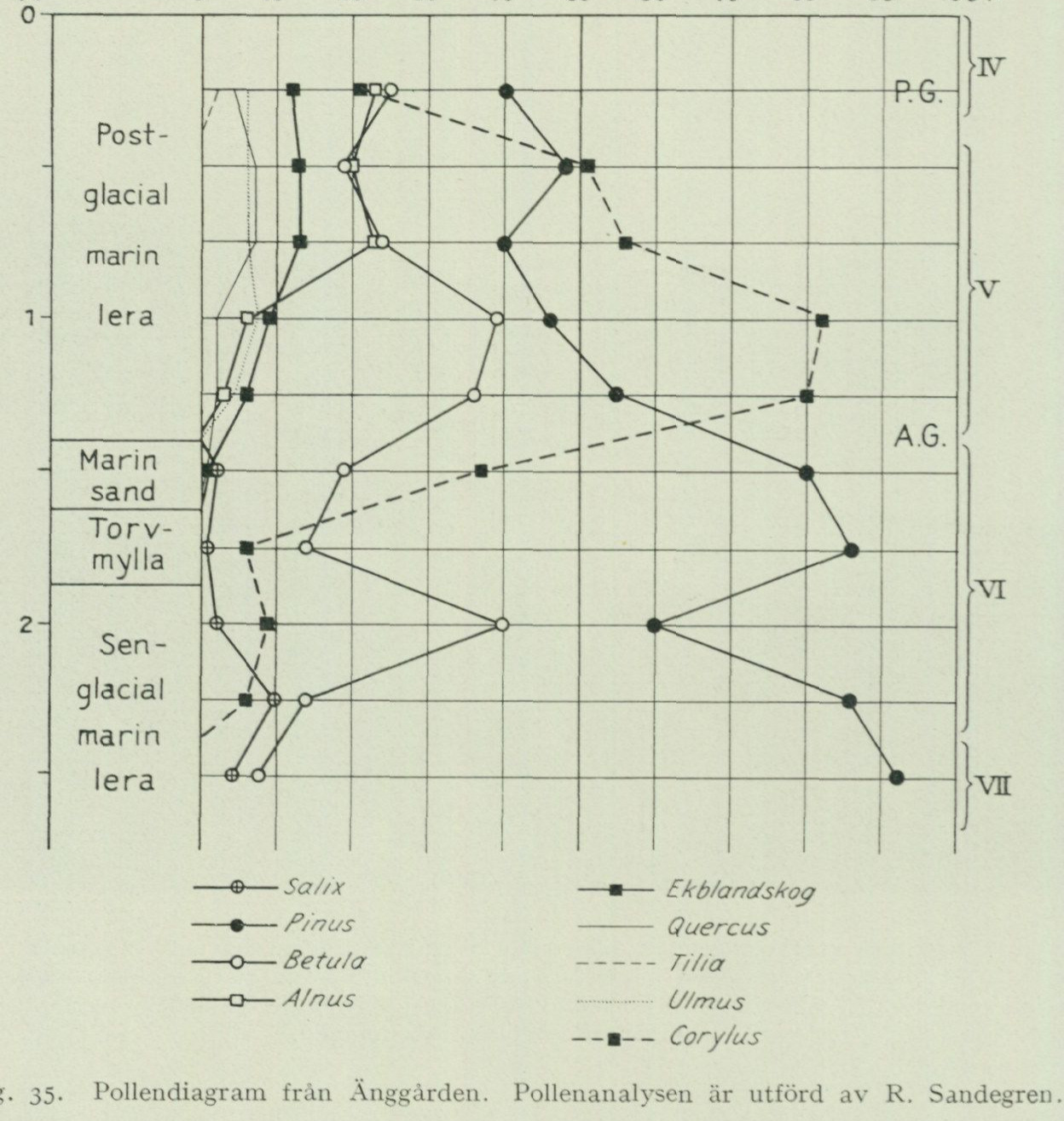
sequences.1 In their main features, these are similar throughout the whole of southern and central Sweden, and with the aid of diagrams compiled from them (fig. 35, 39 and 41—46) one can recognize certain zones and levels which, when placed in relation to the geological development (level changes etc.) and to archaeologically datable antiquities encountered in the sequences, make it possible to fit the phytogeographical development into both the geological and the archaeological chronology. Through this, the so-called pollen analysis method has become the best and most reliable means for correlation and age determination of postglacial sequences, while at the same time providing information about the immigration and changes of the plant world and about the climatic conditions that governed the development. Fig. 35. Pollen diagram from Änggården. The pollen analysis was carried out by R. Sandegren. Depth scale: 0–2.5 m. Sediment sequence, top to bottom: postglacial marine clay; marine sand; peat gyttja; late-glacial marine clay. Curves: Salix, Pinus, Betula, Alnus, oak mixed forest, Quercus, Tilia, Ulmus, and Corylus. Marked boundaries: P.G. (postglacial boundary) and A.G. (Arctic boundary); pollen zones IV, V, VI, and VII.
Fig. 35 is a pollen diagram of the above-mentioned sample series from Änggården, collected by the Göteborg Building Office. The agreement with
1 von Post, Lennart, Skogsträdpollen i sydsvenska torvmosslagerföljder. Geol. Fören. Förh.
Bd. 38, H. 6, 1916 och Forh. ved 16 skand. naturforskermöte 1916. von Post, Lennart, Ur de sydsvenska skogarnas regionala historia under postarktisk tid. Geol. Fören. Förh. Bd. 46, 1924.
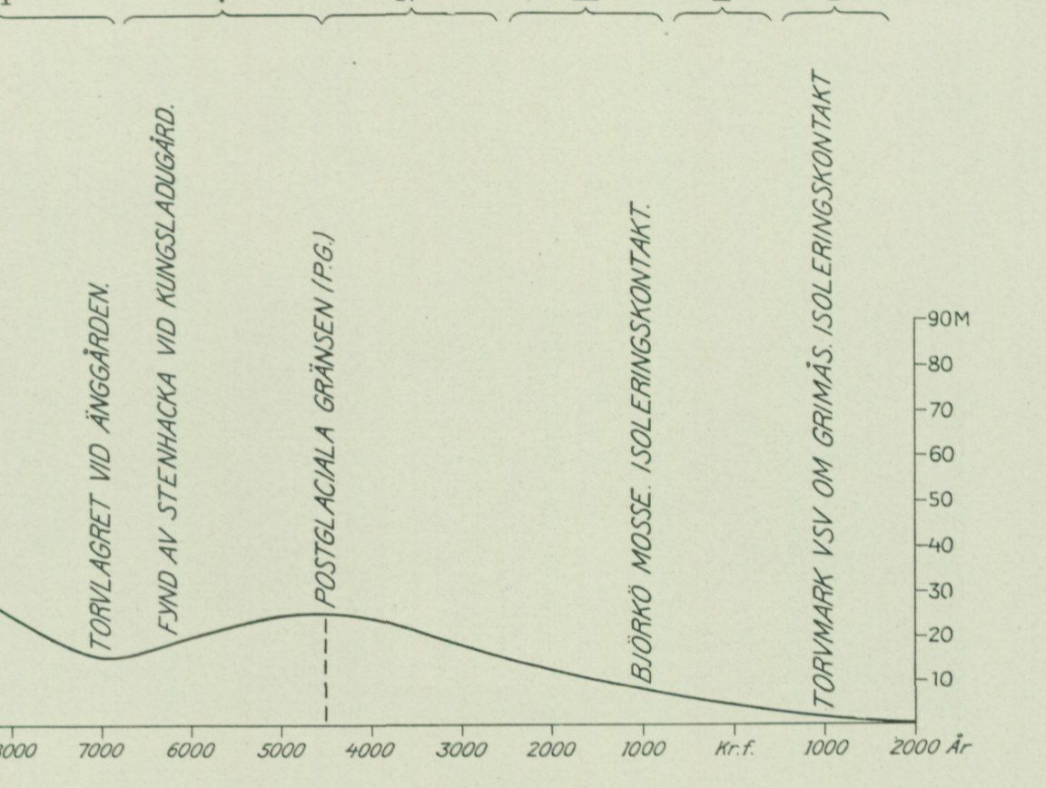
the table from Kungsladugård given on p. 93 is striking. The sequences were formed simultaneously and as a consequence of the same phenomenon, the postglacial transgression. The late-glacial regression had, as the consistent testimony of the sequences at Kungsladugård and Änggården shows, at a very early stage of postglacial time, already before the immigration of the noble deciduous trees, brought the level, which at these localities now lies at approx. 16 m a.s.l., at least down to
vir vi v w m H 1
Years: 11,000, 10,000, 9,000, 8,000, 7,000, 6,000, and 5,000 BC; then 4,000, 3,000, 2,000, and 1,000 BC; birth of Christ; AD 1,000 and AD 2,000. Vertical scale: 0–90 m above present sea level. Pollen zones at the upper edge: VII, VI, V, IV, III, II, I. Source callouts on the curve: peat layer at Änggården; stone-axe find at Kungsladugård; postglacial boundary (P.G.); Björkö moss bog, isolation contact; peatland WSW of Grimås, isolation contact.
Fig. 36. Displacement of the shoreline in the Göteborg area from the time of the formation of the highest marine limit to the present day. At the lower edge: millennia before and after the birth of Christ. Vertically: height in metres above present sea level. At the upper edge: the pollen-analytically distinguished zones (cf. below pp. 133—137). Furthermore, the most important facts underlying the construction of the curve have been indicated.
sea level. Subsequently, the postglacial transgression ensued, which reached these localities at a stage that, as mentioned above, falls before Epipalaeolithic time (cf. schematic p. 134). The level changes in the Göteborg area are most clearly illustrated by the above fig. 36, where the curve shows the displacement of the shore from the time of the formation of the highest marine limit to the present day.
Postglacial marine formations.
The postglacial boundary marks, as emphasized above, the position of Postglacial the shoreline at the time of the postglacial transgression maximum. Within boundary. the Göteborg sheet this boundary rises from approx. 22 m in the far SW to approx. 28 m in the far NE. A map showing the course of the P.G. isobases within the Göteborg area and southern Bohuslän is found in the above-cited work »Göteborgs traktens geologi» (p. 248 resp. 150).
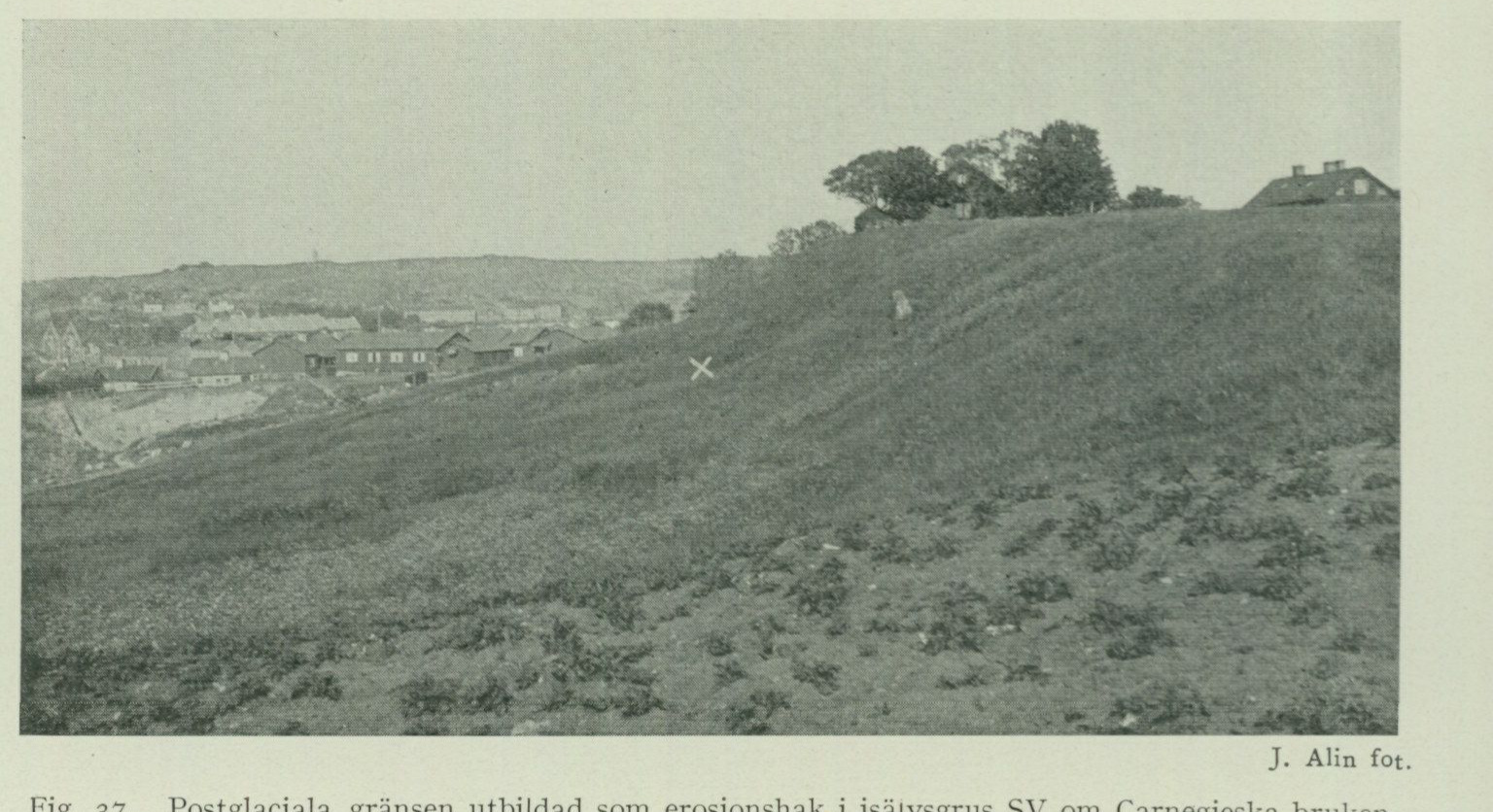
For the localities situated within the map-sheet area where the postglacial boundary has been determined, a brief account is given here. N. Hästevik, Torslanda parish. Ridge of coarse shingle in a south-westward-facing slope W of the farmsteads, 23.5 m a.s.l. Further down in the same slope (12.5 m a.s.l.) is the postglacial shell-gravel bank W of Hästevik mentioned on p. 102. Rörö, Öckerö parish. Ridge of coarse shingle in the centrally located valley on the island W of Apelvik, 25 m a.s.l. Immediately S of the ridge lies, as
.
J. Alin, photograph.
Fig. 37. The postglacial boundary developed as an erosion notch in glaciofluvial gravel SW of Carnegieska bruken, Göteborg. The notch itself, 25.5 m a.s.l., marked by a white x.
a distal shore-gravel accumulation in direct connection to this, the postglacial shell-gravel bank mentioned on p. 101 and 131, 21.7 m a.s.l., the highest postglacial shell-gravel bank in the area. Ardal, Lundby parish. Shore ridge approx. 1 km N of the steamboat pier. The ridge has a length of approx. 70 m and extends from SSW towards NNE between three bedrock outcrops. It consists, in the SSW, where it reaches up to 25 m a.s.l., of rather coarse shore gravel, and in the NNE of fine sand. The crest of the ridge lies at 24.7 m a.s.l. From this decrease towards NNE of both the grain size of the material and the height of the ridge crest, it is evident that the ridge was built up in the form of a spit by waves and shore currents approaching from S, that is to say from the Älvsborgsfjorden. Immediately above the ridge lies a Stone Age settlement from the Ertebølle period, and somewhat farther W the late-glacial shell-gravel bank mentioned on p. 84, 33 m a.s.l. Carnegieska bruket, Göteborg. Erosion notch in glaciofluvial gravel SW adjacent to the works and above the large gravel pit, 25.5 m a.s.l. (Fig. 37.) The notch itself is marked on the figure with a white x. The surface of the glaciofluvial gravel above it, on which the houses visible on the right in the image are situated, reaches up to 33 m a.s.l.

Bagaregården, Göteborg. Erosion scarp in till on the western side of the hill at 25.9 m a. s. l. The scarp runs approximately parallel to Uddevallagatan, E close to the latter from the corner of Falkgatan and S, and in it lie some rather large wave-polished boulders. Redbergsparken, Göteborg. Erosion scarp on the western side of the hill, immediately S of the schoolhouse, 26 m a. s. l. Kyrkåsen, Göteborg. On the western side of the large end moraine E of Olskrokens station there was an erosion scarp cut into it, 26 m a. s. l. This is, however, now largely destroyed. Landerigatan runs partly along the narrow terrace flat that has formed immediately below the actual scarp. Lärje station, Göteborg. Erosion scarp in the western slope of the end moraine, E of the marshalling yard, 26.5 m a. s. l. A circumstance of great interest, which is suited to elucidate certain conditions during the formation of the postglacial limit, has emerged through the study of the shell-bearing marine deposits of the Göteborg area. Upon a purely statistical treatment of the elevation of the investigated deposits, expressed in % of M. G., these show the distribution that appears from the table below, where the figures indicate the number of occurrences encountered at different levels.
| % of M. G. | Shell-bearing clays | Shell gravel banks |
|---|---|---|
| 85—90 | 1 | |
| 80—85 | 1 | |
| 75—80 | 2 | |
| 70—75 | 3 | |
| 65—70 | 2 | 4 |
| 60—65 | 9 | |
| 55—60 | 9 | |
| 50—55 | 1 | 11 |
| 45—50 | 3 | 6 |
| 40—45 | 6 | 11 |
| 35—40 | 7 | |
| 30—35 | 4 | 8 |
| 25—30 | 7 | |
| 20—25 | 2 | |
| 15—20 | 6 | 11 |
| 10—15 | 6 | 10 |
| 5—10 | 7 | 18 |
| 0—5 | 18 | 16 |
| Total | 64 | 143 |
From the table it appears, partly the downward decreasing frequency of the deposits in question, partly that not a single shell gravel bank has been encountered at the level between 20 and 25 %
by M. G. From this level only two occurrences of shell-bearing
clay are known, both situated in remarkably well-sheltered positions and containing
a species-poor late-glacial fauna (Astarte compressa, A. elliptica, Balanus crena-
tus, Macoma calcaria, Mya truncata, Mytilus edulis, Saxicava arctica).
The reason for this circumstance appears to be that the postglacial limit
falls within the aforementioned level zone. At the turning point between transgression and re
gression, the shoreline was evidently relatively stationary for a sufficiently long time that
wave action managed to erode away the loose deposits more effectively than during any other phase. The phenomenon is a fact which, in the same way as the previously cited topographical and stratigraphical conditions, sup
ports the view presented in this description regarding the mode of formation of the shell gravel banks.
Beach gravel Postglacial beach gravel and sand is encountered partly at the postglacial and sand. limit itself, where this is developed as beach ridges, and partly below it at all such localities where gravelly or sandy material was available for reworking through wave action during postglacial time. On slopes and around protruding elevations, therefore, as is apparent from the map, sand and gravel deposits frequently occur, whereas the central parts of the larger plains always consist of clay. The abundant sand that extends across the area around Bräcke, Färjenäs, Lundby nya kyrka and Västra begravningsplatsen, or on Hönö and Öckerö, has thus been washed out from the zones of cross-ridges and end moraines that pass through there. This postglacial sand, which nearest to the elevations composed of rock, till or glaciofluvial gravel transitions into more or less coarse beach gravel of a couple of metres’ thickness, is generally at some distance from the elevations only 1—0.5 m thick and rests on clay. Farther away it gradually thins out ever more and finally pinches out, so that the clay is exposed at the surface. Within the areas designated as sand on the map, it may also thin out further, or be entirely absent in patches. Such is the case, for example, within some small areas in Rya skog and N thereof that cannot be represented on the map. At several localities on Hisingen it has been observed that the clay underlying the sand is of late-glacial age. In the shore cliff towards Älvsborgsfjorden at the open-air playground Ö next to Rya nabb, for example, one thus sees 1 m sand overlying stiff blue-grey glacial marine clay. Occasionally one finds that the con tact between the sand and the glacial marine clay displays an irregular course, in that the sand fills hollows or actually channels in the clay, and moreover the contact is often paved with a thin layer of coarser gravel with scattered larger stones. Both these channels and the stone or gravel paving at the contact between the clay and the sand are attributable to erosion that took place, in the former case through running water, in the latter through wave action, during the time before the postglacial transgression, when the shoreline lay lower than later. Among localities displaying such stratigraphical sequences, the following may be cited. About 600 m N of Halvordsäng in Björlanda parish, at an elevation of about 25 m a.s.l., thus approximately at or just below P. G., the summer of 1922 showed
a newly dug ditch about 1 m sand resting on stiff glacial marine clay. The contact between the clay and the sand had an uneven, undulating course with about 0.5 m of elevation difference and 1—5 m of horizontal distance between hollows and mounds. The ground surface is smooth, gently sloping towards S. On the smooth field about 300 m S thereof, at an elevation of about 12 m a.s.l., another ditch showed the following stratigraphical sequence. A. 0.5 m S a n d. B. 1.5 m -j- Glacial marine clay, stiff, blue-grey.
The sharp contact between the sand and the clay was paved with walnut-sized stones, among which flint also occurred. WNW of Tingstad, or more precisely 500 m ENE of the intersection between the Bohus railway and the public road, a likewise newly cleaned ditch between the road and the rock in the W showed, at an elevation of about 10 m a.s.l., conditions of stratification entirely similar to those described above N of Halvordsäng:
A. 0.5 m S a n d B. Stiff glacial marine clay.
The contact between the sand and the clay was sharp, and the upper surface of the clay had similar depressions filled with sand. A couple of such depressions, which were measured, were about 1 m wide and 0.5 m deep.
The postglacial sand and beach gravel deposits contain, like the Shell gravel senglacial ones, very often shells of molluscs and other marine organisms. banks. Thus, numerous postglacial shell gravel banks occur within the map sheet, formed in the same way as the late-glacial banks described above, but during the postglacial regression. Below is provided a list of the postglacial shell gravel banks within the map sheet area that have been more closely examined during the geological fieldwork.
Postglacial shell gravel banks.
Öckerö parish.
W of Apelvik, Rörö. Distal beach gravel associated with the post glacial limit ridge. 21.7 m a.s.l. 29 % of M. G. 88 % of P. G. 35 species. The highest-situated postglacial shell gravel bank in the map sheet area. See p. 131. Björkö huvud. In a depression in the rock. 12.7 m a.s.l. 16 % of M. G. 54 % of P. G. 22 species. K a l v ö. In a depression in the rock on the northern part of the island. 10 m a.s.l. 14 % of M. G. 43 % of P. G. 38 species. Brätten, Öckerö. 7.5 m a.s.l. 11 % of M. G. 35 % of P. G. 22 species. Björkö mosse. Near the southern tip of Björkö. Accumulation terrace 7 m a.s.l. 9 % of M. G. 30 % of P. G. 33 species (species list p. 124). The pollen diagram, fig. 45, shows that the clay resting on the distal part of the bank was deposited during the last regression after the maximum of the postglacial transgression and thus in shallower water than the shell gravel.
Ö c k e r ö gamla kyrka. 4.5 m a.s.l. 7 % of M. G. 22 % of P. G. 34 species. Ryd, Björkö. 5 m a.s.l. 6 % of M. G. 21 % of P. G. 33 species (see p. 107). W of Ryd. Valley fill near the shore on the western side of the northern part of Björkö. 3 m a.s.l. 4 % of M. G. 13 % of P. G. 40 species. Apelvik, Rörö, 2.7 m a.s.l. 4 % of M. G. 12 % of P. G. 41 species. Norra Öckerö. At the eastern shore approx. 1 km N of Brätten. 2 m a.s.l. 3 % of M. G. 9 % of P. G. 30 species. E of Hönö Klåva. Approx. 1 km E of the settlement. 2 m a.s.l. 3 % of M. G. 9 % of P. G. 15 species. Hönö Klåva. E immediately adjacent to the settlement. 1 m a.s.l. 1 % of M. G. 5 % of P. G. 47 species. F o t ö. Valley fill on the middle part of the island between the bays projecting from N and from S. 1 m a.s.l. 1 % of M. G. 5 % of P. G. 25 species.
Torslanda parish.
E of Hästevik. In a pocket-shaped depression in a westward-facing rock slope. 16 m a.s.l. 20 % of M. G. 67 % of P. G. 44 species. W of Hästevik. In a pocket-shaped depression in a rock slope. 12.4 m a.s.l. 16 % of M. G. 50 % of P. G. 35 species. N of Hästevik. Valley fill at the highest threshold of the valley that extends from Hästevik N out to the shore. 10 m a.s.l. 13 % of M. G. 42 % of P. G. 35 species. H j u v i k. Valley fill SE of the steamboat pier. 5 m a.s.l. 6 % of M. G. 22 % of P. G. 53 species. Hällsvik. Valley fill. 5 m a.s.l. 6 % of M. G. 21 % of P. G. 38 species. Sandvik. Valley fill approx. 500 m WSW of the cottages. 1.5 m a.s.l. 2 % of M. G. 8 % of P. G. 45 species. Amhultsholmen. On the W side of the islet below the rock slope. 1 m a.s.l. 1 % of M. G. 4 % of P. G. 18 species.
V. Frölunda parish.
Hinsholmen. Immediately below a steep rock slope. 2 m a.s.l. 2 % of M. G. 8 % of P. G. 30 species (species list in »Göteborgstraktens geologi»).
Lundby parish.
N of Häröd. Valley fill approx. 400 m from the farms. 10 m a.s.l. 11 % of M. G. 40 % of P. G. 21 species (species list in »Göteborgstraktens geologi»). NNE of Syrhåla. Valley fill approx. 800 m from the farms. 5 m a.s.l. 6 % of M. G. 20 % of P. G. 19 species (species list in »Göteborgstraktens geologi»). Synnered. Valley fill at the highest threshold in a narrow valley approx. 1 km N of the steamboat pier. 5 m a.s.l. 6 % of M. G. 20 % of P. G. 42 species (species list in »Göteborgstraktens geologi»). S y r h å l a. Accumulation terrace below a rock cliff W of the farms. 3.5 m a.s.l. 5 % of M. G. 16 % of P. G. 11 species. Underlain by late-glacial shell- bearing clay (see p. 91).
Göteborgs stad (excluding Lundby and Örgryte).
F i s k h a m n e n. 0 m a.s.l. 30 species. With interbedded shell-bearing clay (see p. 108, species list in »Göteborgstraktens geologi»).
Björlanda parish.
Fågelvik. Valley fill at the highest threshold in an east–west-trending valley approx. 1 km WNW of the farms. 8.4 m a.s.l. 9 % of M. G. 32 % of P. G. 37 species.
Backa parish.
Lillhagen. Accumulation terrace below a rock slope immediately N of the railway station. 6 m a.s.l. 6 % of M. G. 23 % of P. G. 36 species.
Säve parish.
Öxnäs. Accumulation terrace in a rock slope. 12.5 m a.s.l. 12 % of M. G. 50 % of P. G. 16 species. Öxnäs. Accumulation terrace below a rock cliff. 5 m a.s.l. 5 % of M. G. 19 % of P. G. 21 species. Rödbo parish. Gödderöd. Accumulation terrace 19.3 m a.s.l. 17 % of M. G. 68 % of P. G. 22 species. Underlain by late-glacial shell-bearing clay (see p. 92). E 1 1 e s b o. Accumulation terrace below the eastern slope of the esker approx. 600 m N of the farm. 6.6 m a.s.l. 6 % of M. G. 25 % of P. G. 14 species.
Nödinge parish.
Surte prästgård. Accumulation terrace below a rock. 10 m a.s.l. 9 % of M. G. 36 % of P. G. 9 species.
Harestads parish.
F 1 a t e b y. Accumulation terrace below a rock SW of the farms. 10 m a.s.l. 10 % of M. G. 38 % of P. G. 12 species.
Torsby parish.
Åkershög. In a depression in the rock approx. 600 m N of the farm. 18 m a.s.l. 20 % of M. G. 69 % of P. G. 35 species. St. Röd. Valley fill approx. 500 m SE of the farms. 15 m a.s.l. 16 % of M. G. 58 % of P. G. 14 species. V. H o 1 m. Accumulation terrace approx. 400 m W of the farm. 12 m a.s.l. 13 % of M. G. 46 % of P. G. 69 species (species list pp. 105—106). Underlain by late-glacial shell-bearing clay (see p. 92). Åkershög. Valley fill approx. 300 m W of the farm. 8 m a.s.l. 9 % of M. G. 31 % of P. G. 28 species. St. Röd. Accumulation terrace approx. 200 m SE of the farms. 5 m a.s.l. 5 % of M. G. 19 % of P. G. 21 species.
The postglacial marine clay naturally occurs only within areas Postglacial marine clay. situated below the postglacial limit. In many cases, especially in connection with protruding heights, it is overlain by postglacial shore gravel and sand, which during the last regression were washed down from the heights. The postglacial marine clay is thus exposed at the surface mainly only within the central parts of low-lying valleys and plains such as the Göta älv valley, the Kvillebäcken valley, and the plain within Säve parish, Änggårdsslätten, etc. It generally has a blue-grey colour in rather darker than lighter shades depending on the content of organic material incorporated within it. After drying, this clay, especially in its upper parts, is usually noticeably lighter than the late-glacial clay, owing to the abundantly occurring gyttja constituents, diatoms¹ etc. within it. Sometimes the clay
¹ A sample of postglacial clay taken 40 cm below the ground surface next to the brook approx. 1 km NW of Sör-
röd in Björlanda parish, was found upon a quick examination in the microscope to contain the following dia- toms: Coscinodiscus sp. Diploneis didyma, Epithemia musculus, Grammatophom sp. Hyalodiscus scoticus, Paralia sulcata, Rhabdonema sp.
thereby taking on the character of clay-gyttja. The postglacial marine clay generally does not attain any great thickness, usually only one to a couple of metres, see fig. 35 and 46. It is often encountered as the immediate substratum beneath postglacial shell-gravel banks, but equally often it overlies the shell gravel, at least within the distal portions of the banks. Sometimes postglacial clay is also found between two beds of shell gravel. Such clay is regarded by Antevs in his above-cited works as having been deposited during the maximum of the postglacial transgression. Below, a couple of localities within the Göteborg map sheet will be described, where postglacial clay is interbedded with shell gravel, and which are of interest for elucidating this question.
The above-mentioned shell-gravel bank, located c. 400 m W of V. Holm in Torsby parish, shows, according to a survey carried out by O. Claesson in the summer of 1923, the following stratigraphy:
In the central part of the bank (ground surface 12 m a.s.l.). A. 0.25 m shell-free sand, from which small weathering veins extend down into the underlying shell gravel. B. 0.60 m shell gravel (samples 1, 2 and 3, from the top, in the middle, and at the bottom of the layer, respectively; see table below). The lower boundary of the layer is marked by a thin horizon containing masses of large specimens of Litorina litorea, which could be followed parallel to the bank’s slope towards the E up to the pinch-out of the clay layer (C) appearing there, whereby its position in the stratigraphic sequence could be established. D. 1.25 m shell gravel (samples 4, 5 and 6 from the upper, middle, and lower parts of the layer, respectively). E. Shell-bearing late-glacial clay (sample 7).
In the eastern distal part of the bank (ground surface 11.15 m a.s.l.). A and B. 0.5 m sand and shell gravel (sample 8 of the shell gravel). C. 0.2 m shell-free postglacial clay with the following pollen flora: Pinus 67 %, Betula 12 %, Alnus 16 %, Quercus 2 %, Tilia 3 % (Corylus 6.5 %). D. Shell gravel.
The composition of the fauna in the various samples is shown in the table below. d = deep-water species, g = shallow-water species, dg = species living in both deep and shallow water (according to Antevs 1928). Frequency designations: y = abundant, r = common, the numbers indicate the number of specimens for gastropods, the number of shell valves for bivalves, and loose shell fragments for barnacles.
The pollen flora in the postglacial clay (layer C) shows that the layer in question is younger than the maximum of the postglacial transgression and is probably referable to the upper part of zone IV of the pollen diagrams (see below). The high Pinus frequency is presumably due to the locality’s position far out in the contemporary archipelago, whereby pine pollen, owing to its greater ability to remain airborne for a long time, attains a relatively higher frequency than at localities situated farther inland, as a result of which the frequencies of the other species’
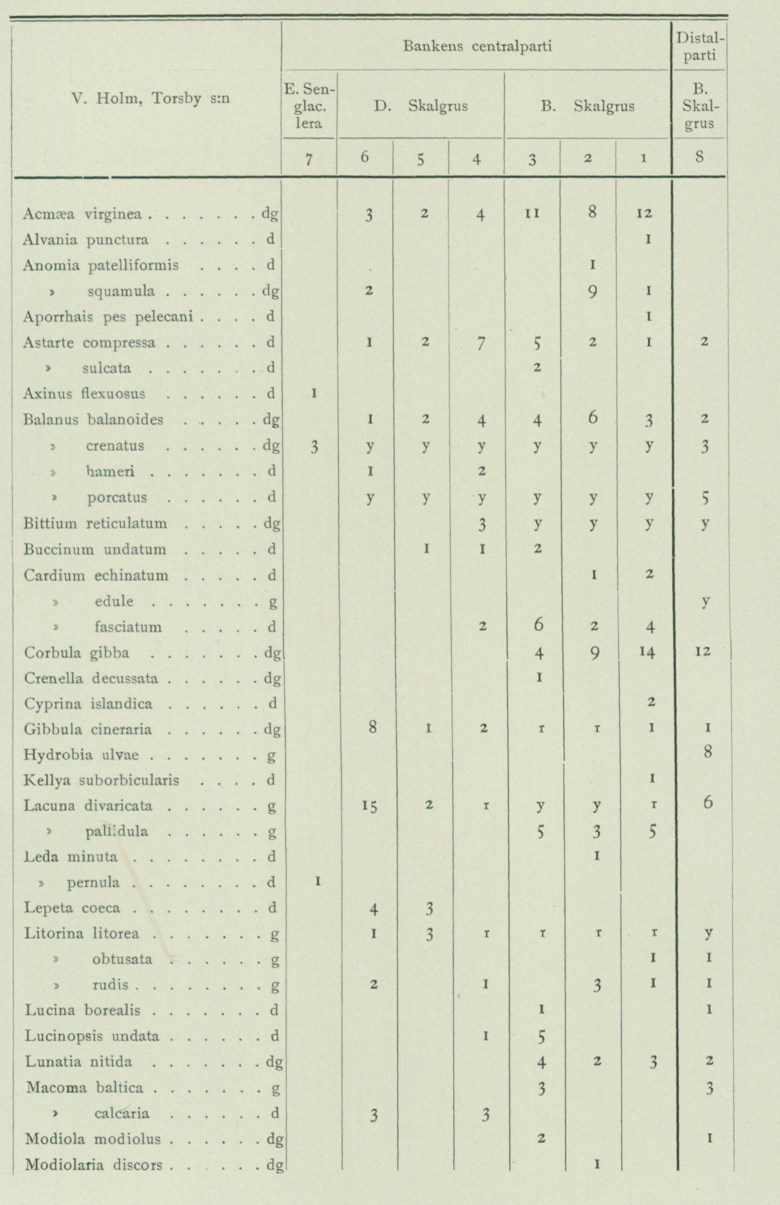
Faunal composition of samples from the shell-gravel bank west of V. Holm, Torsby parish (continued on p. 106). The source table is retained as the authoritative spatial facsimile. Column geometry: central part of the bank — E, late-glacial clay (sample 7); D, shell gravel (samples 6, 5, 4); B, shell gravel (samples 3, 2, 1); distal part — B, shell gravel (sample 8). Codes: d = deep-water species; g = shallow-water species; dg = both; y = abundant; r = common. Blank cells are blank in the source.
| Species | Habitat | 7 | 6 | 5 | 4 | 3 | 2 | 1 | 8 |
|---|---|---|---|---|---|---|---|---|---|
| Acmaea virginea | dg | 3 | 2 | 4 | 11 | 8 | 12 | ||
| Alvania punctura | d | 1 | |||||||
| Anomia patelliformis | d | 1 | |||||||
| Anomia squamula | dg | 2 | 9 | 1 | |||||
| Aporrhais pes pelecani | d | 1 | |||||||
| Astarte compressa | d | 1 | 2 | 7 | 5 | 2 | 1 | 2 | |
| Astarte sulcata | d | 2 | |||||||
| Axinus flexuosus | d | 1 | |||||||
| Balanus balanoides | dg | 1 | 2 | 4 | 4 | 6 | 3 | 2 | |
| Balanus crenatus | dg | 3 | y | y | y | y | y | y | 3 |
| Balanus hameri | d | 1 | 2 | ||||||
| Balanus porcatus | d | y | y | y | y | y | y | 5 | |
| Bittium reticulatum | dg | 3 | y | y | y | y | |||
| Buccinum undatum | d | 1 | 1 | 2 | |||||
| Cardium echinatum | d | 1 | 2 | ||||||
| Cardium edule | g | y | |||||||
| Cardium fasciatum | d | 2 | 6 | 2 | 4 | ||||
| Corbula gibba | dg | 4 | 9 | 14 | 12 | ||||
| Crenella decussata | dg | 1 | |||||||
| Cyprina islandica | d | 2 | |||||||
| Gibbula cineraria | dg | 8 | 1 | 2 | r | r | 1 | 1 | |
| Hydrobia ulvae | g | 8 | |||||||
| Kellya suborbicularis | d | 1 | |||||||
| Lacuna divaricata | g | 15 | 2 | 1 | y | y | r | 6 | |
| Lacuna pallidula | g | 5 | 3 | 5 | |||||
| Leda minuta | d | 1 | |||||||
| Leda pernula | d | 1 | |||||||
| Lepeta coeca | d | 4 | 3 | ||||||
| Litorina litorea | g | 1 | 3 | r | r | r | r | y | |
| Litorina obtusata | g | 1 | 1 | ||||||
| Litorina rudis | g | 2 | 1 | 3 | 1 | 1 | |||
| Lucina borealis | d | 1 | 1 | ||||||
| Lucinopsis undata | d | 1 | 5 | ||||||
| Lunatia nitida | dg | 4 | 2 | 3 | 2 | ||||
| Macoma baltica | g | 3 | 3 | ||||||
| Macoma calcaria | d | 3 | 3 | ||||||
| Modiola modiolus | dg | 2 | 1 | ||||||
| Modiolaria discors | dg | 1 |
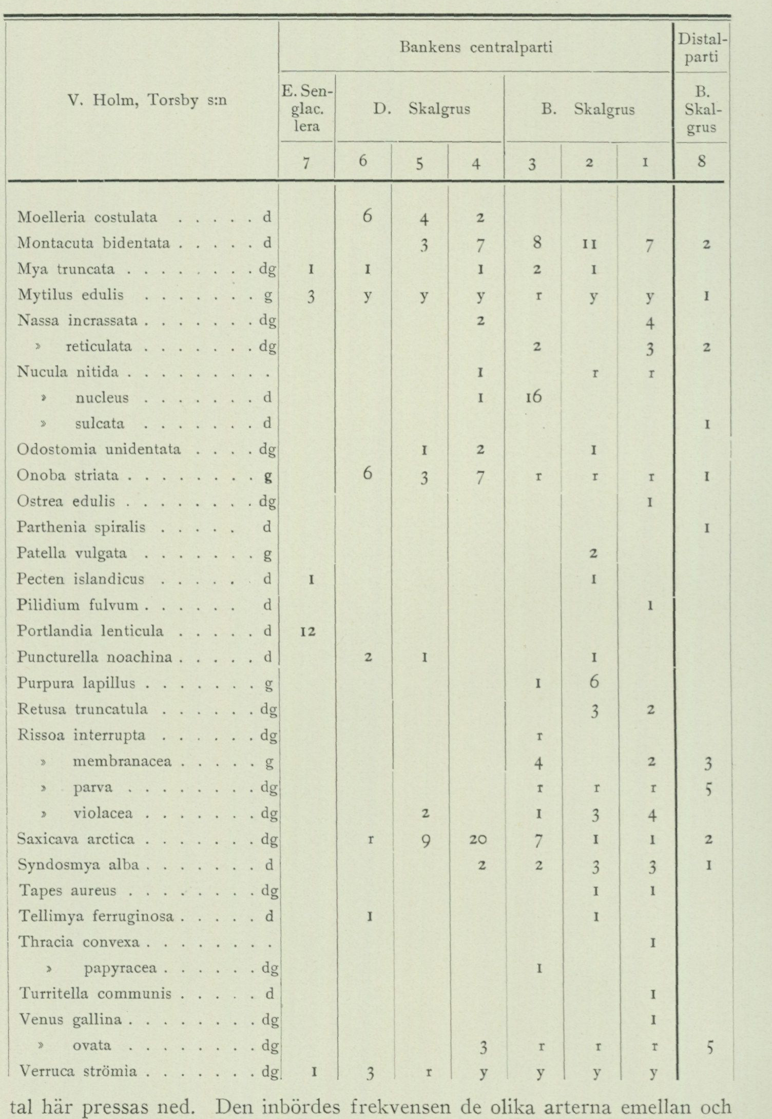
Faunal composition of samples from the shell-gravel bank west of V. Holm, Torsby parish (continued). Column geometry is unchanged from p. 105: sample 7; samples 6, 5, 4; samples 3, 2, 1; sample 8. Blank cells are blank in the source facsimile.
| Species | Habitat | 7 | 6 | 5 | 4 | 3 | 2 | 1 | 8 |
|---|---|---|---|---|---|---|---|---|---|
| Moelleria costulata | d | 6 | 4 | 2 | |||||
| Montacuta bidentata | d | 3 | 7 | 8 | 11 | 7 | 2 | ||
| Mya truncata | dg | 1 | 1 | 1 | 2 | 1 | |||
| Mytilus edulis | g | 3 | y | y | y | r | y | y | 1 |
| Nassa incrassata | dg | 2 | 4 | ||||||
| Nassa reticulata | dg | 2 | 3 | 2 | |||||
| Nucula nitida | [not printed] | 1 | r | r | |||||
| Nucula nucleus | d | 1 | 16 | ||||||
| Nucula sulcata | d | 1 | |||||||
| Odostomia unidentata | dg | 1 | 2 | 1 | |||||
| Onoba striata | g | 6 | 3 | 7 | r | r | r | 1 | |
| Ostrea edulis | dg | 1 | |||||||
| Parthenia spiralis | d | 1 | |||||||
| Patella vulgata | g | 2 | |||||||
| Pecten islandicus | d | 1 | 1 | ||||||
| Pilidium fulvum | d | 1 | |||||||
| Portlandia lenticula | d | 12 | |||||||
| Puncturella noachina | d | 2 | 1 | 1 | |||||
| Purpura lapillus | g | 1 | 6 | ||||||
| Retusa truncatula | dg | 3 | 2 | ||||||
| Rissoa interrupta | dg | r | |||||||
| Rissoa membranacea | g | 4 | 2 | 3 | |||||
| Rissoa parva | dg | r | r | r | 5 | ||||
| Rissoa violacea | dg | 2 | 1 | 3 | 4 | ||||
| Saxicava arctica | dg | r | 9 | 20 | 7 | 1 | 1 | 2 | |
| Syndosmya alba | d | 2 | 2 | 3 | 3 | 1 | |||
| Tapes aureus | dg | 1 | 1 | ||||||
| Tellimya ferruginosa | d | 1 | 1 | ||||||
| Thracia convexa | [not printed] | 1 | |||||||
| Thracia papyracea | dg | 1 | |||||||
| Turritella communis | d | 1 | |||||||
| Venus gallina | dg | 1 | |||||||
| Venus ovata | dg | 3 | r | r | r | 5 | |||
| Verruca strömia | dg | 1 | 3 | r | y | y | y | y |
…values are consequently depressed here. The relative frequency among the different species and, above all, the predominance of linden pollen over oak pollen nevertheless indicate the clay layer’s above-stated place in the area’s postglacial developmental history. The source page begins this prose at the detached fragment “tal här pressas ned”; no absent subject has been supplied.
At Ryd on Björkö in Öckerö parish, the following profile was measured by H. Munthe in the summer of 1921. The ground surface at the profile lies at 5 m a.s.l.
A. 0.5 m shell-free clay with the following pollen flora: Pinus 61 %, Betula 17 %, Alnus 15 %, Quercus 3 %, Tilia 1 %, Carpinus 1 %, Picea 2 % (Corylus 12 %, Salix 3 %). B. 0.5 m gravel, consisting of: at the top a layer of coarse sand with gravel and scattered fist-sized stones, at the bottom shell gravel with the following species: Acmaea virginea, Alvania punctura, Aporrhais pes pelecani, Ar- cinella plicata, Axinus flexuosus, Balanus porcatus, Bittium reti- culatum, Buccinum undatum, Cardium echinatum, C. fasciatum, Corbula gibba, Cyprina islandica, Gibbula cineraria, Litorina litorea, Lucina borealis, Lucinopsis undata, Lunatia nitida, Mon- tacuta bidentata, Mya truncata v. ovata, Mytilus edulis, Nassa incrassata, N. reticulata, Neptunea despecta, Nucula sulcata, Onoba striata, Ostrea edulis, Portlandia tenuis, Rissoa incon- spicua, R. parva, R. violacea, Saxicava arctica, Syndosmya alba, Venus ovata. C. 0.7 m + shell-bearing clay with Balanus porcatus, Litorina litorea, Macoma calcaria, Mytilus edulis, Nucula sulcata and the following pollen flora: Pinus 54 %, Betula 26 %, Alnus 8 %, Quercus 7 %, Carpinus 2 %, Picea 3 % (Corylus 10 %, Salix 9 %).
The occurrence of pollen of Carpinus and Picea in both layer A and C shows that the entire sequence was deposited during zone I of the pollen diagrams, i.e. the latter part of Subatlantic time (see below p. 136—137). The gravel layer must therefore be interpreted as distal shore gravel, washed down during the last regression.
A list of the occurrences of postglacial shell-bearing clay within the Göteborg map sheet that have been more closely investigated during the geological field work is provided below.
Postglacial shell-bearing clays.
Öckerö parish.
Ryd, Björkö. 5 m a.s.l. 6 % of M. G. 21 % of P. G. 5 species. Beneath postglacial shell gravel (see p. 102 and above).
Torslanda parish.
E of Torslanda church. About 700 m E of the church. 15 m a.s.l. 18 % of M. G. 60 % of P. G. 32 species.
Göteborg city (except Lundby and Örgryte).
Änggårdsslätten. 17.7 m a.s.l. 19 % of M. G. 72 % of P. G. 5 species¹. Underlain by late-glacial shell-bearing clay (see p. 91 and 94—95). Södra vägen. Immediately S of the intersection of Södra vägen and Skånegatan. 8 m a.s.l. 8 % of M. G. 31 % of P. G. 3 species¹. Södra Allégatan. 0 m a.s.l. 11 species¹.
¹ Species list in »Göteborgstraktens geologi».
     Gullbergsvass. 0 m a.s.l. 21 species (species list in »Göteborgstraktens geologi»). Underlain by late-glacial shell-bearing clay (see p. 91).
    Fiskhamnen, 0 m a.s.l. 22 species. Under- and overlain by postglacial shell gravel (see p. 102, species list in »Göteborgstraktens geologi»).

                                      Björlanda parish.
    N o l v i k. About 600 m N of the farmsteads, 10 m a.s.l. 11 % of M. G. 38 % of P. G. 20 species.

                                   Backa parish.
     T i n g s t a d. At the intersection of the railway and the road SW of the farmsteads. 2 m a.s.l. 2 % of M. G. 8 % of P. G. 12 species (species list in »Göteborgstraktens geologi»).

                                       Säve parish.
     Ingebäck. Beneath 1.7 m gravel below a steep rock outcrop by the road about 1 km N of the farmsteads. 3.3 m a.s.l. 3 % of M. G. 11 % of P. G. 22 species.
    B ä r b y. At the road bridge over the brook SE of the farm, 0 m a.s.l. 19 species.

                                    Rödbo parish.
    E of Gödderöd. Beneath 0.8 m sand and gravel. 5 m a.s.l. 5 % of M. G. 18 % of P. G. 25 species.
    Rönning. Immediately W of the road SE of the farmsteads. 1.7 m a.s.l. 2 % of M. G. 7 % of P. G. 12 species.
     G r i m å s. Immediately N of the road W of the farmsteads, 0.2 m a.s.l. 12 species.
Salt-water Salt-water gyttja is a deposit formed in shallow marine bays, usually a greyish-green or gyttja. yellowish-green soil type, formed from algae, detritus of higher aquatic plants, and remains of lower aquatic animals and their excrement, to which is usually added an admixture of sand or clay in varying quantities. Where the clay content is high, the soil type is termed clay gyttja, and the clay gyttjas form in nature, through lower or higher clay content, all conceivable transitional forms between salt-water gyttja and postglacial marine clay. Salt-water gyttja is not exposed anywhere at the surface within the map sheet, but has been encountered in several places beneath peat and fresh-water gyttja, e.g. in the peatland NW of Grimbo in Tuve parish and in Björkö mosse on the southern part of Björkö in Öckerö parish (see below). The salt-water gyttja is generally of slight thickness. The greatest thickness observed within the Göteborg map sheet (Björkö mosse, fig. 45) amounts to somewhat more than 3 metres. Upon microscopic examination, the salt-water gyttja is characterized by its content of salt-water diatoms. In the clay gyttja from Björkö mosse, the following species have thus been observed, among others:
        Actinoptychus undulatus                     Grammatophora oceanica
        Auliscus sculptus                               Hyalodiscus scoticus
         Biddulphia antediluvianum                      Navicula lyra
                  »     aurita                                   Nitzschia punctata
        Campylodiscus clypeus                           Paralia sulcata
          Cocconeis scutellum                         Rhabdonema arcuatum
         Coscinodiscus spp                                                »      minutum
         Diploneis didyma                               Rhoicosphaenia curvata
                                        »    interrupta                               Surirella striatula
        Epithemia musculus                            Trachyneis asper
                                          »    turgida v. Westermanni
Postglacial supramarine deposits.
As mentioned above, the postglacial supramarine deposits of the map-sheet area consist of alluvial deposits, wind-blown sand, freshwater gyttja, and peat. Due to the general regression of the sea since late-glacial time, the supramarine deposits, and particularly their bottom layers, are of quite different ages at different localities, depending on the time at which the locality in question came to lie above sea level, so that, e.g., alluvial deposits, lacustrine gyttja, or peat could be deposited there. By means of the modern pollen-analysis method, however, it is possible to parallelize and arrange in chronological sequence the stratigraphic sequences from different localities with fairly great certainty, whereby knowledge of the course of development can be gained.
By alluvial deposits is generally understood clay and sand deposits laid down in local basins situated above sea level or along the shores of running watercourses. However, those sand deposits which were laid down as deltas at river mouths ought also to be counted among the alluvial deposits, since the material was transported and deposited by the flowing river water, even if — as is evident from the presence of saltwater diatoms in some formations of this kind — the deposition itself took place in a sea bay and at some, although generally insignificant, depth below sea level.
Alluvial clay is a generally dark-coloured soil rich in organic matter, primarily finely comminuted plant fragments. With increasing content of gyttja material and plant remains, respectively, transitional forms to gyttja and peat arise. On the Göteborg map sheet, alluvial clay occurs in several places along both Göta älv and Nordre älv, and several islands in the river, e.g. at Kungälv and E of Ormo in Ytterby parish, consist of this soil type. The alluvial clay area used as pasture at the innermost end of Myggstaviken in Lycke parish lies so low that it must be protected from inundation by seawater through embankment works equipped with pumping stations. Furthermore, alluvial clay occurs at Tolered in Lundby parish — where it was deposited in a couple of small lakes drained in recent times —, by the brook SE of Örgryte nya kyrka, and along Kvillebäcken. At the latter locality, the soil is so rich in plant remains, mainly of sedge grass (Carex) and brown mosses (Amblystegium), that in fresh condition it looks almost like marsh peat. A microscopic examination reveals, however, a high content of clay material. In a ditch section along the eastern bank of the brook about 100 m S of the bend of the parish boundary, W of Tingstad, the following stratigraphic sequence was measured:
A. 0.4 m Clay, in all probability deposited during the clearing of the brook. B. 0.4 m Alluvial clay, of peaty appearance, with freshwater diatoms. C. 0.4 m + Postglacial marine clay containing gyttja, with a diatom flora characterized by dominant Campylodiscus echineis and otherwise containing a mixture of freshwater and brackish-water species.
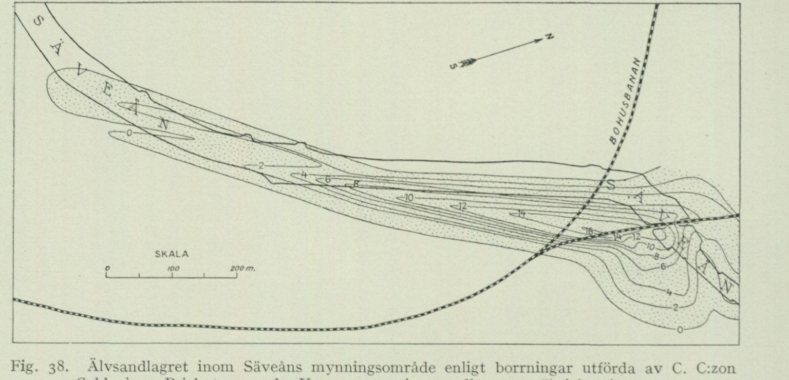
From the occurrence of Carpinus, Fagus, and Picea in the pollen flora throughout the investigated part of the sequence here (i.e. the alluvial clay and the marine clay to about 1 m’s depth below the ground surface) it is evident that this was deposited during the later part of Subatlantic time (zone I of the pollen diagrams, see below). A pollen diagram from the sequence in question is published in »Göteborgstraktens geologi».
The diatom flora in the uppermost part of the marine clay indicates deposition in almost freshened water. The alluvial clay was subsequently deposited when the Kvillebäcken valley, owing to regression and silting-up, came outside the area of seawater influence. Admittedly, the Kvillebäcken valley is still often inundated when high water prevails in the sea, but this water probably does not consist of intruding seawater but of river water from both Göta älv and Nordre älv, which is prevented from draining away by the high water level in the sea.
Alluvial sand (river sand) occurs at two places within the map area. East of Tingstad, a long, narrow sand bar runs parallel to Göta älv, which through a weakly marked ridge form is just barely discernible in the otherwise flat terrain sloping gently towards the river. The sand probably reaches a thickness of about 1 m where the ridge is highest. It was in all probability deposited as a river bank or beach ridge during river inundations in earlier times.
Along Säveån, SW of Gamlestadens fabriker, lies another alluvial sand deposit. It is a delta formation deposited by Säveån during the last regression. As shown in fig. 38, it forms a lenticular body up to 16 m thick, resting on and surrounded by postglacial marine clay. The sand contains plant remains in abundant quantity, such as wood and bark fragments, fruits, seeds, etc. (see the table below), as well as a rich diatom flora, in the lower parts consisting of a mixture of saltwater and freshwater species with a predominance of the saltwater species, which how-
Fig. 38. The river sand deposit within the Säveån estuary area according to borings carried out by C. C:zon Caldenius. Dotted = sand. The curves indicate the thickness of the sand layer in metres.
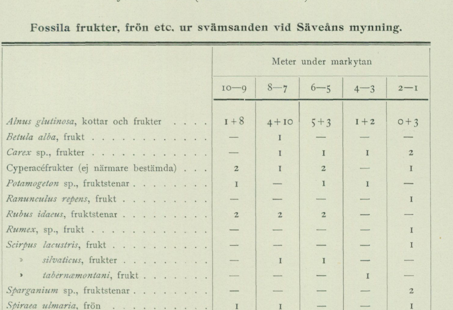
Fossil fruits, seeds, etc., from the alluvial sand at the mouth of the Säveån. Depths are metres below the ground surface (not below sea level). Printed dashes are retained.
| Taxon / remain | 10—9 m | 8—7 m | 6—5 m | 4—3 m | 2—1 m |
|---|---|---|---|---|---|
| Alnus glutinosa, cones and fruits | 1 + 8 | 4 + 10 | 5 + 3 | 1 + 2 | 0 + 3 |
| Betula alba, fruit | — | 1 | — | — | — |
| Carex sp., fruits | — | 1 | 1 | 1 | 2 |
| Cyperaceae fruits (not further determined) | 2 | 1 | 2 | — | 1 |
| Potamogeton sp., fruit stones | 1 | — | 1 | 1 | — |
| Ranunculus repens, fruit | — | — | — | — | 1 |
| Rubus idaeus, fruit stones | 2 | 2 | 2 | — | — |
| Rumex sp., fruit | — | — | — | — | 1 |
| Scirpus lacustris, fruit | — | — | — | — | 1 |
| Scirpus silvaticus, fruits | — | 1 | 1 | — | — |
| Scirpus tabernamontani, fruit | — | — | — | 1 | — |
| Sparganium sp., fruit stones | — | — | — | — | 2 |
| Spiraea ulmaria, seeds | 1 | 1 | — | — | 1 |
| Stachys silvatica, seeds | — | 2 | — | — | — |
| Cenococcum geophilum, fruiting bodies | — | — | 1 | 2 | 4 |
| Cristatella mucedo, winter eggs | — | 1 | 1 | 3 | — |
decrease upwards in frequency, so that the uppermost parts show an almost pure freshwater flora. Fig. 39 is a pollen diagram from a profile through the central part of the sand lens on the southern shore of the Säveån, immediately adjacent to the Bohus railway.1 If one disregards the enormously dominant position occupied by alder, evidently caused by the banks of the Säveån having been covered with dense alder thickets at the time the delta was deposited,2 it emerges from the diagram that the sand layer was deposited during the Sub-boreal and Sub-atlantic periods (zones III, II and I, see below), i.e. the deposition of the delta began during the Bronze Age and continued towards or into historical time.
At certain stages, fine sand cast up by waves at the shores has been accumulated by the wind into “dunes” and fields of wind-blown sand. Apart from some insignificant occurrences here and there at the present shoreline, wind-blown sand has been observed on the Göteborg map sheet at only one locality, namely between the roads NW of the westernmost part of Västra begravningsplatsen, where it occurs as minor fields and dunes of at most 1 metre thickness, partly resting directly
 1 The samples from the sand layer at the Säveån, on which the pollen analysis is based, and from which the fossils listed in the table above have also been washed out, have been kindly placed at the disposal of the Geological Survey of Sweden by Fil. Dr C. C:zon Caldenius.
 2  In the preparations one thus often finds large clumps of alder pollen, anther caps from entire male catkins that have fallen into the water. These clumps are, however, not included in the analysis.
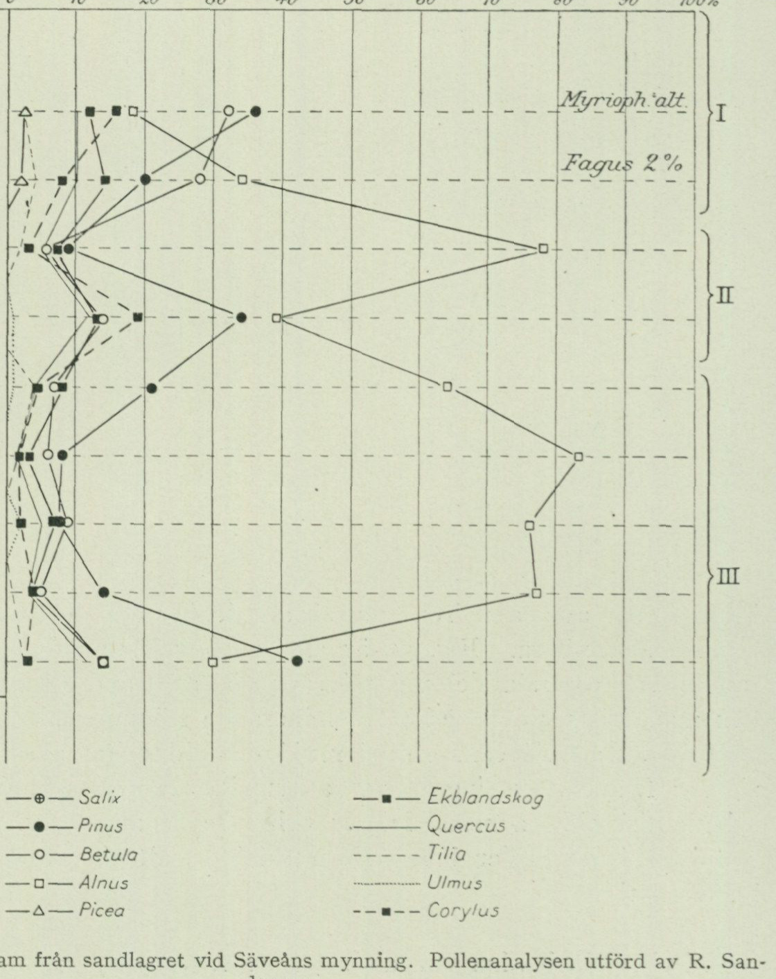
      on the bedrock and partly, as previously discussed on p. 63, on older Quaternary deposits.
      It is possible that the wind-blown sand here was formed at the time of the maximum level of the postglacial sea.
Peatlands. As is apparent from the map, only a relatively insignificant area of the Göteborg sheet is occupied by peatlands. These occur mainly within the
Fig. 39. Pollen diagram from the sand layer at the mouth of the Säveån. The pollen analysis was carried out by R. Sandegren. The complete source-pixel diagram is retained. Percentage scale: 0, 10, 20, 30, 40, 50, 60, 70, 80, 90, 100%. Strata: alluvial sand over postglacial marine clay. Pollen zones I, II, and III are marked. Curves and printed symbols: Salix (circled cross), Pinus (filled circle), Betula (open circle), Alnus (open square), Picea (open triangle), oak mixed forest (filled square), Quercus (solid line), Tilia (dashed line), Ulmus (dotted line), and Corylus (dashed line with filled squares). The upper annotations read “Myrioph. alt.” and “Fagus 2%”.
elevated area E of the valley of the Göta älv and the Mölndalsån, but are few in number on Hisingen and Inland and very rare out in the archipelago. Peat is formed through the accumulation of dead plant remains in places where the soil moisture is so great that the plant remains are protected, to a greater or lesser degree, by the water from free access of air and the consequent decomposition processes. Depending on the air supply and the rate at which new plant litter is supplied to the peatland surface, the peat thus becomes more or less decomposed and attains a higher or lower degree of humification. For-
The degree of decomposition can therefore vary very considerably within a peat layer formed by the same plant species.
Since peat is a product of the plant community living in situ, and this in turn varies according to nutrient availability as well as moisture content, temperature, and other climatic conditions, a peatland will as a rule be built up of a number of different peat types, formed by different plant communities that succeeded one another in place during the growth of the peat and thus show the development the peatland has undergone. Through the study of the succession of plant communities and of the occurrence of fossil plant remains in the stratigraphic sequences, information is obtained about the climatological and phytogeographical development during the postglacial period.
According to the present character of the surface layers and the vegetation, the peatlands of the area have been divided into bogs and fens, which on the map have received the designations Sphagnum peat and fen peat, respectively.
The surface of the bogs is occupied by plant communities which, besides Sphagnum, consist of cottongrass (Eriophorum vaginatum), heather (Calluna vulgaris), cross-leaved heath (Erica tetralix), deergrass (Scirpus caespitosus), and several others, as well as occasionally more or less sparsely distributed, small and stunted so-called bog pines.
The fens, in turn, host plant communities characterized primarily by various sedge species (Carex), brown mosses (Amblystegium), horsetail (Equisetum), and others, but also by certain shrubs and deciduous trees such as alder, birch, and various Salix species.
The greater part of the fen areas of the map sheet are now drained and cultivated, whereby cultivation has displaced the natural vegetation, and the peat, at least at the surface, has become more or less completely transformed into mull. Since, moreover, both fens and bogs have been extensively exploited for peat cutting, there is now hardly any peatland within the map sheet that is unaffected by human intervention and thus retains its original vegetation and character. In quite a few cases, indeed, most of the peat has been dug away, so that the greater part of the former peatland consists of water-filled peat pits. A large former peatland at Gerrebacka in Säve parish has now been converted into a fish pond.
The vast majority of the peatlands in the area appear to have originated through the infilling of former lakes, which is evident from the fact that the bottom layers generally consist of freshwater gyttja. With regard to their mode of formation, they thus belong to the type termed topogenous peatlands. Whether the peatland subsequently developed into a fen or a bog depends on the character of the water supplied to the vegetation living on its surface.
The fen communities require for their thrivall access to nutrient-rich water (rich in dissolved mineral salts), whereas the Sphagnum communities generally shun nutrient-rich water. The Sphagnum mosses therefore colonize such places as are not reached by inflowing nutrient-rich groundwater, e.g. the central parts of a flat fen, where they begin to form hummocks, or a small pool surrounded by fen, where they can form a quagmire. While a fen thus requires a high groundwater level for its growth, caused by inflowing nutrient-rich water, the bog requires water supply only through direct precipitation.
     The *Sphagnum* moss grows by absorbing and storing precipitation, and
     through this the bog surface acquires the dome-shaped convexity that has
     given rise to the term »raised bog».
       The raised bogs, which because of their dependence on precipitation are
     termed ombrogenous peatlands, are usually surrounded by a lower area
     (the lagg), where fen formations flourish, favoured by the nutrient-rich
      water running off from the surrounding dry land. During its continued
      growth, the raised bog transgresses out over the lagg's fen formations,
      which are thus displaced ahead of the bog margin onto the dry land,
      which thereby becomes successively paludified. In the transgression
      area of a raised bog, one therefore almost always finds fen peat between
     the *Sphagnum* peat and the mineral bottom (cf. fig. 40).
Peatland soil types. Before proceeding to an account of the stratigraphy in some peatlands typical of the map sheet area, a brief characterization will be given of the peatland soil types occurring here. These can be classified, with regard to depositional environment etc., into four main groups: limnic or lake deposits, which include freshwater gyttja, bleke, lake dy, and others; telmatic or periodically water-covered deposits, i.e. deposited between the high- and low-water lines of lakes, which include quagmire peat, sedge-Sphagnum peat, sedge peat, fen dy, and others; terrestrial deposits, formed above the high-water line, which include leaf-fen peat, forest-bog peat, and others; and finally ombrogenous deposits, to which the Sphagnum peat of the raised bogs belongs.
Among the freshwater gyttjas, detritus gyttja and calcareous gyttja are noteworthy.
Detritus gyttja is a fine-grained, often somewhat elastic green to green-brown soil type. In air it blackens rapidly, but after drying acquires a more grey colour. It consists of bottom-settled remains of various organisms, such as algae (diatoms and others), fruits, seeds, and finely fragmented remains of higher aquatic plants, remains of lower aquatic animals and their excrement, etc.
Calcareous gyttja contains the same components as detritus gyttja, but in addition a higher or lower content of carbonic-acid lime precipitated with the assistance of various organisms, whereby the colour becomes lighter and varies in yellowish-green and whitish-yellow shades. The soil type effervesces strongly with acid and is often rich in shells of freshwater molluscs and Chara fragments.
Bleke is a dense, cream-white or grey-white granular or weakly elastic soil type whose main mass consists of lime mud, but also contains small amounts of gyttja components as well as clay and sand particles. Mollusc shells and charophyte fragments are common and are sometimes evenly mixed into the mass, sometimes concentrated in thin layers.
Lake dy is a brown to brown-black, when dry black, granular, non-elastic soil type mainly consisting of chemically precipitated humic substances (dy) transported out from the lake surroundings, together with such remains of aquatic plants as are encountered in the gyttjas. Lake dy forms in lakes with water brown-coloured by humic acids, whereas gyttjas form in lakes with clearer and more nutrient-rich water.
Sedge peat is formed in various types of sedge fens. In its most typical, little-decomposed form, it consists mainly of interwoven yellow to yellow-brown rhizomes and fine roots of sedge grass (Carex) and often brown mosses (Amblystegium) with no or insignificant interstitial mass of brown organic mud. At higher degrees of decomposition, the mud substance becomes increasingly dominant and the color therefore darker.
Fen mud is also formed in sedge fens, but in this soil type the mud substance constitutes the main mass, while the sedge grass remains recede strongly and are very finely distributed. Fen mud therefore has a mushy and sticky consistency. The color is usually gray-black.
Wooded fen peat is formed in so-called wooded fens (marshy deciduous forests with undergrowth of fen plants). It consists of various remains of deciduous trees and shrubs such as stumps, branch fragments, twigs, leaves, bark etc. embedded in a groundmass of organic mud and humus material. The color is dark brown, with a reddish tint if alder wood is present in abundance (alder fen peat), grayish, with white bark flakes, if birch wood dominates (birch fen peat).
Sedge-moss peat consists of Carex remains and Sphagnum mosses of various species and in varying proportions. These Sphagnum species are fen forms, which require more nutrient-rich water than the species occurring in the ombrogenic raised bogs. The color is yellow or brown in various shades depending on lower or higher degree of decomposition.
Floating-mat peat is formed in floating mats, which spread out over infilling ponds. It consists of species belonging to the Sphagnum cuspidatum group as well as rhizomes of Scheuchzeria palustris. The color is usually yellowish and the degree of decomposition is low.
Sphagnum peat in the strict sense is formed in the ombrogenic raised bogs mainly of Sphagnum fuscum and related species together with cotton grass, heather, and other dwarf shrubs. The degree of decomposition varies greatly, depending on whether the peat was formed during periods of abundant precipitation (i. e. rapidly), when it becomes yellow to yellow-brown and little decomposed (peat-litter peat), or during periods of more sparse precipitation (i. e. slowly), when it becomes dark brown and strongly decomposed. In addition to some variations in the degree of decomposition and overall character of the Sphagnum peat depending on local conditions, the raised bogs on the Göteborg map sheet, as throughout all of southern and central Sweden, exhibit two stratigraphically clearly distinct divisions, the older and the younger Sphagnum peat. The older Sphagnum peat, formed during the drier climatic conditions of the postglacial warm period, generally shows a high degree of decomposition and dark color, while the younger Sphagnum peat, formed during the precipitation-rich Subatlantic period, is undecomposed and light in color. The sharp boundary between the two divisions, which clearly appears in the walls of peat pits opened in raised bogs, is termed the boundary horizon and dates archaeologically to the transition between the Bronze and Iron Ages.
Forest-moss peat is a Sphagnum peat that is rich in wood remains. It was formed during periods when forest grew on the raised bog, and always shows a
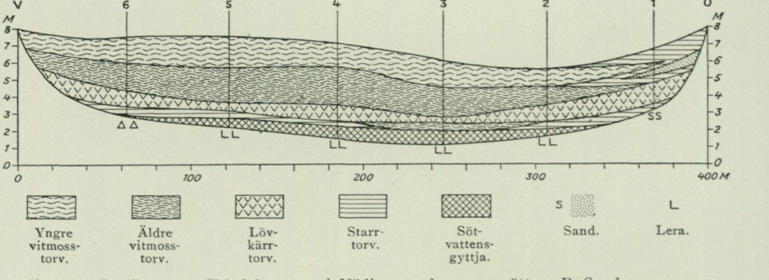
high degree of decomposition. Based on the origin of the wood remains, two variants can be distinguished: birch-moss peat, which is grayish and contains the easily recognizable birch bark, and pine-moss peat, which is dark reddish-brown and contains remains of pine, especially stumps, which are often of considerable dimensions.
Now that we have become acquainted with the most important peatland soil types occurring on the map sheet, a brief description will be given here of some of the peatlands that have been more closely investigated and that are particularly suited to illustrating the development that the Göteborg area has undergone in climatological and phytogeographical respects during postglacial time, and for which a summarizing account will be given in a later chapter.
[Fig. 40. Profile through Skårdals mosse in Nödinge parish, surveyed by R. Sandegren 1924.]
| Younger Sphagnum peat | Older Sphagnum peat | Sedge peat | Freshwater gyttja | Sand | Clay |
|---|
Skårdals mosse. Skårdals mosse lies E of Skårdal in Nödinge parish at ca. 90 m a.s.l. It is a raised bog of approximately 30 ha and is to a large extent taken into use for the production of both peat litter and fuel peat. The natural vegetation, which according to information consisted of heather bog with cotton grass, deergrass, and occasional bog pines, was (1924) mostly destroyed, in that the still undisturbed parts of the bog surface are used as drying fields for the extracted peat.
A profile measured centrally across the southern part of the bog from E to W is reproduced in fig. 40. The substrate of the central part of the bog consists of a loose, gray clay, whose thickness is not known in detail. At profile point 3, where the thickness exceeds 2 m, at least its uppermost part (1.5 m) contains only freshwater organisms (diatoms, Pediastrum species, etc.), wherefore this part must be designated as overflow clay, thus a sediment washed down from the shores into the lake that formed here after the basin’s isolation from the sea. Above the clay follows a layer of detritus gyttja containing i. a. fruit stones of Potamogeton species and seeds of Najas flexilis. The infilling of the small lake proceeded through sedge formations migrating from the shores, which gave rise to sedge peat, and the last open part of the water surface appears to have been closed by a Sphagnum floating mat (profile point 3). Over the thus infilled lake, a wooded fen subsequently spread, which gave rise to the layer of wooded fen peat that with varying thickness extends
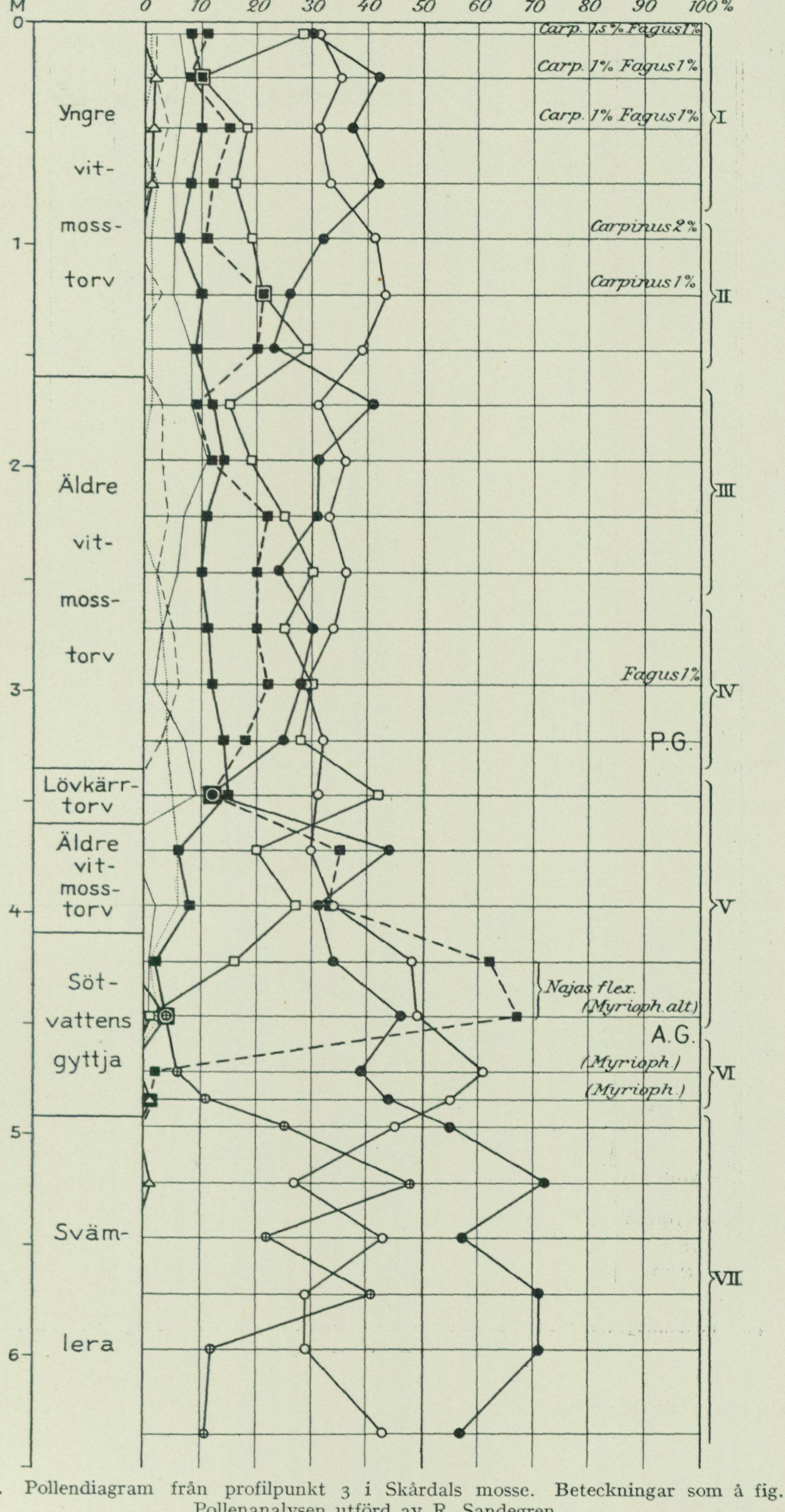
50 0 10 20 30 40 50 60 70 80 90 100
[Fig. 41. Pollen diagram from profile point 3 in Skårdals mosse. Symbols as in fig. 39. Pollen analysis performed by R. Sandegren.]
Stratigraphic labels in diagram: Older Sphagnum peat — Wooded fen peat — Older Sphagnum peat — Overflow clay
Species annotations: Myriophyllum
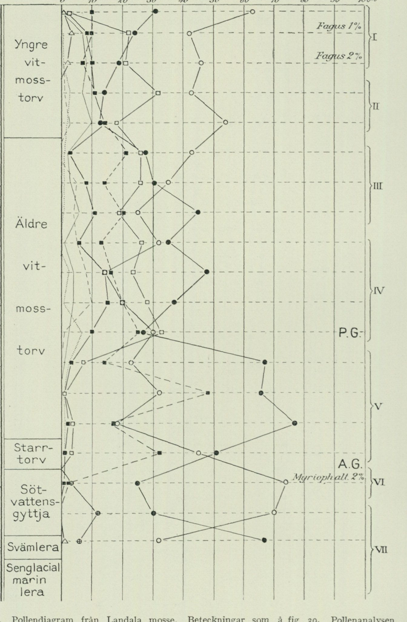
O 10 20 30 40 50 60 70 80 90 100%
Depth
   Sphagnum
   peat

               I

    Older

 2

    Sphagnum
   peat

3

    Sedge
   peat

4
   water-

   Silty
   clay

    Late glacial
   marine
      clay
Fig. 42. Pollen diagram from Landala mosse. Designations as in fig. 39. The pollen analysis was performed by R. Sandegren.
extends across the entire profile section. Above the leaf fen peat follows older Sphagnum peat and uppermost younger Sphagnum peat. Farthest east, this latter is partly equivalent to sedge peat, in the lower part of which a sand layer washed down from firm ground wedges in. Fig. 41 is a pollen diagram from profile point 3. The marked depression around profile point 2 is due at least partly to subsidence of the upper layers as a result of intensive drainage through ditches and peat cutting within this part of the bog.
Landala mosse is situated c. 1 km due E of the Sahlgrenska sjukhuset in Göteborg and at c. 50 m a.s.l. It is most conveniently reached by walking from Kapellplatsen in Landala towards SSE past the allotment gardens located here. It is a moderately domed raised bog with vegetation of Sphagnum, heather, bog myrtle, bell heather and bilberry. Traces of small, nearly overgrown peat pits are visible in several places; otherwise the surface is undisturbed.¹ A boring carried out centrally in the highest part of the bog showed the following stratigraphy (see fig. 42): A. 110 cm Younger Sphagnum peat. B. 250 cm Older Sphagnum peat, c. 2 m below the ground surface with the character of forest bog peat. C. 25 cm Sedge peat. D. 55 cm Detritus gyttja. E. 20 cm Silty clay. F. 140 cm Late glacial marine clay.
Bräcke mosse is the name of a peatland situated c. 500 m NNE of Gunnarslyckan in Torsby parish and at c. 50 m a.s.l. Owing to intensive peat cutting, nothing of the original peatland surface or its natural vegetation appears to be preserved, and at the time of investigation (1920) the greater part of the “bog” was covered by water in which dense stands of Equisetum fluviatile grew. The youngest parts of the original stratigraphy are thus now absent, which is also evident from a boring undertaken in the northern part of the peatland, which showed the following stratigraphy (fig. 43). A. 60 cm Fen gyttja. B. 85 cm Lake gyttja with fruit stones of Potamogeton sp., freshwater diatoms, etc., and in the lowermost part of the layer shells of the freshwater molluscs Limnæa ovata, Pisidium sp. and Valvata cristata. C. 65 cm Calcareous gyttja, downward transitioning into bleke containing freshwater diatoms, desmidiaceans, and shells of Limnæa ovata, Planorbis cfr complanatus and Valvata cristata. D. Clay, grey, loose.
C. 800 m W of Grimbo in Tuve parish and at c. 35 m a.s.l. lies a peatland which, like the one just mentioned, has through peat cutting been largely transformed into a lake covered with water lilies. Within a section projecting into the water on the eastern side of the peat-
1 Such was at least the situation in the autumn of 1922, when the investigation related here took place.
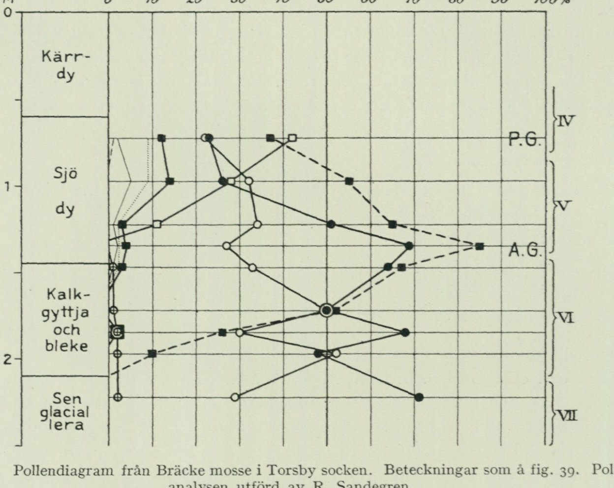
   land, a boring carried out in 1924 showed the following stratigraphy (see fig. 44).
    A.  10 cm Sphagnum peat, constituting a cushion of recent Sphagnum that had colonized a surface stripped of peat through peat cutting. Between this and the following layer there is thus a stratigraphic gap.
    B. 300 cm Leaf fen peat.
     C. 100 cm Detritus gyttja with fruit stones of *Potamogeton* sp., freshwater diatoms, etc.

         M          O     10   20   30   40   50   60    70   80   90   100%

               Fen
               gyttja

                 Calcareous
                   gyttja
                  and
                  bleke

                      glacial
                clay

        Fig. 43. Pollen diagram from Bräcke mosse in Torsby parish. Designations as in fig. 39. The pollen analysis was performed by R. Sandegren.

    D.   15 cm Gyttja with a flora consisting mainly of freshwater diatoms, but additionally with occasional specimens of saltwater diatoms such as: *Bidulfia antediluvianum*, *Diploncis interrupta* and *Paralia sulcata*.
    E.  50 cm Marine clay with abundant salt- and brackish-water diatoms.
     F.   15 cm + Sand.
      The pollen diagram provides valuable information regarding the stage when the shoreline, during the late glacial regression, lay at the 35-metre level in the Göteborg area (see below).
Björkö Björkö mosse is situated in a depression between the mountains centrally on the southernmost mosse. part of Björkö in Öckerö parish. The lowest threshold point of the basin lies at 6.7 m a.s.l. Peat cutting has taken place on a fairly large scale, as evidenced by water-filled, more or less overgrown peat pits. Smaller areas of the apparently original peatland surface remain, however, occupied by a vege-
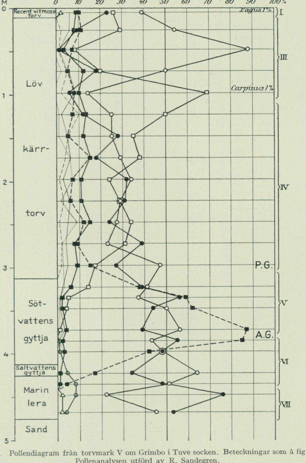
Fig. 44. Pollen diagram from the peatland W of Grimbo in Tuve parish. Symbols as in fig. 39. The pollen analysis was performed by R. Sandegren. The complete source-pixel diagram is retained. Depth scale: 0–5 m; percentage scale: 0, 10, 20, 30, 40, 50, 60, 70, 80, 90, 100%. Strata, top to bottom: recent Sphagnum peat; leaf-marsh peat; freshwater gyttja; saltwater gyttja; marine clay; sand. Pollen zones I, III, IV, V, VI, and VII are marked, together with P.G. and A.G. boundaries. Sample annotations include Fagus 1% and Carpinus 1%. Line symbols are those of Fig. 39.
The vegetation consisted of: Calluna vulgaris, Erica tetralix, Myrica gale, Eriophorum vaginatum, E. angustifolium, Empetrum nigrum, Cornus suecica, Comarum palustre, Menyanthes trifoliata, Carex spp., Sphagnum spp. In the peat cuttings grew at the time of investigation (1923), inter alia, Nymphaea alba, Menyanthes trifoliata, Potamogeton spp., Iris pseudacorus, Comarum palustre, Typha latifolia, Phragmites communis.
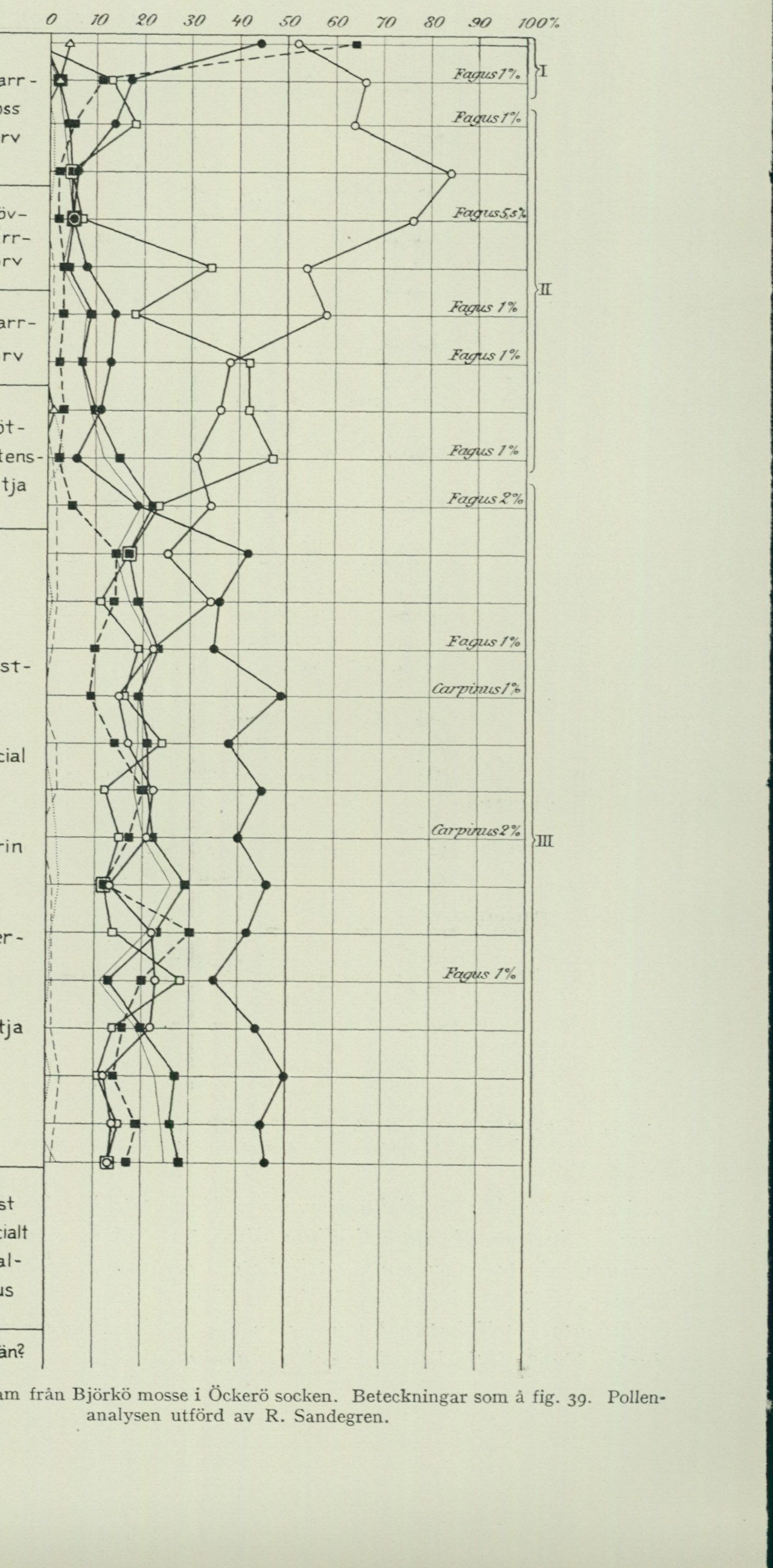
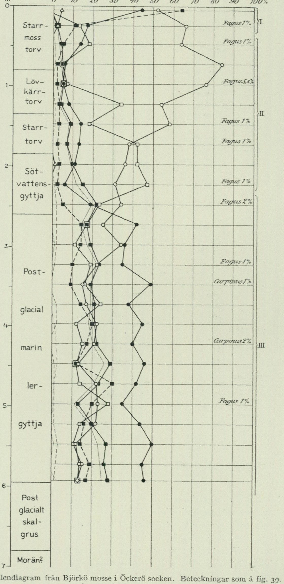
Fig. 45. Pollen diagram from Björkö mosse in Öckerö parish. Symbols as in fig. 39. The pollen analysis was performed by R. Sandegren. The complete source-pixel diagram is retained. Percentage scale: 0, 10, 20, 30, 40, 50, 60, 70, 80, 90, 100%. Strata, top to bottom: sedge-bog peat; leaf-marsh peat; sedge peat; freshwater gyttja; postglacial marine clay gyttja; postglacial shell gravel; till? Pollen zones I, II, and III are marked. Printed sample annotations include Fagus 1%, 2%, and 5.5%, and Carpinus 1% and 2%. Line symbols are those of Fig. 39.
A borehole centrally in the bog showed the following stratigraphy (see fig. 45).
A. 80 cm sedge-bog peat. B. 55 cm leaf-marsh peat. C. 50 cm sedge peat with fruits of Alnus glutinosa and Comarum palustre. D. 75 cm detritus gyttja, dark brownish-green, with fruits of Iris pseudacorus, fruit stones of Potamogeton spp., as well as Pediastrum species and freshwater diatoms, inter alia of the genera Cymbella, Gomphonema and Pinnularia. In the lower part of the layer there also occur scattered saltwater diatoms such as: Actinoptychus undulatus, Diploneis didyma, Navicula lyra, Paralia sulcata, Rhabdonema arcuatum. E. 335 cm clay gyttja, grey-yellowish-green, with a rich flora of saltwater diatoms (cf. above p. 108). In the very uppermost part of the layer there was moreover noted Campylodiscus clypeus, characteristic of brackish-water lagoons, and in its lowermost part fragments of marine mollusc shells. F. 85 cm postglacial shell gravel with a fauna consisting of the species listed in the table, p. 124, second column. G. Till? (stone that prevented further boring).
The stratigraphy within the marginal part of the bog has previously been studied by Gunnar Andersson1 and Rutger Sernander.2 The peat at the point investigated by Sernander has a thickness of 48 cm and rests upon postglacial shell gravel, in which he encountered a number of the species occurring in the shell gravel centrally beneath the bog. Andersson, who carried out his investigation somewhat farther from the edge in the southern part of the bog, found the peat thickness there to exceed 1 m, but did not reach down into the shell gravel. Both Andersson and Sernander describe the peat as clayey and mixed with gyttja (Andersson designates its upper part as flood peat), and it is of course entirely natural that it must have such a character near the margin of the bog, where the water running in from the solid ground collects and deposits such material as it has carried with it. Of interest is the fossil flora encountered in this peat, which according to the aforementioned authors consisted of the following species:
Alnus glutinosa — Potamogeton sp. Betula odorata — Quercus sp. Betula verrucosa — Rhamnus frangula Carex pseudocyperus — Rubus caesius Hippuris vulgaris — Rubus idaeus Juniperus communis — Ruppia cf. maritima Nymphaea alba — Solanum dulcamara Phragmites communis — Sparganium ramosum Polystichum spinulosum — Sparganium sp. Polystichum thelypteris — Taxus baccata Potamogeton (natans?)
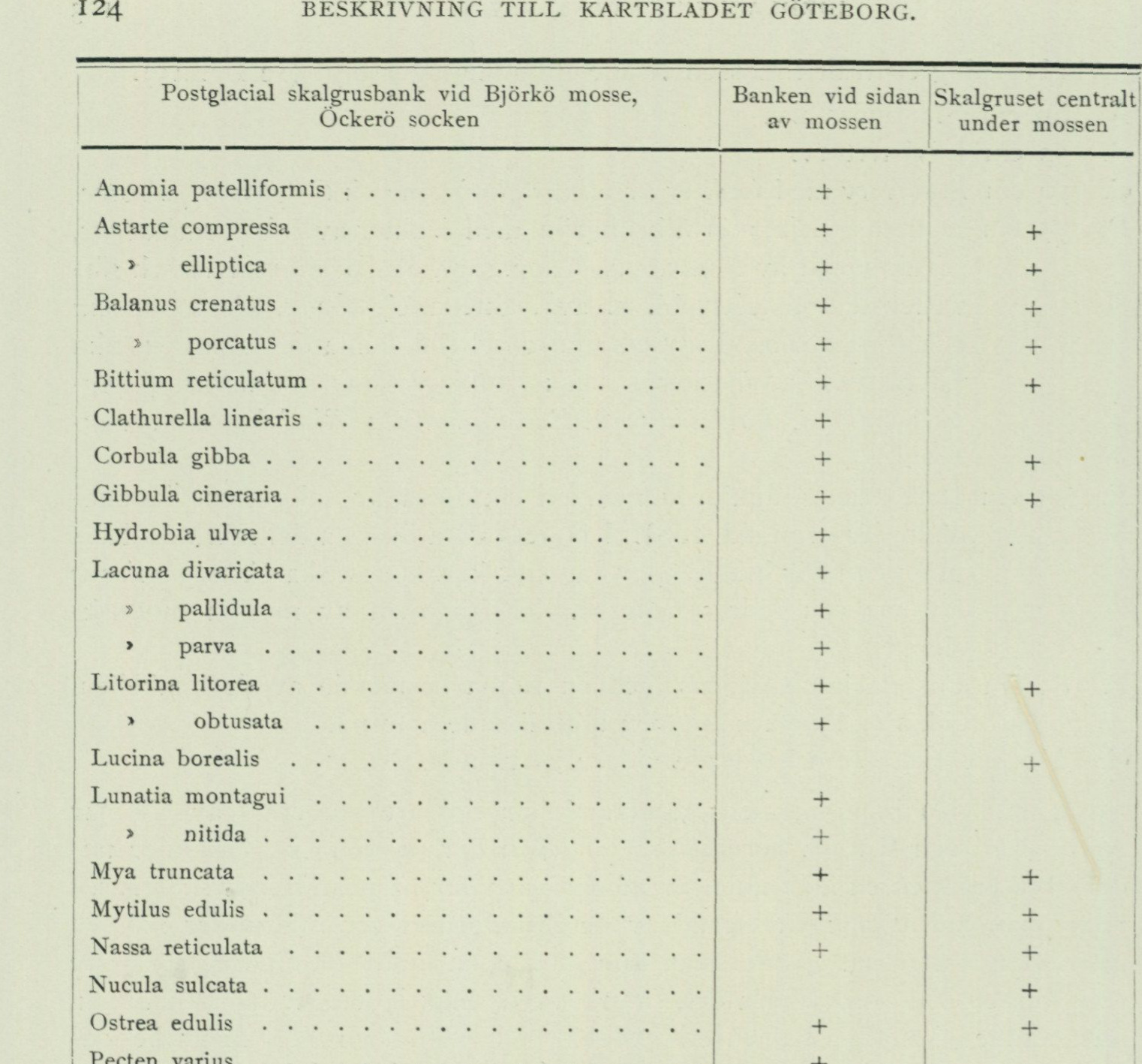
Postglacial shell-gravel bank at Björkö mosse, Öckerö parish. A plus is printed presence; blank cells are blank. The complete source-pixel table is retained.
| Species | Bank at side of marsh | Shell gravel centrally beneath marsh |
|---|---|---|
| Anomia patelliformis | + | |
| Astarte compressa | + | + |
| Astarte elliptica | + | + |
| Balanus crenatus | + | + |
| Balanus porcatus | + | + |
| Bittium reticulatum | + | + |
| Clathurella linearis | + | |
| Corbula gibba | + | + |
| Gibbula cineraria | + | + |
| Hydrobia ulvae | + | |
| Lacuna divaricata | + | |
| Lacuna pallidula | + | |
| Lacuna parva | + | |
| Litorina litorea | + | + |
| Litorina obtusata | + | |
| Lucina borealis | + | |
| Lunatia montagui | + | |
| Lunatia nitida | + | |
| Mya truncata | + | + |
| Mytilus edulis | + | + |
| Nassa reticulata | + | + |
| Nucula sulcata | + | |
| Ostrea edulis | + | + |
| Pecten varius | + | |
| Pilidium fulvum | + | + |
| Purpura lapillus | + | |
| Rissoa membranacea | + | + |
| Saxicava arctica | + | + |
| Tapes aureus | + | + |
| Thracia villosiuscula | + | + |
| Triphora perversa | + | |
| Venus ovata | + | + |
| Verruca stroemia | + | + |
Gunnar Andersson further found a postglacial shell-gravel bank, which lies as an accumulation terrace below the hill at the western side of the marsh.
This bank has later been investigated by R. Hägg, who kindly provided the species list that is found in the first column of the table. The table thus gives an impression of the fauna composition partly in the bank’s proximal part, located c. 7 m above the present sea level, and partly in its distal part, situated c. 6 m lower. As can be seen from the table, most species are found in both parts. The absence of some species in the part situated beneath the marsh
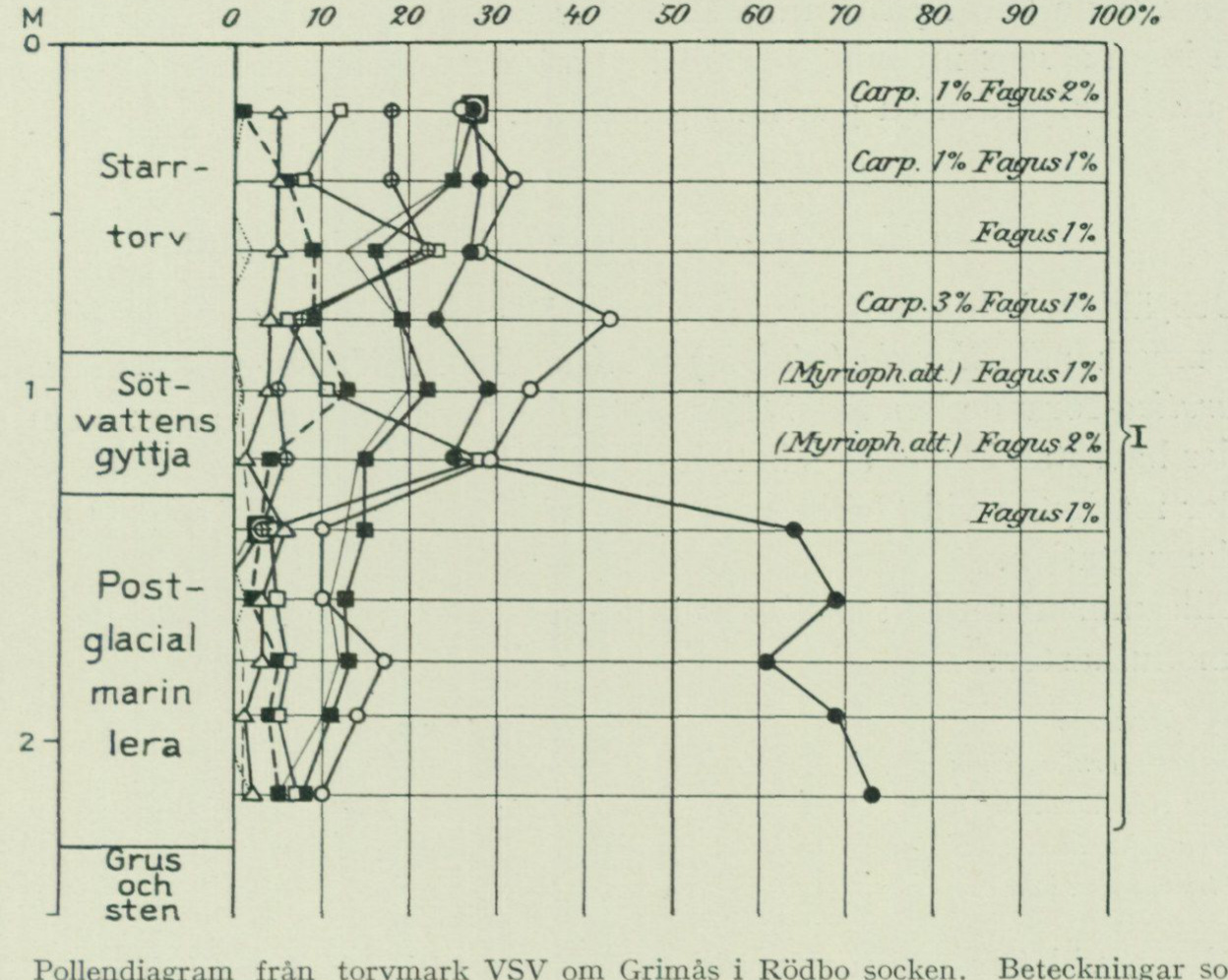
The distal gravel is probably attributable to the fact that only quite small samples of it could be retrieved with a borer. It therefore seems clear that the bank was deposited during a relatively short-lived stage, when the bedrock around Björkö mosses bäcken was brought up into the surf zone by the postglacial regression, whereafter, as appears from the pollen diagram fig. 45, marine clay gyttja was deposited on top of the shell gravel during Subboreal time, when the surrounding heights provided protection against stronger movements in the water, which during the continued regression became ever shallower within Björkö mosses bäcken — a deposition that continued up to the time when the connection with the sea via the lowest pass points was severed and the water there became fresh.
Fig. 46. Pollen diagram from peatland WSW of Grimås in Rödbo parish. Symbols as in fig. 39. The pollen analysis was carried out by R. Sandegren.
The complete source-pixel diagram is retained. Diagram scale: depth 0–2+ m; pollen percentages 0, 10, 20, 30, 40, 50, 60, 70, 80, 90, 100%. Sediment sequence, top to bottom: sedge peat; freshwater gyttja; postglacial marine clay; gravel and stones. Sample annotations from top downward are: Carp. 1%, Fagus 2%; Carp. 1%, Fagus 1%; Fagus 1%; Carp. 3%, Fagus 1%; (Myrioph. alt.), Fagus 1%; (Myrioph. alt.), Fagus 2%; Fagus 1%. Pollen zone I spans the sampled sequence. Line symbols are those defined in Fig. 39. The abbreviated Myrioph. alt. is preserved exactly as printed rather than conjecturally expanded.
Southeast of, adjacent to the main road WSW of Grimås in Rödbo parish, and then further westward up to Nordre älv, extends a small valley depression, which formerly constituted an arm of the river. It is now occupied by three small tarns and cultivated peatlands. The peatland surface east of the easternmost tarn lies ca. 2 m a.s.l. A boring undertaken here (1925) showed the following stratigraphy (see fig. 46).
A. 90 cm sedge peat. B. 40 cm detritus gyttja with fruit stones of Potamogeton sp. and a rich flora of common freshwater diatoms. C. 200 cm postglacial marine clay with a diatom flora consisting partly of salt- and brackish-water species showing an upward-decreasing salinity
in the water in which the clay was deposited, partly of freshwater species, among which some so-called arenaria forms characteristic of the deposits of Vänern are especially prominent. In the lowermost part of the layer shell fragments were also found, inter alia of Gibbula cineraria. D. Gravel with large stones, which prevented further boring.
From the pollen diagram it appears that the entire stratigraphy belongs to the later part of the Subatlantic period (see below). The occurrence of arenaria forms in the marine clay is due to the mixing of seawater and river water that takes place within the river’s estuary area. In our days the water in the inner part of Älvefjorden has a rather low salinity.
The immigration sequence of the lower marine fauna.
The oldest fauna appearing in the marine clays is characterized by the Arctic mussel Portlandia (Yoldia) arctica. Within the Göteborg city area, P. arctica-bearing clay has been found at three localities, namely 1) at ca. 6 m depth below sea level in the bottom of Göta älv off Masthugget, 2) at 3—3.5 m depth below the ground surface at Gullbergsvass, 3) at the railway viaduct NE of Olskroken station. Together with P. arctica, the following mollusc species have been encountered at these localities in total:
Axinus flexuosus Nucula tenuis Buccinum groenlandicum Trophon clathratus Lunatia groenlandica Yoldia hyperborea Macoma calcaria » limatula Mya truncata v. uddevallensis
In the clay at Olskroken the following foraminifera also appear:
Cassidulina crassa (D’Orb.) Miliolina seminulum (L.) laevigata (D’Orb.) Polystomella striatopunctata (Park. o. Jones).
This fauna is Arctic and at its immigration followed almost immediately the retreating ice margin. An interesting detail concerning the conditions during the fauna’s immigration has emerged from an investigation carried out in 1924 by Dr N. Hj. Odhner in the clay pit of Steken’s brickyard immediately NE of Agnesberg station. The locality is situated in the valley, surrounded by high and steep mountains, that extends from Götaälvsdalen in an easterly direction up to Rösered. South of, adjacent to the main road approximately halfway between the river and Rösered, the clay pit offered an excellent profile through the Quaternary valley fill. This consists at the top of 10.6 m clay, which is underlain by sand to unknown thickness. The contact between the sand and the clay lies here at 19.3 m a.s.l. The clay is varved in its lower part, and 105 annual varves have been measured here. The 9 lowermost varves lack fossils, but in varve 10 Modiolaria laevigata appears, in varve 11 Mytilus edulis, in varve 15 Balanus crenatus and Macoma calcaria. B. crenatus and M. edulis have also been found in varves 17 and 23, respectively. Varves 30—46 contain Portlandia arctica and P. lenticula.
Portlandia arctica and P. lenticula. Varves 55—105 contain (with the exception of x ex. Portlandia arctica in varve 66 and P. lenticula in varve 90) the following species:
Balanus crenatus Modiolaria laevigata Buccinum groenlandicum Mytilus edulis Macoma calcarea Saxicava arctica
This fauna, in which Mytilus dominates, appears to prevail also within a 0.5 m thick zone, probably comprising about 20 years, immediately above the uppermost distinctly identifiable annual varve. Next follows a 1 m thick zone, probably comprising at least 50 years, containing abundant large specimens of Portlandia arctica and only very sparse fragments of Mytilus, as well as Balanids, Leda pernula, Nucula tenuis and Portlandia lenticula. Above this comes finally a 0.9 m thick zone of unbedded clay with Balanus crenatus, Macoma calcarea, Mya truncata, Mytilus edulis, Nucula tenuis and Saxicava arctica. During the time the clay was deposited here, repeated changes have thus occurred in the fauna living on the site, which is probably due to variations in the nature of the water, caused by current conditions in the sea outside the melting ice margin. A fauna characterized by Mytilus edulis has alternated with another, characterized by Portlandia arctica, and the characteristic species of the two faunas appear to almost completely exclude each other. Counting from the year when the clay began to be deposited here, the Mytilus fauna thus prevailed during years 10—23, the Portlandia fauna during years 30—46, the Mytilus fauna during years 55—c. 125, after which the Portlandia fauna again prevailed for at least 50 years, to finally be succeeded by the Mytilus fauna. Portlandia arctica thrives in cold meltwater. Mytilus edulis in warmer and saltier seawater. From this it can be concluded that, during the stages with the Portlandia fauna, large amounts of cold meltwater flowed out from the ice margin, while during the stages with the Mytilus fauna, inflowing warmer and saltier seawater dominated at the site where the clay pit of Stekens tegelbruk is now located. It is tempting to try to relate these conditions to such oscillations of the ice margin, to which it, as mentioned above, was subjected on repeated occasions during the melting period. The first 2—3 decades undoubtedly appear to represent a period of rapid melting and recession of the ice margin, during which the oldest Mytilus fauna immigrated, favoured by an inflow of seawater, arising as a reaction current to the outflowing meltwater, which brought the larvae. The following two decades, during which the Mytilus fauna was replaced by the Portlandia fauna, could be imagined to correspond to the advance of the ice margin that led to the formation of the Röseredsplatå, located just under half a km to the E. A decreased amount of outflowing meltwater probably led to a weakening of the inward-flowing saline reaction current, which, along with the proximity of the ice margin, favoured the appearance of the Portlandia fauna. Then follows during the nearest
about 75 years a renewed rapid deglaciation and reimmigration of the Mytilus fauna. The second appearance of the Portlandia fauna at the locality could then be linked to a renewed advance of the ice margin, perhaps recorded by the ice-marginal line located about 15 km to the east, which Munthe in “Göteborgstraktens geologi” named the Hjärtum—Hyssna line. The final return of the Mytilus fauna would then represent the stage when the second advance of the ice margin had been replaced by recession.
The fauna that had managed to immigrate into the area already during the stage when deposition of the varved clay was ongoing and the proximity of the ice margin thus still imparted an Arctic character to the sea here,¹ consequently consists of the following species:
Axinus flexuosus (Mont.) Mytilus edulis (L.) Balanus crenatus (Brug.) Nucula tenuis (Mont.) Buccinum gröenlandicum (Chemn.) Portlandia arctica (Gray) Leda pernula (Müll.) » lenticula (Möll.) Lunatia groenlandica (Beck) Saxicava arctica (L.) Macoma calcaria (Chemn.) Trophon clathratus (L.) Modiolaria laevigata (Gray) Yoldia hyperborea (Lovén) Mya truncata (L.) » limatula (Say) (Sars)
For gaining knowledge of the continued immigration of the marine fauna during late- and postglacial time, there are no such stratigraphic sequences available as the outstanding section at Steken; instead, the dating of the scattered fossil-bearing deposits must be sought by relating the localities to the course of the shoreline displacement, which has been briefly described above and which will be treated in greater detail in the following chapter. During the ongoing land uplift, fossil-bearing layers were deposited, as already emphasized, at various depths, and moreover the material has to a large extent been subject to successive reworking. The highest level at which a certain species is found will thus indicate only a minimum value for the land-uplift stage at which the species in question immigrated, partly because the deposition of the material in itself requires a certain water depth, and partly because in most cases it is difficult to determine whether the shells are in their primary position or not. As regards the more rare species in particular, the risk is thus great that one has not succeeded in finding them already at the level corresponding to the time of their first appearance in the area. It is therefore important to have access to as large a body of observational material as possible, and for this reason the following account takes into consideration not only the material collected from the map sheet Göteborg itself, but also material from the areas immediately adjacent to it, par-
¹ The marine molluscs are classified with regard to their distribution into Arctic, boreal, and Lusitanian; the Arctic species have their principal modern distribution within the Arctic seas down to Iceland and Nordkap, the boreal species from SW Iceland, the Faroe Islands, and Nordkap, down to the eastern part of the English Channel, the Lusitanian south of Scotland—Faroe Ridge and the eastern part of the English Channel. A large number of both Arctic and boreal species thrive excellently, however, also within more southerly areas. If, guided by the occurrence of fossil molluscs, one wishes to obtain information about the climatic changes of the Quaternary, it is therefore most important to have knowledge of the northern limit of the distribution of the various species. It is thus principally the absence of boreal and Lusitanian species within our older late-glacial deposits that, together with the presence of certain specifically high-Arctic species, indicates the Arctic character of the prevailing climate, while on the other hand the fossil occurrence of Lusitanian species north of their present northern limits definitely indicates a formerly warmer climate.
especially in the north, where investigations have been extended as far up as to Tjörn and the southernmost part of Ödsmåls parish.1 The highest situated shell gravel bank in the area is found at Ribbetegen in Ödsmåls parish 107.6 m a. s. l. at 87 % of the highest marine limit (M. G.). The fauna here consists of the following species:
Balanus crenatus Mya truncata » porcatus (Da Costa) Mytilus edulis Macoma calcaria Saxicava arctica
The same fauna is also found in the highest shell-bearing deposit within the Göteborg map sheet, namely the clay E of Kallebäck, situated 80 m a. s. l. at 82 % of M. G. At 77 % of M. G. Litorina rudis (Maton) appears for the first time, found in clay SSE of Assared in Angereds parish. In shell gravel banks at 75—70 % of M. G. the following are added:
Litorina littorea (L.) and Macoma baltica (L.) Both of these species are shallow-water forms, and the said level may therefore be considered to provide reliable information about their time of immigration. Macoma baltica occurs, according to Hägg12, abundantly in western Sweden’s highest situated shell gravel bank in Silbodals parish 167.3 m a. s. l. c. 90 % of M. G. in western Värmland, and thus belongs to the oldest fauna appearing there. That the species is absent in the highest situated banks in the Göteborg area is due to these being older than the Värmland bank, since the Göteborg area was freed from ice much earlier than southwestern Värmland. M. G. in Värmland was thus formed at a more advanced stage of land uplift than M. G. in the Göteborg area. M. G. namely represents no synchronous shoreline but a series of successive shore levels, which become increasingly younger reckoned from the peripheral parts of the glaciated area toward its centre. One can therefore not use percentage values of M. G. for chronological correlation over greater distances, but only within fairly limited areas. For the area treated here, however, the method may be used without risk of any more significant errors. At the levels 70—65 % of M. G. the following species are added:
Astarte borealis (Chemn.) in shell gravel Margarita groenlandica (Chemn.) in clay Balanus balanoides (L.) » » » helicina (Phipps) » » Buccinum undatum (L.) in clay Modiolaria discors (L.) » » Lacuna divaricata (Fabr.) in clay and shell gravel Neptunea despecta (L.) » » Lyonsia arenosa (Möll.) in clay Trophon truncatus (Ström) » »
1 The greater part of this material from the shell-bearing marine
deposits of the Göteborg area and southern Bohuslän was collected during the field work of the Geological Survey of Sweden by O. Claesson, H. Munthe, N. Odhner, A. Hj. Olsson and R. Sandegren. In addition, the Survey has acquired material collected by E. Ljungner on Tjörn; furthermore R. Hägg kindly placed at the disposal species lists from a number of localities, and finally consideration has been given to I. D. Wallerius’ valuable investigations of the interesting postglacial shell gravel bank at Linneviken on Tjörn (G. F. F. Vol. 46, 1924 and Vol. 49, 1927). A more detailed account of the late-Quaternary history of the Göteborg area and southern Bohuslän is intended to appear in the publication series C of the Geological Survey of Sweden. 2 Hägg, Richard, Västra Sveriges nordligaste och högst belägna skalbank. G. F. F. Vol. 45, 1923, p. 436—440.
Of these, Astarte borealis, Buccinum undatum, Margarita groenlandica, M. helicina, Neptunea despecta and Trophon truncatus are deep-water forms, and their immigration therefore probably took place somewhat earlier than the level indicates. Lacuna, on the other hand, is a shallow-water form. At this level there appears, for the first time alongside the arctic species, a boreal species, Modiolaria discors, which has its northern limit at Vadsö, and thus indicates an improvement in the climate. In shell gravel banks at 65—60 % of M. G. the following species are added: Astarte compressa (Mont.) Verruca stroemia (Müll.) Cingula castanea (Möll.) Zirphaea crispata (L.) Pecten islandicus (Müll.)
Of these, the three first-mentioned are deep-water forms, while Zirphaea is a shallow-water form. In shell gravel banks at 60—55 % of M. G. the following are added: Anomia squamula (L.), Bela violacea (Migh.), Puncturella noachina (L.), the last-mentioned a deep-water form.
At the levels 55—50 % of M. G. the following species are added: Acmaea rubella (Fabr.) in shell gravel Boreochiton marmoreus (Fabr.) in clay Astarte elliptica (Brown) » » Litorina palliata (Say) » shell gravel Balanus hameri (Asc.) » » Margarita cinerea (Couth.) » clay
Of these, Astarte elliptica, Balanus hameri and Margarita cinerea are deep-water forms, Litorina a shallow-water form. In shell gravel banks at 50—45 % of M. G. the following are added: Cyprina islandica (L.) Modiola modiolus (L.) Lepeta coeca (Müll.) Sipho latericeus (Möll.)
of which the two first-mentioned are deep-water forms. At the levels 45—40 % of M. G. the following species are added: Acmaea virginea (Müll.) in shell gravel Moelleria costulata (Möll.) in shell gravel Anomia striata (Lovén) » » Natica clausa (Brod.) in clay and shell gravel Bela decussata (Couth.) » clay Odostomia unidentata (Mont.) in shell gravel » pyramidalis (Ström) in clay and shell gravel Onoba aculeus (Gould) » »
Anomia striata, Bela decussata, Moelleria and Natica are deep-water forms, Onoba aculeus a shallow-water form. The appearance of the boreal species Anomia striata, which has its northern limit at Lofoten, gives an indication of the continued climatic improvement. At the levels 40—35 % of M. G. no new species are added, but at 35—30 % of M. G. the following appear: Amauropsis islandica (Gmel.) in clay Astarte sulcata (Da Costa) in shell gravel Leda minuta (Müll.) » » Velutina laevigata (Penn.) » » The three first-mentioned are deep-water forms. At the levels 30—25 % of M. G. the following species are added: Bela rugulata (Troschel) in clay Litorina obtusata (L.) in shell gravel Boreochiton ruber (Lowe) in shell gravel Lunatia montagui (Forb.) » » Homalogyra atomus (Phil.) » » Onoba proxima (Alder) » » Hydrobia ulvae (Penn.) » » Skenea planorbis (Möll.) » »
Of these, Bela rugulata, Boreochiton ruber and Lunatia montagui are deep-water forms. Shallow-water forms are Homalogyra, Hydrobia and Skenea. Boreal species are Homalogyra and Lunatia montagui. The deposits at the latter-mentioned level are the lowest that are situated above the postglacial transgression limit. As we know, the regres- sion continued at least as far down as to a level that at Göteborg now lies ab. 16 m a. s. l., i. e. to at least ab. 17 % of M. G., after which the transgres- sion occurred that moved the shore up to P. G. Shell gravel deposits deposited during the first regression from the P. G. level and downwards have therefore been exposed to a greater or lesser extent to reworking and redeposition during the transgression, which is why the shell gravel banks below P. G. contain a mixture of the fauna that immigrated during the first (late-glacial) regression, during the postglacial transgression, and during the last (postglacial) regression. The sequence of immigration of species after the time when the shore, during the late-glacial regression, passed the P. G. level in the Göteborg area, must therefore be determined within an area that has not been reached by the postglacial transgression. An account of the occurrence of these later immigrants in the postglacial deposits of the Göteborg area, expressed in % of P. G., will however be given here, but the increased uncertainty in the determination of the minimum age of the species in the area, which is due to the fact that one can by no means venture to expect that all the species that immigrated during the first regression from the P. G. level and during the transgression, will have happened to be found in the highest postglacial shell gravel bank, must be expressly emphasized here. As mentioned above, the highest situated postglacial shell gravel bank in the area lies on Rörö in Öckerö sn and constitutes a distal shore accumulation in direct connection to the postglacial limit moraine. The bank lies 21.7 m a. s. l. at 88 % of P. G. and contains the following newly added species:
*Alvania punctura (Mont.) *Pecten varius (L.) *Anotnia pcUelliformis (L.) Pilidium fulvum (Mull.) *Bittium reticulatum (Da Costa) Purpura lapillus (L.) *Cardium edule (L.) *Retusa truncatula (Brug.) » fasciatum (Mont.) Rissoa interrupta (Ad.) *Clathurella linearis (Mont.) * » membranacea (Ad.) *Gibbula cineraria (L.) * » parva (Da Costa) » tumida (Mont.) * » violacea (Desm.) Lacuna pallidula (Da Costa) * Tapes aureus (Gmel.) *Nassa reticulata (L.) * » pullastra (Mont.) Onoba striata (Mont.) *Triphora perversa (L.)
-
O strea edulis (L.) * Venus ovata (Penn.)
The species marked with a star are boreal, and several of them occur only within the southern parts of the boreal region, which is why their occurrence here indicates that a highly significant climatic amelioration took place during the latter part of the late-glacial regression and during the post- glacial transgression.
In shell gravel banks at levels 70—60 % of P. G. the following species are added:
Atys utriculus (Brocchi) Patella vulgata (L.) Cardium nodosum (Turt.) Pholas candida (L.) Corbula gibba (Olivi) Sipho togatus (Mörch) Ludna borealis (L.) Solen ensis (L.) Montacuta bidentata (Mont.) Syndosmya alba (Wood) Nassa incrassata (Ström) » longicallis (Scacchi) Nucula nitida (Sow.) Thracia papyracea (Poli) Odostornia rissoides (Hanl.) Venus gallina (L.)
All except Sipho togatus are boreal species. Sipho togatus is high-arctic but a pronounced deep-water form, which is why its immigration must be assumed to have taken place during an early stage. The specimens found in shell gravel at this level are therefore certainly in a secondary locality. At levels 60—50 % of P. G. are added:
Aporrhais pes pelecani (L.) Nucula sulcata (Bronn) Mactra subtruncata (Da Costa) Trichotropis borealis (Brod. & Sow.)
The first three mentioned species are boreal. Trichotropis is an arctic- boreal deep-water species, which is why what has been said above regarding Sipho togatus is probably applicable also to this, moreover, rather rare species. In shell gravel banks at levels 50—40 % of P. G. the following species are added:
Bela schmidtii (Friele) Nucula nucleus (L.) Cardium echinatum (L.) Parthenia spiralis (Mont.) Crenella decussata (Mont.) Rissoa inconspicua (Aid.) Kellya suborbicularis (Mont.) Tapes decussatus (L.) Lucinopsis undata (Penn.) Tellimya ferruginosa (Mont.) Lunatia nitida (Forb. & Hanl.) Thracia convexa (Wood) Mactra elliptica (Brown) Turritella communis (Lam.) Nacella pellucida (L.)
Of these, Tapes decussatus is a Lusitanian species that no longer lives in Bohuslän. It is the characteristic species of the group of Lusitanian species that found agreeable conditions there during the postglacial warm period, and after it the postglacial sea has also been named the Tapes Sea. In shell gravel banks at levels 40—30 % of P. G. are added:
Calliostoma miliare (Brocchi) Lepton nitidum (Turt.) Cardium minimum (Phil.)
All three are boreal species. Lepton nitidum, however, no longer extends further north than to Bergen and the Oslofjord. In shell gravel banks at levels 30—20 % of P. G. the following species are added:
Acteon tornatilis (L.) Cardium norvegicum (Spengler) Alvania cimicoides (Forb.) Cerithiopsis tubercularis (Mont.) Änomia aculeata (L.) Cingula soluta (Phil.) Arcinella plicata (Mont.) Cochlodesma prcetenue (Pult.) Axinus sarsii (Phil.) Coecum glabrum (Mont.) Callochiton leevis (Mont.) Cyamium minutum (Fabr.) Cardium exiguum (Gmel.) Cylichna cylindracea (Penn.)
Diaphana hyalina (Turt.) Onoba vitrea (Mont.) Dosinia exoleta (L.) Parthenia indistincta (Mont.) » lineta (Pult.) » interstineta (Mont.) Emarginula fissura (L.) Pecten striatus (Müll.) Eulimella acicula (Phil.) Portlandia tenuis (Phil.) » scillae (Scacchi) Psammobia depressa (Penn.) Lacuna parva (Da Costa) » ferröensis (Chemn.) Lasaea rubra (Mont.) Retusa mammillata (Phil.) Lepidopleurus asellus (L.) Scalaria clathrus (L.) » cancellatus (Sow.) Scrobicularia piperata (Gmel.) Mangelia nebula (Mont.) Sipho islandicus (Chemn.) Modiola phaseolina (Phil.) Syndosmya nitida (Müll.) Odostomia acuta (Jeffr.) Tapes virgineus (L.) » ambigua (Maton & Racket) Thracia villosiuscula (Macg.) Most of these species are boreal. Psammobia depressa is a Lusitanian shallow-water species. In shell-gravel banks at the levels 20—10 m above P. G. the following are added:
Odostomia conoidea (Brocchi) Philine scabra (Müll.) Pecten opercularis (L.)
All three are boreal deep-water species. At the levels 10—0 m above P. G. the following species are finally added:
Capulus hungaricus (L.) Nassa pygmaea (Lam.) Cultellus pellicidus (Penn.) Philine aperta (L.) Isocardia cor (L.) Solecurtus antiquatus (Pult.) all found in clays except Nassa pygmaea, which has also been encountered in shell gravel. The five first-mentioned are boreal, Solecurtus Lusitanian. All are deep-water species, which is why they, like the species reported from the immediately preceding level, probably immigrated during a relatively early postglacial stage. The absence of Lusitanian species in the fauna now living in the Göteborg area indicates that the climate has deteriorated again after the warm period. As the youngest immigrant, Mya arenaria (L.) may finally be mentioned; it now lives here but has never been encountered in deposits at a higher level than the present shoreline.
Development of climate and vegetation in relation to the changes of level.
Supported by the fossil animal and plant remains encountered in the Late Quaternary stratigraphic sequences and by the testimony of these sequences regarding the changes of level that have taken place, a brief account shall here be given of the development of climate and vegetation in the Göteborg area during Late Quaternary time (cf. the table below, which aims to provide an overview of the subdivisions of the Late Quaternary made from various viewpoints, and of the relationships of the various divisions to each other, to the archaeological periods, and to the historical chronology¹). The presentation adheres most closely to the
¹ It should be pointed out here that the dating of the older stages is rather uncertain. This applies
in particular to the Late Glacial regression stage, the duration of which cannot yet be considered definitively established.
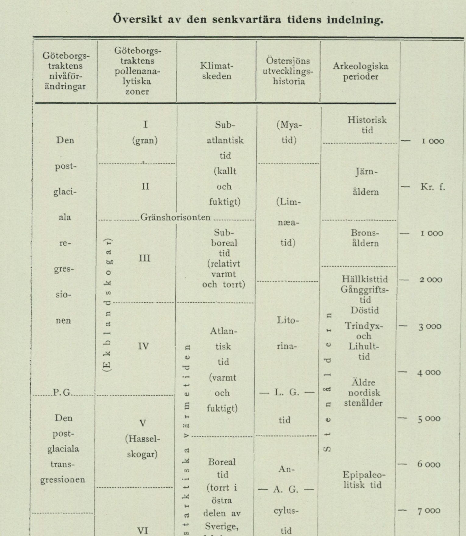
Overview of the subdivision of Late Quaternary time
The complete multi-column chronology is reproduced in the source table image below. Its columns are:
- Shore-level changes in the Göteborg district
- Pollen-analytical zones in the Göteborg district
- Climatic phases
- Development history of the Baltic Sea
- Archaeological periods
- Year scale
Pollen-analytical zones: I (spruce); II; boundary horizon; III; IV (oak mixed forest); V (hazel forests); VI (pine and birch forests); VII (pine and willow).
Climatic phases: Subatlantic time (cold and humid); Subboreal time (relatively warm and dry); Atlantic time (warm and humid); Boreal time (dry in eastern Sweden, more humid along the west coast); Subarctic time; Arctic time.
Baltic Sea development: Mya time; Limnaea time; Littorina time (L. G.); Ancylus time (A. G.); Yoldia time; Baltic Ice Lake; Dryas flora.
Archaeological periods: Historical time; Iron Age; Bronze Age; Stone-cist period (Hällkisttid); Passage-grave period (Gånggriftstid); Dolmen period (Döstid); Trindyx and Lihult period (Trindyx- och Lihulttid); Older Nordic Stone Age; Epipalaeolithic time.
Year scale: AD 1000; Birth of Christ; 1000 BC; 2000 BC; 3000 BC; 4000 BC; 5000 BC; 6000 BC; 7000 BC; 8000 BC; 9000 BC; 10,000 BC; 11,000 BC.
zoning that has been made in the pollen diagrams published here (fig. 35, 39 and 41—46). To the areas that already emerged above sea level at the time of the ice retreat, an arctic flora first migrated, characterized by mountain avens (Dryas octopetala), dwarf birch (Betula nana) and several willows (Salix). The climate was then a tundra climate, comparable to that which now prevails in northern Siberia. The nearest locality to Göteborg where fossil remains of such arctic flora have been found is in freshwater clay beneath Håle mosse, located SW of Kållereds kyrka somewhat more than 1 mil S of Göteborg.1 Soon, however, birch and pine arrived. The oldest zone of the pollen diagrams (VII) is thus characterized by pine, birch and Salix, besides which spruce occurs sporadically (Skårdals mosse, Landala mosse, the peatland W of Grimbo). During this stage the shoreline displacement appears to have progressed so far that the present 50-metre level in the Göteborg area emerged above sea level (Landala mosse), whereas this was not yet the case with the 35-metre level (the peatland at Grimbo). See fig. 36, 42 and 44. Zone VI of the pollen diagrams probably belongs to the earlier part of the Boreal period (Yoldia time and the earlier part of Ancylus time). During this stage, as a consequence of the post-arctic climatic improvement, hazel, elm and oak migrated in, besides which pollen of Myriophyllum alterniflorum is often encountered in the gyttja belonging to this zone. The late-glacial regression had been completed, so that at least the present 16-metre level at Göteborg was brought onto dry land (Änggården), and the postglacial transgression that followed the regression had begun. The upper boundary of the zone (marked in the pollen diagrams by the beginning of the alder curve) falls, according to von Post12 3at the time of the dwindling of the Svea älv and the transgression maximum of the Ancylus Lake in the southern Baltic area. Zone V of the pollen diagrams represents the time from the aforementioned point up to the maximum of the postglacial transgression, and thus encompasses the end of the Boreal and the earlier part of the Atlantic period. At the beginning of the stage, as mentioned, alder pollen appears for the first time in the diagrams and shows a frequency rapidly rising upwards. The mixed-oak forest curve likewise rises. The most characteristic feature of the stage, however, is the here falling absolute maximum of the hazel curve. The high hazel frequency indicates, according to von Post8, the presence of pure hazel forests, a vegetation type favoured by a mild climate with relatively abundant precipitation, at least in winter. During this stage the aquatic plant Najas flexilis, now almost entirely disappeared from our country, lived at Skårdal (cf. above pp. 116—117 and4 *). Furthermore, the great fen-sedge (Cladium mariscus) appears to have been present in the Göteborg area at this time. It has indeed not yet been found fossil within the
 1 Andersson, Gunnar, Om de växtgeografiska och paleontologiska stöden för antagande af klimatväxlingar under kvartärtiden, G. F. F. Bd 14, 1892.  Andersson, Gunnar, Växtpaleontologiska undersökningar af svenska torfmossar, 2, Bih. t. K. Sv. Vet.-Akad. Handl. Bd 18, Afd. III N:o 8, 1893.  Sernander, Rutger, Bidrag till den västskandinaviska vegetationens historia i relation till nivåförändringarna, G.F.F. Bd 20, 1902.
2 von Post, Lennart, Svea älvs geologiska tidsställning, S. G. U. Ser. C. N:o 347, 1928.
3 von Post, Lennart, Ur de sydsvenska skogarnas regionala historia under postarktisk tid. G.F.F. Bd 46, 1924.
1 Sandegren, R. Najas flexilis i Fennoskandia under postglacialtiden. Sv. Bot. Tidskr. 1920.
Göteborg map sheet itself, but has been found in layers belonging to zone V in a peatland at Lökeberg in Hålta parish, immediately N of the northern sheet boundary, and has furthermore previously been encountered in a peatland on southern Tjörn1 and in a peatland at Nedsjöarna near Hindås.12 The occurrence of hazel forests, and thus also the climate type that gave rise to them, appears to have been limited to southwestern Sweden, for in the central and eastern parts of the country there prevailed simultaneously (during Boreal time) a climate that was not only warm but, in certain districts, also extremely dry. Zone IV of the pollen diagrams represents the later part of Atlantic time, i. e. from the maximum of the postglacial transgression up to the transition to Subboreal time. The lower boundary of the zone is characterized by the beginning of the lime curve. The mixed-oak forest reaches its highest frequency during this stage. The climate was warm and humid. The temperature maximum of the Warm period appears to have fallen during Atlantic time. The upper boundary of the zone is not prominent in the pollen diagrams. It can be said, however, that zone III (Subboreal time) generally shows somewhat lower values for mixed-oak forest than zone IV, and furthermore that, among the constituents of the mixed-oak forest, oak dominates in zone III, while lime is the dominant one in zone IV. Furthermore, Carpinus and Fagus, of which only isolated traces are found in zone IV, begin to appear here and there in zone III, albeit with very low frequency. The climate of the Subboreal period (zone III) differed from that of the Atlantic period by a more continental character. It was thus dry, and the summers were probably relatively warm, while the winters were likely colder than during Atlantic time. The relatively dry climate entailed the increasingly slower growth of the raised bogs, which manifests itself in the high degree of humification and dark colour of the Subboreal, older Sphagnum peat. Probably during Subboreal time, the water caltrop (Trapa natans), now entirely disappeared from our country, appeared in these districts. It has indeed not been found fossil within the Göteborg sheet, but has been encountered in Måhultsmossen in Bergjums parish immediately outside the eastern sheet boundary.3 The upper boundary of zone III is marked in the raised bogs by the recurrence surface. The high degree of humification in the peat immediately beneath the recurrence surface and the general occurrence of pure heather peat there indicate a particularly precipitation-poor climatic stage, during which the growth of Sphagnum peat in many cases ceased and the bog surface became covered with heather moor. At the time of the formation of the recurrence surface, the last regression appears to have progressed so far that the passage threshold of Björkö mosse at 6.7 m a. s. l. emerged above sea level. Zone II of the pollen diagrams encompasses the earlier and zone I the later part of Subatlantic time. This period, during which regression continued up to
1 Andersson, Gunnar, op. cit.
2 Sernander, Rutger, Die schwedischen Torfmoore als Zeugen postglazialer Klimaschwankungen (I: Die Veränderungen des Klimas seit dem Maximum der letzten Eiszeit — ii intern. Geologkongr., Sthlm 1910).
3 Malmström, C., Trapa natans i Sverige. Sv. Bot. Tidskr. 1920.
present shoreline position, was initiated by a remarkable shift in climate, the postglacial climatic deterioration. Temperature became lower and precipitation more abundant than during the warm period, as is evident, among other things, from the decline of warmth-demanding animal and plant species and from the light colour and low degree of humification of the younger Sphagnum peat, which are caused by rapid growth. Thanks to the abundant precipitation, it sometimes happened that sand or clay from dry ground was washed out over the marginal parts of the peatlands (fig. 40). The period is characterized as a whole by lower frequencies of oak-mixed forest and hazel than the stages of the warm period had shown. Furthermore, Carpinus and Fagus appear fairly regularly. Spruce occurs in zone I, but not in zone II. This is a characteristic feature of the area in question as well as of the Swedish west coast in general. The spruce, which in the central parts of southern Sweden had already appeared in subboreal time, thus did not reach the Göteborg area until the middle of subatlantic time. Within zone I, pollen of Myriophyllum alterniflorum reappears (fig. 39 and 46), a species that, as mentioned above, occurs in zone VI, but has not been found in the intervening zones.
Practical use of the soil types.
Till gravel and glaciofluvial gravel are primarily of importance as forest land. It should be noted, however, that the terminal moraines occurring on the archipelago islands largely consist of washed cobble-stone ground, which provide no foothold for any higher vegetation. The glaciofluvial gravel in eskers and terminal formations within the eastern half of the map sheet has already been largely exploited for road gravel, setting sand for stone paving, masonry sand, etc., for which reason the large demand of the city of Göteborg for sand must now be largely met by using the material from the large terminal moraines (Kyrkåsen at Olskroken, among others). For the city’s needs, large amounts of gravel and sand are furthermore brought from far away, such as from the terminal formations at Rösered and Skårdal and from similar occurrences situated still farther north along Göta älv. The clays have their greatest importance as arable land and provide a fertile and easily worked soil. The sandy soils are also largely cultivated. The late-glacial clay and sand at Steken, near Agnesbergs railway station, are used for brick manufacturing. The shell gravel, which has long been used both as road gravel and for “marling” of fields, has in recent times begun to be exploited on a larger scale at several localities by being ground into so-called “poultry feed.” This industry has attained great scope, especially in central Bohuslän, where it threatens to completely obliterate the shell-gravel banks. The peatlands of the area have in earlier times been extensively exploited for the production of fuel peat for domestic use. With current labour costs this is no longer profitable, but some peat, especially the younger Sphagnum peat, is used for the local demand for peat litter. Furthermore, a considerable number of mire peatlands have been drained and are profitably used as cultivated land.
Springs.
The map-sheet area is rather poor in good springs. The best and most water-abundant springs, e.g. Kallebäcks källa, SE of Göteborg, among others, occur in close association with larger occurrences of glaciofluvial gravel (see the map). A couple of springs show, through strong precipitation of bog iron ore, that the water possesses a significant iron content. Regarding the lime content of the water, no investigation has been carried out during the geological work, whereas in most cases observations have been made of its temperature. Below is provided a list of the springs that were recorded during the geological reconnaissance.
Örgryte parish. Kallebäcks källa, situated by the main highway SE of Kallebäck, is widely famous for its excellent water. It was to supply the water for the city of Göteborg’s oldest waterworks, which was taken into use in 1787. The spring had then been built over, and the water was conducted in wooden pipes to the city, where it could be drawn at initially three water-drawing stations, namely Kungsporten, at the Cathedral, and at the main square. On the occasion of a visit by Gustav III to the spring, a monument is erected there with an inscription that it should bear the name Gustavskällan. By the highway and the elevation mark 82; SW adjacent to St. Delsjön. Good water, ¹⁄₇ 1900.
Björlanda parish. 500 m SW of Vikan on the slope E adjacent to the postglacial limit here developed as a beach ridge. Clear and beautiful water. +14°C at 11:30 a.m. ⁶⁄₇ 1922 (air temp. +20.5°C).
Lundby parish. 740 m E of Stora Vete. Clear water. +11°C at 1:30 p.m. ¹⁵⁄₅ 1922 (air temp. +17°C).
Backa parish. By the small peatland S adjacent to the terminal moraine NE of Bäckebol. Strongly iron-rich water, ²⁶⁄₇ 1924.
Säve parish. 700 m W of Bönered on the northern slope of the esker down towards the mire. +7°C at 10:30 a.m. ⁶⁄₈ 1924 (air temp. +17°C). By the highway 600 m SW of Bönered. Clear water and abundant flow. Called S:t Olovs källan. +7°C at 11:30 a.m. ⁶⁄₈ 1900, +6°C at 12:30 p.m. ⁷⁄₈ 1924 (air temp. +16°C). 200 m SE of Ingebäck. Clear water. +7°C at 2 p.m. ²⁰⁄₈ 1924 (air temp. +14°C). 1 km N of Ingebäck, W adjacent to the highway. +9°C at 4 p.m. ²⁰⁄₈ 1924 (air temp. +15.5°C).
Rödbo parish. 800 m NW of Rönning, W adjacent to the old highway. +12°C at 3:30 p.m. ¹⁵⁄₉ 1924 (air temp. +11.5°C). 1300 m WSW of Höga, E adjacent to the highway and S adjacent to the small lake. +11°C at 10 a.m. ²⁄₉ 1924 (air temp. +14°C).
Angereds parish. At the foot of the embankment, W adjacent to the pond at Forsbäck. Strong flow and abundant precipitation of bog iron ore, ¹⁸⁄₇ 1924.
Harestads parish. 700 m W of V. Röd. Abundant flow, which gives rise to a small brook. The spring, called Valebackekällan, does not freeze in winter. +12.5°C ⁵⁄₇ 1920 (air temp. +25°C).
Ytterby parish. 800 m NW of Tegen. +9°C ⁵⁄₁₁ 1884. 900 m NW of Kastellegården in the clay ground. Abundant flow +8°C ⁵⁄₁₁ 1884.
Ancient Monuments.
The map sheet area is rich in fixed ancient monuments from the Stone, Bronze, and Iron Ages, despite the considerable destruction of more conspicuous antiquities. For example, none of the fairly numerous stone cists are now preserved in undamaged condition, and many cairns and mounds mentioned in the older literature have entirely disappeared.
The following list compiles both those fixed ancient monuments mentioned in the more recent archaeological and topographical literature and those noted during the geological fieldwork. As a rule, only the latter have been marked on the map, since in most cases it has been impossible to accurately determine the location of ancient monuments mentioned in the literature.
Source publications: Sjögren, O., Sverige, Geografisk, Topografisk, Statistisk Beskrivning, Del III. Sarauw, G. och Alin, J., Götaälvsområdets fornminnen, Göteborgs Jubileumspublikationer, Del III. Bruzelius, Edw. L., Resterna av Rehnskiölds skans vid Göta älvs utlopp. Sv. turistfören. årsskr. 1929.
Göteborgs stad.
Stone Age settlement sites are found on the Kungsladugårdsterrassen (between the Carnegieska bruket and Västra Begravningsplatsen), at Djurgårdskyrkogården in Majorna, at Bragehöjden in Slottsskogen, at Bagaregården and at Kviberg.
Of Bronze Age cairns there are two on the hill NE adjacent to Kvibergs kaserner, the southwestern one 1.5 m high and 12 m in diameter, the northeastern one 3 m high and 20 m in diameter.
An Iron Age burial ground is found ENE of St. Härianda.
A labyrinth SE of Lärje station.
Fässbergs parish.
Bronze Age cairns E and SE of Frölundaborg as well as W and E of Tolltorp.
A hillfort NE of Lackarebäck.
V. Frölunda parish.
A Stone Age settlement site at Käringberget.
Cairns at Långedrag and E of Grimmered.
Örgryte parish.
Stone Age settlement sites at Kallebäck, W of Almedals station and at Torpa.
A stone cist NE of Kallebäck.
Partille parish.
A stone cist N of Utby.
A Bronze Age cairn NNE of Utby.
A burial mound (small) NW of Utby.
A judge’s ring N of Utby.
Tuve parish.
A stone cist NW of Grimbo and two in the northern part of the parish (according to Alin).
A Bronze Age cairn E of Huke.
Burial ground at Huke, a burial mound WSW of the church, burial ground with four mounds WSW of Norum, burial ground with mounds from the Viking Age at Skändla Sörgården (investigated 1917—1918, but since partly destroyed).
A judge’s ring on a hill SW of the church.
Standing stones E of Huke.
Lundby parish.
Stone Age settlement sites N of Ardal, on Pölsebohöjden, on Sannegårdsåsen (now destroyed), at Henrietteberg (ca. 300 m E of the old church) and on the eastern side of Lilla Ramberget.
Of stone cists there are three, one W, one NW and one N of Bräcke.
Bronze Age cairns at Färjenäs, at Ardal, W and NW of Synnered, SW of Härröd, NE of Syrhåla and on the summit of Höstholmen.
Iron Age burial grounds at Sannegården (now destroyed) and N of Bräcke (three mounds preserved and a couple levelled).
Ship setting NNW of Bräcke (an elongated stone setting consisting of 9 small standing stones).
Judge’s ring N of Bräcke (consisting of six rounded stones).
Bauta stones, three in number, SE adjacent to the new church, to which they have been moved from Sannegården.
Of hillforts there are two, one SSW and one NE of Tolered.
At Rya Nabb there are thrown-up earthworks, defensive installations which, constructed in the 1600s, after several rebuildings were in use until the first half of the 1800s.
Öckerö parish.
Of Stone Age settlement sites there are about ten on Björkö and one on Källö.
Stone cairn on the highest point of Fotö and on the summit of the hill NW of Ryd on the northern part of Björkö.
A rock carving on Öckerö S of the church. It consists of elf mills on a flat rock surface that lies like a cobblestone in the road to Hönö.
A burial mound (small) on Burö.
A labyrinth on Hönö, near the eastern shore.
Torslanda parish.
Stone Age settlement sites at Amhult (Gossbydal), Tumlehed and Röd.
Of Bronze Age cairns there is one SW of Nolered, one W of Hästevik, one SE of Hjuvik on the highest summit of the hill, and two W of Amhult on the highest summit of the hill.
A bauta stone 2 m high, stands N adjacent to the main road and E adjacent to the brook NE of the church.
A hillfort W of Amhult. It consists of a strong boulder rampart that protects to the W a high rocky hill rising steeply from the N, E and S.
Björlanda parish.
Stone Age settlement sites at Lossby and Lexby.
A passage grave at Lexby.
Stone cists N of Vikan as well as at Lossby and Önneröd.
Bronze Age cairns NE of Stampered, SW and NW of Skäggered, NW of Lossby, N of Fågelvik, on Långholmen, on St. Hästholmen, on the headlands SSW and WNW of the church and NE of Nolvik.
Iron Age burial grounds SW adjacent to Kvistljungby (about 10 low mounds), N of the church, at Alleby and SE and NE of this farm.
A judge’s ring consisting of 7 stones at Alleby.
Standing stones SE of Röra and adjacent to the main road NNW of Alleby (5 in number on the western side of the road and 1 on its eastern side, slender, pointed, ca. 1 m high).
Thrown-up earthworks on the western part of Kippholmen. These constitute the remains of a redoubt constructed here by Field Marshal Rehnskiöld during September and October 1719, intended to prevent Tordenskiold’s fleet from penetrating into Göta älv by this route.
Backa parish.
A burial mound at Bäckebol. Säve parish. A stone cist at the southernmost farm in Öxnäs and several in the eastern part of the parish (according to Alin). Stone cairns S of Asmundtorp and S of Trollered. Burial ground from the pre-Roman Iron Age at the large gravel pit N of Skogome. A mound burial field with 15 small mounds E of Åseby; burial mounds are furthermore found W of Ivarlshed, at the southernmost farm in Öxnäs, W of the northernmost farm in Askesby, and W of the northwestern farm in Brunstorp. A judge’s ring ca. 700 m E of Svensby (6 stones ca. 1½ m high remain standing, while 1 or 2 are missing and 2 have collapsed into a gravel pit immediately adjacent to the judge’s ring). Standing stones are found by the road N of Lerbäck (6 stones), W of the northernmost farm in Askesby (1 solitary and 5 stones, which together with one or more now removed formed a circle; gravel pit close beside the stones), as well as W of the northwestern farm in Brunstorp (3 stones). Thrown-up earth ramparts on the bedrock immediately W of Nybro ferry.
Rödbo parish.
A stone cairn on the hilltop 1 km W of Lid. Burial ground from the pre-Roman Iron Age by the road SE of Lid and on the gravel plateau SW of Ellesbo. Harestads parish. Stone cists number two within the parish (according to Alin). A rock carving W of the church (only potholes and isolated lines appear clearly). Standing stones (about 30) 500 m NW of Korseberg.
Torsby parish.
A dolmen (the southernmost in Bohuslän) NE of the church. A stone cist W of St. Röd. Stone cairns on the point W of Höga and on the easternmost point of Fjällsholmen. Burial grounds from the pre-Roman Iron Age at Lerlycke and Sjöhåla. Mound burial field with 5 medium-sized and several small mounds SW of Staby. Isolated burial mounds at Höga, E of Lerlycke, and NE of Levstad. Judge’s rings NW of L. Röd (damaged), E of St. Röd (7 stones), and N of St. Skår (6 stones in a circle and 1 centre stone). Standing stones SW of Levstad (3 stones).
Lycke parish.
Stone cairns on Högö, Långö, and Ängholmen.
Ytterby parish.
A stone cist in the western part of the parish (according to Alin). A stone cairn NNW of Kastellegården. Burial ground from the older Roman Iron Age WSW of the church (20 mounds, 1 round, 1 oval, and 3 triangular stone settings). Burial ground from the younger Roman Iron Age immediately N beside the main road W of Kuröd (investigated 1915). Ruin NE of Kastellegården. Here stood a castle in 1125—1135, and a monastery in 1180—1533. The remains consist of considerable foundation walls of unhewn stone surrounded by earth ramparts. Ruin of Mäklaborg castle, built in the 1250s, on Ragnhildsholmen. Ruin of Ytterby old medieval church near the river SSW of the new church.
Kungälv urban area.
Ruin of Bohus fortress on Fästningsholmen immediately S of the town.
Nödinge parish.
Stone Age settlement at Skårdal. A stone cist (according to Alin).
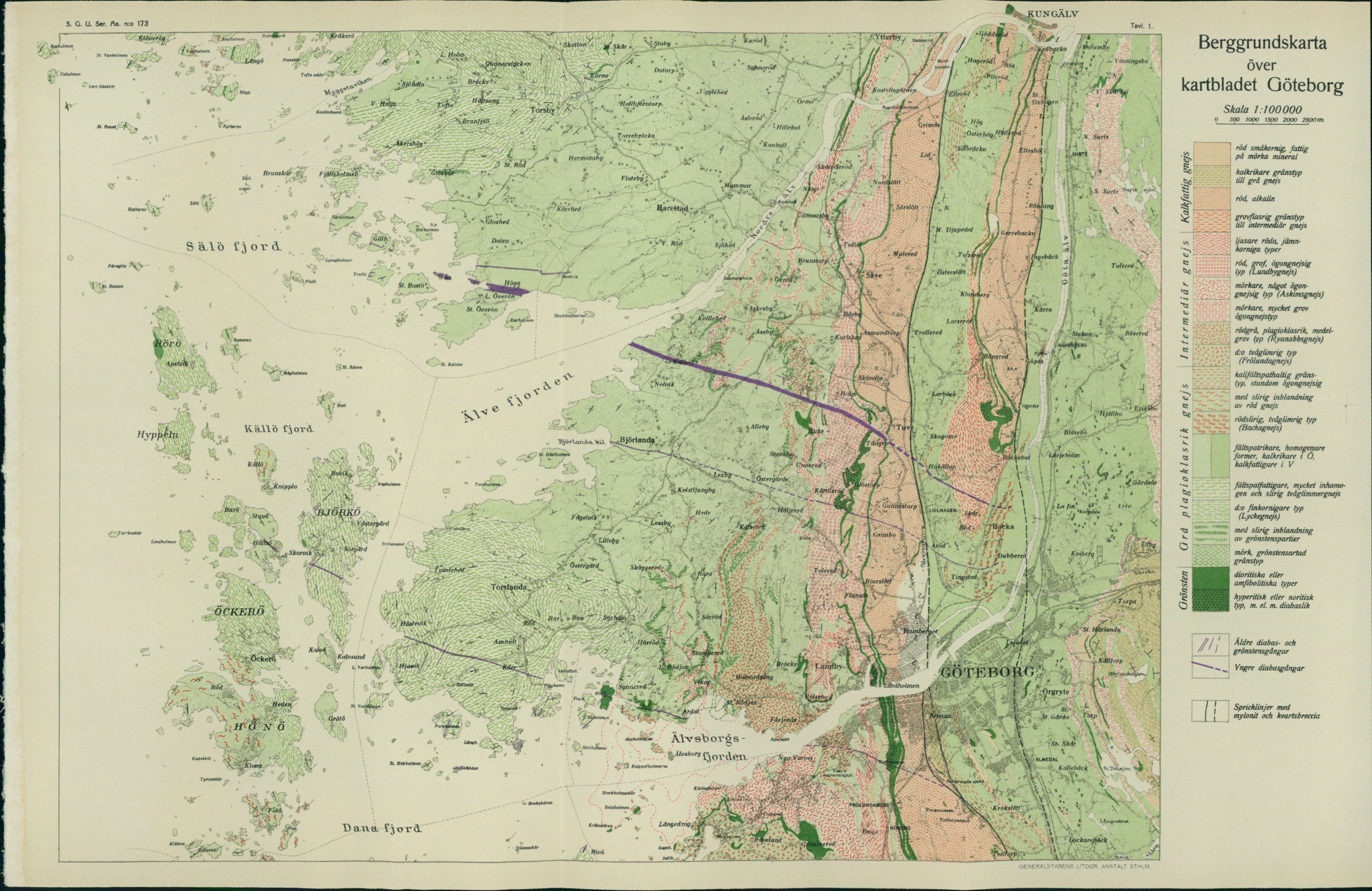
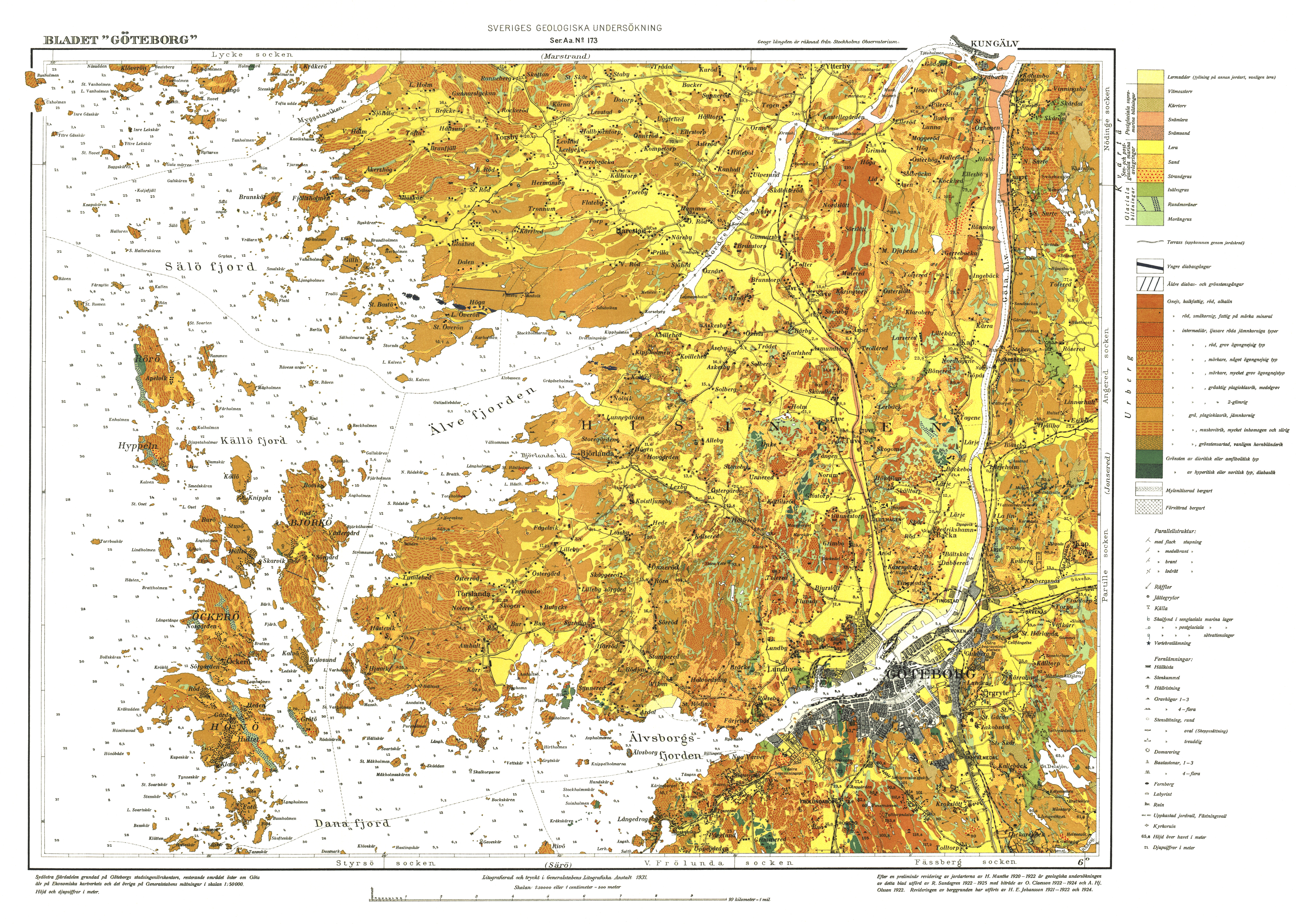
Bedrock map of map sheet Göteborg Scale 1:100 000. 0–2500 m.
Legend:
- red, fine-grained, poor in dark minerals
- more calcareous transitional type to grey gneiss
- red, alkaline
- coarse-flaser transitional type to intermediate gneiss
- lighter red, even-banded types
- red, coarse, augen gneiss type (Lundby gneiss)
- darker, somewhat augen gneissic type (Askims gneiss)
- darker, very coarse augen gneiss type
- red-grey, plagioclase-rich, medium-grained type (Ryanabb gneiss)
- do. two-mica type (Frölunda gneiss)
- potassium-feldspar-bearing transitional type, sometimes augen gneissic
- with streaky admixture of red gneiss
- red-streaked, two-mica type (Backa gneiss)
- feldspar-richer, more homogeneous forms, more calcareous in the E, less calcareous in the W
- feldspar-poorer, very inhomogeneous and streaky two-mica gneiss
- do. finer-grained type (Lycke gneiss)
- with streaky admixture of greenstone portions
- dark, greenstone-like transitional type
- dioritic or amphibolitic types
- hyperitic or noritic type, more or less diabase-like
- Older diabase and greenstone dykes
- Younger diabase dykes
- Fracture zones with mylonite and quartz breccia
[VISUAL PLATE: The entire bedrock map with place names, boundaries, colours, patterns, and the spatial relationships of symbols preserved as source image. Place names shall not be translated.]
GEOLOGICAL SURVEY OF SWEDEN PUBLISHED
Ser. Aa Geological map sheets
No. 121 Skövde by H. Munthe » 144 Nyed by N. H. Mai » 156 Ronehamn by H. J » 157 Skrikerum by E. S » 158 Valdemarsvik by » 159 Ousutn by B. Askl » 160 Klintehamn by H. • 161 Gotska Sandön by » 162 Karlsborg by A. H. » 163 Mariestad by A. B » 164 Hemse by H. Munthe » 165 Filipstad by N. H. » 166 Lurö by R. Sandegren » 167 Säffle by N. H. M » 168 Malingsbo by A. H » 169 Slite by H. Munthe » 170 Katthammarsvik by » 173 Göteborg by R. Sandegren
Ser. Ba Overview maps. No. 11 Overview map of (Southern Sweden) 1 : 500 000. 1923 Ser. C.
No. 340 Lundqvist, G., Örtj Zusammenfassung » 341 Sahlström, K. E., 1 plate. 1926 » 342 Höbner, N. G., Bra its dunes. With » 343 Gkijer, Per, Som With analyses by » 344 Assarsson, G., Anc With one plate. 19 » 345 Ekström, G., Klass
No. 346 Munthe, H., Stad i summary of contents. » 347 von Post, L., Svi studie i Ancylus ice age Göta älv river. 1928 » 348 Santesbon, G., Gn distribution within » 349 Granlund, E., Seng With one map. 1 » 350 Beskow, G., Södra phische und geol Hochgebirges. 5
Price kr. Year Book 22 (1928).
N:o 351 Geijer, Per, Masugnsbyfältens geologi. With a map. Summary: Geo logy of the Iron Ore Fields at Masugnsbyn. 1929… 1,00 » 352 Johansson, S., Nyare jordarts- och markreaktionsundersökningar och deras betydelse for jordbruket. With 2 plates. 1929 … 1,00 > 353 Lundqvist, G., Studier i Ölands myrmarker. With 9 plates. Résumé in deutscher Sprache. 1928 … 3,00 » 354 Asklund, B., Kalirika bergarter inom södra och mellersta Sverige jämte en kort översikt av den svenska experimentverksamheten för fram ställning av kaligödselmedel. English summary. 1929 … 1,00 » 355 Westergård, A. H., A deep boring through Middle and Lower Cam brian strata at Borgholm, Isle of Öland. 1929 … 1,00 Year Book 23 (1929).
N:o 356 Beskow, G., Om jordarternas kapillaritet. En ny metod för bestäm ning av kapillärkraften (eller kapillära stighöjden). Summary: on the capillarity of soils. A new method for determining the capillary pressure (or the capillary rise). 1930 … 1,00 * 357 Assarsson, G. and Sundius, N., On the constitution of hydrated Port land cement. With one Plate. 1929 … 0,60 > 358 Munthe, H., Några till den fennoskandiska geokronologien knutna frågor. 1929 … 0,50 » 359 Sahlström, K. E., Förteckning över lodade sjöar i Sverige. 2. 1929 0,60 » 360 Magnusson, N. H., Gillbergaskålens byggnad. With 2 plates. Summary: The Gillberga syncline. 1929 … 2,00 > 361 Hedström, H., Fosforitbollar från Visingsöserien? 1930 … 0,50 » 362 Hedström, H., Mobergella versus Discinella: Paterella versus Scapha le Archaeophiala. (Some questions on nomenclature.) 1930 . … 0,50 » 363 Hägg, R., Die Mollusken und Brachiopoden der Schwedischen Kreide. 1. Eriksdal. Mit 5 Tafeln. 1930 … 2,00
Ser. Ca. Dissertations and papers in 4:o. N:o 13 Magnusson, N. H., Nordmarks malmtrakt. Geological description. Sum mary: The Iron and Manganese ores of the Nordmark district. 1929 7,00 » 19 Wedekind, R., Die Zoantharia rugosa von Gotland (bes. Nordgotland). Nebst Bemerkungen zur Biostratigraphie des Gotlandiums. Mit 30 Tafeln. 1927 … 8,00 > 20 Geijer, Per, Stråssa och Blanka järnmalmsfält, Geological description. With 5 plates. Summary: The Iron Ore Fields of Stråssa and Blanka. 1927 … 5,00 » 22 Geijer, Per, Gällivare malmfält. Geological description. With 4 plates. With a summary: Geology of the Gällivare iron ore field. 1930 . . 10,00 » 23 Magnusson, N. H., Långbans malmtrakt. Geological description. With 10 plates. Summary: The iron and manganese ores of the Långban district. 1930 … 8,00
Distributed through Generalstabens Litografiska Anstalt, Stockholm 8